Tag Archives: Cyclone

A bomb cyclone will bring winter weather with extreme winds back to the South and Northeast this weekend

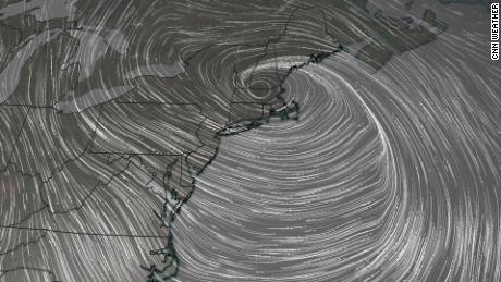
A combination of extremely strong winds and snow promises to wreak havoc over the Northeast as the cyclone reaches hurricane-level strength off the Atlantic coast.

Blizzard-like conditions and widespread wind damage are prominent concerns across the interior of the Northeast.

“All model guidance has surface wave (the storm) rapidly intensifying as it tracks somewhere between the I-95 corridor to Cape Cod, then along or just off the Maine coast as a sub 970 mb low,” said the National Weather Service in Boston.

A 970 millibar low would be equivalent to a Category 2 hurricane.

The low will continue to strengthen overnight Saturday, which, in conjunction with very cold air moving into the area, “will support strong to perhaps damaging winds as the low exits southern New England late Sat into Sat night,” the weather service said.

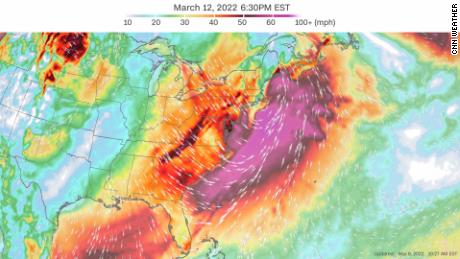
The models are showing the potential for the low-pressure system to intensify rapidly as it moves northward up the Atlantic coast, creating the potential for a bomb cyclone.

The strongest winds are forecast to be off the coast of the Northeast in the Atlantic Ocean, with winds up to 70 mph possible. However, cities including New York City, Boston and Washington, DC, can expect extremely powerful wind gusts ranging from 30 to 50 mph, which raises concerns for falling trees and power outages across the region.

Along with powerful winds, parts of New England will see heavy snow with accumulations of 4 to 8 inches possible in upstate New York and northern Pennsylvania.

“There is increasing confidence that precipitation will generally be in the form of all snow across far northern Maine, especially the north Maine woods, where significant snow accumulations will be possible Saturday into Saturday night,” the weather service in Caribou said.

Get weekly updates from our team of meteorologists

The combination of significant snowfall in these areas with the strong winds from the bomb cyclone will create the potential for hazardous blowing and drifting snow in the area. This could lead to whiteout conditions and make travel extremely dangerous.

Snow totals along the Atlantic coast are forecast to remain low, with only 1 to 3 inches expected.

The current forecast is calling for 1/2” to 1″ of snow across New York City, metro New Jersey, and central and western Long Island,” the weather service in Upton, New York, said.

Higher elevations of Massachusetts are expected to see 2 to 3 inches, with only a dusting to 1 inch expected near Boston, according to the weather service.

The South will also feel the return of winter

The storm will take aim at the Deep South and Southeast first. Cities including Atlanta, Birmingham, Alabama, and Charleston are expected to see heavy rainfall and possible thunderstorms as the system moves in from Friday night to Saturday morning.

This precipitation will change into a wintry mix in some locations and eventually snow as the cold front causes temperatures to plummet well below average.

Snow is forecast to be seen across parts of many Southern states including Alabama and Mississippi. Even Louisiana could see a few flakes mixed in with the rain.

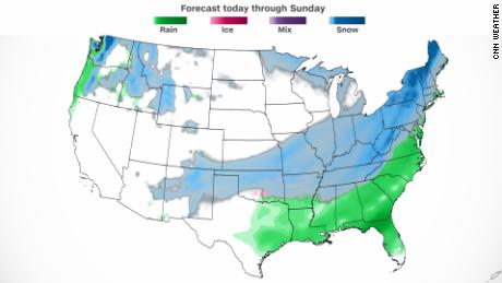
“Currently in the forecast we have a large area of the region mainly eastern Arkansas and west Tennessee with 1 to 2 inches of accumulation for the Friday night into Saturday morning time frame,” the weather service in Memphis, Tennessee, said.

The fast nature of the storm and the well-above-freezing temperatures will keep snow accumulations to a minimum and limit hazards to travel across the mid-South, according to the weather service in Little Rock, Arkansas.

As the system moves out Saturday into Sunday, extreme winter temperatures will grip the eastern US.

Keep that winter coat out for a little while longer

The start of this week brought widespread warm temperatures across much of the East, with some even setting record high temperatures.

Newark and Central Park both set their highest temperatures on record Monday, reaching 76 degrees and 74 degrees respectively.

But another wave of arctic air following the cold front will bring temperatures to the other end of the spectrum.

Check how cold your temperatures will plunge

“Behind the front, much below normal temperatures are expected from the lower Mississippi Valley through the Ohio Valley on Saturday, and into much of the East by Sunday, with daytime highs 20-30 degrees below normal in some places,” the Weather Prediction Center said.

Low temperatures across the South are forecast to get down into the teens this weekend, with wind chills around zero degrees in some areas.

There is hope for those ready for more of that spring weather in the near future, as warmer temperatures should return early next week.

Read original article here

Massachusetts, swaths of Northeast dig out from ‘bomb cyclone’ – The Washington Post

  1. Massachusetts, swaths of Northeast dig out from ‘bomb cyclone’ The Washington Post
  2. Incredible video shows Nantucket UNDERWATER as winter storm barrels through New England Daily Mail
  3. Nantucket police chief provides update on power outages, road flooding during powerful nor’easter WCVB Channel 5 Boston
  4. More than 50K remain without power after nor’easter batters Bay State with heavy snow, strong wind Boston News, Weather, Sports | WHDH 7News
  5. Tens of thousands on East Coast left without power after mighty nor’easter New York Post
  6. View Full Coverage on Google News

Read original article here

Noreaster bomb cyclone storm: The worst of the storm that slammed the Northeast with record snowfall has passed, but ‘dangerously cold’ wind chills remain in some areas

Roughly one million people across the Northeast were under winter weather alerts early Sunday, down from the nearly 16 million who were affected by such alerts Saturday night.

“That is a huge drop-off as the storm exits the most populous areas of the eastern seaboard,” CNN meteorologist Derek Van Dam said.

Blizzard warnings — which affected millions across multiple states Saturday — have also been scaled down to eastern and northern Maine, where more than 240,000 people were affected as of 1 a.m. Sunday, according to the National Weather Service (NWS).

A blizzard, as defined by the NWS, requires blowing or falling snow, winds of at least 35 miles per hour, and visibility of a quarter mile or less for at least three hours.

Those conditions were reached Saturday in several locations across Rhode Island and eastern Massachusetts, including Boston, the NWS said.

Wind speed — which reached more than 80 mph Saturday across eastern Massachusetts — is expected to ease to about 15-25 mph Sunday, though gusts could be higher in some local areas, according to Van Dam.

Sign up for weather email alerts
Still, much of the Northeast can expect “dangerous” wind chills, some dipping below zero Sunday morning as the storm exits the region, the NWS warned. More than 760,000 people from parts of western Virginia through Maine are under those warnings effective until 7 a.m. in some areas and 10 a.m. in others.

Later Sunday, some areas including Buffalo, New York, and Pittsburgh will see temperatures improve by roughly 10 degrees.

Meanwhile, cities including New York, Boston and Philadelphia will see a slight dip of about 4 degrees Sunday.

“Although temperatures are going to rebound (Sunday), we will have to be patient for any real warm up, which doesn’t come until the middle of the week,” Van Dam said.

The frigid cold follows dense snowfall that broke records throughout the Northeast in parts of southern New Jersey, New York, Pennsylvania and Massachusetts.

The storm became a “bomb cyclone” Saturday morning, meaning it strengthened rapidly and had the barometric pressure drop more than 24 millibars within 24 hours, the Weather Prediction Center said.

The storm wreaked havoc on transportation in the region, creating dangerous conditions on roadways and delays and cancellations on air and rail travel.

More than 3,580 flights within, into or out of the US were canceled Saturday, according to FlightAware, and more than a thousand were already canceled for Sunday as of the early morning. Major airlines offered waivers and alternative options to passengers whose travel was affected by the storm.

Record snow and roaring winds

The bomb cyclone brought heavy snow that accumulated quickly as howling winds blew through the region.

The town of Stoughton, Massachusetts, recorded a staggering 30.9 inches of snowfall by Saturday night, the NWS said. And winds in parts of Barnstable County, Massachusetts, where Cape Cod is located, reached 81 mph Saturday, the service said.

By Sunday morning, up to 2 feet of snow could fall from Long Island through Rhode Island, Massachusetts, New Hampshire and Maine, CNN forecasters said.

Here are some notable snowfall records:

  • Atlantic City, New Jersey: The city crushed its all-time January snowfall record by Saturday, reaching a monthly total of 33.2 inches of snow. The prior monthly record of 20.3 inches was set in January 1987. The city’s 14 inches of snow Saturday also beat its previous record for the calendar date, which was set in 2014 at 7.3 inches.
  • Boston: Logan International Airport tallied at least 23.6 inches of snow by Saturday night, said the NWS, making Saturday the snowiest January day Boston has recorded and tying the record for biggest 1-day snowfall total. The previous record was set on January 27.
  • Central Park, New York: The iconic park saw 7.3 inches on Saturday, beating the previous record for January 29 of 4.7 inches set in 1904.
  • Philadelphia: The city was hit with 5.8 inches of snow Saturday, beating the previous calendar day record of 5 inches set on January 29, 1904.

Power outages remain

The storm’s strong winds lead to downed power lines, leaving thousands still in the dark.

Nearly 65,000 homes and businesses in Massachusetts were without power early Sunday according to PowerOutage.us, down from more than 88,000 Saturday evening.

High winds and snow pushed over several trees across Nantucket Island while some areas were out of power because of downed wires, island Fire Chief Stephen Murphy told CNN Saturday afternoon. Several roadways were also closed because of flooding, the chief said.

“We do have coastal flooding when we get these kinds of storms, but today was pretty intense,” Jason Graziadei, an editor at the local newsletter Nantucket Current, told CNN. “People (are) kind of just hunkering down out here.”

Scituate, a coastal Massachusetts town southeast of Boston, had some mild to moderate flooding at high tide Saturday morning, with water splashing over seawalls, town administrator Jim Boudreau told CNN.

In Marshfield, another coastal Massachusetts town, about 4 feet of water came over the seawall at high tide, town administrator Michael A. Maresco told CNN.

CNN’s Jason Hanna, Christina Maxouris, Brynn Gingras, Brian Todd, Artemis Moshtaghian, Liam Reilly, Tyler Mauldin and David Williams contributed to this report.


Read original article here

Nor’easter bomb cyclone: For 55 million Americans from the Mid-Atlantic states to New England, snow, wind and flooding are in store

The storm is expected to form Friday off the coast of the Carolinas and then move northward up the East Coast overnight into Saturday as it rapidly strengthens in a process called bombogenesis. Also referred to as a bomb cyclone, the process happens when a storm drops a certain amount of atmospheric pressure over a 24-hour period.

Eastern Massachusetts, including Boston, and Rhode Island could see between 12 to 24 inches of snow combined with wind gusts up to 64 mph, according to multiple forecast models.

“It is looking likely that blowing snow would result in significantly reduced or near-zero visibilities at times for southeastern MA. Right now, we are most confident in blizzard conditions developing from Plymouth County into Cape/Islands,” the National Weather Service office in Boston warned Thursday night.
Additionally, much of the New England coast also faces the threat of a dangerous blizzard, according to the NWS Weather Prediction Center. A blizzard occurs when snow is joined by winds gusting over 35 mph for more than three hours and creates visibility of less than a quarter of a mile.
“Whiteout conditions could create nearly impossible travel, while strong winds will likely lead to scattered power outages and some damage,” the center said.

Mix of snow, wind and coastal flooding to slam Northeast

The storm is expected to unleash a double-whammy of heavy snowfall and strong winds throughout parts of the Northeast, but exactly which parts of the region remain in question.

“This storm is likely to strengthen at a rate, and to an intensity, equivalent to only the most powerful hurricanes, so the high-end potential of this storm cannot be overstated,” CNN meteorologist Brandon Miller said. “But with nor’easters, like in real estate, it will all come down to location, location, location.”

Portions of northeastern North Carolina and southeastern Virginia could see up to 3 inches of snow, with winds as high as 35 mph, according to the National Weather Service.

And once the storm reaches the East Coast, it can dump as many as 14 inches of snow in portions of Connecticut and New York, where wind gusts may reach as high as 55 mph, the NWS predicts. But forecast models remained uncertain Thursday.
In neighboring New Jersey, northeastern parts of the state can see up to 9 inches of snow as winds gusts reach as high as 50 mph, the NWS said.
The storm could also drop up to 8 inches of snow in Philadelphia, while portions of Delaware may see as many as 10 inches, according to multiple forecast models.

Pus, coastal flooding as well as extremely cold temperatures are a possibility, the Weather Prediction Center warned.

The stronger the storm, the greater the surge of water along the coast will be.

“Coastal flooding is a concern thanks to astronomically high tides on Saturday,” NWS Boston said. “The combination of strong northeast winds and high seas will bring storm surges that, if coinciding with high tide, would lead to minor or moderate coastal flooding.”

The difference in storm timing — even as few as six hours — would make a massive difference in impact on coastal flooding and erosion concerns.

New York City forecast remains uncertain

And while the storm’s track has become clearer over the past 24 hours, its impact in some areas is still unpredictable.

A European forecast model shows New York City on the edge of the snow-or-no-snow divide, but it still predicts a heaping pile of snow. The American model shows nearly nothing for the city. A third model indicates a foot or more of snow.

The NWS prediction as of early Friday is between 6 and 9 inches of snow, with wind gusts up to 50 mph. However, it says there is a 10% chance that the bomb cyclone may dump more than 17 inches of snow — while also giving a 10% chance of zero snow.

And direction is playing a vital role in this storm’s projection, CNN meteorologist Chad Myers pointed out.

“It’s like a bowling ball going right down the middle or slightly off-center. You can get a 7-10 split or a strike with only an inch difference,” Myers said. “I think the models will come together as we get closer to the event.”

CNN’s Judson Jones and Robert Shackelford contributed to this report.


Read original article here

Noreaster bomb cyclone: Northeast faces heavy snow and blizzard conditions this weekend, but models are still unclear on how bad it will be

Forecasters predict eastern Massachusetts, including Boston, and Rhode Island will see significant impacts, with the expectation of 8 to 16 inches of snow combined with wind gusts up to 60 mph.

Five million people in the region will be under a winter storm watch effective Friday night through Saturday evening, according to the National Weather Service.

The storm is expected to form in the Atlantic Ocean just off the coast of Georgia, then rapidly strengthen — a process known as bombogenesis — overnight Friday and track up the East Coast Saturday, though specifics on the impact remain unclear.

“This storm is likely to strengthen at a rate, and to an intensity, equivalent to only the most powerful hurricanes, so the high-end potential of this storm cannot be overstated. But with nor’easters, like in real estate, it will all come down to location, location, location,” CNN meteorologist Brandon Miller said.

Sign up for weather email alerts
Heavy snow and strong winds are likely across New England, “which could lead to blowing snow, scattered power outages, and some damage,” the Weather Prediction Center said Wednesday evening.

Moderate to heavy snow is possible from New York through Washington, DC, “but confidence in potential impacts is much lower,” the forecasters said.

The storm could potentially dump up to 8 inches of snow in Philadelphia and New York City, while Washington, DC, could see up to 2 inches, according to multiple forecast models.

The double threat of heavy snow and strong winds has the potential to create blizzard-like conditions through the Northeast.

A blizzard occurs when snow is joined by winds gusting over 35 mph for more than three hours and creates visibility of less than a quarter of a mile.

Uncertainty in the forecast

Forecasters have been reinforcing the point that it’s still too early to predict the precise impact of the storm and snowfall totals.

“The storm track remains uncertain which will have a direct impact on accumulations and where heaviest snowfall sets up,” the NWS in Boston said Thursday morning.
A “farther offshore track of the low will decrease snow amounts while a track closer to shore will increase snow amounts and if the low gets close enough to the coast, a wintry mix will be possible for some eastern coastal sections (This is looking less and less likely),” said the New York office of the National Weather Service said Wednesday.

Different forecast models show different paths for the storm, which makes it hard to nail down precisely what will happen, the NWS said.

CNN meteorologist Robert Shackelford explained those discrepancies are largely because each model uses different methods to determine their forecast.

“All options remain on the table as it’s still 3 days away and we can’t rule out a shift back to the west or even a further eastward shift with less snow,” forecasters said early Thursday morning.

How to survive a blizzard

Coastal flooding is a possibility

In addition to gusting wind and blowing snow, coastal flooding may also be in store for some areas.

“Significant coastal impacts are possible in the Northeast, including coastal flooding and beach erosion,” the prediction center said.

The stronger the storm, the greater the surge of water along the coast will be.

“Coastal flooding is a concern thanks to astronomically high tides on Saturday,” the Boston weather service office said. “The combination of strong northeast winds and high seas will bring storm surges that, if coinciding with high tide, would lead to minor or moderate coastal flooding.”

The difference in storm timing — even as few as six hours — would make a massive difference in impact on coastal flooding and erosion concerns.

Meanwhile, a blast of arctic air is set to enter the northern US Thursday, bringing scattered snow showers across the Great Lakes region, the National Weather Service said.

The region also experienced icy conditions Wednesday, with crashes reported in northern Indiana after drivers lost control of their vehicles on slick bridges, officials said.

A FedEx semi-truck was left dangling off a bridge on the Indiana Toll Road in St. Joseph County when the driver lost control after being hit by another vehicle that had also lost control, Sgt. Ted Bohner, spokesman for the Indiana State Police District 24.

The FedEx truck hit another vehicle in the rear causing that vehicle to spin out and the FedEx truck to hit a concrete barrier wall of a bridge, Bohner said.

Another car also lost control on the icy roads, hitting and flipping over a guardrail, officials said. The van “rolled or slid down the embankment and almost went onto a road running parallel to the Toll Road,” Bohner said.

CNN’s Judson Jones and Jennifer Henderson contributed to this report.


Read original article here

Nor’easter forecast: A bomb cyclone with hurricane power will unleash snow this weekend

“The models continue to show a nor’easter with blockbuster potential for the weekend, mainly late Friday through Saturday,” CNN meteorologist Brandon Miller says.

There are still questions about how much snow will pile up and how extreme winds will get.

“Heavy snow is most likely in parts of New England,” the Weather Prediction Center said Wednesday morning. “Heavy snow is still possible farther south along the East Coast, including the major I-95 metropolitan areas from New York City to Washington DC, but that is more uncertain at this time.”

The National Weather Service in Boston on Wednesday afternoon issued a winter storm watch for eastern Massachusetts and Rhode Island, from Friday night until Saturday evening. Expected snowfall ranges from 8 to 16 inches, with wind gusts up to 60 mph.

Other NWS offices have yet to issue watches due to the uncertainty.

Sign up for weather email alerts
The storm is expected to form in the Atlantic Ocean just off the coast of Georgia, then rapidly strengthen — a process known as bombogenesis — overnight Friday and track Saturday up the East Coast.
“Guidance indicates potential for this storm to undergo bombogenesis, meaning its central pressure drops at least 24 mb in 24 hours,” the Boston weather service office said earlier, referring to the unit of pressure known as millibars. “This creates a very tight pressure gradient, meaning strong, potentially damaging winds will accompany the snow.”

“This storm is likely to strengthen at a rate, and to an intensity, equivalent to only the most powerful hurricanes, so the high-end potential of this storm cannot be overstated. But with nor’easters, like in real estate, it will all come down to location, location, location,” Miller said.

Bookmark this page for National Weather Service snow forecasts
Uncertainty in the forecast is pretty common more than 48 hours before a storm even has formed, as the Boston National Weather Service office noted Wednesday on Twitter.

“Well, the average model error at this time range (3 days out) is over 150 miles! For example, where will the rain/#snow line setup? 150 miles could range from Cape Cod, MA to New Haven, CT. Hence, still too early.”

Both forecast models predict this strengthening, but their storm tracks up the East Coast are different, changing what people could expect from Washington, DC, to Boston.

Compare forecast models and delay information

“For those that have been following along, I know you’ve heard it repeated to death, but the key message continues to be the same: guidance is trending favorably for a big storm, but the exact track remains uncertain,” the Boston office said. “This track is what will tell us exactly where the greatest snow, wind, and coastal flooding concerns are.”

A “farther offshore track of the low will decrease snow amounts while a track closer to shore will increase snow amounts and if the low gets close enough to the coast, a wintry mix will be possible for some eastern coastal sections (This is looking less and less likely),” said the New York office of the National Weather Service.

Blizzard conditions, coastal flooding are on the table

While it’s too early to pinpoint exact totals, it looks like the storm will hit all metro areas along Interstate 95 from Virginia to Maine starting Friday and through the day Saturday. Philadelphia, New York and Boston could get a foot of snow — or much more.

Winds of 50 mph or more are likely throughout the Northeast, with even higher gusts possible, especially along the eastern coastlines. These strong winds combined with snow will create blizzard conditions.

“A closer track would also mean higher winds and potential for blizzard conditions near the coast,” the weather service office in Philadelphia said.
How to survive a blizzard

A blizzard happens when snow combines with winds gusting over 35 mph for more than three hours and creates visibility of less than a quarter of a mile.

“Significant coastal impacts are possible in the Northeast, including coastal flooding and beach erosion,” the prediction center said.

The stronger the storm, the greater the surge of water along the coast will be. Timing also matters a lot.

“Coastal flooding is a concern thanks to astronomically high tides on Saturday,” the Boston weather service office said. “The combination of strong northeast winds and high seas will bring storm surges that, if coinciding with high tide, would lead to minor or moderate coastal flooding.”

The difference in storm timing — even as few as six hours — would make a massive difference in impact on coastal flooding and erosion concerns.

One thing is sure: Meteorologists will be glued to computer forecast model runs all day Wednesday.

“Today’s trends will certainly be important,” the weather office in Philadelphia said. “Sampling will be steadily improving, and ‘big picture’ model solutions should start converging in the next 12 to 24 hours.”

In layman’s terms: We will know more details Thursday.


Read original article here

Bomb cyclone could bring powerful nor’easter to Northeast cities this weekend

“Confidence is increasing that a significant winter storm will create considerable impacts Friday through the weekend from the Mid-Atlantic through the Northeast,” the Weather Prediction Center said Tuesday morning.

The storm is expected to move up the East Coast Friday into Saturday — its location in relation to the coast will determine whether there’s a wintry mix or a foot of snow.

Unfortunately, the forecast models are split on exactly where the low pressure system tracks and how strong it becomes by the end of the week.

It’s important to note that the forecast models change daily, and there is no reason to believe that the newer model runs are any more reliable than yesterday’s runs.

But despite the ongoing uncertainties, “it is becoming more likely that it will bring significant snow, sleet and freezing rain to the region, including the I-95 metropolitan areas,” the Weather Prediction Center added.

The National Weather Service office in Philadelphia also reiterated on Tuesday that the current forecasts for this storm are similar to other 3-5 day forecasts of past significant storms — a reason to watch this closely going forward.

Snow and ice accumulations could end up being significant. The weather service office in Boston also noted on Tuesday that some of the models have the low pressure system going right over a forecasting sweet spot known as the “70/40 Benchmark”.

Low pressure systems tracking over this spot — the intersection of 40 degrees North latitude and 70 degrees West longitude — are known for being significant in the Northeast, often bringing large amounts of snowfall to the area.

If this occurs on Friday, a swath of 8 to 12 inches of snow is very likely over areas in southern New England.

While the focus of nor’easters is typically for the Northeast, the Mid-Atlantic may also see large impacts from this system.

“This system is not a slam dunk by any means,” the office in Baltimore said Tuesday morning. “Nonetheless, the overall pattern for the event seems to be honing in on a snowy solution for much of the area.”
As the storm moves up the East Coast it is expected to strengthen rapidly, possibly becoming a bomb cyclone with strong, even damaging, winds that could cause coastal flooding and beach erosion.

High astronomical tides will combine with the winds along the Atlantic coastline and may lead to significant coastal flooding.

Read original article here

After ‘bomb cyclone’ soaks West Coast, Yosemite Falls roars back to life

A powerful storm that drenched the West Coast with record-breaking rainfall and hurricane-force winds triggered landslides, flooded roads and left two people dead in Washington State.

It also resurrected one of California’s most iconic natural features — Yosemite Falls.

Before a “bomb cyclone” slammed into the state Sunday, dropping nearly a foot of rain in some parts of a region strained by a climate change-fueled megadrought, the 2,425-foot falls had all but vanished, as often happens by late summer or fall.

But by Monday, more than six inches of rain had fallen across Yosemite Valley in 36 hours, the park said on Facebook. And the falls roared back to life, as one observer put it on Twitter.

“This is such a joy to see,” one user responded. “I’m so happy to see the water,” added another. “We need it badly.”

Although experts said the storm dropped nowhere near enough water to quench the drought, Daniel Swain, a climate scientist at the University of California Los Angeles, said it will still reduce its severity in many places, not to mention extinguish the state’s wildfire season.

“Overall it appears that this event was, on a statewide basis, more beneficial than harmful despite its extremity,” he said.


Read original article here

NFL fans brave bomb cyclone to watch 49ers-Colts game

A weather system known as a bomb cyclone moved through the Bay Area on Sunday night and had a tremendous effect on the game between the San Francisco 49ers and the Indianapolis Colts.

Levi’s Stadium was drenched in rain throughout the night, but fans managed to sit either in their seats and brave the rain or park themselves on the concourse to watch under the awning. There were dozens of people in their seats with ponchos on and hoods up to watch the big game.

CLICK HERE FOR MORE SPORTS COVERAGE ON FOXNEWS.COM

San Francisco 49ers defensive back Emmanuel Moseley, left, defends a pass intended for Indianapolis Colts wide receiver Ashton Dulin during the second half of an NFL football game in Santa Clara, Calif., Sunday, Oct. 24, 2021.
(AP Photo/Jed Jacobsohn)

Twitter was lit up with interesting sights and sounds from the game.

The weather system began to move through the western United States earlier in the week.

A bomb cyclone is also known as a mid-latitude cyclone, according to the National Oceanic and Atmospheric Administration (NOAA). Mid-latitude cyclones drive most of the stormy weather in the continental U.S., the agency notes.

TOM BRADY LEAVES YOUNG FAN IN TEARS WITH HEARTWARMING GESTURE

Workers push water off a tarp covering the field from rain at Levi’s Stadium before an NFL football game between the San Francisco 49ers and the Indianapolis Colts in Santa Clara, Calif., Sunday, Oct. 24, 2021. A powerful storm roared ashore Sunday in Northern California, flooding highways, toppling trees and causing mud flows as forecasters predict record-breaking rainfall.
(AP Photo/Jed Jacobsohn)

A process called bombogenesis can occur when a mid-latitude cyclone intensifies rapidly over a 24-hour period, dropping at least 24 millibars of atmospheric pressure. Typically, a range in millibar change is around 10 to 15 in that same timeframe. 

This can happen when a cold air mass collides with a warm air mass, like air over warm ocean waters. The formation of the fast-strengthening weather system is bombogenesis, which generates the bomb cyclone.

The effects of the fast-developing low-pressure system include high and intense winds and blizzard and white-out conditions with heavy snow, in addition to rainfall on snow that can cause flooding. It’s not unusual to get at least one storm per year and bombogenesis nor’easters occur frequently during the winter seasons.

Indianapolis Colts running back Jonathan Taylor, left, runs in front of San Francisco 49ers free safety Jimmie Ward (1) during the first half of an NFL football game in Santa Clara, Calif., Sunday, Oct. 24, 2021.
(AP Photo/Jed Jacobsohn)

CLICK HERE TO GET THE FOX NEWS APP

While fumbles were aplenty during the game, both teams on Sunday managed to combine for more than 45 points.

Fox News’ Julia Musto contributed to this report.

Read original article here

‘Bomb Cyclone,’ nor’easter and other severe weather will unfold this week across the US

From “bomb cyclones” to severe weather and nor’easters, this week has it all.

As a “bomb cyclone” ramps up a firehouse of heavy rain across the West, new evacuation orders have been issued for vulnerable locations near recent burn scars.
Santa Barbara County officials upgraded the recent evacuation warning to an evacuation order for parts of the Alisal Fire burn area. Concerns are mounting about dangerous debris flows to develop as heavy rain is forecast to fall over the recently scorched earth.

Evacuation orders mean that it is unlawful to remain in place, with an immediate threat to life and property.

The threats associated with this atmospheric river don’t stop there. Several feet of snow are forecast for the Sierra Nevada mountain range creating nearly impossible driving conditions, according to the National Weather Service (NWS) office in Hanford, California.

Expect major travel delays as chain controls and roadway closures are likely to be enforced. The most intense snowfall will occur Sunday night into Monday and will be heaviest at elevations above 5,000 feet.

Strong winds gusting over 50 miles per hour will accompany the heavy, wet snow.

The NWS has flash flood watches across a large expanse of central and northern California. Rainfall accumulations of 3 to 6 inches, with locally higher amounts exceeding 10 inches, will lead to localized flash flooding, mudslides and rockslides.

Particularly vulnerable roadways and streams are most at risk with this event, as the heavy rain is forecast to last into Monday.

Significant tornado outbreak possible Sunday

Severe weather is possible early this week for a large part of the country.

A temperature battleground is setting the stage for an outbreak that will begin Sunday across the mid Mississippi Valley and move east to the Carolinas and mid-Atlantic states by Monday.

Tornadoes, large hail and damaging winds are all possible Sunday across parts of Arkansas, Missouri, Illinois and Indiana.

However, the Storm Prediction Center has highlighted a specific area from St. Louis to Springfield, Missouri, as having a significant threat for tornadoes. This region has a greater than 10% probability of a strong tornado (EF-2 to EF-5) within 25 miles of any particular point.

Fall is commonly considered a secondary peak season for severe weather in the US.

Large temperature swings associated with the changing seasons can help fuel severe weather development. Even though tornadoes can occur anytime of the year, fall typically experiences an uptick in activity as warm, humid air from the south interacts with increasingly more potent cold fronts from the north.

Weather models hint at possible nor’easter midweek

The same energy associated with the severe weather outbreak will translate to a powerful low pressure system known as a nor’easter along the East Coast of the US by Tuesday and Wednesday.

Conditions are looking favorable for strong northeasterly winds to develop, which is how a nor’easter gets its name. Coastal flooding and heavy rain are also possible across southern New England.

Specific forecast details are still unknown, as this event is still several days away, but the potential exists for urban and street flooding. Some computer models predict more than 6 inches of rain for the region.

As the autumn leaves are still yet to fall across much of New England, gusty winds could easily topple trees and branches. This may potentially lead to power outages across the region.

Read original article here