Forecasters predict eastern Massachusetts, including Boston, and Rhode Island will see significant impacts, with the expectation of 8 to 16 inches of snow combined with wind gusts up to 60 mph.
Five million people in the region will be under a winter storm watch effective Friday night through Saturday evening, according to the National Weather Service.
“This storm is likely to strengthen at a rate, and to an intensity, equivalent to only the most powerful hurricanes, so the high-end potential of this storm cannot be overstated. But with nor’easters, like in real estate, it will all come down to location, location, location,” CNN meteorologist Brandon Miller said.
Moderate to heavy snow is possible from New York through Washington, DC, “but confidence in potential impacts is much lower,” the forecasters said.
The storm could potentially dump up to 8 inches of snow in Philadelphia and New York City, while Washington, DC, could see up to 2 inches, according to multiple forecast models.
The double threat of heavy snow and strong winds has the potential to create blizzard-like conditions through the Northeast.
A blizzard occurs when snow is joined by winds gusting over 35 mph for more than three hours and creates visibility of less than a quarter of a mile.
Uncertainty in the forecast
Forecasters have been reinforcing the point that it’s still too early to predict the precise impact of the storm and snowfall totals.
Different forecast models show different paths for the storm, which makes it hard to nail down precisely what will happen, the NWS said.
CNN meteorologist Robert Shackelford explained those discrepancies are largely because each model uses different methods to determine their forecast.
“All options remain on the table as it’s still 3 days away and we can’t rule out a shift back to the west or even a further eastward shift with less snow,” forecasters said early Thursday morning.
Coastal flooding is a possibility
In addition to gusting wind and blowing snow, coastal flooding may also be in store for some areas.
“Significant coastal impacts are possible in the Northeast, including coastal flooding and beach erosion,” the prediction center said.
The stronger the storm, the greater the surge of water along the coast will be.
“Coastal flooding is a concern thanks to astronomically high tides on Saturday,” the Boston weather service office said. “The combination of strong northeast winds and high seas will bring storm surges that, if coinciding with high tide, would lead to minor or moderate coastal flooding.”
The difference in storm timing — even as few as six hours — would make a massive difference in impact on coastal flooding and erosion concerns.
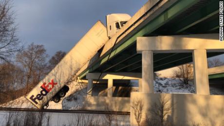
The region also experienced icy conditions Wednesday, with crashes reported in northern Indiana after drivers lost control of their vehicles on slick bridges, officials said.
A FedEx semi-truck was left dangling off a bridge on the Indiana Toll Road in St. Joseph County when the driver lost control after being hit by another vehicle that had also lost control, Sgt. Ted Bohner, spokesman for the Indiana State Police District 24.
The FedEx truck hit another vehicle in the rear causing that vehicle to spin out and the FedEx truck to hit a concrete barrier wall of a bridge, Bohner said.
Another car also lost control on the icy roads, hitting and flipping over a guardrail, officials said. The van “rolled or slid down the embankment and almost went onto a road running parallel to the Toll Road,” Bohner said.
CNN’s Judson Jones and Jennifer Henderson contributed to this report.