Nor’easter bomb cyclone: For 55 million Americans from the Mid-Atlantic states to New England, snow, wind and flooding are in store

The storm is expected to form Friday off the coast of the Carolinas and then move northward up the East Coast overnight into Saturday as it rapidly strengthens in a process called bombogenesis. Also referred to as a bomb cyclone, the process happens when a storm drops a certain amount of atmospheric pressure over a 24-hour period.

Eastern Massachusetts, including Boston, and Rhode Island could see between 12 to 24 inches of snow combined with wind gusts up to 64 mph, according to multiple forecast models.

“It is looking likely that blowing snow would result in significantly reduced or near-zero visibilities at times for southeastern MA. Right now, we are most confident in blizzard conditions developing from Plymouth County into Cape/Islands,” the National Weather Service office in Boston warned Thursday night.
Additionally, much of the New England coast also faces the threat of a dangerous blizzard, according to the NWS Weather Prediction Center. A blizzard occurs when snow is joined by winds gusting over 35 mph for more than three hours and creates visibility of less than a quarter of a mile.
“Whiteout conditions could create nearly impossible travel, while strong winds will likely lead to scattered power outages and some damage,” the center said.

Mix of snow, wind and coastal flooding to slam Northeast

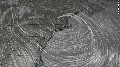
The storm is expected to unleash a double-whammy of heavy snowfall and strong winds throughout parts of the Northeast, but exactly which parts of the region remain in question.

“This storm is likely to strengthen at a rate, and to an intensity, equivalent to only the most powerful hurricanes, so the high-end potential of this storm cannot be overstated,” CNN meteorologist Brandon Miller said. “But with nor’easters, like in real estate, it will all come down to location, location, location.”

What is a bomb cyclone? Here's what you need to know

Portions of northeastern North Carolina and southeastern Virginia could see up to 3 inches of snow, with winds as high as 35 mph, according to the National Weather Service.

And once the storm reaches the East Coast, it can dump as many as 14 inches of snow in portions of Connecticut and New York, where wind gusts may reach as high as 55 mph, the NWS predicts. But forecast models remained uncertain Thursday.
In neighboring New Jersey, northeastern parts of the state can see up to 9 inches of snow as winds gusts reach as high as 50 mph, the NWS said.
Fog shrouds the skyline of lower Manhattan on January 25 as seen from Jersey City, New Jersey.
The storm could also drop up to 8 inches of snow in Philadelphia, while portions of Delaware may see as many as 10 inches, according to multiple forecast models.

Pus, coastal flooding as well as extremely cold temperatures are a possibility, the Weather Prediction Center warned.

The stronger the storm, the greater the surge of water along the coast will be.

“Coastal flooding is a concern thanks to astronomically high tides on Saturday,” NWS Boston said. “The combination of strong northeast winds and high seas will bring storm surges that, if coinciding with high tide, would lead to minor or moderate coastal flooding.”

The difference in storm timing — even as few as six hours — would make a massive difference in impact on coastal flooding and erosion concerns.

New York City forecast remains uncertain

And while the storm’s track has become clearer over the past 24 hours, its impact in some areas is still unpredictable.

A European forecast model shows New York City on the edge of the snow-or-no-snow divide, but it still predicts a heaping pile of snow. The American model shows nearly nothing for the city. A third model indicates a foot or more of snow.

The NWS prediction as of early Friday is between 6 and 9 inches of snow, with wind gusts up to 50 mph. However, it says there is a 10% chance that the bomb cyclone may dump more than 17 inches of snow — while also giving a 10% chance of zero snow.

And direction is playing a vital role in this storm’s projection, CNN meteorologist Chad Myers pointed out.

“It’s like a bowling ball going right down the middle or slightly off-center. You can get a 7-10 split or a strike with only an inch difference,” Myers said. “I think the models will come together as we get closer to the event.”

CNN’s Judson Jones and Robert Shackelford contributed to this report.


Read original article here

Leave a Comment