Tag Archives: Cyclone

Bomb Cyclone and ‘Atmospheric River’ Pummel California With Rain and Wind

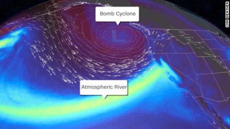
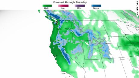
California bore the brunt on Sunday of what meteorologists referred to as a “bomb cyclone” and an “atmospheric river,” a convergence of storms that brought more than half a foot of rain to parts of the Bay Area, along with high winds, concerns about flash floods and the potential for heavy snow in the Sierra Nevada.

The National Weather Service warned that the rainfall could cause mudslides, especially in areas scorched by wildfires.

From Marin County to the area just south of Big Sur along the Pacific Coast, flash flood watches were in effect until late Sunday night and, in some areas, early Monday morning, including parts of the San Francisco peninsula.

The threat of flash floods prompted evacuation orders for parts of San Mateo County, south of San Francisco, where officials warned that downed trees, branches and mudslides could impede efforts to leave. In San Francisco, emergency responders ordered evacuations on one block, where they said several structures were threatened by a tree that was leaning.

The convergence of storms comes at a challenging time for California, which has been besieged by wildfires and drought, the result of extreme weather brought on by climate change.

As of 11:30 a.m. local time on Sunday, at least 66,000 utility customers in the Bay Area had lost power, said J.D. Guidi, a spokesman for Pacific Gas and Electric. About two-thirds of those outages were reported in Sonoma and Marin Counties.

The utility said that more than 3,000 workers and contractors were ready to help restore power. It said it also expected to bring in hundreds of workers from areas that were less affected by the storm, adding that equipment had been moved into position before the storm.

At San Francisco International Airport, 139 flights had been delayed and 52 others had been canceled as of 10:10 a.m. local time, said Cathy Morrison, an airport duty manager.

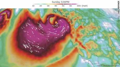
“The atmospheric river is aiming a fire hose, if you will, into our area,” Sean Miller, a meteorologist for the Weather Service in Monterey, Calif., the forecast office for the Bay Area, said on Sunday.

An atmospheric river is a concentrated plume of moisture that extends over the ocean, typically in the troposphere, the lowest layer of the atmosphere, Mr. Miller said, adding that the current trough was angled toward the North Bay.

In the Pacific Northwest, a bomb cyclone, a type of storm known for its falling atmospheric pressure, was expected to push the atmospheric river south, affecting areas south of San Francisco, Mr. Miller said.

“This is more typical of something we tend to see in December or January,” he said, pointing out that the confluence of the two meteorological phenomena was “anomalous.”

The high winds and heavy rain prompted the authorities to close the sidewalks on the Golden Gate Bridge on Sunday. In the East Bay, organizers of the Alameda County Fair closed the event on Sunday because of the storm, while an Ironman triathlon scheduled for Sunday in Sacramento was canceled.

Alcatraz Island canceled all of its tours on Sunday, and the San Francisco and Oakland zoos were also shut.

In San Mateo County, the authorities on Sunday morning ordered people in parts of the county to evacuate. “Please do not wait,” they said in a statement.

Elsewhere in the county, CalFire, the state’s firefighting agency, shared a video on Sunday morning of a small fire on a road that likely had ignited after a pole and a tree fell down. Downed trees have been reported across the northern part of the state.

White it appeared that most of the flooding was reported in the North Bay, landslides and dangerous road conditions were reported in areas across Northern California. Images were shared on social media on Sunday of small and large landslides, including one in Plumas County showing piles of rocks blocking a highway.

The California Highway Patrol in Truckee, north of Lake Tahoe, said on Twitter on Sunday afternoon that rocks and water had fallen down a mountainside, blocking a road.

On Tuesday, Gov. Gavin Newsom issued a proclamation extending California’s drought emergency statewide and asked residents to redouble their water conservation efforts. This has been California’s second driest year on record, with near-record low storage in the state’s largest reservoirs, the governor’s office said.

Severe drought conditions, worsened by climate change, continue to affect much of the Western United States and even the northern part of the Great Plains.

While droughts are not uncommon in the region, scientists say that climate change, in the form of warming temperatures and shifts in precipitation, is making the situation worse.


Read original article here

West Coast braces for simultaneous ‘bomb cyclone’ and ‘atmospheric river’

This will be the third and strongest in a series of storms to strike the West Coast this week.

A bomb cyclone is a system that drops at least 24 mb in pressure 24 hours or less — and typically the lower the pressure, the stronger the storm. Atmospheric rivers are narrow bands of concentrated moisture that cruise more than 2 miles above the ocean and release rain or snow when they hit land — and this one rates level 5 of 5.
“By Saturday night, a rapidly intensifying Pacific cyclone directing a powerful atmospheric river squarely at the West Coast delivers a fire hose of rich subtropical moisture into California,” the Weather Prediction Center said Friday.

These two simultaneous events will result in the season’s first heavy, wet snow across the Sierras and periods of soaking rains for the coastline and valleys across central and Northern California. Areas of Washington and Oregon will also see impacts through the weekend.

Dangerous ‘sneaker waves’ may threaten beach-goers

This system is forecast to rapidly strengthen on approach to the Pacific Northwest, becoming a “bomb cyclone” over the next 24 to 48 hours. This system could be one of the lowest pressure storms to ever develop across the northeastern Pacific Ocean, with a forecast pressure comparable to major hurricanes in the Atlantic.

“I don’t think a lot of people realize that these cyclones in the northern Pacific can be equivalent to a hurricane in the Gulf of Mexico or Atlantic,” Carly Kovacik, a lead meteorologist for the National Weather Service office in Seattle, told CNN. “A lot of these storms produce very strong winds and high seas, but since they are mid-latitude storms, we just don’t call them hurricanes even though the impacts can be very similar.”

Like a hurricane, the track of this particular system matters in terms of what impacts will be felt this weekend across the Pacific Northwest.

If the system takes a more northerly track — like the storm earlier this week did — the impacts will be lesser across Washington and Oregon, Kovacik explained. But if the center of the storm takes a more southerly track toward Vancouver Island, the impacts to the coast and inland areas will increase, meaning stronger winds and higher swells.

There is more confidence that the strongest impacts of the storm will be felt just offshore and across the open Pacific, where hurricane-force winds and seas over 20 feet are forecast.

Directly along the coast, strong winds with gusts to 60 mph are possible, in addition to high surf.

These high surf conditions could lead to “sneaker waves” that could catch beach-goers Sunday and Monday off guard, knocking them off their feet and sweeping them into the ocean, said Colby Neuman, a meteorologist for the weather service office in Portland, Oregon.

There is also a chance of severe storms that could produce some brief tornadoes Sunday across the Oregon coast.

“There is a mini-season for tornadoes in the late fall months that we do see tornadoes along our coastline on occasion,” Neuman told CNN. “It is certainly not every year, but every few years we do get one or two.”

The Storm Prediction Center has issued a level 1 out of 5 risk for severe storms Sunday afternoon and evening for the Oregon coast, noting that it could raise the risk to a level 2 out of 5 later this weekend.

“We are going to have these very intense rotating showers, mini-supercells coming onto our coastline, and they could legitimately put down a tornado on Sunday,” Neuman said.

Farther inland, heavy rain and river flooding are a concern as widespread rainfall totals of 3 to 5 inches are forecast through Tuesday across the Pacific Northwest.

California to take ‘fire hose’ of moisture

In addition to the bomb cyclone, California will have to contend with a rare level 5 atmospheric river event.

“An atmospheric river marked as a category 4 or a 5 is capable of producing remarkable rainfall totals over three or more days, likely to exceed 10% to 15% of a typical year’s precipitation in some locations,” said Marty Ralph, director of the Center for Western Weather and Water Extremes at the University of California San Diego.

Flash flood watches have been issued across the Northern and central portions of California, where widespread rainfall totals of 3 to 6 inches are forecast and isolated locations could see upwards of 8 to 10 inches of rain through Tuesday.

Rain will pound places ravaged by wildfires as far back as 2018 and threaten to send loose fire detritus flooding into surrounding areas.

“When we get moderate to heavy rain over these recent burn scars, they can create ash or debris flows,” Anna Wanless, meteorologist for the weather service office in Sacramento, told CNN. “What that means is mud, ash, and other debris such as trees, boulders and rocks can get picked up in a fast-moving flow (of water), and that can be really dangerous if people are caught in that.”

Noted the prediction center: “This impressive atmospheric river will result in heavier rainfall amounts and in a shorter time span, leading to more flash flooding and debris flow concerns for burn-scarred areas of California.”

Along with the heavy rain threat, feet of snow are also possible across the Sierras, where winter storm watches have been issued.

This is early in the season for a snow storm of this caliber. It is expected to be the first significant heavy, wet snow event for the Sierras this fall-winter season, Wanless told CNN.

“Everyone is pretty excited to get a decent rain/snow at this time of year, especially since last winter was so dry,” Wanless said. “So, to see a system like this so early is hopeful, but we cannot guarantee that it is going to continue through the rest of the winter.”

The West will need to continue to see many more storm like this over the next several months in order to make a dent in the drought and fill their draining reservoirs.

Read original article here

Cyclone Shaheen hits Oman, three killed, flights delayed

DUBAI, Oct 3 (Reuters) – Tropical Cyclone Shaheen hit land in Oman on Sunday having already killed least three people, its high winds prompting evacuations from coastal areas and delaying flights to and from the capital, Muscat.

A child who had been swept away by water was found dead, the state news agency said, and another person was missing. Two Asian workers were killed when a hill collapsed on their housing area in an industrial zone, the state news agency reported.

The storm was carrying winds of 120 kph (75 mph) and throwing up waves of up to 10 metres (32 feet), Omani authorities said.

Video footage from local broadcasters showed vehicles submerged as people tried to make their way through muddy brown floodwater.

Part of the eyewall of the storm, where the most severe weather occurs, had entered Al Batinah South governorate, the state news agency said. The centre of the storm was expected to cross between Al Musanaa and Al Suwaiq in the evening.

The national emergency committee said the power supply would be cut in al-Qurm, east of the capital, to avoid accidents. More than 2,700 people were put up in emergency shelters.

Most of the oil-exporting country’s five million people live in and around Muscat. Roads in the capital would be open only to vehicles on emergency and humanitarian journeys until the storm dies down, authorities said.

In the United Arab Emirates, authorities said precautionary measures were being taken. Police officials were moving to ensure safety by conducting security patrols near beaches and valleys where torrential rains were expected.

Saudi Arabia’s civil defence authorities called for caution in several regions from Monday to Friday in expectation of heavy winds and possible flooding, the state news agency reported.

Reporting by Maher Chmaytelli and Nadine Awadalla
Writing by Nadine Awadalla and Michael Georgy
Editing by Emelia Sithole-Matarise, Philippa Fletcher, Catherine Evans and Frances Kerry

Our Standards: The Thomson Reuters Trust Principles.

Read original article here

The giant cyclone in Jupiter’s Great Red Spot is speeding up

Unlike our ephemeral weather features on Earth, Jupiter’s storms last years, even centuries. The gas giant’s Great Red Spot, a swirling eddy around 10,000 miles wide, has existed for as long as humans have been observing Jupiter through telescopes — since 1665, meaning this storm has lasted at least 356 years. This ongoing storm in Jupiter’s southern hemisphere consists of crimson-colored clouds spinning nearly 400 miles per hour in a counterclockwise loop. The storm has changed in shape and size since it was first observed in detail in the 1800s — and with recent technological advancements, scientists have been able to make more detailed observations about this strange storm’s savage winds.

Now, a recent analysis of data from the National Aeronautics and Space Administration’s (NASA) Hubble Space Telescope revealed something peculiar about the Great Red Spot. Specifically, the average wind speed within the outer boundaries of the storm (known as a high-speed ring) have increased about 8 percent over the last 11 years.

For context, a typical tropical cyclone on Earth can be as wide as 1,240 miles; the storm that comprises the Great Red Spot is nearly 9,941 miles in width. Hurricane speeds on Earth max out at about 190 miles per hour, compared to 400 miles per hour on Jupiter. Unlike Earth hurricanes, the Great Red Spot appears like a wedding cake from the side thanks to its tiered higher clouds.

“When I initially saw the results, I asked ‘Does this make sense?’ No one has ever seen this before,” said Michael Wong of the University of California, Berkeley, who led the analysis published in Geophysical Research Letters. “But this is something only Hubble can do. Hubble’s longevity and ongoing observations make this revelation possible.”

According to the analysis, the change in wind speeds measured amounts an increase of around 1.6 miles per hour per Earth year. The data will help scientists puzzle together a clearer understanding of what’s happening on Jupiter.

“We’re talking about such a small change that if you didn’t have eleven years of Hubble data, we wouldn’t know it happened,” explained Amy Simon of NASA’s Goddard Space Flight Center in Greenbelt, Maryland, who contributed to the research. “With Hubble we have the precision we need to spot a trend.”

In order to observe the small, yet significant change in wind speed, Wong took a new approach to better analyze the data from Hubble. Each time Hubble observed data, he used a specific software to track tens to thousands of wind vectors, meaning the direction and speeds of the winds.

“It gave me a much more consistent set of velocity measurements,” Wong explained. “I also ran a battery of statistical tests to confirm if it was justified to call this an increase in wind speed. It is.”

But what does the increase in speed mean?

“That’s hard to diagnose, since Hubble can’t see the bottom of the storm very well. Anything below the cloud tops is invisible in the data,” Wong said. “But it’s an interesting piece of data that can help us understand what’s fueling the Great Red Spot and how it’s maintaining energy.”


Want more health and science stories in your inbox? Subscribe to Salon’s weekly newsletter The Vulgar Scientist.


Read original article here

Potential Tropical Cyclone 6 heads for Puerto Rico, Dominican Republic, and beyond » Yale Climate Connections

A well-organized tropical wave rolling through the northeast Caribbean, Potential Tropical Cyclone 6, was on track to bring heavy rains and gusty winds to the Greater Antilles into Wednesday, and it may affect parts of Florida and the eastern Gulf of Mexico toward the weekend and early next week.

As of 8 p.m. EDT Tuesday, the ill-defined center of PTC 6 was located about 30 miles south of the southern coast of Puerto Rico, with top sustained winds of 40 mph. The system was moving west at around 17 mph. Based on the assumption that PTC 6 will become Tropical Storm Fred on Tuesday night, a tropical storm warning was in effect for Puerto Rico, the U.S. Virgin Islands, and the eastern coastline (north and south) of the Dominican Republic. Tropical storm watches extended to other parts of the Dominican Republic and Haiti, and also to the Turks and Caicos Islands and the Southeast Bahamas.

Although it was plowing into a large field of relatively dry air, PTC 6 managed to retain a fairly moist core. On Tuesday, ample showers and thunderstorms (convection) had begun to wrap from PTC 6’s north side toward its southern half. Spin was clearly evident on satellite imagery, and on radar displays from Puerto Rico. PTC 6’s broad circulation extended to well east of the Leeward and Windward Islands. Despite the impressive larger-scale structure, PTC 6 lacked a single closed low-level center of circulation, so it could not be yet classified as a tropical storm even though its peak winds of 40 mph were strong enough to qualify.

Reflectivity image from the National Weather Service Doppler radar located in Cayey, south of San Juan, Puerto Rico, at 4:42 p.m. EDT Tuesday, August 20, 2021, showing rains associated with PTC 6. (Image credit: NWS/San Juan).

Forecast for PTC 6

PTC 6 will likely become no more than a low-end tropical storm through at least Thursday, and it could easily cross from tropical storm to tropical depression status or back. The main threat to Puerto Rico and Hispaniola will be heavy rain and the potential for flash flooding and mudslides. Rains of 2-4” will be widespread, with localized amounts up to 6”.

PTC 6 will be crossing Hispaniola on Thursday and then moving west-northwest roughly parallel to the north coast of Cuba by Friday, so the circulation will be significantly disrupted by land for some time. Often when such systems cross Hispaniola, a center will form (or reform) just north of the island. PTC 6 will have a better chance of restrengthening if the eventual center tracks at least 50 or 100 miles north of Cuba rather than near or atop it.

By Friday, the center of PTC 6 is projected to be angling away from Cuba toward the Florida Straits. The official NHC forecast as of 5 p.m. Tuesday brings PTC 6 near the Florida Keys as a tropical storm on Saturday.

PTC 6 is being steered by a broad ridge of high pressure extending from the western Atlantic into the eastern United States. As PTC 6 rounds the southwest end of this ridge, it is expected to take on a more northwest or north-northwest track by this weekend, which will most likely bring it into the eastern Gulf of Mexico, as depicted by the 12Z Tuesday runs of the European and UKMET models. The 12Z Tuesday GFS track is the easternmost of our three top track models, bringing PTC 6 across southernmost and southwest Florida over the weekend. Such a path is within the NHC’s cone of uncertainty.

If PTC 6 takes the most easterly plausible track late this week – staying well north of Cuba and approaching the southeast coast of Florida, along the east side of the official NHC cone – it will need to be watched especially closely. Both of our top regional intensity models, the HWRF and HMON, depicted such a track in their 12Z Tuesday runs, showing PTC 6 possibly reaching the southeast Florida coast as a tropical storm or hurricane late Friday or Saturday. However, these intensity forecasts are highly contingent on such a track, and the HWRF and HMON are not among the top track models, so it is much too soon to trust such a possibility – especially since it is at odds with the current NHC forecast.

Should PTC 6 end up tracking well offshore across the eastern Gulf, it will have a fair shot at attaining at least minimal hurricane status. SSTs are quite warm, and wind shear will be decreasing along PTC 6’s path by the weekend. The official NHC forecast brings PTC 6 to top winds of 70 mph (just below hurricane force) by Sunday, when the system is predicted to be approaching the Florida Panhandle.

Infrared Meteosat-11 satellite image of disturbance 95L at 2100Z (5 p.m. EDT) Tuesday, August 10, 2021. (Image credit: RAMMB/CIRA/CSU)

Another system that bears watching in the eastern Atlantic

A compact disturbance in the eastern tropical Atlantic between longitudes 25°W and 30°W has been named 95L, and it may slowly organize as it moves westward at 15-20 mph. We are now entering prime Cape Verde season, the time of year when tropical waves moving west off the African coast have the best chance of developing long before they reach the Caribbean or the U.S. East Coast.

95L was undergoing moderate to strong wind shear (15-25 knots) on Tuesday. This shear should relax to 10-15 knots by later in the week, and the disturbance will be passing over increasingly warm waters (around 28°C or 82°F). The mid-level relative humidity along 95L’s track will be around 60%, which is also favorable for development.

In its 2 p.m. Tuesday tropical weather discussion, NHC gave 95L a 10% chance of developing into at least a tropical depression by Friday and a 20% chance by Sunday. It’s too soon to know whether 95L will affect North America or the Caribbean. However, long-range models suggest that the hefty ridge over the western Atlantic may hold firm through next week and help keep systems in the tropical Atlantic from recurving safely out to sea.

“The overall environment for this particular wave looks rather favorable, particularly on the European ensemble, with very little dry air or TUTTs around and a strong, upper-level anticyclone directly overhead,” tweeted meteorologist Eric Webb (@webberweather) on Tuesday morning.

Jeff Masters contributed to this post.

Website visitors can comment on “Eye on the Storm” posts. Please read our Comments Policy prior to posting. Comments are generally open for 30 days from date posted. Sign up to receive email announcements of new postings here. Twitter: @DrJeffMasters and @bhensonweather


Read original article here

Air Calédonie Sends ATR Aircraft To Australia To Escape Cyclone

In the last few hours, Air Calédonie has sent its entire fleet to Brisbane, Australia. The airline is protecting its fleet from the incoming cyclone Niran, which has maximum sustained wind of 204 km/h, according to local reports.

Air Calédonie moved its four ATR aircraft to Brisbane, to keep them away from the cyclone Niran. Photo: Air Calédonie.

Moving the planes from the path of the cyclone

Currently, the tropical cyclone Niran is moving southeast over the Coral Sea towards New Caledonia. Earlier today, the cyclone center was located approximately 980 kilometers north-west of the Belep Islands of New Caledonia. It had maximum sustained wind of 204 km/h.

According to local sources, Niran is expected to pass along the western coast of western New Caledonia on March 6. The maximum sustained wind could reach velocities of 210 km/h.

Because of this, the French Collectivity issued a Level two Cyclone Alert and expects heavy rain, strong winds, and high waves.

Air Calédonie, the local carrier, wasted no time. According to stats from RadarBox.com, the airline moved its four ATR aircraft to Brisbane, Australia, on March 5.

The four aircraft landed between 18:43 and 20:43, Australian Eastern Time at Brisbane International Airport.

We contacted Air Calédonie for more information. So far, we haven’t received an answer. We’ll keep you updated if that changes.

The flight was only tracked part-way. Flight data: RadarBox.com

What should an airline do to face a hurricane?

Hurricanes and cyclones can be disruptive to airline operations. Most of the time, we hear of airlines issuing travel waivers and canceling flights due to weather forecasts.

But they also protect their aircraft by sending them to secure locations. Not every aircraft, though. Flying every plane away from the storm is not very economical, considering that commercial operations cease at the very last minute.

Nevertheless, Air Calédonie could do this because it has had minimal operation in the last few months. According to RadarBox.com, the ATR fleet of Air Caledónie is averaging 1.2 hours of flight per day in the last year.

Air Calédonie has a small fleet of four ATR aircraft; it uses the Nouméa Magenta Airport as its main hub. Photo: Air Calédonie

How do airlines prepare themselves against hurricanes and cyclones?

Fortunately, forecasts now can predict a cyclone’s general track several days beforehand. This allows the airlines to make critical decisions and keep everyone safe.

The first step an airline typically does when a tropical cyclone is forecasted is to issue a travel waiver, said WorldAware. This allows passengers to protect themselves against unexpected cancellations.

As the storm approaches, the airlines start doing mass flight cancellations, scratching every operation out of airports expected to be hit by cyclones or hurricanes.

Meanwhile, the airlines are trying to rebook passengers onto earlier flights and get them into safety.

When flying, pilots usually keep clear of hurricanes. They do it by either flying above the storms or around.

Nevertheless, airliners rarely fly over hurricanes because it also poses an incredible risk and limits the pilots’ options in case of an emergency.

A brief history of Air Calédonie

Air Calédonie is a small but historical airline in Oceania. It was founded in 1954 and uses the Nouméa Magenta Airport as its main hub.

In its first 60 years of history, Air Calédonie has transported a total of 10 million passengers, said the carrier.

It currently has a fleet of four ATR aircraft, with an average age of 3.8 years. According to its website, it has three destinations: the isle of Pines, Loyalty Islands, and the North Province.

Have you ever traveled with Air Calédonie? How was it? Let us know in the comments. 

Read original article here