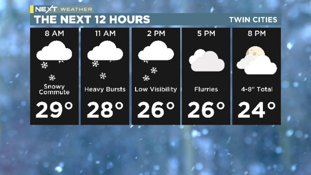
MINNEAPOLIS — Tuesday is a NEXT Weather Alert day due to a high-impact snow event that could affect both the morning and evening commutes in the Twin Cities.
As of 5 a.m., snow was already falling in southwestern and south central Minnesota. The storm was expected to make its way to the metro before the morning commute.
MORE: WCCO’s NEXT Weather homepage
A winter storm warning is in effect for areas stretching from Mankato through the Twin Cities and into Wisconsin. That band could see anywhere between 4 and 8 inches in total.

CBS News
A winter weather advisory is in effect for other parts of central and southern Minnesota, as well as western Wisconsin.
Southeastern Minnesota could see a wintry mix.
The snow was expected to move out of Minnesota after the evening commute.
CBS News
The metro had already reached its high temperature in the morning hours, and it’ll only get colder throughout the day. Wednesday will also be chilly, and quite windy.
Temperatures will rebound on Friday and some of the snow will melt, but we’ll have another cold snap over the weekend.
Our next shot at snow comes early next week.