Tag Archives: Nor'easter

N.J. weather: Flash flood watch expands to 17 counties. Nor’easter could dump up to 4 inches of rain.

A flash flood watch for New Jersey has been extended to 17 counties as the state braces for a nor’easter storm with severe thunderstorms and damaging winds that could deliver up to 4 inches of rain between Monday night and Tuesday afternoon.

The nearly statewide flash flood watch (all counties except Camden, Cumberland, Gloucester and Salem) runs from 8 p.m. Monday until 5 p.m. Tuesday, the National Weather Service said. It’s still expected to rain in the South Jersey counties not under the watch, though.

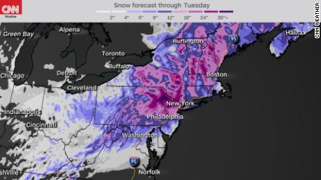
About 2.5 to 3.5 inches of rain is expected in a large chunk of the state, which could lead to flash flooding of creeks, streams, urban areas and areas with poor drainage.

From 2 to 4 inches of rain are likely to fall across New Jersey from Monday night through Tuesday, Oct. 26, 2021.National Weather Service

Monday should be mainly dry with most of the rain falling from late Monday night through much of the day Tuesday, the weather service said in its morning forecast discussion. Some showers could move in late this afternoon, though.

Severe thunderstorms are possible Monday night with damaging winds that could pull down trees and power lines, leading to outages. The heaviest wind gusts — up to 45 mph — are likely Tuesday night along the Jersey Shore.

A nor’easter storm is expected to slam New Jersey with severe thunderstorms, high wind and heavy rain with accumulations up to 4 inches Monday night and into Tuesday.

Forecasters caution that a slight shift in the track of the storm could significantly impact rain totals. If the low moves closer to the Shore, it might mean more rain, while if the system slides further from the coast, impacts would likely be lesser.

Minor coastal flooding is expected along the Jersey Shore and the Delaware Bay from Tuesday morning through Thursday morning. Just spotty minor flood is likely along the Delaware River from Trenton south.

Meanwhile, most of Monday will be cloudy and mild as highs climb into the low 70s to mid 70s — 10 to 15 degrees above normal for later October. Lows will be in the 50s tonight before temps reach the low 60s Tuesday when the bulk of the rain falls. We’ll dry out Wednesday, though it will be cloudy. The sun is expected to return Thursday with highs in the low 60s.

Jeff Goldman may be reached at jeff_goldman@njadvancemedia.com.

Our journalism needs your support. Please subscribe today to NJ.com.

Read original article here

‘Bomb Cyclone,’ nor’easter and other severe weather will unfold this week across the US

From “bomb cyclones” to severe weather and nor’easters, this week has it all.

As a “bomb cyclone” ramps up a firehouse of heavy rain across the West, new evacuation orders have been issued for vulnerable locations near recent burn scars.
Santa Barbara County officials upgraded the recent evacuation warning to an evacuation order for parts of the Alisal Fire burn area. Concerns are mounting about dangerous debris flows to develop as heavy rain is forecast to fall over the recently scorched earth.

Evacuation orders mean that it is unlawful to remain in place, with an immediate threat to life and property.

The threats associated with this atmospheric river don’t stop there. Several feet of snow are forecast for the Sierra Nevada mountain range creating nearly impossible driving conditions, according to the National Weather Service (NWS) office in Hanford, California.

Expect major travel delays as chain controls and roadway closures are likely to be enforced. The most intense snowfall will occur Sunday night into Monday and will be heaviest at elevations above 5,000 feet.

Strong winds gusting over 50 miles per hour will accompany the heavy, wet snow.

The NWS has flash flood watches across a large expanse of central and northern California. Rainfall accumulations of 3 to 6 inches, with locally higher amounts exceeding 10 inches, will lead to localized flash flooding, mudslides and rockslides.

Particularly vulnerable roadways and streams are most at risk with this event, as the heavy rain is forecast to last into Monday.

Significant tornado outbreak possible Sunday

Severe weather is possible early this week for a large part of the country.

A temperature battleground is setting the stage for an outbreak that will begin Sunday across the mid Mississippi Valley and move east to the Carolinas and mid-Atlantic states by Monday.

Tornadoes, large hail and damaging winds are all possible Sunday across parts of Arkansas, Missouri, Illinois and Indiana.

However, the Storm Prediction Center has highlighted a specific area from St. Louis to Springfield, Missouri, as having a significant threat for tornadoes. This region has a greater than 10% probability of a strong tornado (EF-2 to EF-5) within 25 miles of any particular point.

Fall is commonly considered a secondary peak season for severe weather in the US.

Large temperature swings associated with the changing seasons can help fuel severe weather development. Even though tornadoes can occur anytime of the year, fall typically experiences an uptick in activity as warm, humid air from the south interacts with increasingly more potent cold fronts from the north.

Weather models hint at possible nor’easter midweek

The same energy associated with the severe weather outbreak will translate to a powerful low pressure system known as a nor’easter along the East Coast of the US by Tuesday and Wednesday.

Conditions are looking favorable for strong northeasterly winds to develop, which is how a nor’easter gets its name. Coastal flooding and heavy rain are also possible across southern New England.

Specific forecast details are still unknown, as this event is still several days away, but the potential exists for urban and street flooding. Some computer models predict more than 6 inches of rain for the region.

As the autumn leaves are still yet to fall across much of New England, gusty winds could easily topple trees and branches. This may potentially lead to power outages across the region.

Read original article here

NYC Weather: More snow expected as marathon nor’easter slams New York City and the Tri-State

NEW YORK (WABC) — More snow is expected to fall Tuesday across the Tri-State area after New York City experienced its snowiest day in five years while parts of New Jersey topped 2 feet.

More than a foot of snow fell in Central Park Monday, in a snow storm that made the top 20 for New York City and one of the biggest ever for parts of northern New Jersey.

The relentless storm piled on 3 inches of snow an hour at times while wicked wind gusts caused blowing snow that limited visibility and drifts that buried parked cars to their windows.

RELATED: Snowfall totals around New York and the Tri-State area

The same areas that were hit hard earlier Monday will tack on even more snow — including areas of Northern Jersey, Westchester and Rockland County.

Meteorologist Lee Goldberg says expect waves of light to moderate snow Tuesday. It’ll start out as an early morning mix and then be met by colder air that turns into snow Tuesday evening through Wednesday morning.

Blowing and drifting will continue as winds stay gusty in the 30-35 mph range. The event could well last 48 hours, making it a rare snowstorm the likes of which we see every five to 10 years, ABC7 meteorologist Jeff Smith said.

Before it’s over, parts of New York City could see 18 inches of snow, with even higher amounts to the north and west as the heaviest snow shifts in that direction.

RELATED: School closings for New York, New Jersey and Connecticut

The winter storm warning continues on Tuesday as the storm slowly pulls away. It’ll still be blustery and chilly. Additional significant accumulation is not likely during the day Tuesday, but don’t be surprised to see a few more inches before the storm finally departs.

The snow itself will likely remain fluffy throughout the event, because it’s so cold, but could become wetter and heavier in coastal airs that see mixing.

Coastal areas will also have to contend with the risk of flooding from the powerhouse storm, with flood warnings in effect on Long Island until 3 a.m. Tuesday. These areas face a risk of moderate coastal flooding, but some areas could see major flooding.

There were also concerns that high tide could bring widespread moderate to isolated major flooding in vulnerable areas, areas like Freeport and Lindenhurst on Long Island and the South Shore back bays. The storm’s slow-moving nature will encompass several high-tide cycles, adding to the concerns.

RELATED: Live winter storm updates from around the Tri-State

Stay with the AccuWeather team for continuing updates.

SEND YOUR SNOW PHOTOS HERE:

ADDITIONAL WINTER STORM COVERAGE

Winter Storm Warnings issued by the National Weather Service
Snow Stream live winter storm updates
New York CIty declares state of emergency
Mass transit and travel information
Check AccuTrack Radar
School closings and delays

For weather updates wherever you go, please download the AccuWeather app.

Copyright © 2021 WABC-TV. All Rights Reserved.


Read original article here

Major Nor’easter affecting Northeast with possible historic snow in NYC

Millions across the Northeast are waking up Monday to the year’s first major winter storm with up to 2 feet of snow projected and blizzard-like conditions expected across the region.

The National Weather Service warned that widespread heavy snow of one to two feet is forecast from Pennsylvania into New England including Philadelphia, New York City and Boston through Tuesday, with snowfall rates reaching up to two inches an hour.

NBC News meteorologist Bill Karins said the Tri-State area could see its biggest snowstorm in five years, while New York City could get between 12 and 16 inches of snow, with up to 20 inches possible if one of the heavy snow bands sits over the city Monday afternoon.

Karins said the National Weather Service’s New York office forecast has called for 21 inches in Central Park, which would tie it for the fourth largest snowstorm in New York City’s history.

Periods of light snow will continue on and off through early Tuesday, he added.

The National Weather Service warned that travel conditions will be “difficult to impossible” across the northeast.

The Maryland State Patrol said Monday morning they answered almost 900 calls and responded to 330 crashes and about 150 disabled or unattended vehicles on Sunday.

New York Mayor Bill de Blasio said during a Sunday news conference that schools would be closed on Monday and that officials are rescheduling appointments for coronavirus vaccinations.

“The last thing we want to do is urge our seniors to come out in the middle of a storm like this,” de Blasio said, warning residents not to underestimate weather conditions.

The mayor also tweeted that nonessential travel will be restricted in New York City starting at 6 a.m. Monday as part of a local state of emergency.

“This winter storm will be dangerous with heavy snowfall and strong winds,” de Blasio said. “If you can stay home, stay home.”

Among other states that closed major coronavirus vaccine sites are Rhode Island, New Jersey and Connecticut.

The John F. Kennedy Airport and the Newark Liberty International Airport have canceled a total of more than 300 flights, or about 75 percent. LaGuardia Airport topped the list with 90 percent of its flights canceled on Monday.

Download the NBC News app for breaking news and politics

The storm had already blanketed parts of the Midwest in the most snow some places had seen in several years. Chicago got almost 7 inches of snow by Sunday morning. In Wisconsin, snow depths in some counties near Lake Michigan had reached more than 15 inches.

Snow also hit the Washington metropolitan area, with over two inches reported in several areas, but another round of snow is possible Monday morning. The city’s inclement weather prompted President Joe Biden to postpone a visit to the State Department that had been planned for Monday, a White House official told NBC News.


Read original article here

NYC Weather: Nor’easter bears down with heavy snow, strong winds across NYC, NJ and the Tri-State area

NEW YORK (WABC) — A major nor’easter that threatens to dump as much as 2 feet of snow on parts of the Tri-State area over the next two days has moved into the region.

A one-two punch of strong winds and heavy snow has the potential to produce blizzard-like conditions in the Tri-State area on Monday as the biggest winter storm in years wallops the region.

The brunt will come on Monday with 1 to 2 inches an hour of snow or even higher along with 40-50 mph wind gusts. Some areas could even experience thunder snow at the storm’s peak.

Snow tapers off Tuesday but blowing and drifting will continue as winds stay gusty.

The event could well last 48 hours, making it a rare snowstorm the likes of which we see every five to 10 years, ABC7 meteorologist Jeff Smith said.

RELATED: School closings for New York, New Jersey and Connecticut

ALERT: Winter Storm Warnings issued by the National Weather Service

Sunday evening, New York City looked like a snow globe from roof cameras as visibilities quickly decreased.

With states of emergencies declared for New Jersey and New York City, a coating of snow was in place in the five boroughs by early evening, and parts of New Jersey already had several inches, with the storm only a few hours into its assault on the region.

When all is said and done, the metropolitan area could see dramatic extremes in accumulations, with 18 to 24 inches possible in northwestern New Jersey – as close to the city as northwestern Bergen County – and southern parts of the Catskills.

That pocket of intense snow accumulation could inch closer toward the city depending on the extent to which the storm remains all snow closer to the coast. Coastal areas could see a mix of precipitation if temperatures manage to rise above freezing later in the day on Monday, as the slow-moving storm drags in milder air off the Atlantic Ocean.

Right now, northeastern and central New Jersey, New York City, western Nassau County, the Hudson Valley and nearby Connecticut are all in the bullseye for a solid foot to 18 inches of snow.

Eastern Nassau and western Suffolk counties are in the 6″-12” range, and the twin forks of Long Island, along with South Jersey, could see just 3”-6”, with mixing and warmer air.

The strongest of the winds will be along the coast and across Long Island. It is coastal areas and the city itself that could potentially see blizzard-like conditions for a time, but the National Weather Service has not issued such a warning. For now, the entire region remains under a Winter Storm Warning.

The storm slowly departs on Tuesday, but it’ll still be blustery and chilly. Additional significant accumulation is not likely during the day Tuesday, but don’t be surprised to see a few more inches before the storm finally departs.

The snow itself will likely remain fluffy throughout the event, because it’s so cold, but could become wetter and heavier in coastal airs that see mixing.

Coastal areas will also have to contend with the risk of flooding from the powerhouse storm, with flood warnings in effect on Long Island until 3 a.m. Tuesday. These areas face a risk of moderate coastal flooding, but some areas could see major flooding.

High tide Monday night could bring 2 1/2 to 3 1/2 feet of inundation in vulnerable areas, areas like Freeport and Lindenhurst on Long Island and the South Shore back bays. The storm’s slow-moving nature will encompass several high-tide cycles, adding to the concerns.

RELATED: Live winter storm updates from around the Tri-State

Stay with the AccuWeather team for continuing updates.

SEND YOUR SNOW PHOTOS HERE:

ALSO READ | Snowy Owl in Central Park gives visitors once in a lifetime sight

MORE ACCUWEATHER RESOURCES
Check AccuTrack Radar

School closings and delays

RELATED: “Rising Risk” docuseries explores how those rising sea levels will play out in the lower Manhattan of the late 21st century. Watch now on our CTV apps for Fire, Roku, Apple TV and Android TV

For weather updates wherever you go, please download the AccuWeather app.

Copyright © 2021 WABC-TV. All Rights Reserved.


Read original article here

As the Midwest digs out, the East Coast braces for a powerful nor’easter

It’s been almost two years since Washington, DC has had a snowfall greater than 1 inch, but that could change drastically by later Sunday. The city is under a winter storm warning through Sunday evening, with 4-8 inches of snow possible. Additional snow will likely fall on Monday.

“Forecasting snowfall amounts in the nation’s capital is rarely easy, but confidence is increasing that the DC area will see a significant snowfall developing on Sunday and lasting into Monday,” says CNN meteorologist Taylor Ward.

A big winter storm is in the works that could bring the nation’s capital as much as 10 inches of snow. This would end the 709-day streak that Washington, DC has gone without a snowfall greater than 1 inch.

“The only other time this has happened was a 788-day streak that ended in 2013,” says CNN meteorologist Brandon Miller.

The storm’s path

On Sunday morning, more than 100 million people were under winter weather alerts from the southern Great Lakes to New England. The storm’s impacts have already been felt as heavy snow fell across northern Illinois and central Indiana, causing travel headaches.

The storm will strengthen into a powerful nor’easter by Monday morning as it reaches the coast. This will be a long duration event for many along the eastern seaboard as the system will be slow to exit. Snow will fall in periodic bursts over the next three days from DC, Philadelphia, New York City to Boston, ending gradually from the southwest to the northeast.

Major impacts expected

Strong winds will accompany the heavy snow, reducing visibility and creating power outages. Travel disruptions will be extensive from the ground to the air as the storm coats roads and runways with fresh snow. Snowfall rates of 1-2 inches per hour were reported near Chicago’s suburbs late Saturday evening, where up to 9 inches of snow is forecast by Sunday night. As the storm moves east, it will reorganize and intensify. The highest snow accumulations will occur from New Jersey to southern New York, eastern Pennsylvania and parts of Maryland, where up to a foot of snow is possible.

Ice and sleet accumulation is also a concern for portions of North Carolina, Virginia, Maryland and West Virginia. The highest totals will likely fall north of Charlotte and Raleigh where up to 1/2 inch of ice is possible.

The warm sector of this storm is creating numerous showers and embedded thunderstorms across the central and southeastern US today. Expect a rainy Sunday in Atlanta before showers exit the region by the start of the work week.

Areas farther west such as St. Louis and Springfield, Illinois, will see more of a rain/snow mix through Sunday evening. Exactly how much snow will stick to the ground remains uncertain.

One week after areas of Iowa were pummeled by snow, the Hawkeye State could see a few additional inches by Sunday night.

A developing nor’easter

“Snow will move in from southwest to northeast late Saturday night and early Sunday morning, with snow likely widespread by mid-late morning Sunday,” said the National Weather Service office in Baltimore and Washington, DC.

By Sunday afternoon into Monday, there is the potential of a changeover to sleet and freezing rain.

With any nor’easter, there is uncertainty in the forecast snow totals because so much depends on the exact track of the low pressure.

“There seems to be a consensus amongst forecast models that moderate to heavy snow will occur from portions of Virginia to Pennsylvania and New Jersey, but there continues to be some uncertainty on the exact track of the low pressure Monday into Tuesday,” Ward said. “This will have a significant impact on how much snow falls from New York City into New England. A storm system that tracks parallel to the coast would provide greater snowfall, while a more eastward track out to sea would limit snow totals in New England.”

That could make the difference in places like Boston and New York City between seeing 4 inches of snow or a foot.

Philadelphia’s NWS office is forecasting more than 6 inches of snow with gusts of wind as high as 45 mph “creating significant blowing and drifting snow.”

In its forecast discussion, the office also noted that the storm is forecast to be an abnormally long event, with 36 or more hours of snow and wintry precipitation, and that the highest snow totals and rates will likely not be realized until late Monday.

The NWS office in Boston had already hinted Friday at the storm and its possible effects.

“There is the potential for a significant winter storm later Mon into Tue,” the Boston office said on Twitter. “If this storm materializes significant snow accumulations would be possible for some along with a period of strong winds & coastal flooding along the eastern MA coast.”

The storm will then push off the coast by Wednesday.

CNN’s Jennifer Gray contributed to this report.


Read original article here

Winter Storm For Susquehanna Valley Sunday & Monday

WINTER STORM WARNING FOR THE SUSQUEHANNA VALLEY 3 AM SUNDAY TO 5 AM TUESDAYThe Susquehanna Valley should prepare for an impactful winter storm starting late Sunday morning, continue through Monday, then end early Tuesday morning. The Susquehanna Valley could see moderate to heavy snow at times, especially late Monday morning through Monday evening if conditions are favorable and a developing coastal low sets up in the right spot. High pressure centered over the region will keep weather cold and quiet for Saturday night. Temperatures fall to the lower 20s to upper teens for our overnight lows. Cloud cover from the approaching storm moves in from the southwest by dawn Sunday morning. The snow is expected to fall in two waves. The first wave of snow for us will start to fall late Sunday morning to early Sunday afternoon while the storm is moving across the Ohio River Valley. Temperatures will be in the mid 20s in the morning and then only rise to around 30 degrees by the mid afternoon. Steady light snow is expected through much of Sunday afternoon and early evening. By dusk, snowfall totals could be between 2 to 4 inches across the Valley. Be prepared for minor travel disruptions starting early Sunday afternoon and intensify through the early evening. The Ohio Valley storm will then begin to transfer its storm energy to a developing coastal storm Sunday night. As it does so, there may be a lull in the snowfall. Also, because of a more northerly track of the Ohio Valley storm, some warmer air may mix into the storm at cloud level. This could allow for a changeover from all snow to a wintry mix of snow/sleet/and rain for areas along and south of the Pennsylvania Turnpike (I-76). This switch over may glaze over some roads Sunday night into early Monday morning, making travel more difficult. It may also greatly impact our snowfall forecast totals. If we see more of a mix, or less intense precipitation, our overall snowfall totals may be lower. Our second wave of snow arrives Monday. By dawn Monday, the coastal storm will have fully developed and begin to head northward or northeastward. The bulk of our snow is expected to fall from late Monday morning, through the afternoon and early evening hours. Where this storm is located off the East Coast will have a huge role on just how much snow we could see through the day Monday. A 50 mile shift in track could mean the difference between seeing just a few inches of snow or possibly upwards of a foot of snow. Right now the current WGAL News 8 Storm Team believes much of the Susquehanna Valley should prepare for at least a plowable snow and possibly upwards of a foot of snow by Monday night. There is also some indication that there could be prolonged heavy snowfall in a few narrow bands due to the way the storm is forecast to be positioned off the East Coast. Where these heavy bands set up is yet to be determined. There is still a chance the storm could stay far enough out to sea drier air gets pulled into the storm and the storm shuts down completely earlier in the day Monday. There are a lot of moving parts and with this forecast, so please check back frequently for more updates through the weekend. The snow tapers and ends Monday night into Tuesday, but some light additional snowfall is possible. This snow is expected to be lighter, fluffier than the snow that falls for most of Monday, so some minor drifting is possible for travel late Monday night into Tuesday. Highs Tuesday will be in the lower 30s.Extended forecast:Wednesday: Partly sunny. High: 38. Thursday: Partly sunny. Chance of few snow showers late. High: 40. Friday: Mostly cloudy. Chance of rain/snow. High: 44. Saturday: Partly sunny. High: 40.

WINTER STORM WARNING FOR THE SUSQUEHANNA VALLEY 3 AM SUNDAY TO 5 AM TUESDAY

The Susquehanna Valley should prepare for an impactful winter storm starting late Sunday morning, continue through Monday, then end early Tuesday morning. The Susquehanna Valley could see moderate to heavy snow at times, especially late Monday morning through Monday evening if conditions are favorable and a developing coastal low sets up in the right spot.

High pressure centered over the region will keep weather cold and quiet for Saturday night. Temperatures fall to the lower 20s to upper teens for our overnight lows. Cloud cover from the approaching storm moves in from the southwest by dawn Sunday morning.

The snow is expected to fall in two waves. The first wave of snow for us will start to fall late Sunday morning to early Sunday afternoon while the storm is moving across the Ohio River Valley. Temperatures will be in the mid 20s in the morning and then only rise to around 30 degrees by the mid afternoon. Steady light snow is expected through much of Sunday afternoon and early evening. By dusk, snowfall totals could be between 2 to 4 inches across the Valley. Be prepared for minor travel disruptions starting early Sunday afternoon and intensify through the early evening.

The Ohio Valley storm will then begin to transfer its storm energy to a developing coastal storm Sunday night. As it does so, there may be a lull in the snowfall. Also, because of a more northerly track of the Ohio Valley storm, some warmer air may mix into the storm at cloud level. This could allow for a changeover from all snow to a wintry mix of snow/sleet/and rain for areas along and south of the Pennsylvania Turnpike (I-76). This switch over may glaze over some roads Sunday night into early Monday morning, making travel more difficult. It may also greatly impact our snowfall forecast totals. If we see more of a mix, or less intense precipitation, our overall snowfall totals may be lower.

Our second wave of snow arrives Monday. By dawn Monday, the coastal storm will have fully developed and begin to head northward or northeastward. The bulk of our snow is expected to fall from late Monday morning, through the afternoon and early evening hours.

Where this storm is located off the East Coast will have a huge role on just how much snow we could see through the day Monday. A 50 mile shift in track could mean the difference between seeing just a few inches of snow or possibly upwards of a foot of snow. Right now the current WGAL News 8 Storm Team believes much of the Susquehanna Valley should prepare for at least a plowable snow and possibly upwards of a foot of snow by Monday night. There is also some indication that there could be prolonged heavy snowfall in a few narrow bands due to the way the storm is forecast to be positioned off the East Coast. Where these heavy bands set up is yet to be determined. There is still a chance the storm could stay far enough out to sea drier air gets pulled into the storm and the storm shuts down completely earlier in the day Monday.

There are a lot of moving parts and with this forecast, so please check back frequently for more updates through the weekend.

The snow tapers and ends Monday night into Tuesday, but some light additional snowfall is possible. This snow is expected to be lighter, fluffier than the snow that falls for most of Monday, so some minor drifting is possible for travel late Monday night into Tuesday. Highs Tuesday will be in the lower 30s.

Extended forecast:

Wednesday: Partly sunny. High: 38.

Thursday: Partly sunny. Chance of few snow showers late. High: 40.

Friday: Mostly cloudy. Chance of rain/snow. High: 44.

Saturday: Partly sunny. High: 40.

Read original article here