Watch the latest forecast in the player above.The first wave of snow and winter weather in the WLKY viewing area is lingering, but a more impactful round two bringing big accumulation will move in this afternoon.A winter storm warning remains in effect through 1 p.m. on Tuesday afternoon.This storm has the potential to be one of our biggest winter storms in several years. Interactive radar | Closings, delays Many areas saw about an inch or so of snow Monday morning. Some flurries will linger on for another coating. The second big batch of wintry precipitation comes later Monday afternoon. TIMELINE: WLKY’s Matt Milosevich recommends wrapping up plans by 2 or 3 p.m.By Tuesday morning, snow totals of 6 or more inches will be common. Some places in the northwest of our area have the chance to hit as much as 12 inches. The projection for Louisville is 6 to 8 inches.The areas in the southeast part of the viewing area could see more sleet than snow, so their snow totals could be much lower, more like 1 to 4 inches. The storm will wrap up by the end of Monday into early Tuesday — drier skies return Tuesday afternoonAs for temperatures, it feels like its in the single digits Monday morning and the cold will keep that snow and ice around for awhile.Officials have been advising people to stay off the roads in the next couple of days.Wednesday night into Thursday could bring yet another winter storm. Temperatures finally get above freezing on Sunday.Stay up to date on this forecast right here.
Watch the latest forecast in the player above.
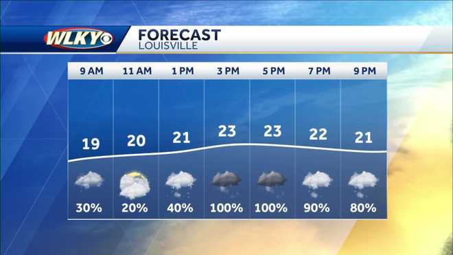
The first wave of snow and winter weather in the WLKY viewing area is lingering, but a more impactful round two bringing big accumulation will move in this afternoon.
A winter storm warning remains in effect through 1 p.m. on Tuesday afternoon.
This storm has the potential to be one of our biggest winter storms in several years.
Interactive radar | Closings, delays
Many areas saw about an inch or so of snow Monday morning. Some flurries will linger on for another coating. The second big batch of wintry precipitation comes later Monday afternoon.
TIMELINE:
WLKY’s Matt Milosevich recommends wrapping up plans by 2 or 3 p.m.
By Tuesday morning, snow totals of 6 or more inches will be common. Some places in the northwest of our area have the chance to hit as much as 12 inches. The projection for Louisville is 6 to 8 inches.
The areas in the southeast part of the viewing area could see more sleet than snow, so their snow totals could be much lower, more like 1 to 4 inches.
The storm will wrap up by the end of Monday into early Tuesday — drier skies return Tuesday afternoon
As for temperatures, it feels like its in the single digits Monday morning and the cold will keep that snow and ice around for awhile.
Officials have been advising people to stay off the roads in the next couple of days.
Wednesday night into Thursday could bring yet another winter storm. Temperatures finally get above freezing on Sunday.
Stay up to date on this forecast right here.


