The busy end of 2022 continues into the start of 2023, as another winter storm is moving across the Midwest. Snow is likely across the Twin Cities Monday night through Tuesday. Ice accumulations are likely south of the metro through the I-90 corridor.
WARNINGS
A Winter Storm Warning is in effect from southwest Minnesota through the Twin Cities metro, and into western Wisconsin. This begins Monday afternoon and continues through Tuesday evening. An Ice Storm Warning is in effect in southern Minnesota from Monday afternoon through Tuesday evening. A few counties in central Minnesota and western Wisconsin are under a Winter Weather Advisory Monday evening through Tuesday evening.
TIMELINE
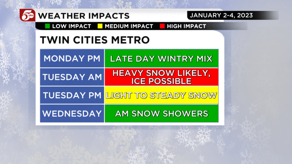
Some scattered snow showers are possible on Monday afternoon, mainly from the Twin Cities to the south. In southern Minnesota, there could be some freezing drizzle mixing with the snow. Any precipitation would be very light through about 6:00 p.m. Monday.
Starting Monday evening, snow will become widespread in the Winter Storm Warning through Monday night. This is also when freezing rain is likely along the I-90 corridor. Most ice accumulations will be between sunset Monday and sunrise Tuesday.
Heavy snow is likely in the Twin Cities metro Tuesday morning, then taper to lighter snow in the afternoon. On and off light snow showers continue Tuesday night, finally coming to an end Wednesday morning.
SNOW AND ICE TOTALS
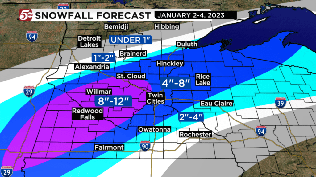
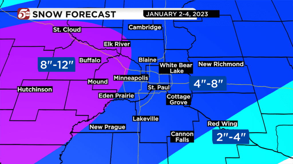
The heaviest snow is likely from southwest Minnesota into the west metro. 8 to 12 inches are possible in these areas. The south and east metro totals could be anywhere from 4 to 8 inches. Any freezing rain mixing in could keep snow totals on the lower end of that range. There will be a sharp cut-off on the north and south side of the heaviest snow. Totals could be over 8 inches in St. Cloud, then only an inch or two around Brainerd.
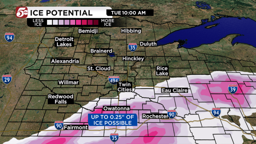
Ice accumulations could be significant in parts of southern Minnesota. Up to 0.25″ of ice is possible from Owatonna to Rochester, south into Iowa. As always, ice can make driving very difficult to dangerous at times, but it can also cause power outages. If you are in the Ice Storm Warning, keep this in mind as you prepare for the storm.
WHAT COULD STILL CHANGE?
The forecast confidence is high for heavy snow in southwest Minnesota. There is also high confidence in ice accumulations closer to the I-90 corridor. The difficult part of this forecast is where the change from freezing rain to snow will happen. This is why snow totals in the Twin Cities could still change as we get closer to Tuesday. Regardless, any combination of snow and ice will still be disruptive Monday night through Tuesday.
HOW TO PREPARE
Start thinking about limiting travel on Tuesday, especially if you were planning on driving through southern or southwestern Minnesota. If you have an appointment scheduled, consider rescheduling. Even skilled winter drivers would have problems with this much ice.
Parents, have a plan if kids need to stay home from school on Tuesday.
If you have the time on Monday, make sure you have gas for the snowblower, and that you have enough sand and/or salt.
FORECAST UPDATES
Minnesota’s Weather Authority will continue to update the forecast before the storm on Monday and will take you through it on Tuesday. You can always get the latest updates on KSTP.com and the KSTP Mobile App.