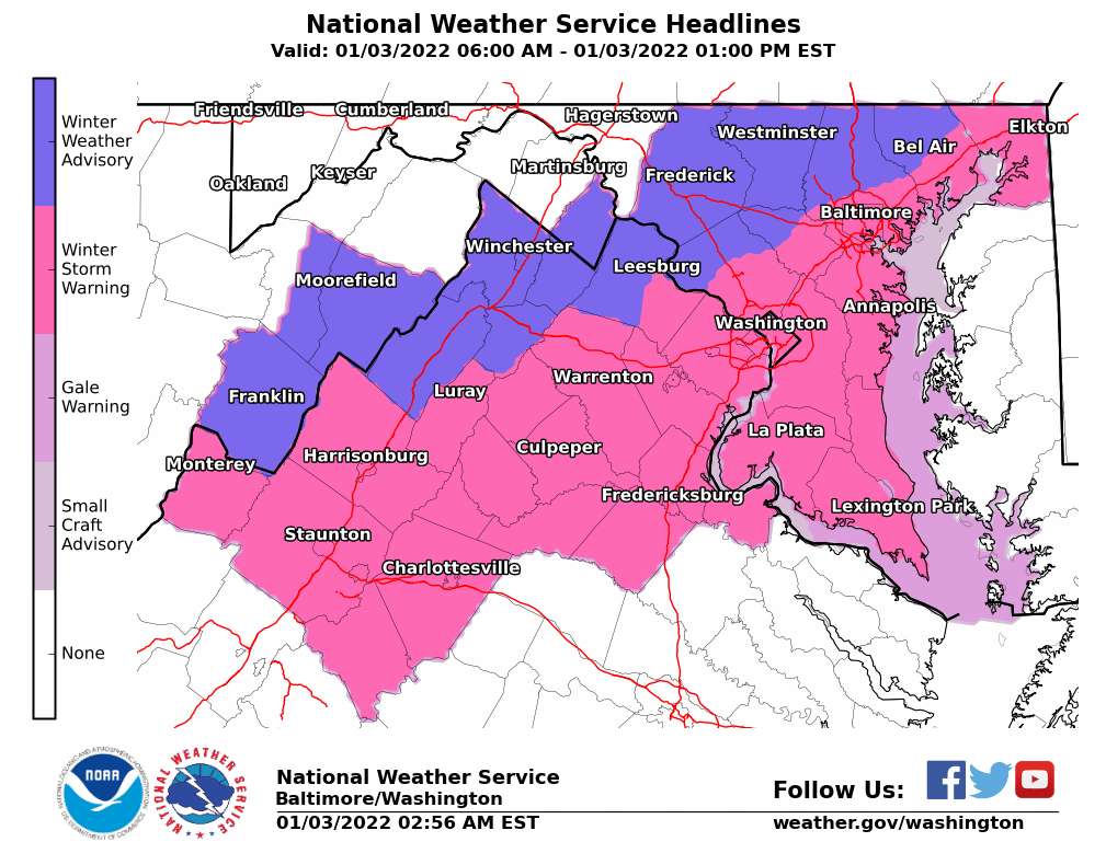
The D.C. metro region is hunkered down for its first accumulating snowfall of the season, and it’s poised to be a big one. Snow is falling across the region. A Winter Storm Warning continues for much of the region until 4 p.m. Between 5 and 10 inches are possible in D.C. and Baltimore.
Key points:
- A Winter Storm Warning continues for much of the Washington and Baltimore metropolitan area until 4 p.m. Monday.
- Totals: Between 5 and 10 inches in D.C. and Baltimore, with 1 to 4 inches in northern and western suburbs and higher amounts possible south and east.
- The heaviest snow will fall between daybreak and late morning.
- Federal offices and most public school districts are closed. See WTOP’s full list of closures and delays.
It took a while, but winter is finally here in earnest: The D.C. metro region is hunkered down for its first accumulating snowfall of the season, and it’s poised to be a big one.
Between 5 and 8 inches are likely by Monday afternoon for millions from D.C. to Baltimore. Those who hadn’t transitioned from a wintry mix to all snow as of 7 a.m. will soon, and forecasters expect bands of heavy snow to develop and intensify over the next few hours.
A Winter Storm Warning is in effect for the Washington and Baltimore metro areas. Those living near or south of Interstate 66 and U.S. Route 50 will see the heaviest snow fall from mid- to late morning with the forecast calling for up to 10 inches. Points north and west, including parts of Loudoun County in Virginia and Montgomery and Howard counties in Maryland, are under a Winter Weather Advisory for more modest totals of 3 to 5 inches.
Driving will be treacherous, especially within heavier bands. Plan on slippery conditions and visibility below one-half mile. If you must head out Monday, drive slowly, make way for plows and use caution on steps, sidewalks, driveways and streets. Beware of roads refreezing Monday evening into Tuesday morning.
Computer models continued nudging the storm’s path to the north overnight, bringing D.C. and Baltimore proper under the bullseye for a major winter weather event. Snowfall rates of at least an inch an hour are possible in the WTOP listening area from 7 a.m. to 11 a.m. as the storm rapidly deepens over the Carolinas.
But while the odds of a significant event have trended upward for urban areas, uncertainty remains over how far north into the suburbs the worst will make it. Forecasters are eyeing a sharp gradient at the storm’s northern edge, and any last-minute nudges could mean a big difference in totals for Central Maryland and parts of Northern Virginia.
The precise setup of heavier snow bands are also notoriously difficult to predict, and that too could be a determining factor.
“This is a type of storm that is going to be on the coast and there’s going to be a tight gradient between where the precipitation falls and where there’s going to be nothing,” Storm Team 4 meteorologist Ryan Miller said.
Mass transit and traffic
Metrobus is running on a severe snow service pattern for Monday. Buses will operate on major roadways only, with most lines that normally run on Sundays remaining in service — see a full list of impacted routes. Buses may be delayed on a line-by-line basis; riders should consider Metrorail as an alternative.
Virginia Railway Express trains are operating on an S schedule. Maryland’s MARC commuter trains will run an enhanced R timetable. MTA Express BusLink routes, along with LocalLink routes 38, 57, and 92, will not operate.
Responses from the region
Transportation officials in Maryland and the District spent the overnight prepping their plows and salt supplies — but staffing shortages due to surging coronavirus cases could spell a slower rollout than usual.
Current estimates are that Montgomery County’s plow operators are down by 25% to 30%, but the transportation department does not anticipate issues clearing major streets. The District is about 40 drivers short but has contractors to backfill those positions, said Chris Geldart, deputy mayor for public safety.
D.C. Mayor Muriel Bowser declared a snow emergency and deployed a team of more than 100 snowplows. The city also started treating roads with salt.
In Maryland, crews spent the night loading up on rock salt. Charlie Gischlar, community relations manager with the Maryland Department of Transportation State Highway Administration, said they’ll start by spreading salt on roadways before plowing operations.
Because the storm started as rain, Gischlar said crews couldn’t pretreat the roads effectively: “All the material would just simply wash off the roadway. So now we’re just going to be loaded up and ready to go.”
Ellen Kamilakis, spokeswoman with the Virginia Department of Transportation, said crews there also started mobilizing overnight.
“They get their map assignments as to which area they’re going to be plowing, they get filled with salt or sand depending upon where they’re going to be. And then they go off to wait for the storm to begin,” Kamilakis said.
She added their plows will drop blades down and actually start to push the snow once there are two inches of accumulation on the ground.
Forecast:
Monday: A mix of snow, sleet and rain, becoming all snow around daybreak. Snow ends by late afternoon. Windy. Temperatures falling to near 30.
Monday night: Clear with winds diminishing. Frigid. Lows in the mid teens to near 20.
Tuesday: Sunny. Highs in the upper 30s to low 40s.
Wednesday: Becoming cloudy. Highs in the mid to upper 40s.
Thursday: Mostly cloudy. Highs in the low to mid 40s.