LATEST Dec. 2, 9:43 a.m.
The University of California, Berkeley Central Sierra Snow Lab located in Soda Springs off Interstate 80 said it has recorded 19.7 inches of snow since a cold front swept Northern California on Wednesday and dumped heavy snow in the Sierra on Thursday.
Conditions were calm in the Tahoe Basin area on Friday morning, but the lab, which is located at about 6,700 feet elevation, said more snow is expected Saturday through Monday, with a second cold front on the way. The lab is expecting another 18 to 36 inches with the second storm.
Palisades Tahoe said it measured 21 inches of snow.
Dec. 1, 11:13 p.m.
Interstate 80 has reopened in both directions from the Nevada state line to Alta, CHP Truckee tweeted Thursday night.
CHP Truckee said, however, that big rigs are still being turned back.
South Lake Tahoe is blanketed in snow on Nov. 8, with a winter storm warning in effect for Lake Tahoe and Nevada mountains.
Anadolu Agency/Anadolu Agency via Getty ImagesDec. 1, 3:45 p.m.
Interstate 80 is now closed, from Alta, about 30 miles northeast of Auburn, to the Nevada state line “due to high winds and low visibility over Donner Summit,” CHP Truckee posted on Twitter. The agency is turning drivers away in both directions, though Truckee residents will be allowed through with identification.
“PLEASE do not travel on I-80 in the Sierra today unless you absolutely must,” Caltrans warned.
Currently, there is no estimated time for when the highway will reopen.
Dec. 1, 12:45 p.m.
The California Highway Patrol’s Truckee office said Thursday that it was responding to several spinouts and jackknifed big rigs on Interstate 80 as snow covered the highway.
CHP reported a temporary closure at 11:30 a.m. on I-80 in both directions from Boca to Alta due to a jackknifed big rig. I-80 westbound was also shuttered for about an hour at noon due to a similar situation, CHP said.
Snow dumped on California’s Sierra Nevada on Thursday as a cold front swept the region.
The UC Berkeley Central Sierra Snow Lab reported receiving 5.7 inches of snow overnight, and it’s expecting another 20 to 30 inches Thursday and through the weekend, “the perfect start to winter,” the lab wrote on Twitter.
Dec. 1, 7:35 a.m.
Officials warned of dangerous driving conditions and avalanches in California’s Sierra Nevada and Tahoe on Thursday morning as a cold front slammed the mountain range. A second system is expected to push snowfall through the weekend, the National Weather Service said.
“The snow is falling,” said Scott Rowe, a meteorologist with the weather service. “Chain control is happening. We’ve seen a few reports of ski resorts reporting their first couple inches of snow. It’ll pile up as the day goes on. There will be a period in the next few hours with very heavy snowfall rates that will likely happen before 8 a.m. to noon. We’re talking 2 to 4 inches per hour. Today is going to be a really bad travel day.”
An avalanche watch was issued for the Central Sierra, including the Tahoe Basin, on Thursday morning and remains in effect through 7 a.m. Friday. A watch, which advises people to be prepared, is less severe than a warning.
“Heavy snow and gale-force winds will overload the weak snowpack and create very dangerous avalanche conditions,” the Sierra Avalanche Center said. “Widespread, large natural and human-triggered avalanches are very likely in exposed and sheltered terrain at all elevations.”
The center advised people to avoid traveling on, below or near steep slopes.
Officials are warning of dangerous driving conditions across the Sierra through the weekend. Chain control went into effect on Highway 80 between Truckee and Eagle Lakes at 3:15 a.m.
“Back-to-back winter storms will bring periods of very difficult to impossible travel over Sierra passes through Sunday,” the weather service said.
Meteorologists are forecasting heavy snow Thursday with showers tapering off Friday, offering a potential window for travel. Saturday morning is likely to be clear and dry, but a second round of snow is expected to hit that evening and continue into Sunday, the weather service said.
“The main thing that has changed since yesterday is the timing of our winter storm warning,” Rowe said. “Now for the Sierra, the winter storm warning expires tonight [instead of Friday morning]. Most of Friday should be good. Sunday could be a challenging day for folks trying to leave the Sierra.”
The weather service shared cross sections for several well-traveled highways, showing how much snow is expected to pile up at key locations along the roadways Wednesday through Friday.
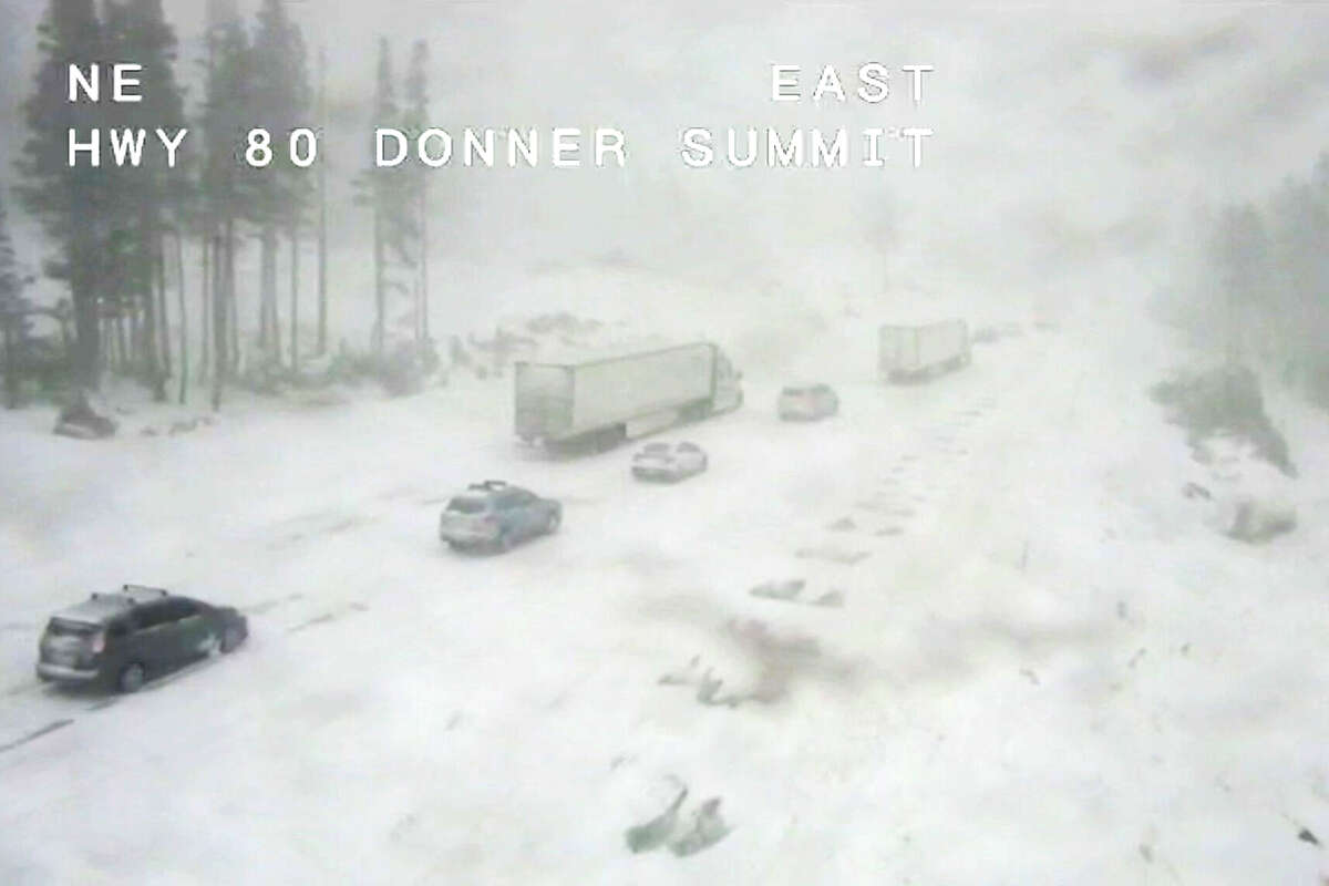
Snow-covered roads on Interstate 80 East Donner Summit via Caltrans CCTV.
CaltransAlong Highway 80, for example, Alta is forecast to measure 6 to 8 inches, Donner Summit 18 to 24 and Truckee 12 to 18. On Highway 120, the Yosemite National Park entrance could record 12 to 18 inches, Tenaya Lake 24 to 30 and Tioga Pass 18 to 24.
The second storm arriving on Saturday is expected to bring another few feet of snow, said Rowe. “The highest elevations may see up to 5 feet combined across both storms,” he said. “At pass level, we’ll see 3 to 4 feet across those two storms.”