Updated 12:30 p.m. Tuesday
The early to mid afternoon hours will see very heavy snowfall in the Twin Cities with one inch per hour or more of snowfall. We’ll then see a break late in the afternoon and early evening before lighter to moderate snow redevelops.
Heavy snow and ice Tuesday; periods of snow into Wednesday night
Some of the heaviest snow will fall between the noon hour and 3 to 4 p.m. in the Twin Cities with up to 1 inch+ per hour rates. Thunder snow is also possible. Radar imagery as of 12:30 p.m. showed a band of very heavy snow and occasional lightning.
Radar imagery as of 12:30 p.m., note lightning as well south of the Twin Cities near Northfield: thunder snow will be possible and very heavy snowfall rates
RadarScope
Winter storm warnings and ice storm warnings are in effect for many areas across central Minnesota into western Wisconsin. In east central Minnesota the winter storm warnings are in effect through 6 p.m. Tuesday and then transition to winter weather advisories as snowfall becomes more light to moderate into Wednesday.

Winter storm warnings, ice storm warnings and winter weather advisories Tuesday and Wednesday
NOAA via pivotal weather
The snow has already been adding up in southwest Minnesota and into South Dakota. totals are exceeding a foot in some places with white out conditions and large drifts.

Snow totals through 10 a.m. Tuesday so far
National Weather Service
Tuesday will bring treacherous travel conditions for southern Minnesota as periods of heavy snow, freezing rain and some wintry mix moves through the area.

Forecast precipitation Tuesday 10 a.m. through Thursday 6 a.m.
College of DuPage Weather
Ice will be of particular concern in south-central and southeast Minnesota Tuesday.
Before you keep reading, take a moment to donate to MPR News. Your financial support ensures that factual and trusted news and context remain accessible to all.
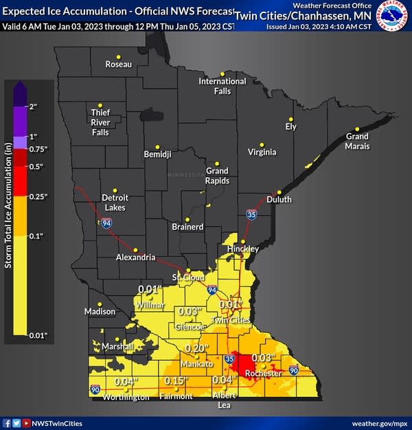
Forecast ice accumulation Tuesday
National Weather Service
The heaviest snow will fall Tuesday into Tuesday night.

Forecast snowfall Tuesday into Tuesday night
NOAA via pivotal weather
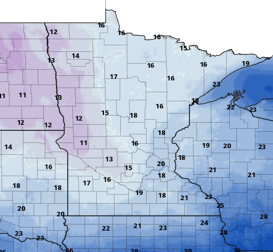
Additional snow will fall Wednesday into Wednesday night making for some impressive totals, especially in southwest Minnesota.

Forecast snowfall totals through midday Thursday
National Weather Service
In addition to the snowfall, winds will be gusty Tuesday into Tuesday night, especially in southwest Minnesota where wind gusts will exceed 40 mph at times.

Forecast wind gusts Tuesday
NOAA via pivotal weather
Colder behind the system Thursday into the weekend
Behind the storm system temperatures cool down but we won’t see an arctic blast like a couple weeks ago. Temperatures will be just slightly below normal Thursday into the weekend.
High temperatures Thursday
NOAA via pivotal weather
Northern Minnesota will see a few subzero nights but lows should stay above zero in southern Minnesota.

Forecast low temperatures Thursday night into early Friday
NOAA via pivotal weather