A strong atmospheric river has landed in California and is bringing heavy rain across the Bay Area on New Year’s Eve. This specific type of atmospheric river is often called a “pineapple express” because of how quickly it helps transport water vapor from Hawaii to the West Coast.
Widespread flooding, mudslides and road closures have already occurred all around region, including water so deep in the Bayshore area south of San Francisco that Highway 101 shut indefinitely in both directions. Wind advisories and ongoing flood watches are in effect as heavy rainfall continues along the coast and snow blankets the Sierra Nevada mountains, according to the NWS.
Latest updates on atmospheric river impact across Northern California:
Oakland’s Lake Merritt overflowing
Stretches of Oakland’s Lake Merritt appeared to be overflowing as the storm continues to batter the Bay Area on Saturday afternoon, according to photos and videos posted on social media. “This is the highest water level I’ve seen at Lake Merritt in years,” tweeted user @bee_oak.
A video posted on Twitter shows portions of the lake’s walking path on the eastern side under water. Other photos show the lake filled to the brim near Harrison Street.
Flooding closes roads in city of Alameda
Crews were setting up barricades Saturday afternoon to close roads due to flooding in the city of Alameda, officials said on Facebook.
The closures affected all of Harbor Bay Parkway, the intersection of Main Street and Willie Stargell Avenue, the intersection of Webster Street and Willie Stargell Avenue, and Brush Street.
Officials urged residents to stay off the roads.
San Francisco rainfall breaks daily all-time record, second-wettest day ever
By noon on Saturday, San Francisco’s rainfall had already broke the daily record for the most ever recorded on New Year’s Eve, the National Weather Service tweeted. The previous record was in 2005, which was 2.12 inches. Saturday had already seen 2.96 inches as of mid-day. Precipitation records in downtown San Francisco go back to 1849. Meteorologist Jan Null tweeted that the rainfall total has now reached the second highest in history for any day. The National Weather Service confirmed that the city has seen 4.78 inches of rain — second only to Nov. 5, 1994, when 5.54 inches were recorded.
Pedestrians with umbrellas cross streets at Columbus Avenue and Stockton Street in San Francisco on Saturday.
Adam Pardee/Special to The ChronicleHighway 101 expected to reopen Saturday evening, CHP says
California Highway Patrol spokesman Mark Andrews said the southbound and northbound lanes of Highway 101 at Oyster Point are expected to reopen at 5 p.m. Saturday. He said high tides were a possible factor in the flooding, which caused the highway to close at 11 a.m.
Cars attempt to drive through flooding waters as high as three feet along the Northbound 101 in South San Francisco on Saturday, Dec. 31, 2022.
Adam Pardee/Special to The ChronicleFlooding affects streets, stores throughout the city
Flooding on streets in San Francisco spilled into buildings on Saturday afternoon. In the Mission, the floor of Gus’s Community Market was covered in water while Cesar Chavez street near Highway 101 was totally flooded, according to CHP. Residents reported flooding all over the city, including in the Embarcadero, the Marina, Diamond Heights, the Sunset, the Mission and SoMa.
Expect system-wide delays on BART
BART said riders should expect up to 20-minute delays system-wide on Saturday because of the rainy conditions. “There is a major delay system wide due to trains with mechanical issues and wet weather conditions,” officials tweeted. “Please watch your step on wet platforms and stairways.”
Residents of Wilton (Sacramento County) urged to evacuate as waters rise
Emergency personnel are “warning residents living in Wilton to leave the area now. Rising water may spill over onto the nearest roadways and cut off access to leave the area,” the Sacramento division of the Office of Emergency Services tweeted. More than 5,000 people live in Wilton.
Ski resort in South Lake Tahoe closes for the day
The Heavenly Ski Resort in Lake Tahoe was closed just before 11 a.m. Saturday because of power outages on the Nevada side of the resort, resort officials said. “Power is also flickering in California, with buried lifts and snow safety work to be done,” officials wrote in a Facebook post.
Resort operations in Nevada will likely be closed Sunday in Nevada as crews work to restore power. Officials said they hope to open a “limited footprint” in California on Sunday if enough repairs are done.
Sonoma County flood warning extended until 2:30 p.m.
A flood warning issued for Sonoma County that was meant to expire at 10:30 a.m. was extended until 2:30 p.m. on Saturday, according to the National Weather Service. Flooding was already occurring in the area, especially around rivers, creeks, streams, and other low-lying locations.
“Streams continue to rise due to excess runoff from earlier rainfall,” the warning said. “Low-water crossings are inundated with water and may not be passable.”
Locations affected include Santa Rosa, Petaluma, Novato, Rohnert Park, Windsor, Healdsburg, Sonoma, Cloverdale, Sebastopol, Cotati, Larkfield-Wikiup, Roseland, South Santa Rosa CDP, Boyes Hot Springs, Black Point-Green Point, Forestville, Guerneville, Graton, Occidental and Monte Rio.
Flood advisories — upgraded from flood watches — were also issued for San Francisco, San Mateo, Santa Clara, Alameda, Contra Costa, Marin and Santa Cruz counties. Flood advisories are issued when flooding is not expected to be bad enough to issue a warning but may cause significant inconvenience.
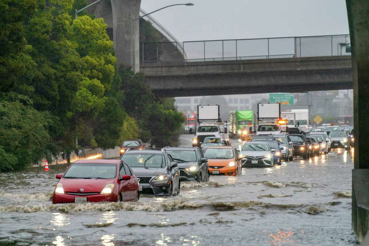
Highway 101 in South San Francisco closed indefinitely in both directions
Southbound and northbound lanes of Highway 101 in South San Francisco were closed indefinitely Saturday morning due to major flooding that caused a traffic jam near the SFO exit, the California Highway Patrol tweeted.
Drivers were urged to either use I-280 as an alternate route or avoid the area as crews work to clear the highway.
Storm causes road flooding, closures across Bay Area
Rain pounding the Bay Area on Saturday morning has wreaked havoc for travelers across the region, forcing closures on roadways and highways due to flooding and mudslides. Officials said drivers should expect delays and take different routes.
In San Mateo County, flooding at Oyster Point on Highway 101 caused the highway to be shut indefinitely in both directions and unleashed massive traffic backups. Caltrans crews were working to clear the drains, said California Highway Patrol spokesman Mark Andrews.
Several roads in the cities of Belmont, Foster City and San Mateo are flooded, according to the San Mateo Consolidated Fire Department. “Be safe and stay home if you can,” fire officials tweeted.
In the East Bay, a mudslide forced the closure of Niles Canyon Road at 8 a.m. and is not expected to reopen until 12 p.m., the Fremont Police Department tweeted.
The California Highway Patrol’s Traffic Incident Information Page summarizes multiple floods and landslides around the Bay Area.
CHP and CalTrans block off multiple lanes as flooding gets as high as three feet along the Southbound 101 in South San Francisco on Saturday.
Adam Pardee/Special to The ChronicleHighway 1 near Big Sur closed due to rock slides at multiple locations
A large stretch of Highway 1 in Monterey County was indefinitely closed Saturday morning due to rock slides reported at multiple locations along the highway, said Caltrans officials. The highway will be closed from Ragged Point in San Luis Obispo County to Big Sur in Monterey County while crews work to clear the debris, officials said. Caltrans officials said they had initially closed the highway on Friday due to a rock slide just south of the Esalen Institute.
Sierra ski lifts closed due to heavy snow and winds
Northstar Ski Resort in Truckee put several lifts on hold Saturday morning, the resort tweeted. Palisades Tahoe said most of its chairs were on hold but some lifts are operating at Alpine Meadows.
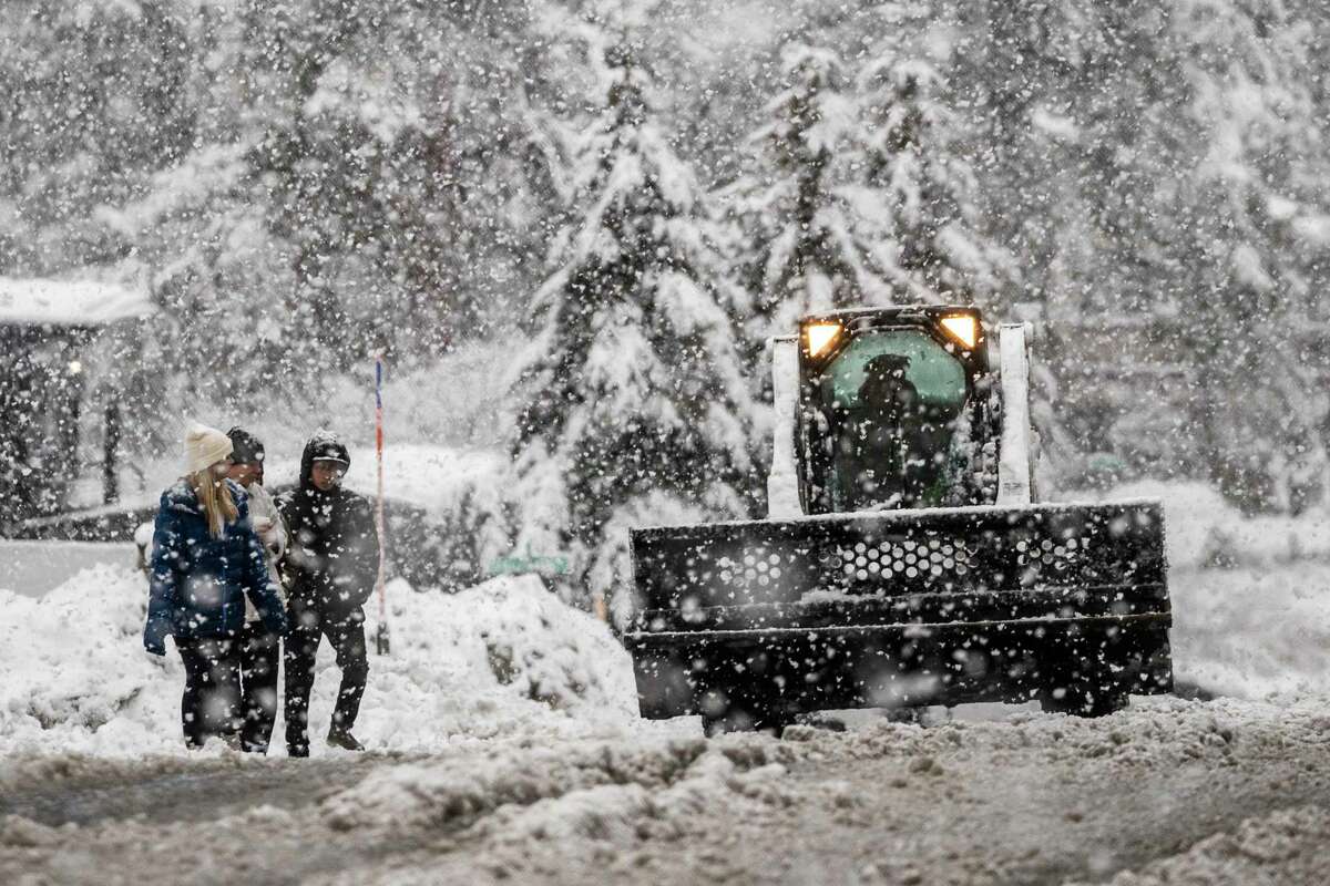
Pedestrians walk along a road as a snow plow works in South Lake Tahoe, Calif. on Saturday.
Stephen Lam/The ChronicleMuir Woods, Alcatraz among the outdoor sites closed
Closures Saturday due to the storm include Muir Woods, Point Bonita Lighthouse, Nike Site, Tennessee Valley Beach, the Golden Gate Bridge overlook at the upper end of Conzelman Road, and the Fort Point Historic Site, according to tweets from the Golden Gate National Recreation Area. Crews “are responding to flooding and downed trees in many Marin County park sites.” The GGNRA also closed Alcatraz Island in the late morning.
Flooding, debris forces closure on highway in Half Moon Bay
Highway 92 is closed between the Lower Lakes area and Main Street in Half Moon Bay due to flooding and debris, according to San Mateo County sheriff’s officials. Motorists were urged to drive safely on roadways and to take alternate routes. It was not immediately known what time the highway will reopen, officials tweeted. Flooding in sections from Skyline Boulevard to Main Street in Half Moon Bay was earlier reported in a tweet from CalFire.
More than 30,000 PG&E customers without power throughout California
Saturday’s storm prompted several power outages across multiple counties in northern California, leaving more than 30,000 customers without power, though power is expected to be restored in many of the larger outages by noon. PG&E officials said Friday that they had been preparing for problems caused by the storm and had extra crews ready to go to the areas most likely to be affected. Check for outages and estimated restoration times here.
Heavy rain floods roadways, car submerged in Belmont
Heavy rain on Saturday morning was causing flooding on several roadways. On Harbor Blvd. in Belmont, a car was submerged in water underneath an underpass at Old County road, police tweeted. While everyone was okay in that incident, police warned that water levels continue to rise. “Please use alternate routes and avoid travel if you can!” officials wrote.
Lake Tahoe remains under winter storm warning
The National Weather Service issued a winter storm warning for the Lake Tahoe area that is set to last through 4 a.m. Sunday. The warning said that heavy snow throughout Saturday would bring an additional 5 to 10 inches to the area, with 1-2 feet for elevations over 7,000 feet and 2 to 3 feet for elevations over 8,000 feet. On top of that, the warning said, wind gusts will be up to 100 miles per hour across the Sierra ridgelines and 35 mph in lower elevations. “Travel could be very difficult to impossible,” the warning said. “Strong winds could cause tree damage and lead to power outages.”
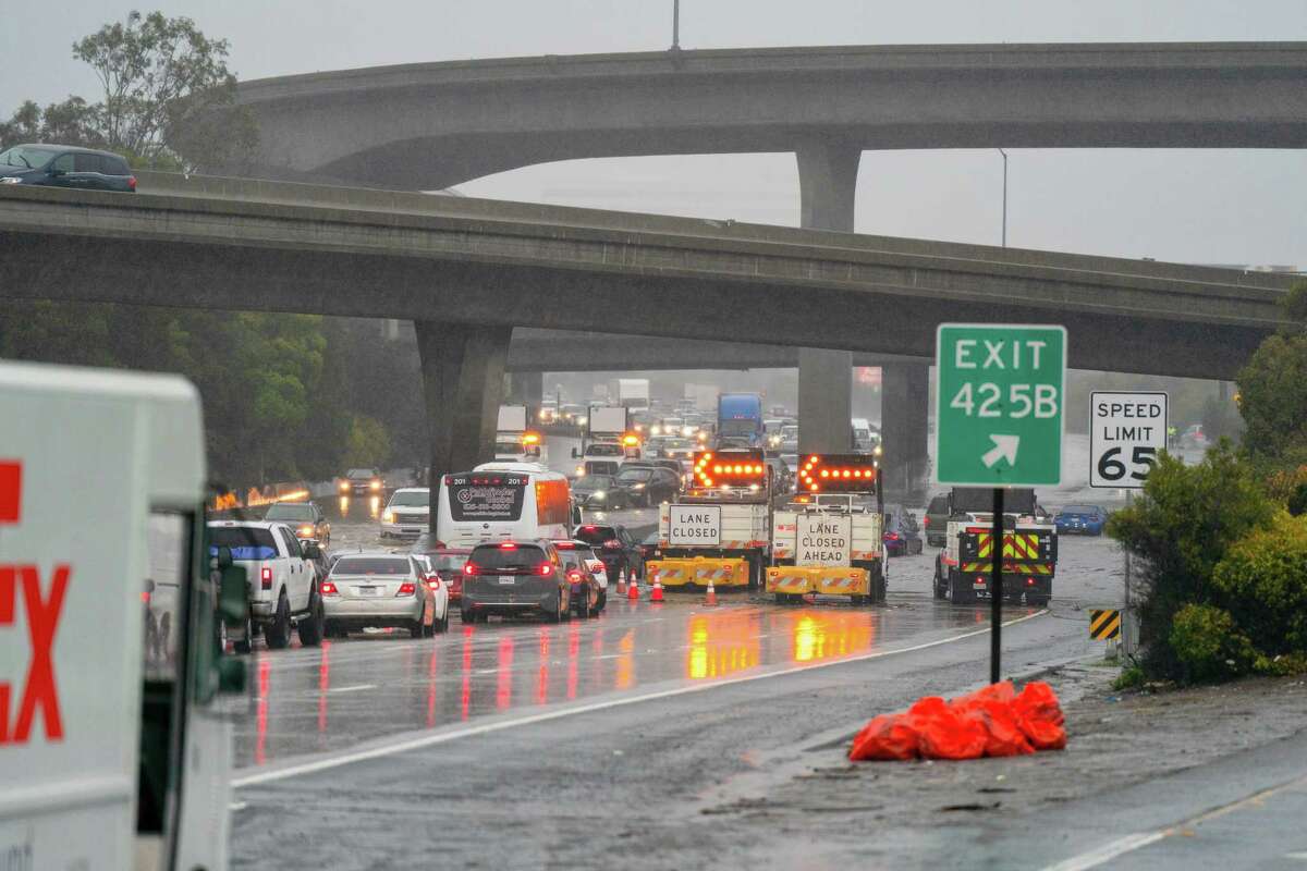
Multiple accidents along Highway 280
The North County Fire Authority, which serves Brisbane, Daly City and Pacifica, tweeted that there had been multiple vehicle accidents along 280 on Saturday morning. Around 6 a.m., all southbound lanes were closed where 280 meets Highway 380 for about a half hour before a tow truck arrived to clear it up, it said. The fire authority asked that people adjust their speed accordingly with the weather conditions.
Wind advisories in effect
Wind advisories were in effect across the Bay Area Saturday morning. The highest wind gusts recorded so far were 63 miles per hour atop Loma Prieta in Santa Clara County, the National Weather service said. Gusts ranging from 44 mph to 62 mph were reported across the Bay Area.
Latest rain totals across Bay Area
The National Weather Service released its 24-hour rain totals for Friday, the first day of the winter storm, and Mt. Tamalpais was the clear standout, having already hit 4.8 inches of rain. The Santa Cruz mountains came close at 3.67 inches, while the more mountainous parts of the East and North Bay areas hovered around 2.5 inches of rain. Most of the more populous parts of the Bay Area remained under or around 1 inch of rain as of 2 a.m. on Saturday, but the heaviest rain had only just started, according to the weather service — the bulk of it is expected this morning.
Longer term forecast shows more rain due next week
The atmospheric river that’s been responsible for this week’s back-to-back winter storms will slowly fizzle out by Sunday, leaving behind a soaked Golden State. But after a brief break from the rain, more wet weather is in store. The European and American weather models signal a strong west-to-east jet stream across the Pacific Ocean with winds that will funnel rounds of moisture from the tropics toward North America. Some of the moisture will break off from the flow and the plumes of moisture will narrow, evolving into atmospheric rivers that will eventually reach the West Coast. This past week’s atmospheric river helped fuel two winter storms. In the coming week, weather models are anticipating a repeat, but with two atmospheric rivers.
Read more about the forecast for the first week of January from meteorologist Gerry Díaz.
When will the rain peak?
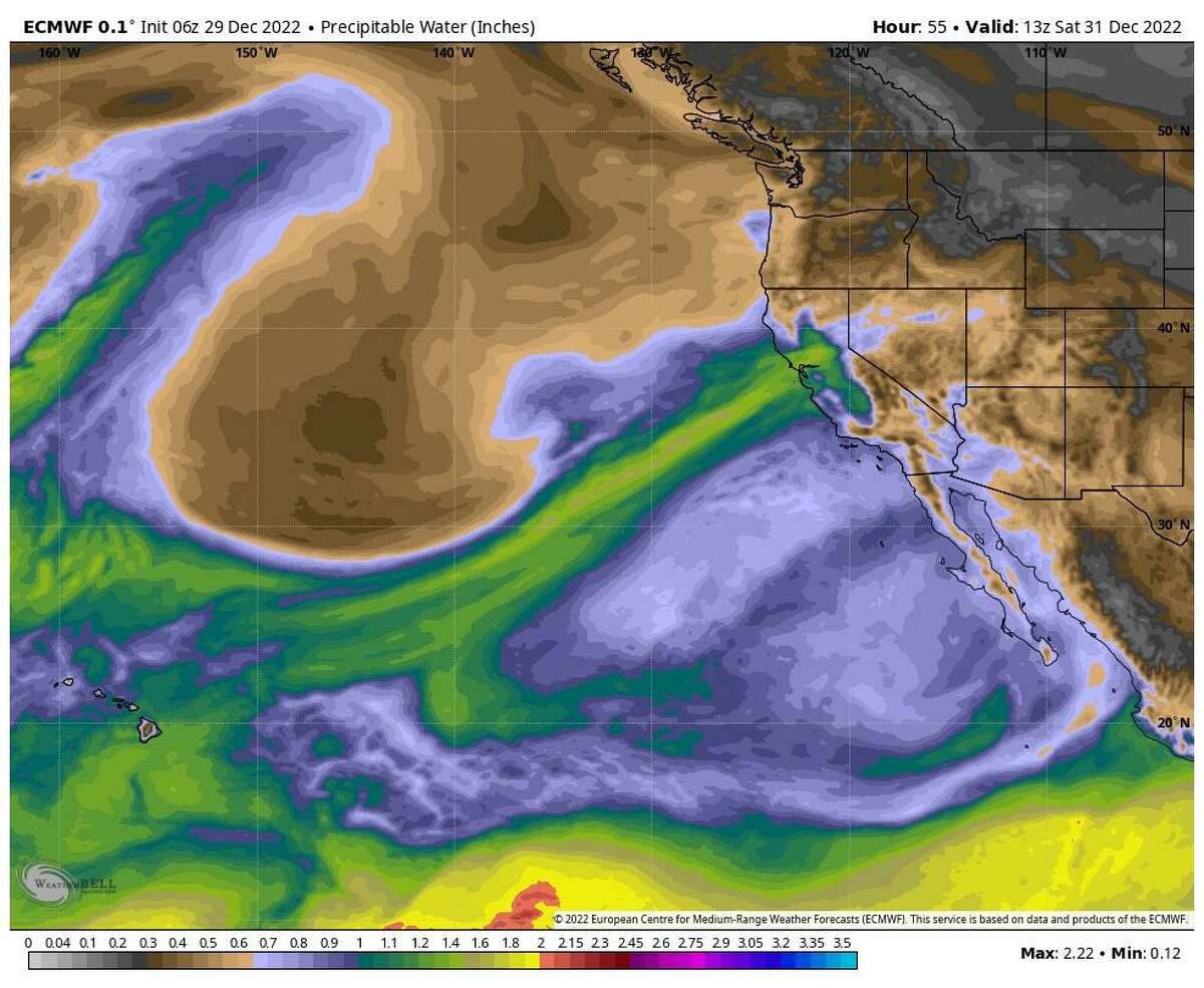
This weekend’s storm door is wide open in California, with a rush of moisture from the tropics -often called the pineapple express — expected to take aim at the Bay Area and most of Southern California over the course of New Year’s Eve.
Gerry Díaz / WeatherbellThis week, rain around the Bay Area dropped “1 to 4 inches,” which has saturated the soil, according to NWS meteorologist Brooke Bingaman. “The highest kind of concern for tomorrow is between 4 a.m. and 10 a.m. (Saturday), that is when the more organized cold fronts going to move through,” she said. “The good news is that it will move through quickly. The bad news is it is going to pack a little bit of a punch.”
That punch, Bingaman said, will be the winds associated with Saturday morning’s cold front expected to hit 20 to 30 mph with gusts between 40 and 50 mph.
Chronicle newsroom meteorologist Gerry Díaz wrote in his forecast for the weekend that the stage is set for “excessive rainfall on the coast and bays,” and “heavy snowfall in the Sierra Nevada and Southern California mountains,” as well as “a statewide storm system that will wreak havoc on travel plans for New Year’s Eve.”
This map shows where it rained the most this week
Winter storms fueled by an atmospheric river have drenched California this week, adding up to significant rainfall in some areas. From 4 a.m. on Dec. 23 to the same time on Dec. 30, most of San Francisco saw about 3 inches of rain, while about 8 inches fell in Sonoma County, north of the Russian River. Even more rain fell farther north in the state. To see where in California felt the brunt of the storms and find out how much rain fell in your area, see our detailed map.
Entire Bay Area under flood watch ahead of the weekend
A flood watch will be in effect for the Bay Area from Friday evening to Saturday evening as more rain arrives in the region, according to the National Weather Service. Moderate to heavy rain is expected during that time frame, and it could be more than already saturated soils can absorb. Rapid rises of rivers, streams and creeks are expected, the National Weather Service said, and urban areas and roadways with poor drainage may see flooding. Read more about prospects for flood conditions in low-lying areas.
Will crab season begin today?
The winter storms added uncertainty to the launch of the commercial Dungeness crab season, which was due to open early Saturday morning after multiple delays. Many fishers told the Chronicle that they didn’t know if it would be possible to deliver crab in time for New Year’s Eve celebrations due to the poor weather.
Even if the fishers succeed today, many seafood buyers will be closed for the New Year’s holiday. The soonest most people can expect to see local Dungeness crab in stores is early next week, though some bigger boats that can handle the weather and smaller ones that sell directly off of the boat could make it out in time for a New Year’s Eve harvest. Read more about the launch of crab season.