A “flash freeze” could accompany this storm as temperatures drop as quickly as one degree per hour, rapidly freezing any rain or melted snow remaining on the ground.
A “flash freeze” occurs when rapidly falling temperatures “quickly turn any wet or slushy roads to ice,” the Des Moines National Weather Service noted, warning it will likely create significant travel problems across the Hawkeye State on Thursday.
The arctic chill won’t spare the rest of the country either. By Monday morning 235 million Americans, or roughly 86% of the country will experience temperatures below freezing. This includes every state in the Lower 48.
Blizzard sets the stage for extreme cold
Strong winds, blowing snow and rapidly falling temperatures are expected through Friday from Nebraska to Michigan.
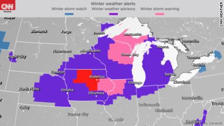
Blizzard warnings are in place across Central and Northern Iowa through Friday morning while winter storm warnings and advisories stretch further east to Chicago and Grand Rapids.
The criteria for blizzard conditions does not necessarily require snow to be falling from the sky.
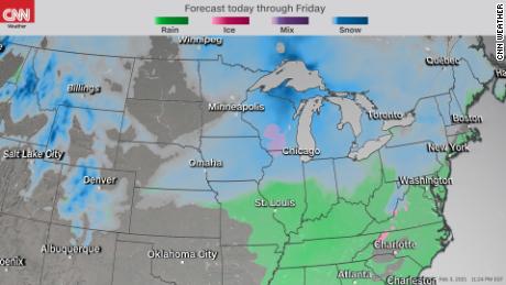
As with this storm, only moderate accumulations are forecast, ranging from 2-5 inches in Des Moines and up to 8 inches in Green Bay. Higher totals can be expected downwind from Lake Michigan in favored Lake Effect areas, where up to a foot of snow is possible.
Ahead of the system, a wintry mix of rain and snow is forecast as temperatures briefly surge before dramatically falling behind the cold front.
Winds are forecast to gust over 45 miles per hour, blowing snow and reducing visibilities under a quarter mile across parts of Iowa. As the mercury drops and the snow begins to drift over roadways, conditions will deteriorate at a moment’s notice.
Waterloo, Mason City and Fort Dodge are all predicted to experience “extreme” travel impacts from this potent storm, according to the NWS hazards matrix.
Even though blizzard warnings are in place, high snow totals won’t be the biggest threat from this storm. The real show stopper will be the cold air settling in early next week.
A flash freeze to hit the Midwest
The coldest air will start diving south through the upper Midwest and Great Lakes on Saturday. Places in Central Wisconsin could see temperatures plummet to -25F on Sunday morning, with high temperatures struggling to make it to zero. Overnight lows could be cold enough for your car’s antifreeze to solidify.
“We get two to three of these cold snaps every year,” said National Weather Service Office Meteorologist Marcia Cronce. “We are heading into the coldest air of the season, it will feel jolting.”
St. Paul school districts cancels classes if the 6 a.m. forecast for the following day is -25F or windchills are forecast to drop to -35F.
The polar vortex is coming
This will cause the polar vortex to weaken even further, making for bitterly cold conditions.
The cold trend will continue for the next 10 days.