The modern tornado record goes back to 1950. Until Saturday, a tornado had never been recorded in Connecticut during the months of November or December.
Saturday’s severe weather event featured a powerful line of thunderstorms that produced small hail and strong winds. This line also produced at least three brief tornadoes in Connecticut and several more on Long Island.
Advances in radar technology allow us to not only see the wind speed and direction in a storm (which is useful for picking out areas of rotation) but also whether the radar is picking up rain drops or other targets.
In Saturday’s case, there were three instances of lofted tornado debris in Connecticut known as a Tornado Debris Signature or TDS, which we were able to detect in real time.
The first TDS occurred in Cheshire at 3:31 p.m. just west of downtown. There is a fairly widespread area of damage in this part of town.
This 4 panel radar plot shows precipitation intensity (upper level), radial wind velocity (upper right), spectrum width (lower right), and correlation coefficient (lower left) at 3:31 p.m.. Winds over 60 mph were sampled by the radar along with a robust circulation, but at this time no tornado debris is being detected.
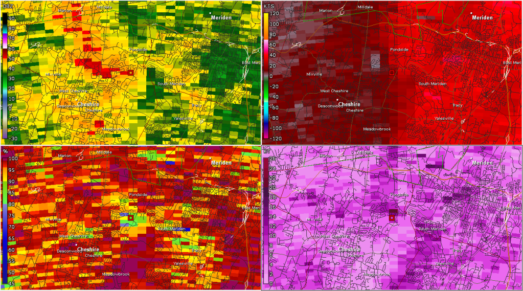
Six minutes later, the rotation has weakened, but the plot in the lower left shows a lowering of correlation coefficient which indicates lofted tornado debris (likely many leaves).
Some residents are cleaning up after trees fell down in and on their properties, as well as on local streets.
At 3:45 p.m., the southern portion of the line that had been exhibiting rotation over Long Island Sound moved inland over Branford and likely resulted in a tornado touch down in the Pine Orchard section of town. Lofted tornado debris was detected into portions of Guilford with sporadic damage reports as far northeast at Cornwall Rd in the Guilford Lakes section of town.
The clean up is continuing on Sunday after strong storms moved through Saturday and caused damage across the state.
A third tornado appears to have touched down in northeastern Connecticut. It started in Griswold and continued into Plainfield, Sterling, and Rhode Island. The Tornado Debris Signature was quite clear from the weather radar in Boston and there are several reports of damage.
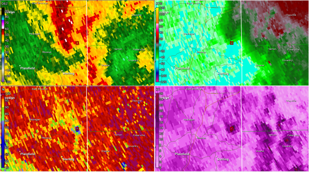
4:55 p.m. radar grab showing the strong rotation in the upper right and lofted tornado debris in the lower left over Sterling.
Saturday’s tornado event was well forecast. On Friday, we mentioned severe weather was possible and by Saturday morning, our forecast was more certain and included the risk for tornadoes given the strong low level wind shear and an adequate amount of instability.
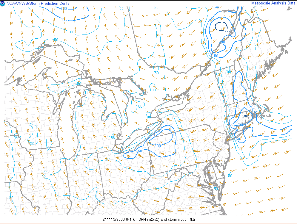
SPC Mesoanalysis shows very strong low level wind shear over CT which is favorable for rotating storms.
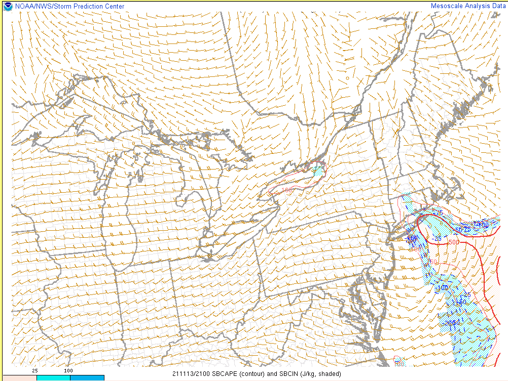
SPC mesoanalysis shows a small, but adequate, amount of instability. Instability is a requisite for thunderstorms to form.
While radar confirmed three tornado touchdowns Saturday in Connecticut, the National Weather Service will make the final determination about the intensity and path of each storm.
This was certainly a November severe weather event to remember. Thankfully, there are no reports of injuries and few reports of structural damage.