A potent winter storm that turned deadly in California is now threatening powerful tornadoes in the South and heavy snow, sleet and freezing rain in the Midwest.
More than 3 million people are under a tornado watch until 9 p.m. CT in parts of Arkansas, Texas, Louisiana and Oklahoma. Another tornado watch has also been issued for eastern Oklahoma, southeast Kansas and northwest Arkansas, according to the National Weather Service’s Storm Prediction Center.
And tornadoes are not the only risk in the region. Large hail – potentially up to 2 inches in diameter – and thrashing winds of up to 70 mph are possible “well into the night across much of the area,” the Storm Prediction Center warned.
Anyone in areas at risk of tornadoes should seek safe shelter immediately, said Brad Bryant, meteorologist-in-charge at the National Weather Service office in Shreveport, Louisiana.
“If you wait around for a warning to be issued, it is too late,” Bryant said Monday. “You need to have a safe shelter plan in place in advance of these storms.”
He encouraged anyone needing help – especially those living in mobile homes – to contact local emergency mangers or law enforcement for sheltering options.
“Since mid-November we’ve had three rounds of severe weather and we have had fatalities, most of which have occurred in mobile homes,” Bryant said.
In response to the severe weather and flash flooding expected in parts of Texas, Gov. Greg Abbott activated state emergency response resources Monday.
“The State of Texas is proactively working to ensure Texans and their property remain safe from severe weather threats that could impact eastern regions of our state today and early tomorrow,” Abbott said in a statement. “As we monitor conditions and potential threats, I urge Texans in affected areas to heed the guidance of local officials and remain weather-aware as severe weather systems develop. We will swiftly provide all necessary resources to address severe weather and protect our communities.”
From Missouri down to the Gulf Coast, more than 30 million people are at risk for severe weather Monday, CNN Meteorologist Dave Hennen said.
And more tornadoes and damaging winds are possible Tuesday in parts of Louisiana, Mississippi and Alabama as the storm moves east.
Farther north, more than 15 million people from Utah to Wisconsin are under winter weather alerts Monday.
The same storm system caused record-setting rainfall and deadly flooding in drought-stricken California over the weekend. And another wave of intense rainfall this week could exacerbate dangerous flooding.
In the Plains and Midwest, rapid snowfall of 1 to 2 inches per hour is forecast from the Nebraska panhandle through southwest Minnesota – leaving a total of more than 12 inches of snow by late Tuesday. The onslaught of snow could be accompanied by thunder.
“These intense rates combined with gusty winds will produce areas of blowing and drifting snow, resulting in snow-covered roads, reduced visibility and difficult travel,” the Weather Prediction Center said.
Significant ice accumulation could lead to power outages and treacherous travel conditions.
Freezing rain could cause more than a quarter-inch of ice to stack up from northeastern Nebraska to northwestern Iowa to southern Minnesota late Monday into Tuesday.
“Travel will become hazardous, if not impossible, later this evening (into) Tuesday in many areas,” the National Weather Service in Sioux Falls said Monday.
Northern California communities submerged in mammoth flooding over the weekend could get deluged by even more rainfall later this week.
It’s not clear how much this storm will make a dent in drought conditions that have gripped California, which started 2022 with the driest beginning of the year on record and ended with flooded roads and swelling rivers.
“Early precipitation forecasts for the midweek storm looks to be around 2 to 3 inches possible in the Central Valley with 3 to 6 inches or more of liquid precipitation in the foothills and mountains,” the weather service office in Sacramento said.
An atmospheric river – a long, narrow region in the atmosphere which can carry moisture thousands of miles – fueled a parade of storms over the weekend, which led to record-setting rainfall and water rescues.
At least two people died, including one found inside a submerged vehicle in Sacramento County and a 72-year-old man struck by a falling tree at a Santa Cruz park, officials said.
Now, another atmospheric river could bring heavy rain and more flooding Wednesday to Northern and central California, including the Bay Area.
This next storm “looks like it will cause dangerous situations,” the National Weather Service in San Francisco said.
Officials urged residents to avoid driving in standing water.
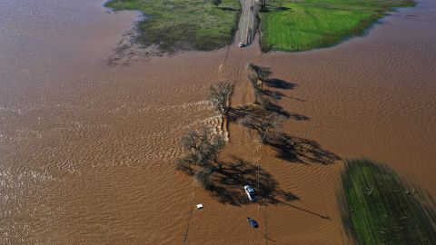
Flooding from the Cosumnes River forced the closure of Highway 99 south of Elk Grove in Sacramento County, the California Department of Transportation tweeted Sunday. “SR 99 is one of the state’s heavily traveled, and commercially important, corridors,” its website said.
Over the past few days, “dozens upon dozens” of people had been rescued, Cosumnes Fire Department Capt. Chris Schamber told CNN affiliate KCRA. Aerial footage from the station showed cars submerged in floodwater up to their door handles.