By Terry Eliasen, Meteorologist, WBZ-TV Exec. Weather Producer
BOSTON — It’s the most wonderful time of the year!!
But getting there this year. . . not so magical.
I am guessing you may have one more gift to buy or perhaps still need to make a run to the grocery store? Or maybe you are one of those lucky folks who are hopping in a plane, train or automobile in the next 24 hours? Welp. . . all I can say is, good luck, take it slow and stay calm!
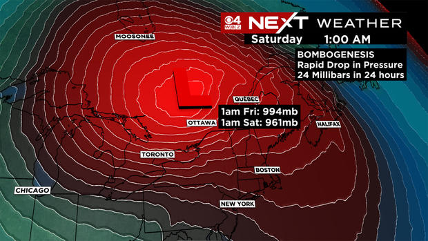
There is a massive storm forming as we speak. Perhaps you have heard some call it a “bomb cyclone.” While the term seems like a load of hype, something meant to make headlines, it is rooted in truth. Bombogenesis occurs when an area of low pressure drops at least 24 millibars in 24 hours. This is something that typically happens during a powerful nor’easter once or twice a year.
Read more: What is a bomb cyclone?
This time, it is occurring to our west, with a storm heading up into Canada. And, while folks in the upper Midwest are getting all the blinding snow, we here in New England are on the “warm side” this time. Sounds like a nice place to be, but, as you will soon find out, we will have our own wild weather to deal with.
CBS Boston
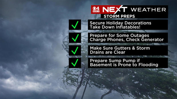
First and foremost, let’s make sure we are all prepared for what’s NEXT!
If you have any inflatables or loose holiday items in your yard, you will need to secure them or bring them in immediately! Your 20-foot Santa will be somebody else’s lawn decoration otherwise.
While we don’t expect widespread power outages, it is still a good idea to make sure your phones are charged and the generator is ready to go.
And, if your home or yard is prone to flooding, check the gutters, storm drains and sump pump just in case – we are expecting 1-3″ of water.
CBS Boston
TIMELINE:
7 p.m. Thursday
The rain arrives, light to moderate, shouldn’t have too big of an impact on travel just yet. Winds start to pick up, gusting over 20 mph out of the east. Some wet snow is possible above 1,000 feet in central and western Mass., but it won’t last long.
CBS Boston
Overnight:
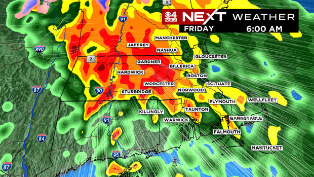
The rain becomes heavy around and after midnight. Between midnight and dawn, we get waves of torrential downpours and the winds steadily increase out of the south-southeast.
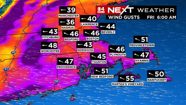
6 a.m. Friday
CBS Boston
A torrential, windswept soaking rain. Southeast wind gusts 40-60 mph and rainfall coming in sideways. Lots of giant puddles and hydroplaning hazards on the roadways.
CBS Boston
11 a.m. Friday
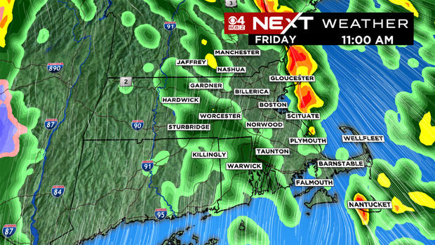
The rain becomes more scattered in nature with smaller lines of downpours here and there. We get a brief “break” from the strongest winds, although we will still have frequent gusts between 30-50 mph. At this point the worst is over, most of the rain has fallen, but we still have several more hours of scattered, gusty showers.
CBS Boston
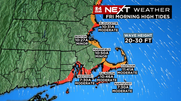
This is also when the coastal flood threat is highest, between 9 a.m. to 1 p.m. with the high tide rolling in. We will see minor coastal flooding in the southeast and southerly facing beaches with some pockets of moderate flooding and inundation.
CBS Boston
5:30 p.m. Friday
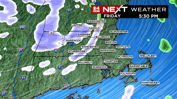
The rain tapers off by late afternoon and the cold, Arctic air starts to rush in. There may be a few snow showers or squalls with this wind shift and sudden temperature drop.
CBS Boston
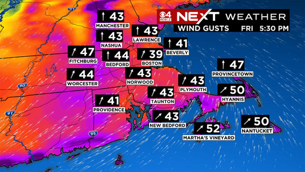
The winds will shift to the west-southwest and actually pick up again, gusting 40-60 mph. For some inland folks, this will be the timeframe with the strongest winds of the day.
CBS Boston
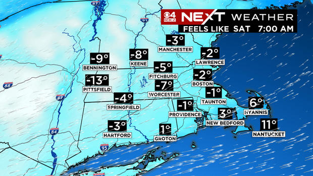
Friday night will be all about the cold. The harshest air of the season thus far will rush in behind the storm. . . the wind gusts will drop overnight to between 15-35 mph, but that will be enough to make it feel like it is below zero by Saturday morning.
We are not all that concerned about a flash freeze given how strong the wind will be. The winds will work to dry things out very quickly, so most roads should be mainly dry as the colder air pours in. Just beware that there could be some leftover water in your driveway or deck that could ice up Friday evening.
CBS Boston
So, it won’t be a white Christmas for most of us this year…BUT, there is one spot that still has a shot. Believe it or not it is Cape Cod and the Islands! Late Friday night and during the day Saturday, there will be some ocean-effect snow showers that will be close to or over this area. It is possible that a light accumulation could happen down there. . . just hours before Christmas morning!
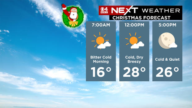
The Patriots game on Saturday afternoon will be frigid. Temperatures will be stuck in the 20s and wind gusts 20-30 mph will make it feel like the single digits!
And, finally, Christmas Day will be quiet and cold. . . less wind than Saturday but still enough of a breeze to leave a bite in the air.
CBS Boston
The WBZ Weather Team will keep you updated throughout the storm and the holiday weekend. Please stay tuned and stay safe! Happy Holidays!
