Heavy rain in eastern Kentucky leads to life-threatening flash flooding

Flash flood emergencies were declared early Thursday for areas including Perry, Leslie and Clay counties, and flash flood warnings are in effect for other nearby areas, the National Weather Service said.
“This is a particularly dangerous situation. Seek higher ground now!” the weather service said in one alert early Thursday.

In the small creekside town of Hindman, waist-high water turned a main road into a river before dawn, video from stormchaser Brandon Clement shows.

Barbara Wicker was worried about relatives in town, including five grandchildren, because water had surrounded their homes, she told Clement.

“I can’t reach them. I can’t reach 911. … There’s no help in sight,” Wicker told Clement early hursday outside in Hindman, a Knott County town roughly a 130-mile drive southeast of Lexington.

“That goes way up in there — everybody’s stuck,” Hindman resident Kendra Bentley, also standing near a road outside, told Clement about floodwater surrounding homes.

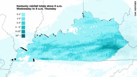
Rain ramped up in the region Wednesday night after falling for the past few days.

In Perry County alone, 8 inches of rain had fallen in the past 24 hours as of 8 a.m. Another 1 to 3 inches are possible in the area during the day, the weather service said.

And more flooding is possible Thursday especially in parts of eastern Kentucky, southern West Virginia and far southwest Virginia, the weather service said.

Residents describe having to flee their homes barefoot after record-breaking flooding in St. Louis. And there's more rain on the way

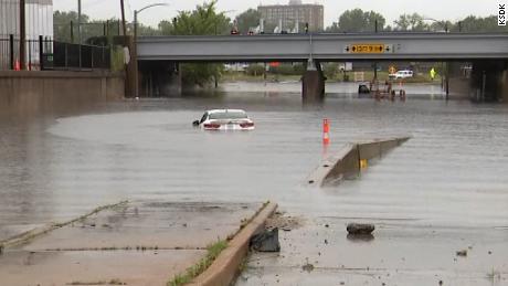
Swift-water rescues have been reported Thursday in Kentucky’s Perry County, including in Chavies, a community of a few hundred people roughly 30 miles west of Hindman and a 110-mile drive southeast of Lexington, the weather service said.

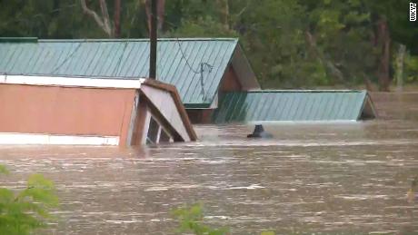
In the Breathitt County community of Jackson, floodwater swiftly ran past a home in Thursday’s pre-dawn darkness, carrying a trash can and other debris with it, video recorded by Deric Lostutter showed.

Breathitt County opened its courthouse building as a shelter for those displaced by the flooding, the county’s emergency management agency said on Facebook.

“Many roadways in the county are becoming covered with water and are impassable. Please stay off the roads if at all possible tonight,” the post said.

Rescue crews have been unable to reach several areas due to “swift water over roadways,” the emergency management agency noted.
Water nearly swallows some buildings Thursday morning in the community of Lost Creek in eastern Kentucky's Breathitt County.

‘Seemingly never-ending fire hose’ of moisture across much of US

Thursday’s inundation in Kentucky comes two days after record-breaking rainfall caused widespread flash flooding in the St. Louis area.
It’s part of a “seemingly never-ending fire hose of monsoonal and Gulf of Mexico moisture that is producing a conveyor belt of heavy rain and thunderstorms from the Southwest to the central Appalachians,” the Weather Prediction Center said Thursday morning.

Recent rain, with more coming, makes additional flash flooding likely in parts of the Ohio and Tennessee valleys and central Appalachians over the next two days, the prediction center said.

A moderate risk — or level 3 of 4 — of excessive rainfall exists Thursday for parts of Kentucky, West Virginia and northern Tennessee — as well as parts of northern New Mexico and southern Colorado, the prediction center said.
The climate crisis is supercharging rainfall around the world. The atmosphere can hold more moisture as temperatures climb, and that can lead to higher rainfall rates and make record-breaking downpours more likely.
Scientists are increasingly confident in the role that the climate crisis plays in extreme weather, and have warned that these events will become more intense and more dangerous with every fraction of a degree of warming.

Read original article here

Leave a Comment