“Port users should secure boats and vessels in the harbor and on Belmont Point. Please check your lines and gear periodically to avoid losses,” the town of Nome said on its Facebook page.
The town said its recreation center will serve as the emergency shelter.
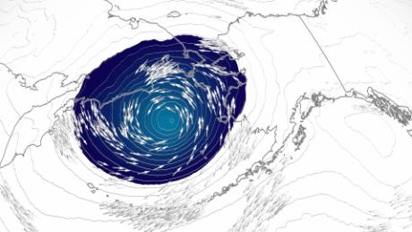
The system was moving over the Bering Sea, which spans the northern Pacific Ocean between Alaska and Russia.
“This is a dangerous storm that is expected to produce widespread coastal flooding south of the Bering Strait with water levels approaching levels not seen in nearly 50 years,” the weather service warned Thursday.
Along Alaska’s shore, the main threats are a double-whammy of coastal flooding and winds up to 60 mph with higher gusts that could displace loose objects, damage buildings and bring down powerlines.
Weather officials in Alaska also urged residents to prepare for the storm as it could threaten to overwhelm critical infrastructure and wash away roads. The storm’s impacts are expected Friday through Sunday morning, with water levels rising the highest Saturday.
Coastal flood watches have also been issued for all coastlines along the west coast of Alaska between just north of the Arctic Circle down through the Kuskokwim Delta coast.
The last time Alaska saw a storm this strong was in 2011, when it left behind a wide swath of destruction. Like Merbok, the 2011 system was an extratropical storm. An extratropical storm or cyclone has cold air at its core — unlike a tropical storm or cyclone which has a warm core. Both can cause significant damage from strong winds, heavy rain and storm surge.
“When a big storm comes in, we always say, ‘Does it compare to the 2011 storm?'” Jonathan Chriest, a meteorologist with the weather service in Fairbanks, told CNN. “This is the first storm since 2011 that we have high confidence … will compare impact-wise.”
“Winds will peak early Saturday morning near Shishmaref, and during the day Saturday near Kotzebue and the Chukchi Coast,” the weather service said. “Coastal flooding will occur, in addition to significant beach erosion.”
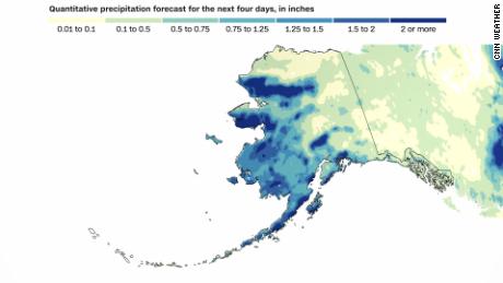
While most areas will see around 1 inch of rain with this storm, some could pick up as much as 3 inches through the weekend.
Even if Anchorage — more than 500 miles from Nome — picks up 1 to 2 inches from this storm, it will push this year into the top five wettest years on record.
CNN’s Allison Chinchar and Pedram Javaheri contributed to this report.