Severe weather is expected to develop late Friday from the lower Mississippi Valley to central Ohio ahead of a strong cold front, with the greatest threat for nighttime tornadoes stretching from Arkansas to Indiana.
Over 50 million people are at risk for severe storms Friday.
“This dynamic, sprawling storm will impact more than half the country. It’s a classic clash of air masses,” said CNN meteorologist Gene Norman.
As cold, arctic air surges south it will clash with record warm and humid air in place across the South, sparking severe storms where the air masses meet.
The last time there was a moderate — level 4 — risk of severe storms issued in December was December 16, 2019.
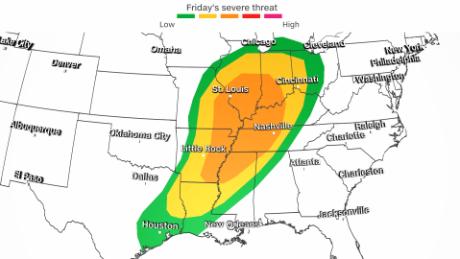
Meanwhile, a slight risk — level 2 — of severe storms encompasses the enhanced risk area and extends from eastern Texas to northern Indiana. There is also a marginal risk — level 1 — of severe storms that stretches from Houston to Chicago.
Severe storms developing after dark pose a significant threat for nighttime tornadoes to occur, some of which may be strong, according to prediction center.
“Nighttime tornadoes are statistically twice as deadly as day time storms,” CNN meteorologist Dave Hennen said.
This is why it is important to have an alert system such as a weather radio or an app on your phone that can wake you up if a tornado watch or warning is issued for your area.
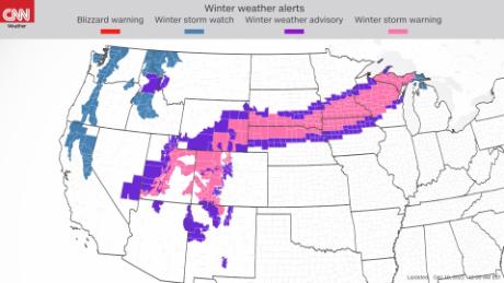
Winter returns for a large section of the US
On the northern part of this system, snow will blanket a large area of the country from the Intermountain West to the Upper Great Lakes through Saturday. Over 10 million Americans are under some form of winter weather alerts from this system.
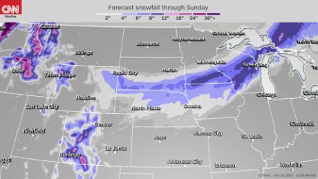
Many motorists will be forced to test their winter driving skills for the first time this season as conditions quickly deteriorate under a band of heavy snow from Cheyenne, Wyoming, to Marquette, Michigan.
Snowfall rates of 1 to 2 inches per hour are possible tonight into Saturday morning across a large stretch of the Upper Midwest and Great Lakes region.
A widespread area of 6 inches of snow is anticipated, with up to a foot possible where the center of the low-pressure system pivots and dumps the heaviest snowfall. This area includes southern Minnesota, northern Wisconsin and portions of Michigan’s Upper Peninsula.
Heavy snow will be accompanied by strong gusty winds that will make travel conditions extremely difficult.
Blowing snow from winds gusting over 50 mph will reduce visibilities and create slick roads from the Central Plains to the Upper Great Lakes. Potential travel impacts could be greatest across the heavily traversed Interstate 90 corridor.
High winds expected behind system
As the storm pushes east late Friday, it will intensify, allowing for howling winds to develop.
A High Wind Watch is in effect from Saturday morning through Saturday evening for much of southern Michigan, including Detroit, where southwest winds of 20 to 30 mph with gusts into up to 60 mph are possible.
This could lead to downed trees and power lines. “Widespread power outages are possible,” the weather service warns.
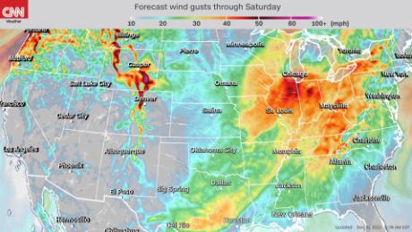
Those high winds will also impact areas in and around Lake Michigan, including Chicago, as a gale watch remains in effect from late Friday night through Saturday afternoon.
As the storm moves across the area, northwest winds of 25 to 35 knots are expected with gusts up to 45 knots along with 6- to 13-foot waves.