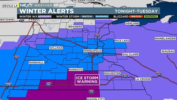
MINNEAPOLIS — After a quiet start to the New Year, we jump into our third big storm of the past four weeks — with this one spanning more than two days.
The National Weather Service has issued an ice storm warning in several south-central Minnesota counties. Much of Minnesota, including the Twin Cities, is under a winter storm warning.
RELATED: Minnesota School Closings & Delays
Light snow started to fall in the southern metro and down south Monday night, and it will continue overnight, but it won’t advance much farther north until the middle of Tuesday morning.
CBS
Tuesday will be a warmer day, with a high of 32 degrees in the metro. But this will be problematic because it will toy with the phases of precipitation, and create some wet, heavy snow.
The heaviest snowfall will occur Tuesday mid-morning through mid-afternoon. We could see rates of 1 to 2 inches per hour before a lull in the action in the evening. Wind speeds will also be between 10-15 mph, which will cause some blowing snow.
Lighter bands take over Tuesday evening, and it will keep on lightly snowing in the metro through early Thursday, with the day’s high temp dropping into the mid-20s
The metro is expected to get between 6-10 inches of accumulation by Thursday, while areas north and west of the metro could see even more. Parts of southwestern Minnesota could get more than a foot of snow.
Friday’s high temp will only be in the high teens in the metro, but we’ll begin a slow warmup through the weekend, with highs in the upper 20s to start out the work week.
