ORLANDO, Fla. — Ian’s winds strengthened to 75 mph Thursday afternoon, meaning the storm is once again a hurricane.
This is a breaking news update. A previous version of this report is below.
Hurricane Ian made landfall in Florida on Wednesday as a strong Category 4 hurricane, bringing with it the threat of high winds, dangerous storm surges and even tornadoes.
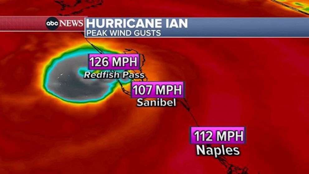
After traveling north through the Gulf of Mexico, Hurricane Ian made landfall along the southwestern coast of Florida around 3:05 p.m. ET as a Category 4 storm, with sustained winds near 150 mph, the National Hurricane Center said.
Landfall was near Cayo Costa, an island off the coast of Fort Myers. The storm was approaching Category 5 strength as it headed toward the coast.
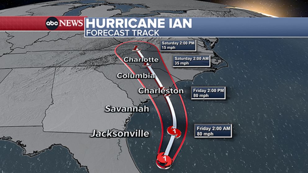
Projected path and spaghetti model
The storm has since been downgraded to a tropical storm, with winds of 70 mph midday Thursday. It’s near Florida’s east coast and is moving back over water near Kennedy Space Center.
Ian is expected to re-intensify over the Atlantic and become at least a Category 1 hurricane as it approaches the South Carolina coast near Charleston Friday morning. Landfall is expected around noon.
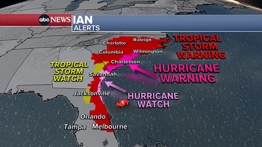
Weather alerts now extend across four states, from Florida to North Carolina. A hurricane warning has been issued for the entire coast of South Carolina and a tropical storm warning has been issued for North Carolina.
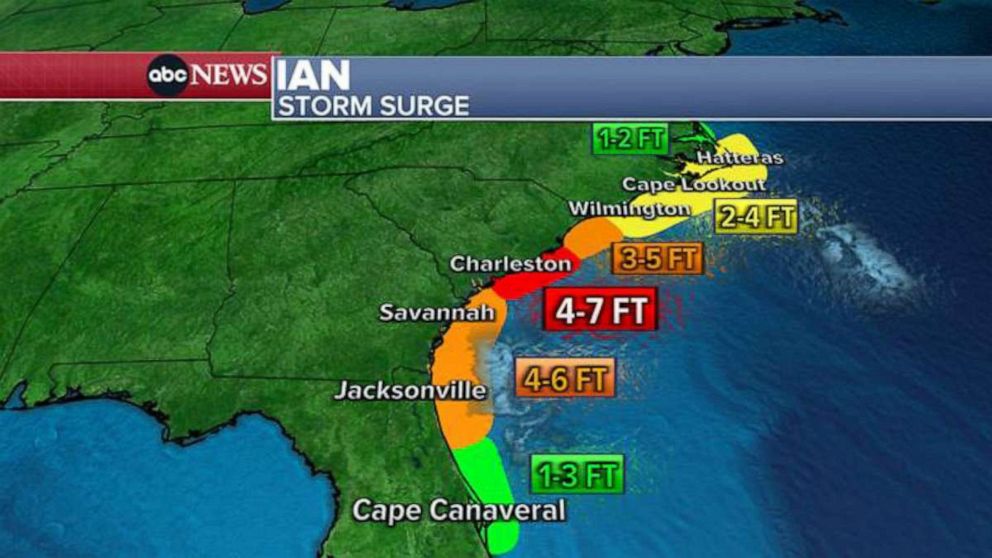
Storm surges
Parts of Florida have reported record storm surge, and life-threatening storm surge remains a risk as Ian moves north. Charleston, South Carolina, could see storm surge at least 7 feet high.
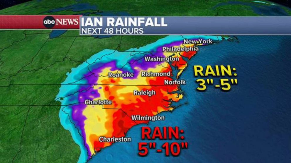
Rainfall
A large swath of the Florida Peninsula and up along the coast to South Carolina is forecast to get more than half a foot of rain through the upcoming weekend. Up to 10 inches is forecast from Charleston to the North Carolina border.
Up to 6 inches is also possible in parts of North Carolina and southern New Jersey.
Some of the heavy rain will come up to Philadelphia and New York City area by Saturday morning, with 2 to 3 inches of rain possible locally.
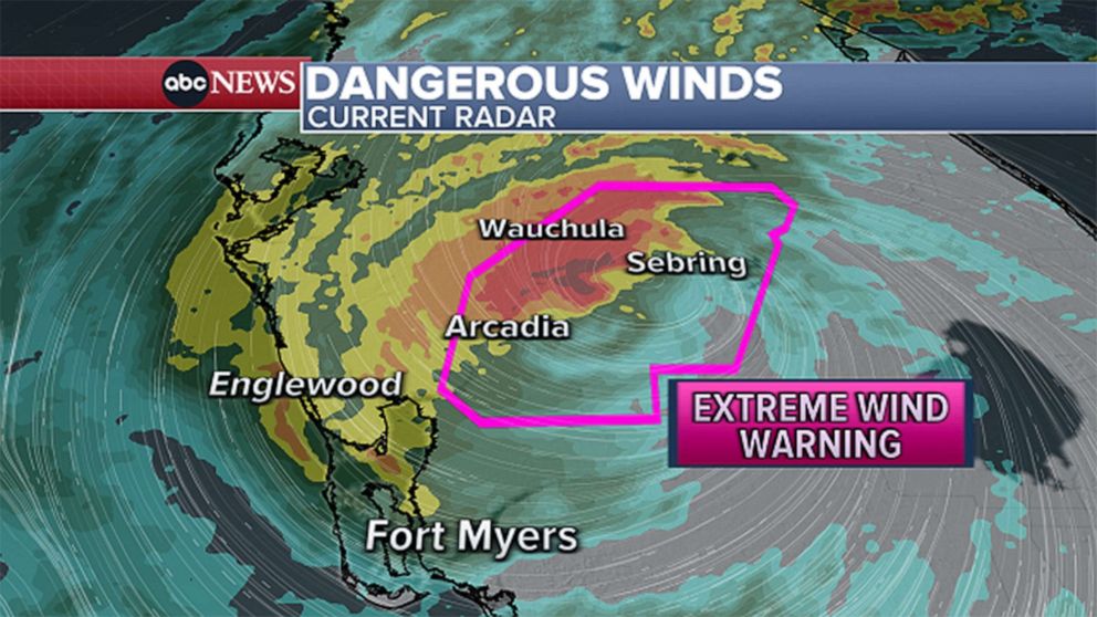
Extreme wind
Sustained winds could exceed 115 mph in some parts. As Ian moves north, tropical storm force winds could reach coastal Georgia and South Carolina. Tropical storm watches have been issued for Savannah and near Charleston.
Tornado watch
Tornadoes are possible as Ian moves north through Florida. At least three were reported in south Florida Tuesday night as the storm approached. A tornado watch remained in effect for east-central Florida Wednesday evening.
Tropical Storm Ian is expected to “rapidly strengthen” this weekend and could hit Florida early next week as a major hurricane, according to forecasters. Florida Gov. Ron DeSantis has declared a state of emergency.
The National Hurricane Center (NHC) said Tropical Storm Ian was moving across the central Caribbean Sea. By late Saturday night, it was located 395 miles southeast of Grand Cayman, moving west at 13 mph. It had maximum sustained winds of 50 mph.
“Ian is expected to become a hurricane on Sunday and reach major hurricane strength by late Monday before it reaches western Cuba,” the NHC said.
A Publix store in Metrowest was nearly sold out of water on Sept. 24, 2022, in Orlando, Florida, as residents ready themselves ahead of Tropical Storm Ian, which is expected to make landfall in the state as a hurricane.
Ian was forecast to pass west of the Cayman Islands early Monday, and then near western Cuba Monday night, the NCH said. It could reach Florida by Tuesday, bringing the possibility of flash flooding to the Florida peninsula and the Florida Keys, the agency added.
“Additional flooding and rises on area streams and rivers across northern Florida and parts of the Southeast cannot be ruled out, especially in central Florida given already saturated antecedent conditions,” the NHC wrote in its Saturday night advisory.
John Cangialosi, a senior hurricane specialist with National Hurricane Center in Miami, said it is currently unclear exactly where Ian will hit hardest in Florida. He said residents should begin preparing for the storm, including gathering supplies for potential power outages.
“Too soon to say if it’s going to be a southeast Florida problem or a central Florida problem or just the entire state,” he said. “So at this point really the right message for those living in Florida is that you have to watch forecasts and get ready and prepare yourself for potential impact from this tropical system.”
In Pinellas Park, near Tampa, people were waiting in line at a Home Depot when it opened at 6 a.m., the Tampa Bay Times reported. Manager Wendy Macrini said the store had sold 600 cases of water by the early afternoon and ran out of generators.
People also were buying up plywood to put over their windows: “Better to have it and not need it than to need it and not have it,” Matt Beaver, of Pinellas Park, told the Times.
On Friday, DeSantis signed an executive order issuing a state of emergency for 24 Florida counties that could be in the storm’s path. On Saturday, the state of emergency was expanded to cover the entire state. The order also places the Florida National Guard on standby. On Saturday night, the White House announced that President Biden had approved a federal emergency declaration for the state, which authorizes the Department of Homeland Security and the Federal Emergency Management Agency (FEMA), to coordinate disaster relief efforts and provide assistance to protect lives and property.
The president postponed a scheduled Sept. 27 trip to Florida due to the storm.
The storm, forecast to make landfall along Florida’s West coast, poses risk of “dangerous storm surge, heavy rainfall, flash flooding, strong winds, hazardous seas, and isolated tornadic activity for Florida’s Peninsula and portions of the Florida Big Bend, North Florida, and Northeast Florida,” DeSantis said in his executive order Saturday.
He encouraged all Floridians “to make their preparations.”
Meanwhile, Jamaica and the Cayman Islands could receive anywhere from 3 to 6 inches of rain, the NHC forecasted. Cuba could see 4 to 8 inches, while southern Florida and the Florida could receive 2 to 4 inches.
High terrain areas in Jamaica and Cuba are at risk of flash flooding and mudslides, the NHC said. Cuba could see storm surges of 9 to 14 feet above normal when Ian hits Monday night and early Tuesday morning.
TORONTO — Fiona washed houses into the sea, tore the roofs off others and knocked out power to the vast majority of two Canadian provinces as it made landfall before dawn Saturday as a big, powerful post-tropical cyclone.
Fiona transformed from a hurricane into a post-tropical storm late Friday, but it still had hurricane-strength winds and brought drenching rains and huge waves. There was no confirmation of fatalities or injuries.
Ocean waves pounded the town of Channel-Port Aux Basques on the southern coast of Newfoundland, where entire structures were washed into the sea. Mayor Brian Button said Saturday over social media that people were being evacuated to high ground as winds knocked down power lines.
“I’m seeing homes in the ocean. I’m seeing rubble floating all over the place. It’s complete and utter destruction. There’s an apartment that is gone,” René J. Roy, a resident of Channel-Port Aux Basques and chief editor at Wreckhouse Press, said in a phone interview.
Roy estimated between eight to 12 houses and buildings have washed into the sea. “It’s quite terrifying,” he said.
Fiona transformed from a hurricane into a post-tropical storm late Friday.AP
Jolene Garland, a spokeswoman for the Royal Canadian Mounted Police in Newfoundland and Labrador, said a woman was safe and in “good health” after being “tossed into the water as her home collapsed” in the Channel-Port Aux Basques area. Garland said that an individual who might have been swept away was still reported as missing and that high winds were preventing an aerial search.
The Royal Canadian Mounted Police said the town of 4,000 people was in a state of emergency as authorities dealt with multiple electrical fires and residential flooding.
Prime Minister Justin Trudeau canceled his trip to Japan for the funeral for assassinated former Prime Minister Shinzo Abe. Trudeau said the federal government would deploy the Canadian Armed Forces to assist.
“We are seeing devastating images coming out of Port aux Basques. PEI (Prince Edward Island) has experienced storm damage like they’ve never seen. Cape Breton is being hit hard, too,” Trudeau said.
Prime Minister Justin Trudeau canceled his trip to Japan for the funeral for Shinzo Abe. AP
“Canadians are thinking of all those affected by Hurricane Fiona, which is having devastating effects in the Atlantic provinces and eastern Quebec, particularly in the Magdalen Islands. There are people who see their houses destroyed, people who are very worried — we will be there for you.”
Halifax Mayor Mike Savage said the roof of an apartment building collapsed and they moved 100 people to an evacuation center. He said no one was seriously hurt or killed. Provincial officials said there are other apartment buildings that are also significantly damaged. Halifax has about 160 people displaced from two apartments, officials said.
More than 415,000 Nova Scotia Power customers — about 80% of the province of almost 1 million — were affected by outages Saturday morning. Over 82,000 customers in the province of Prince Edward Island, about 95%, were also without power, while NB Power in New Brunswick reported 44,329 were without electricity.
The Canadian Hurricane Centre tweeted early Saturday that Fiona had the lowest pressure ever recorded for a storm making landfall in Canada. Forecasters had warned it could be the one of the most powerful storms to hit the country.
“We’re getting more severe storms more frequently,” Trudeau said Saturday.
He said more resilient infrastructure is needed to be able withstand extreme weather events, saying a one in a 100-year storm might start to hit every few years because of climate change.
“Things are only getting worse,” Trudeau said.
A state of local emergency was also declared by the mayor and council of the Cape Breton Regional Municipality.
“There are homes that have been significantly damaged due to downed trees, big old trees falling down and causing significant damage. We’re also seeing houses that their roofs have completely torn off, windows breaking in. There is a huge amount of debris in the roadways,” Amanda McDougall, mayor of Cape Breton Regional Municipality, told The Associated Press
“There is a lot of damage to belongings and structures but no injuries to people as of this point. Again we’re still in the midst of this,” she said. “It’s still terrifying. I’m just sitting here in my living room and it feels like the patio doors are going to break in with those big gusts.”
The roof of an apartment building collapsed and they moved 100 people to an evacuation center in Halifax. AP
Nova Scotia Premier Tim Houston said roads were washed out, including his own, and said an “incredible” amount of trees were down.
“It is pretty devastating. The sad reality is the people who need information are unable to hear it. Their phones are not working, they don’t have power or access to the internet,” Houston said.
Peter Gregg, President and CEO of Nova Scotia Power, said unprecedented peak winds caused severe damage. “In many areas, weather conditions are still too dangerous for our crews to get up in our bucket trucks,” Gregg said. He said about 380,000 customers remain without power as of Saturday afternoon.
Prince Edward Island Premier Dennis King said they had no reports of any significant injuries or deaths. But he said few communities were spared damage, with the devastation looking to be beyond anything they had seen previously in the province. He said over 95% of islanders remained without power.
Federal Minister of Emergency Preparedness Bill Blair said there was very extensive damage at the airport in Sydney, Nova Scotia. He said other airports also were hit, but that damage at the Halifax facility, Nova Scotia’s largest airport, was minor.
Fiona had weakened to tropical storm strength late Saturday afternoon as it moved across the Gulf of St. Lawrence. In its final report on Fiona, the U.S. hurricane center said it had maximum sustained winds of 70 mph (110 kph). It was centered about 80 miles (130 kilomters) northwest of Port aux Basques and moving northeast at 8 mph (13 kph).
Tropical storm-force winds extended outward up to 550 miles (890 kilometers).
Hurricanes in Canada are somewhat rare, in part because once the storms reach colder waters, they lose their main source of energy. But post-tropical cyclones still can have hurricane-strength winds, although they have a cold core and no visible eye. They also often lose their symmetric form and more resemble a comma.
In Sydney, Nova Scotia, the largest city in Cape Breton, about 20 people took refuge at the Centre 200 sports and entertainment facility, said Christina Lamey, a spokeswoman for the region. Lamey said there were hundreds of people displaced in the province.
Arlene and Robert Grafilo fled to Centre 200 with their children, ages 3 and 10, after a huge tree fell on their duplex apartment.
“We were trapped and we couldn’t open the doors and the windows, so that’s when we decided to call 911,” Arlene Grafilo said. She said firefighters eventually rescued them.
Fiona so far has been blamed for at least five deaths.AP
Peter MacKay, a former foreign minister and defense minister who lives in Nova Scotia, said he and his family had a long night and said the winds were still raging in the afternoon.
“We had put everything we could out of harm’s way, but the house got hammered pretty hard. Lost lots of shingles, heavy water damage in ceilings, walls, our deck is destroyed. A garage that I was building blew away,” MacKay said in an email to The Associated Press.
“Never seen anything like it. Lived through some crazy weather,” he added.
He called the images from Newfoundland heartbreaking.
Fiona so far has been blamed for at least five deaths — two in Puerto Rico, two in the Dominican Republic and one in the French island of Guadeloupe.
In the Caribbean, Tropical Storm Ian was predicted to rapidly strengthen in the coming days. The U.S. National Hurricane Center said it could move over western Cuba and toward the west coast of Florida or the Florida Panhandle by the middle of next week.
Ian was centered about 230 miles (370 kilometers) south of Kingston, Jamaica, early Saturday evening. It had maximum sustained winds of 45 mph (75 kph) and was moving west at 14 mph (22 kph). A hurricane watch was issued for the Cayman Islands.
Tracking the Tropics: Tropical Storm Ian forms in the Caribbean
Tracking the Tropics: Tropical Storm Ian forms in the Caribbean
05:12
Tropical Storm Ian is expected to “rapidly strengthen” this weekend and could approach Florida early next week as a major hurricane, according to forecasters. Florida Gov. Ron DeSantis has declared a state of emergency.
The National Hurricane Center (NHC) said Tropical Storm Ian is moving across the central Caribbean Sea Saturday. By late morning, it was located 270 miles south-southeast of Kingston, Jamaica, moving west at 15 mph. It had maximum sustained winds of 45 mph — and is expected to become a hurricane on Sunday.
“Early next week, Ian is forecast to move near or over western Cuba as a strengthening hurricane and then approach the Florida peninsula at or near major hurricane strength, with the potential for significant impacts from storm surge, hurricane-force winds, and heavy rainfall,” the National Hurricane Center said.
“Significant strengthening is forecast during the next few days,” it said.
On Friday, DeSantis signed an executive order issuing a state of emergency for 24 Florida counties which could be in the storm’s path. The order also places the Florida National Guard on standby. DeSantis also put in a request for a federal “pre-landfall emergency declaration.”
“This storm has the potential to strengthen into a major hurricane and we encourage all Floridians to make their preparations,” the governor said in a statement. “We are coordinating with all state and local government partners to track potential impacts of this storm.”
On Saturday, a hurricane watch was is in effect for the Cayman Islands and a tropical storm watch was in effect for Jamaica.
“On the forecast track, the center of Ian is forecast to move across the central Caribbean Sea today, pass southwest of Jamaica on Sunday, and pass near or over the Cayman Islands Sunday night and early Monday. Ian will then approach western Cuba late Monday and emerge over the southeastern Gulf of Mexico on Tuesday,” said the National Hurricane Center.
LOS ANGELES (KABC) — Tropical Storm Kay veered out into the Pacific just short of the U.S. border Friday, while dumping rain throughout Southern California.
The eye of Kay came ashore as a hurricane near Mexico’s Bahia Asuncion in Baja California Sur state Thursday afternoon, but it quickly weakened into a tropical storm after moving back out over open water.
Late Friday afternoon, it had maximum sustained winds of 40 mph and was becoming less organized, with forecasters predicting it would diminish to a remnant low overnight.
Kay was centered about 130 miles south-southwest of San Diego and was moving west-northwest at 12 mph.
The storm was expected to start a more marked turn to the west that would take it farther out into the Pacific.
The bulk of the rain, which will at times be heavy, is now expected to arrive Friday night and continue through early Saturday morning. Mountain communities and other areas with burn scars should be prepared for significant flash flooding.
Scattered showers and thunderstorms are expected to stick around Saturday.
While the rain is a welcome sight to the parched region, it could also prove to be troublesome for some beach communities. South-facing beaches are expected to see big waves for surfers, with 4-8 foot hurricane-pulse swells.
Long Beach city crews on Thursday night started working to erect sand berms at the end of Ocean Boulevard on the peninsula. Residents closest to the shore also started placing sand bags around their homes to keep the water from getting too close.
But surfers and beachgoers are advised to be cautious, as beaches in the Orange County area may also see some thunder showers.
Similar precautions were being taken in Orange County burn areas, including Laguna Niguel which was damaged by the Coastal Fire earlier this year.
As part of the recovery phase, the city has already created fences, catch basins and inspected runoff areas as a precaution. Fire crews have dug diversion ditches to make sure rain water flows smoothly down the burnt hillside into the canyon.
The rain will bring relief to Southern California after a prolonged, record-setting heat wave that has lasted more than a week. The rain will drop temperatures in the region down to the 80s and 90s. It is likely to bring 1-2 inches of rain to mountain communities starting Friday night, leading to a good possibility of flash flooding.
Desert areas are also vulnerable, expecting about an inch of rain that could wash out some roads.
Shocking video shows scaffolding crashing 30 stories from a Hong Kong high-rise during the approach of a tropical storm Friday — trapping motorists in their cars and killing a female construction worker.
Clips posted online show the traditional bamboo scaffolding suddenly tumbling in high winds and heavy rains at 10 a.m., completely covering the road outside the Beverly Hill estate tower.
Nearly 20 fire engines and eight ambulances raced to the scene, where at least two motorists were trapped in their cars under the bamboo that had stretched to the 30th floor, the South China Morning Post (SCMP) said.
A 55-year-old female construction worker was crushed in the wreckage, and it took an hour and 20 minutes to reach her in the perilous conditions sparked by the approach of Tropical Storm Lionrock, the outlet said.
She was unconscious when they found her and she was pronounced dead at a local hospital, officials told the paper.
At least one person was killed when bamboo scaffolding that had completely surrounded a 30-storey residential block in Hong Kong collapsed during a heavy rainstorm. pic.twitter.com/STMBZRfg5t
— South China Morning Post (@SCMPNews) October 8, 2021
One of her male colleagues was freed from the wreckage without injury, and the rest of the crew of seven was found safe.
However, two drivers became trapped in their vehicles under the debris of the scaffolding, which had measured about 330 feet by 500 feet, SCMP said.
One suffered minor injuries when a piece of bamboo smashed through the windshield, officials said.
The Hong Kong Observatory reported that Tropical Storm Lionrock was southwest of the regional financial hub, which has a population of 7.5 million. Maximum sustained winds were measured at 38 miles per hour.
Two drivers became trapped in their vehicles under the debris of the scaffolding.TVB via AP VideoNearly 20 fire engines and eight ambulances raced to the scene after the collapse.TVB via AP Video
Elsewhere in China, the Ministry of Natural Resources and the China Meteorological Administration issued warnings of possible landslides and flooding in the north and west, including the provinces of Shanxi, Sichuan, Shaanxi and Gansu.
A flood warning was also issued along the middle and lower segments of the Yellow River, China’s second-longest, which has a long history of bursting its banks but in recent years has seen water levels drop considerably because of overuse.
Watch Live: Impacts of Hurricane Ida reach New Orleans WWLTV
Hurricane Ida, ‘extremely dangerous’ Category 4 storm, makes landfall in Louisiana on Katrina anniversary Fox News
Hurricane Ida keeps gaining strength as it nears Louisiana landfall on Katrina anniversary 11Alive
“The coming days are going to be difficult” Edwards outlines next steps after Ida landfall KATC Lafayette News
Hurricane Ida Makes Destructive Category 4 Landfall in Louisiana | The Weather Channel – Articles from The Weather Channel | weather.com The Weather Channel
What was once Hurricane Henri was still dumping rain in New England on Monday night, after knocking out power to tens of thousands of homes and businesses.
Henri carried enough muscle to batter the Northeast with high winds, and storm surge flooded streets and ripped down trees and power lines. On Sunday, more than 100,000 were left in the dark.
“Part of the state got crushed,” said New Jersey Governor Phil Murphy. “It was a huge, massive rain event. This is double digit inches in some cases of rain. Unheard of.”
In Helmetta, New Jersey, the water swept into a home so quickly that one woman said the water rose up to her basement ceiling. Everything from her appliances to clothing to furniture is gone.
“It was like an ocean coming down the street,” Sue Savage said. “We got out within a half an hour. A boat came and got us.”
Spotswood police chief Michael Zarro Jr. detailed extensive structural damage in the neighborhood, noting parts were “completely engulfed in water.”
People in other parts of New Jersey had to be rescued, including more than 85 people in Newark.
Henri tore through New York City on Saturday night with a torrential rainfall, setting a record for the most rain in a single hour, with nearly 2 inches. The downpour forced a halt to the star-studded Homecoming Concert in Central Park.
Henri slammed into Rhode Island’s coast as it made landfall Sunday afternoon before limping off to sea. Late Monday afternoon, three tornadoes were recorded outside of Boston. In Helmetta, the water had receded, but dumpsters were filling up fast with debris. Out of the 73 homes in the neighborhood, more than half suffered extensive flooding damage.
Hurricane Henri kept on track to wreak havoc on New York early Sunday — but early downpours had already sparked major flooding in the Big Apple by Saturday night, shuttering subways and inundating roadways.
The tempest was on course to make landfall on Long Island or in southern New England by midday Sunday, according to the National Oceanic and Atmospheric Administration.
But storms caused in part by moisture from Henri hit the region late Saturday bringing heavy rains and flash floods to New York City, and even forcing drivers out of their cars in Brooklyn.
Photos captured by The Post in Gowanus showed police and firefighters assisting drivers whose cars appeared to be completely stuck in more than six inches of water.
Twitter users also reported flooding in Williamsburg, as drivers navigated streets-turned-rivers by the earlier than expected rains. The deluge, along with lightning, brought the star-studded We Love NYC Homecoming concert in Central Park to a halt at around 7:30 p.m. The highly anticipated event was officially canceled about two hours later.
Firefighters respond to a scene where a car is stranded in Brooklyn ahead of Hurricane Henri on Aug. 21, 2021.Robert MeceaSevere flooding forced some drivers to abandon their cars.Robert MeceaA man pushes through knee-deep water in a flooded section of Hamilton Avenue in Brooklyn.Robert Mecea
Close to 4 inches of rain came down over Central Park on Saturday night, with 1.69 inches falling just between 10 p.m. and 11 p.m., the National Weather Service said.
Water even made it into some subway stations. Subway officials were forced to suspend 1 trains between 14th Street and 96th Street and 3 trains between Harlem-148th Street and Penn Station shortly before midnight due to track flooding near 79th Street, the MTA said. Riders were advised to take the 4 train or the 2 train, which was rerouted onto the east side.
One tweet showed a waterfall pouring down on the tracks in Queens as the A train waited with its doors open.
Another showed even more torrential floods spewing onto the G line platform at 23rd Street in Queens as straphangers waited for the train.
An MTA rep confirmed “a water condition” at 79th Street. Service was completely out between 34th Street and 79th Street, the rep said.
“This is why I avoid the MTA like the plague, like COVID, and try to walk,” said Emily Kay, 25, who was trying to get home to Harlem shortly before 2 a.m. from the 79th Street station, where a 1 train was stopped on the track as emergency transit workers worked to fix the situation.
Pools of water flooded the path next to the platform.
“This is not convenient. We’re stuck here staring at a subway,” she said.
Hurricane Henri is expected to make landfall in New York as a category 1 hurricane.Robert Mecea
A trains were also running express between Hoyt – Schermerhorn Street and Euclid Avenue in Brooklyn due to flooding at the Utica Avenue station.
Even more flooding is expected when Henri comes crashing into the region as a Category 1 hurricane or a strong tropical storm.
It is expected to dump up to half a foot of rain across the Northeast, with storm surges expected along the coast of eastern Queens and Long Island, the National Hurricane Center said.
All of New York City was under a tropical storm warning as of 11 p.m. Saturday, meteorologists said. Trains and flights were already being canceled ahead of the tempest.
Hurricane Henri is expected to bring 3 to 6 inches of rain in the New York area. Robert Mecea
Hurricane conditions were expected on Long Island and from New Haven to just east of the Rhode Island-Massachusetts border.
Reports from nearby Air Force aircraft indicated Henri was moving at 21 miles per hour in the northwest direction — with winds near 75 miles per hour and gusts even faster.
Parts of New York City, northern New Jersey, Long Island and New England could see three to six inches of rain, the NHC said. Isolated areas could see as many as 10 inches.
Henri is expected to wallop Connecticut, Rhode Island and the southernmost part of Massachusetts after it passes through the New York region.
RALEIGH, N.C. (WTVD) — Tropical Depression Fred has slowed down and will likely start strengthening later Friday.
The National Hurricane Center said Fred had winds at 35 mph as of 11 a.m. Tropical Storm Warnings continue for the Keys and Watch for Fort Myers and Naples.
5am 8/13: Fred continues to produce heavy rain across parts of Cuba. A Tropical Storm Warning has been issued for the FL Keys. Fred could become a tropical storm again later today. By early next week, Fred/remnants will impact portions of the SE, S Apps & Piedmont. @ABC11_WTVD pic.twitter.com/0Hzlkri2O3
— Kweilyn Murphy WTVD (@KweilynM) August 13, 2021
As of Friday morning, Fred remained poorly organized after being weakened by its move over Hispaniola.
However, the storm is now sitting over warm Caribbean water. That is expected to allow Fred to strengthen back into a tropical storm sometime Friday.
Fred will continue northwest toward the Florida Keys, where it is expected to arrive Saturday. The storm will then track up the west coast of Florida until it slams into the Florida Panhandle early Monday morning and then tracks into Georgia, Alabama and Tennessee into the middle of next week.
Tropical storm conditions are expected this weekend in southern Florida; all residents should prepare for heavy rain and possible flooding.
A second system is strengthening out in the Atlantic Ocean. It is expected to become Tropical Storm Grace Friday night into Saturday morning.
A Tropical Storm Watch has been issued for the Leeward Islands in eastern Caribbean.
It is forecast to stay as a tropical storm this weekend and into next week as it passes over Puerto Rico and D.R.
By the middle of next week, what will be Grace, will approach northern Bahamas and southern Florida, at this time it does not look like it will be a strong storm, but this could change as this is too far away for accurate forecast.
Some long range models in the next 10 days track it toward the Carolinas as a stronger tropical system.
2021 Hurricane Season
Fred is first named storm in five weeks. Our last named storm was Elsa, which became a hurricane July 2. Elsa made landfall in Florida on July 5 and headed north through Georgia, South Carolina and North Carolina before heading north along the East Coast. Elsa was the earliest fifth-named storm ever, breaking the record set the year before in what became the most active hurricane season ever. However, since Elsa, there has been little to no tropical development.
Still the busiest part of the hurricane season remains ahead of us. Last week, the NOAA said the hurricane season “shows no signs of slowing,” and even updated its prediction from 13-20 named storms to 15-21.