- Santa Barbara, Yosemite, Tahoe and more: Get there on Delta with new and returning flights for summer 2024 Delta News Hub
- Delta unveils 3 new flights, 11 expanded routes for next summer The Points Guy
- Delta Air Lines Returns with Nonstop Flights to and from Santa Barbara Airport Santa Barbara Independent
- Delta Airlines Returning to Santa Barbara in 2024 with Flights to Atlanta, Salt Lake City | Local News Noozhawk
- Delta Air Lines returning to Santa Barbara Airport with service to Salt Lake City and Atlanta | News Channel 3-12 KEYT
- View Full Coverage on Google News
Tag Archives: Tahoe
Tahoe records nearly 2 feet of snow, with more on the way
LATEST Dec. 2, 9:43 a.m.
The University of California, Berkeley Central Sierra Snow Lab located in Soda Springs off Interstate 80 said it has recorded 19.7 inches of snow since a cold front swept Northern California on Wednesday and dumped heavy snow in the Sierra on Thursday.
Conditions were calm in the Tahoe Basin area on Friday morning, but the lab, which is located at about 6,700 feet elevation, said more snow is expected Saturday through Monday, with a second cold front on the way. The lab is expecting another 18 to 36 inches with the second storm.
Palisades Tahoe said it measured 21 inches of snow.
Dec. 1, 11:13 p.m.
Interstate 80 has reopened in both directions from the Nevada state line to Alta, CHP Truckee tweeted Thursday night.
CHP Truckee said, however, that big rigs are still being turned back.
South Lake Tahoe is blanketed in snow on Nov. 8, with a winter storm warning in effect for Lake Tahoe and Nevada mountains.
Anadolu Agency/Anadolu Agency via Getty ImagesDec. 1, 3:45 p.m.
Interstate 80 is now closed, from Alta, about 30 miles northeast of Auburn, to the Nevada state line “due to high winds and low visibility over Donner Summit,” CHP Truckee posted on Twitter. The agency is turning drivers away in both directions, though Truckee residents will be allowed through with identification.
“PLEASE do not travel on I-80 in the Sierra today unless you absolutely must,” Caltrans warned.
Currently, there is no estimated time for when the highway will reopen.
Dec. 1, 12:45 p.m.
The California Highway Patrol’s Truckee office said Thursday that it was responding to several spinouts and jackknifed big rigs on Interstate 80 as snow covered the highway.
CHP reported a temporary closure at 11:30 a.m. on I-80 in both directions from Boca to Alta due to a jackknifed big rig. I-80 westbound was also shuttered for about an hour at noon due to a similar situation, CHP said.
Snow dumped on California’s Sierra Nevada on Thursday as a cold front swept the region.
The UC Berkeley Central Sierra Snow Lab reported receiving 5.7 inches of snow overnight, and it’s expecting another 20 to 30 inches Thursday and through the weekend, “the perfect start to winter,” the lab wrote on Twitter.
Dec. 1, 7:35 a.m.
Officials warned of dangerous driving conditions and avalanches in California’s Sierra Nevada and Tahoe on Thursday morning as a cold front slammed the mountain range. A second system is expected to push snowfall through the weekend, the National Weather Service said.
“The snow is falling,” said Scott Rowe, a meteorologist with the weather service. “Chain control is happening. We’ve seen a few reports of ski resorts reporting their first couple inches of snow. It’ll pile up as the day goes on. There will be a period in the next few hours with very heavy snowfall rates that will likely happen before 8 a.m. to noon. We’re talking 2 to 4 inches per hour. Today is going to be a really bad travel day.”
An avalanche watch was issued for the Central Sierra, including the Tahoe Basin, on Thursday morning and remains in effect through 7 a.m. Friday. A watch, which advises people to be prepared, is less severe than a warning.
“Heavy snow and gale-force winds will overload the weak snowpack and create very dangerous avalanche conditions,” the Sierra Avalanche Center said. “Widespread, large natural and human-triggered avalanches are very likely in exposed and sheltered terrain at all elevations.”
The center advised people to avoid traveling on, below or near steep slopes.
Officials are warning of dangerous driving conditions across the Sierra through the weekend. Chain control went into effect on Highway 80 between Truckee and Eagle Lakes at 3:15 a.m.
“Back-to-back winter storms will bring periods of very difficult to impossible travel over Sierra passes through Sunday,” the weather service said.
Meteorologists are forecasting heavy snow Thursday with showers tapering off Friday, offering a potential window for travel. Saturday morning is likely to be clear and dry, but a second round of snow is expected to hit that evening and continue into Sunday, the weather service said.
“The main thing that has changed since yesterday is the timing of our winter storm warning,” Rowe said. “Now for the Sierra, the winter storm warning expires tonight [instead of Friday morning]. Most of Friday should be good. Sunday could be a challenging day for folks trying to leave the Sierra.”
The weather service shared cross sections for several well-traveled highways, showing how much snow is expected to pile up at key locations along the roadways Wednesday through Friday.
Snow-covered roads on Interstate 80 East Donner Summit via Caltrans CCTV.
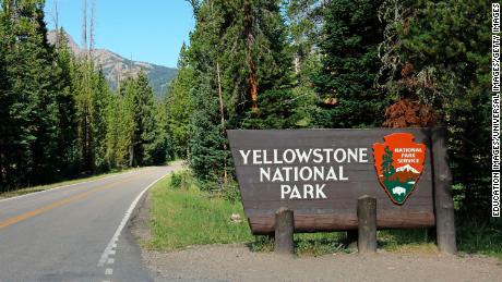
CaltransAlong Highway 80, for example, Alta is forecast to measure 6 to 8 inches, Donner Summit 18 to 24 and Truckee 12 to 18. On Highway 120, the Yosemite National Park entrance could record 12 to 18 inches, Tenaya Lake 24 to 30 and Tioga Pass 18 to 24.
The second storm arriving on Saturday is expected to bring another few feet of snow, said Rowe. “The highest elevations may see up to 5 feet combined across both storms,” he said. “At pass level, we’ll see 3 to 4 feet across those two storms.”
Mosquito Fire fouls air quality, turns Tahoe skies orange
The Mosquito Fire burning in Placer and El Dorado counties torched buildings in Volcanoville. California’s heat wave is waning, but the risk of new fires starting and spreading quickly will persist. Gov. Gavin Newsom declared a state of emergency in Placer and El Dorado counties due to the Mosquito Fire and in Riverside County due to the Fairview Fire.
We’ll be reporting on all the latest news on the Mosquito Fire and other major California wildfires throughout the day.
Little wind reported at the Mosquito Fire’s start
Weather readings clocked wind gusts at 4 mph when the Mosquito fire was first reported at 6:22 p.m. Tuesday. The temperature was 97 degrees at a weather gauge near Foresthill Union Elementary school, down from an earlier high of 101.
Placer County firefighters were already battling a new fire that started earlier Tuesday and several miles north. The Hill Fire reached about 11 acres and led authorities to evacuate people out of the Giant Gap, Big Reservoir, Shirttail Creek and Morning Star Lake campgrounds.
Berkeley says Mosquito Fire is threatening the Blodgett Forest Research Station
Berkeley Forests staff said on Friday that they have confirmed with on-the-ground fire personnel that the Mosquito Fire is burning within the boundaries of Blodgett Forest Research Station.
All Blodgett Forest personnel were evacuated and marked safe before the fire entered the property. “Although the fire has not yet burned in this area, it will likely reach this portion of the property in the coming day,” the agency said in a bulletin. “Fire personnel have indicated that structure protection is their priority at this time.”
Abysmal air quality turns skies orange in Tahoe region
Ash and particulate matter coming off the fast-moving Mosquito fire has turned air quality hazardous and painted skies a hazy orange.
AlertWildfire cameras show shades of orange, pink and gray covering the North Tahoe region and closer to where the wildfire is burning in Placer and El Dorado counties.
An Alertwildfire camera shows an eerily orange sky north of Auburn, Calif. on September 9, 2022.
Wildfire Camera/AlertwildfireAs a result of the extreme fire behavior small particles of dust, soot and ash are capitulated into the air. In the regions surrounding the blaze air quality index levels are more than 300, which can trigger serious health effects.
The extreme scene comes two years after dozens of lightning-sparked wildfires burned throughout the state, skies turned an apocalyptic-orange in places far from the flames, like San Francisco.
Hurricane Kay producing extreme weather in California
Hurricane Kay remnants are likely to bring tropical-like humidity to the Bay Area over the weekend, with a possibility of some rain, but in Southern California the tropical system is kicking up extreme weather.
Kay is moving northward off the coast of the Baja California peninsula and has already brought upwards of two-tenths of an inch of rain to San Diego County’s Laguna Mountains and the Cleveland National Forest. There are risks for torrential downpours and flash flooding in the coming days for the canyon passes and roadways near cities like Murrieta and Escondido.
Highway 193 shut down due to Mosquito Fire
California State Route 193, which runs through Placer and El Dorado counties, has been closed due to the Mosquito Fire, according to an update from Caltrans. The expected reopening time for the highway, which is located inside the mandatory evacuation area, is unknown at this time. “Please avoid the area if possible to allow emergency crews access,” the agency said.
Mosquito Fire explodes to nearly 30,000 acres
The Mosquito Fire burning in Placer and El Dorado counties grew to 29,585 acres in size late Friday morning, according to information posted by the U.S. Forest Service.
Wildfire smoke, cloud cover could reduce solar production up to 60%
The grid could see up to a 60% reduction in solar production — about 5,000 to 6,000 megawatts — due to wildfire smoke and cloud cover Friday, grid operator COO Mark Rothleder said in a Friday morning press call.
On Thursday, the grid saw a 30% reduction in solar production — about 3,000 to 4,000 megawatts — because of cloud cover and smoke, Rothleder said. Demand peaked Thursday around 48,300 megawatts, significantly lower than the 50,000+ megawatts of demand seen in prior days of the heat wave.
Demand is expected to peak Friday at 46,118 megawatts, with the grid having current capacity of 54,739 megawatts, as of 10:50 a.m.
Forestville couple forced to flee Mosquito Fire fears for fate of their home, and their cats
As the Mosquito Fire sparked and then exploded into a massive inferno in California’s Gold Country foothills Wednesday, Mary Garbe was celebrating her 68th birthday in her Forestville mobile home, the fire was heavy on her mind.
But when local Sheriff deputies arrived the next day urging them to evacuate, she told her husband, Ken, 72, she wouldn’t go.
Their seven cats, including five kittens, still hadn’t returned home. She didn’t want to leave them behind.
“I’m not going,” she told her husband, Ken. “They’re going to have to handcuff me.”
By Friday morning, the smoke grew heavier, the air choking them as the temperatures pushing into triple digits and her husband convinced her to leave.
“I just kept yakking at her,” he said. They left their front door open, in hopes the cats would return, grabbed their important documents, a safe filled with the last of their money and headed to the Baptist church in Auburn which had opened as an evacuation center, joining thousands of residents forced to flee their homes.
Mary wondered about her cats.
“I miss them,” she said.
Ken worried about the home.
“We’re going to be homeless if the trailer burns out, and 72 is too old to be homeless,” her husband said.
Federal grants available for Mosquito Fire
Gov. Gavin Newsom today said California has received a Fire Management Assistance Grant from the Federal Emergency Management Agency to support local agencies as they battle the Mosquito Fire. The grants “enable local, state and tribal agencies to apply for 75-percent reimbursement of their eligible fire suppression costs,” Newsom’s office said.
Wildfire smoke to push into Bay Area today and Saturday
Smoke from the Mosquito Fire has made it over to the Bay Area, bringing hazy skies with it.
“Today it’ll start to disperse out a little bit, but tonight we’ll get higher concentrations of smoke coming back into the Bay Area,” said National Weather Service meteorologist Sarah McCorkle.
Tropical Storm Kay in southern California has changed wind patterns to east-west, carrying the smoke from Mosquito Fire to the Bay Area, McCorkle said. The smoke could start veering north Saturday, McCorkle said.
Most of the smoke is at elevated levels, McCorkle said. Currently, air quality in the Bay Area ranges from “Good” to “Moderate” on the Air Quality Index, according to AirNow, a service operated by the Environmental Protection Agency.
“Terrible, no good, very bad air quality” across California
The Mosquito Fire is causing “terrible, no good, very bad air quality” across California’s Central Valley, according to Jeff Beamish, a meteorologist at Sonoma Tech. As of 9:45 am, he said that most regulatory and retail air monitors reported an unhealthy air quality index score from the region east of downtown Sacramento to Lake Tahoe. Cal Fire officials said they have been unable to accurately map the fire perimeter due to smoke conditions
Some 2,000 structures threatened by Mosquito Fire in El Dorado County
El Dorado County reports 2,000 structures imminently threatened by the Mosquito Fire, with another 11,500 in warning zones, with more than 17,000 residents affected. The fire continues to be fast-moving, forcing one evacuation shelter, Cool Community Church, to close after it fell into the evacuation warning zone.
Placer Sheriff reports 100-foot flames in Mosquito Fire
Flames as high as 100 feet shot through the trees as the Mosquito Fire tore through Foresthill, according to an update from the Placer Sheriff . “Fire crews worked hard to knock them down,” the office said in a tweet.
The fire has now expanded to 14,250 acres and is 0% contained, Cal Fire said. The fire has quadrupled in size and spread across El Dorado and Placer counties. “Assigned personnel continued to improve existing control line and build new control lines, and also assessed and prepared structures threatened by the fire,” the agency said in an update Friday. “The fire is burning in extremely difficult terrain including steep canyons where directly attacking the fire can be difficult.”
Hazardous air quality recorded near Mosquito Fire’s perimeter
Air quality index levels are fast-approaching 300 and above around the Mosquito Fire perimeter Friday morning, while more scattered 150-200 (unhealthy) levels are being measured all along the Northern Sierra. Prevailing winds at the higher levels of the atmosphere (15-20,000 feet) will shift and become easterly winds this afternoon thanks to the remnants of Kay to our south. This is important because the core of the pyrocumulus clouds fanning smoke from the fire are around that height.
So we can expect some of the particulates from the smoke to waft into the Sacramento Valley and parts of the Bay Area, decreasing air quality further on Friday.
The Chronicle’s Air Quality map showed unhealthy and very unhealthy air ringing Lake Tahoe as a result of the Mosquito Fire.
The ChronicleUnhealthy air swirls around Lake Tahoe
The Chronicle’s Air Quality map showed unhealthy — and in some places, very unhealthy — air quality around Lake Tahoe, likely due to the smoke billowing off the Mosquito Fire.
Patches of unhealthy or very unhealthy air were recorded across a vast swath of Northern California northeast of Sacramento.
Hellish images show Mosquito Fire raging across multiple counties
Images captured by wildfire cameras showed hellish plumes of smoke created by the fast-moving Mosquito Fire. Persistent hot, dry conditions were expected to help the fire grow at a rapid pace overnight.
Newsom declares state of emergency due to wildfires
Gov. Gavin Newsom declared a state of emergency in Placer and El Dorado counties due to the Mosquito Fire and in Riverside County due to the Fairview Fire on Thursday afternoon. Both wildfires are threatening multiple communities and have forced the evacuation of tens of thousands of residents. The declaration frees up state resources to help residents affected by the fire and to help firefighters battle the fires.
Kiely Rodni search in Lake Tahoe region leads to arrest of sex offender
The exhaustive search for missing California teen Kiely Rodni led to the arrest of a sex offender on unrelated charges, authorities said.
The arrest was made Thursday as police were conducting a sweep of sex offenders in Lake Tahoe region as part of their investigation into the missing person case that has gained national attention.
The sex offender compliance checks “resulted in several sex registrants being found in violation of their terms”, the Placer County Sheriff’s Office said Friday.
One offender was arrested, and criminal charges were pending against another, according to officials.


Rodni, 16, was last seen at a campground party with several hundred other young revelers in the Tahoe National Forest on Aug. 6.
She had been drinking and was likely too intoxicated to get behind to drive home, 18-year-old partygoer Sami Smith told Fox News Digital.
Detectives have interviewed less than half of the party attendees, Placer County Sheriff spokeswoman Angela Musallam reportedly said.
Many of the partygoers have remained tight-lipped over fear they would be charged over “illegal activity,” according to authorities.
“Although our detectives have interviewed over 100 partygoers, they would still like some more cooperation,” Musallam told the outlet.
None of the potential witnesses interviewed by police saw the early high school graduate leave the party, officials said.
Rodni’s phone last pinged around 12:30 a.m. at a clearing in the woods near the site of the massive outdoor shindig in Truckee, and her 2013 Honda CRV remained unaccounted for, cops said.

Officials announced Monday that they would scale back the “astronomical” search for the teen after investigators logged some 9,000 hours combing the region by land, air and lake.
“We are moving into a more limited but continuous search and rescue effort,” Nevada County Sheriff’s Capt. Sam Brown explained.
Structure Fire That Spread To Vegetation In Tahoe National Forest Near Camptonville Prompts Evacuation Order – CBS Sacramento
YUBA COUNTY (CBS13) – The latest on the Golden Fire burning in Yuba County:
12:44 p.m.
Firefighters are reporting that they have stopped the forward progress of the Golden Fire.
Cal Fire’s Nevada-Yuba-Placer Unit is helping in the incident, which is burning in the Tahoe National Forest.
The fire has grown to 25 acres, but Cal Fire says forward progress is now stopped.
10:36 a.m.
An evacuation order is now in effect for one area near the wildfire, which has also now grown to 10-15 acres.
The Yuba County Office of Emergency Services says anyone residing in Zone YUB-E012-A should immediately evacuate.
People in Zone YUB-E097 are also being urged to prepare to evacuate at a moment’s notice.
Camptonville Union Elementary School says, while the evacuation zone is south of them, they have decided to evacuate students as a precaution. Officials say the decision to evacuate was also made so that families have time to pick up students before more road closures happen.
9:11 a.m.
Crews are battling a wildfire in the Tahoe National Forest in Yuba County as gusty winds hit the region on Friday.
The wildfire is burning near the Golden Chain Highway and Highway 49, just south of Camptonville.
Firefighters say the incident started as a structure fire that spread into nearby vegetation. An estimated 5 acres have burned so far, according to the US Forest Service.
Due to the smoke causing some problems, Highway 49 has been closed from Marysville Road to Ridge Road.
No evacuations have been ordered at this point, Yuba County officials say.
People are being urged to stay out of the area.
A Red Flag Warning is in effect for Northern California through most of Friday.
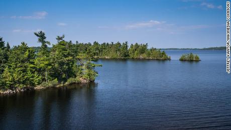
No sea serpents, mobsters but Tahoe trash divers strike gold
STATELINE, Nev. (AP) — They found no trace of a mythical sea monster, no sign of mobsters in cement shoes or long-lost treasure chests.
But scuba divers who spent a year cleaning up Lake Tahoe’s entire 72-mile (115-kilometer) shoreline have come away with what they hope will prove much more valuable: tons and tons of trash.
In addition to removing 25,000 pounds (11,339 kilograms) of underwater litter since last May, divers and volunteers have been meticulously sorting and logging the types and GPS locations of the waste.
The dozens of dives that concluded this week were part of a first-of-its-kind effort to learn more about the source and potential harm caused by plastics and other pollutants in the storied alpine lake on the California-Nevada line.
It’s also taken organizers on a journey through the history, folklore and development of the lake atop the Sierra Nevada that holds enough water to cover all of California 14 inches (36 centimeters) deep.
The Washoe Tribe fished the turquoise-blue Tahoe for centuries before westward expansion in the mid-1800s brought railroads, timber barons and eventually Gatsby-like decadence to what became a playground for the rich and famous.
Tahoe’s first casino was built in 1902 by Elias J. “Lucky” Baldwin, who owned a big chunk of east Los Angeles and built the prominent Santa Anita horse track in 1907. Massive lakefront estates followed for decades, including one used for the filming of “Godfather II.”
Cleanup organizers say one of the things locals ask most is whether they’ve found any gangsters’ remains near the north shore. That’s where Frank Sinatra lost his gaming license for allegedly fraternizing with organized crime bosses at his Cal-Neva hotel-casino in the 1960s.
The recovered debris mostly has consisted of things like bottles, tires, fishing gear and sunglasses.
But Colin West, founder of the nonprofit environmental group that launched the project, Clean Up the Lake, said there have been some surprises.
Divers think they spotted shipwreck planks near Dead Man’s Point, where tribal tales tell of a Loch-Ness-Monster-like creature — later dubbed “Tahoe Tessie″— living beneath Cave Rock.


They’ve also turned up a few “No Littering” signs, engine blocks, lamp posts, a diamond ring and “those funny, fake plastic owls that sit on boats to scare off birds,” West said.
“It’s shocking to see how much trash has accumulated under what appears to be such a pristine lake,” said Matt Levitt, founder and CEO of Tahoe Blue Vodka, which has contributed $100,000 to the cleanup.
His businesses is among many — including hotels, casinos and ski resorts — dependent on the 15 million-plus people who visit annually to soak up the view Mark Twain described in “Roughing It” in 1872 as the “fairest picture the whole earth affords.”
“It is our economic engine,” Levitt said.
And while most contributors and volunteers were motivated primarily to help beautify the lake, it’s what happens once the litter is piled ashore that excites scientists.
Shoreline cleanups have occurred across the nation for years, from Arizona to the Great Lakes, Pennsylvania and Florida. But that litter goes into recycle bins and garbage bags for disposal.
Each piece from 189 separate Tahoe dives to depths of 25 feet (8 meters) was charted by GPS and meticulously divided into categories including plastic, metal and cloth.
Plastics are key because international research increasingly shows some types can break down into smaller pieces known as microplastics.
Scientists are still studying the extent and human harm from the tiny bits. But the National Academy of Sciences said in December the U.S. — the world’s top plastics-waste producer — should reduce plastics production because so much winds up in oceans and waterways.
Zoe Harrold, a biochemist, led scientists at the Desert Research Institute in Reno that first documented microplastics in Tahoe in 2019. She was the lead author of Clean Up the Lake’s 2021 report on a 6-mile (10-kilometer) pilot project.
“If left in place, the ongoing degradation of submerged litter, particularly plastic and rubber, will continue to slowly release microplastics and leachates into Lake Tahoe’s azure waters,” Harrold wrote.
The cleanup comes a half-century after scientists started measuring Tahoe’s waning clarity as the basin began to experience explosive growth.
Most credit, or blame, completion of the interstate system for the 1960 Winter Olympics near Tahoe City. The first ever televised, it introduced the world to the lake surrounded by snow-covered peaks.
From 1960-80, Tahoe’s population grew from 10,000 to 50,000 — 90,000 in the summer, the U.S. Geological Survey said. Peak days now approach 300,000.
“The majority of what we’re pulling out is a result of basically just the human impact of recreating, living and building a community here in the Lake Tahoe region,” West said.
His group plans dives this year at other Sierra lakes, including June Lake east of Yosemite National Park, and will expand future Tahoe searches to deeper depths.
The non-profit Tahoe Fund, which also helped raise $100,000 for the cleanup effort, is commissioning artists to create a sculpture made from Tahoe’s trash at an events center being built in Stateline, on the lake’s south shore.
“Our hope is that it will inspire greater environmental stewardship and remind those who love Lake Tahoe that it’s up to all of us to take care of it,” Tahoe Fund CEO Amy Berry said.
No sea serpents, mobsters but Tahoe trash divers strike gold
STATELINE, Nev. (AP) — They found no trace of a mythical sea monster, no sign of mobsters in cement shoes or long-lost treasure chests.
But scuba divers who spent a year cleaning up Lake Tahoe’s entire 72-mile (115-kilometer) shoreline have come away with what they hope will prove much more valuable: tons and tons of trash.
In addition to removing 25,000 pounds (11,339 kilograms) of underwater litter since last May, divers and volunteers have been meticulously sorting and logging the types and GPS locations of the waste.
The dozens of dives that concluded this week were part of a first-of-its-kind effort to learn more about the source and potential harm caused by plastics and other pollutants in the storied alpine lake on the California-Nevada line.
It’s also taken organizers on a journey through the history, folklore and development of the lake atop the Sierra Nevada that holds enough water to cover all of California 14 inches (36 centimeters) deep.
The Washoe Tribe fished the turquoise-blue Tahoe for centuries before westward expansion in the mid-1800s brought railroads, timber barons and eventually Gatsby-like decadence to what became a playground for the rich and famous.
Tahoe’s first casino was built in 1902 by Elias J. “Lucky” Baldwin, who owned a big chunk of east Los Angeles and built the prominent Santa Anita horse track in 1907. Massive lakefront estates followed for decades, including one used for the filming of “Godfather II.”
Cleanup organizers say one of the things locals ask most is whether they’ve found any gangsters’ remains near the north shore. That’s where Frank Sinatra lost his gaming license for allegedly fraternizing with organized crime bosses at his Cal-Neva hotel-casino in the 1960s.
The recovered debris mostly has consisted of things like bottles, tires, fishing gear and sunglasses.
But Colin West, founder of the nonprofit environmental group that launched the project, Clean Up the Lake, said there have been some surprises.
Divers think they spotted shipwreck planks near Dead Man’s Point, where tribal tales tell of a Loch-Ness-Monster-like creature — later dubbed “Tahoe Tessie″— living beneath Cave Rock.
They’ve also turned up a few “No Littering” signs, engine blocks, lamp posts, a diamond ring and “those funny, fake plastic owls that sit on boats to scare off birds,” West said.
“It’s shocking to see how much trash has accumulated under what appears to be such a pristine lake,” said Matt Levitt, founder and CEO of Tahoe Blue Vodka, which has contributed $100,000 to the cleanup.
His businesses is among many — including hotels, casinos and ski resorts — dependent on the 15 million-plus people who visit annually to soak up the view Mark Twain described in “Roughing It” in 1872 as the “fairest picture the whole earth affords.”
“It is our economic engine,” Levitt said.
And while most contributors and volunteers were motivated primarily to help beautify the lake, it’s what happens once the litter is piled ashore that excites scientists.
Shoreline cleanups have occurred across the nation for years, from Arizona to the Great Lakes, Pennsylvania and Florida. But that litter goes into recycle bins and garbage bags for disposal.
Each piece from 189 separate Tahoe dives to depths of 25 feet (8 meters) was charted by GPS and meticulously divided into categories including plastic, metal and cloth.
Plastics are key because international research increasingly shows some types can break down into smaller pieces known as microplastics.
Scientists are still studying the extent and human harm from the tiny bits. But the National Academy of Sciences said in December the U.S. — the world’s top plastics-waste producer — should reduce plastics production because so much winds up in oceans and waterways.
Zoe Harrold, a biochemist, led scientists at the Desert Research Institute in Reno that first documented microplastics in Tahoe in 2019. She was the lead author of Clean Up the Lake’s 2021 report on a 6-mile (10-kilometer) pilot project.
“If left in place, the ongoing degradation of submerged litter, particularly plastic and rubber, will continue to slowly release microplastics and leachates into Lake Tahoe’s azure waters,” Harrold wrote.
The cleanup comes a half-century after scientists started measuring Tahoe’s waning clarity as the basin began to experience explosive growth.
Most credit, or blame, completion of the interstate system for the 1960 Winter Olympics near Tahoe City. The first ever televised, it introduced the world to the lake surrounded by snow-covered peaks.
From 1960-80, Tahoe’s population grew from 10,000 to 50,000 — 90,000 in the summer, the U.S. Geological Survey said. Peak days now approach 300,000.
“The majority of what we’re pulling out is a result of basically just the human impact of recreating, living and building a community here in the Lake Tahoe region,” West said.
His group plans dives this year at other Sierra lakes, including June Lake east of Yosemite National Park, and will expand future Tahoe searches to deeper depths.
The non-profit Tahoe Fund, which also helped raise $100,000 for the cleanup effort, is commissioning artists to create a sculpture made from Tahoe’s trash at an events center being built in Stateline, on the lake’s south shore.
“Our hope is that it will inspire greater environmental stewardship and remind those who love Lake Tahoe that it’s up to all of us to take care of it,” Tahoe Fund CEO Amy Berry said.
70-mile stretch of I-80 in Sierra closed due to Tahoe snowstorm
Whiteout conditions have closed a 70-mile stretch of Interstate 80 in the Sierra as a blustery Christmas weekend storm dumps snow on the Tahoe area.
As of Sunday morning, I-80 remains closed from Colfax to the Nevada state line with no reopening in sight. To the north, State Route 49 is closed from Camptonville to Sierraville. Highway 50 is closed from Echo Summit to Meyers due to “multiple spinouts,” Caltrans said.
Roads all over the Sierra are currently considered dangerous for drivers, with low visibility, high winds and snow. Even on roads that are not closed, Truckee and Tahoe fire departments have been reporting spinouts throughout the weekend. If you must take to the roads, chains are required.
“Wondering why I-80 is currently closed?” CHP Truckee tweeted on Christmas morning, accompanied by a video so snowy that no road could be discerned. “Here’s what I-80 looks like right now.”
A winter storm warning is in effect throughout the Greater Lake Tahoe area until 1 a.m. Tuesday. Heavy snow and wind gusts up to 45 mph are forecast, with “widespread whiteout conditions.”
“Travel could be very difficult to impossible. The hazardous conditions could impact the morning or evening commute. Very strong winds could cause extensive tree damage,” the National Weather Service cautioned. “Roads and highways may be closed for extended periods of time.”
The weather service says travel should be avoided if possible, as “you could be stuck in your vehicle for many hours.” Those who must travel should “prepare for long delays and carry an emergency kit with extra food, water and clothing.”
Interstate 80 was closed from Colfax in Placer County to the Nevada state line due to whiteout conditions.
Caltrans District 3 / TwitterSome Tahoe ski resorts saw 2 feet of snow on Saturday — with more on the way. Twenty inches fell on Homewood on the west shore, while Northstar received a foot of snow from Friday night into Saturday. The weather service is forecasting additional snow accumulations of 1 to 2 feet through early Tuesday, and 2 to 3 feet in elevations above 7,000 feet.
You can check the latest road closures here.
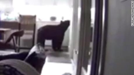
Video captures bear walking into Tahoe 7-Eleven store
Maybe it wanted a Klondike Bar.
A large bear opened the door of a 7-Eleven store in Tahoe’s Olympic Valley near Palisades resort with his paw this week and casually walked into the store, putting his two front legs up on a freezer at the door.
The furry beast never made it to the ice cream aisle, but the animal showed its manners by triggering the hand sanitizer dispenser with its snout and keeping 6 feet distance.
TikTok user @fmunna83pk took video of the incident, with a woman in the background screaming “get out,” and the footage posted on Nov. 14 has received more than 1.2 million hearts and more than 55,000 comments.
Even 7-Eleven, the American chain of convenience stores, hopped into the comments and joked, “he wants a blue raspBEARy Slurpee.”
The store at 3041 River Road confirmed the animal has been spotted multiple times in the parking lot but had never been inside. No one was harmed and animal control was called, but the store said the bear ran away before officials arrived.
Kevin Thomas, a regional manager for the California Department of Fish and Wildlife, said the bear has an ear tag on it, which means it has been captured and marked during one of the efforts over the past few years to trap and tag bears in the Tahoe Basin.
“The behavior is not typical of wild bears,” Thomas wrote in an email. “It is a learned behavior from pursuing human food sources rather than foraging in the wild. Lake Tahoe has a robust bear population and they often interact with homes and businesses in search of food. Once they get a taste of human food it can be difficult to reverse the behavior. Part of the trap/tag/haze effort we operate is to try and recondition those bears to pursue natural food sources.”
Bears in the Tahoe Basin are known for their antics, and over the years, the animals have learned they can come down from higher elevations and find food in the towns and neighborhoods. Unsecured dumpsters are a favorite, but sometimes they also break into cars and enter residences and stores.
Another Tahoe bear made headlines in 2020 by entering a Safeway store and feasting in the produce aisle. The same bear was also spotted in a convenience store at a nearby gas station stuffing candy into its mouth.
Peter Tira, an information officer for the California Department of Fish and Wildlife, said fall is a time of year when bears are actively seeking food and people should be extra vigilant about not leaving food in cars or out in cabins.
“This is a time of year when Tahoe bears are undergoing a physiological change,” Tira explained. “They are in eating overdrive, fattening up for winter and hibernation. It’s nature’s way of preparing them for winter. We’re seeing lots of bears breaking into cars. Folks have to be vigilant on their properties, campsites and cars. It’s a time when bears are out actively out foraging aggressively.”
If you’re visiting Tahoe and concerned about bears, read SFGATE Tahoe editor Julie Brown’s story on “things you should know about bears.”
Woman battling cancer survives a bear attack in her Lake Tahoe cabin
Laurel-Rose von Hoffmann-Curzi was woken up early on October 30 by a series of thumping sounds downstairs in her family’s Tahoe Vista cabin.
At first she thought her son was being noisy, but as she came down the stairs she realized that there was a large bear rummaging in her freezer and throwing food on the ground.
It was still dark, but the bear was illuminated by the light from the freezer.
“About the time I recognized that he was a bear, he recognized, I guess, that I was a person and came charging at me,” the 66-year-old retired doctor told CNN.
Von Hoffmann-Curzi says she didn’t really see the bear charge because it all happened so fast.
“I remember seeing his big paw right on my face and basically nothing else,” she said. “And I started feeling my body being ripped apart.”
She said she was “screaming and screaming and screaming” as the bear attacked.
The bear came up the stairs at her a second time and von Hoffmann-Curzi says she threw a quilt and a robe that landed on its head and spooked the animal.

The bear came towards her a third time but ran out of the house when von Hoffman-Curzi’s husband and son came out of their rooms.
Her husband helped tend to her wounds while her son called 911. She says help arrived in less than 10 minutes and she was rushed to the hospital.
Von Hoffman-Curzi says her face hurt the worst and she was bleeding a lot. But she also had scratches and other wounds on her neck, back, arm and other parts of her body, along with a bite near her left breast.
There was also a deep puncture wound on her abdomen that she feared had ruptured her spleen, which she says would have been disastrous because she is going through chemotherapy for lymphoma.
Von Hoffman-Curzi was transferred to the UC Davis Medical Center in Sacramento for more treatment. The surgeon there “did a spectacular job” stitching up her extensive facial injuries, she said.
Doctors gave von Hoffmann-Curzi antibiotics in hopes of preventing infections and abscesses, because she’s immunocompromised and because bears carry bacteria.
Von Hoffman-Curzi hopes she won’t need additional surgeries.
She lives in Orinda, California, in the Bay Area, and says she and her husband go to the cabin fairly regularly, because it’s one of the few places she can go outside of her home.
Her chemotherapy has made her very susceptible to Covid-19, so it hasn’t been safe for her to be out and about during the pandemic even though she’s vaccinated.
“The only reasons are doctors appointments and chemotherapy,” she said. “That’s my social life is going to chemotherapy.”
She says they won’t go back until this bear is caught.
“It would be dangerous for us because the bear knows the cabin, knows there’s food there, knows how to get in [and] is unafraid of people,” she said.
Capt. Patrick Foy with the California Department of Fish and Wildlife says authorities have set up a trap at the cabin to try to catch the bear. They also took DNA samples from Von Hoffman-Curzi’s wounds and from inside the cabin.
The bear will have to be euthanized if they catch it, and they’ll use the DNA information to make sure they have the right one, Foy says. Any other bears they capture will be released in a safe location.
California black bears are the only type of bear that lives in the wild in California. An estimated 25,000 to 30,000 live in the state. Adult females can weigh from 100 to 200 pounds and males are even bigger, between 150 and 350 pounds.
Foy says that many of the bears around Tahoe, which he described as an urban-rural interface, have become accustomed to humans.
“When you have bears that are breaking into homes, those are bears that are fairly habituated to these urban areas, and that’s the way they make a living really is by by pursuing human sources of food,” he said. “I don’t mean humans as a source of food, just human sources of food.”
He says this was the second bear attack on a human this year.
Von Hoffmann-Curzi says they had just gotten to the cabin on Friday night and hadn’t cooked or eaten any food, or generated any trash.
She thinks the bear may have smelled some avocados that they brought with them.
They didn’t lock their deadbolt that night, von Hoffman-Curzi says, and the bear was able to open the door with its paws.
“These bears are super-smart,” she said.
Foy recommended residents and visitors to the area go to keepmewild.org for tips on how to avoid negative encounters with bears and other wildlife. He said they get reports almost daily of bears getting into people’s homes or vehicles, getting into trash, busting open bird feeders and causing other property damage while hunting for food.