CHICAGO (WLS) — The Chicago weather forecast this week shows a significant winter storm that has the potential to dump upwards of a foot of snow before Christmas.
The National Weather Service has issued a Winter Storm Watch for the entire Chicago area and northwest Indiana from 6 p.m. Thursday to 6 a.m. Saturday.
ABC7 Meteorologist Tracy Butler says some light snow could begin Thursday afternoon, with heaviest snow coming Thursday night into the day on Friday.
High winds and frigid temperatures will also lead to blizzard-like conditions Thursday night into Friday morning.
Butler said the storm could bring a potential of 6 to 12 inches of snow by the weekend, with higher amounts possible further east from lake-effect snow.
WATCH | Latest 7-day Chicago weather forecast
High winds in excess of 55 mph are expected while the heaviest snow is falling, ABC7 Meteorologist Larry Mowry said, adding that he expects the Winter Storm Watch will be upgraded to a Winter Storm Warning or Blizzard Warning later in the week.
“The concern will be not only the snow that’s coming down, but the blowing snow, which will reduce visibility,” Mowry said. “And because the winds will be this strong, there is the threat of power outages Thursday night through the day on Friday.”
POLAR PLUNGE | 1st week of winter brings snow and bitterly cold temperatures
Mowry said the heavy snow and high winds will combine to create major travel impacts, with “extremely difficult to impossible travel from Thursday night through the day on Friday.”
Temps will also crash from the teens on Friday to single-digits over the weekend, with the high winds creating dangerously cold conditions. Friday will starts with wind chills as low as -20 and -30, and will stay well below zero through the day, Mowry said.
The forecast for this week has forced many holiday travelers to scramble to change their plans. Most airlines currently have weather waivers in place, which means you can change your flights for free if you have flexible travel plans.
Stay tuned to ABC7 Eyewitness News and ABC7Chicago.com for the latest forecast and snowfall amounts as the winter storm approaches.
Cook County Radar DuPage County Radar Will County Radar Lake County Radar (IL) Kane County Radar Northwest Indiana Radar
Moscow (AFP) – Heavy snowfall descended on the Russian capital on Sunday, disrupting traffic, delaying flights and leaving pavements buried with snow.
In parts of Moscow, snow piled into mounds over 30 centimetres (12 inches) high, something not usually observed until the end of winter in February, the Fobos weather centre said.
The last time a similar depth of snow was recorded in Moscow in mid-December was in 1989 and in 1993, Fobos added.
Close to 119,000 people and over 12,500 vehicles were deployed to clear the snow, according to Moscow city authorities, with snowfall forecast to continue until the evening.
“It’s a snow Armageddon: in Moscow there is such a storm that you can’t walk or drive,” state-controlled Channel One said in a report.
Pavements in some parts of the capital were left completely covered in snow with snow-clearing equipment prioritising roads to ease the heavily congested traffic.
Air traffic was also affected with over 50 flights either delayed or cancelled at Moscow airports.
BUFFALO, New York (WABC) — President Joe Biden has approved a federal emergency declaration for 11 New York counties after historic levels of lake-effect snow buried the region over the weekend.
The storm set a state record for the most snowfall within a 24-hour period, with some parts of Erie County getting more than 6 feet of snow.
According to the National Weather Service, by 1 p.m. Sunday the highest total was recorded in Orchard Park, home to the Buffalo Bills, which saw a jaw-dropping 80 inches of snow.
That was followed by Athol Springs with 76″, Hamburg with 73.7″ and Natural Bridge with 72.3″.
The President’s emergency declaration authorizes the Department of Homeland Security, Federal Emergency Management Agency (FEMA), to coordinate all disaster relief efforts for residents who have been impacted.
WATCH | Walls of snow, diving into piles & more: New Yorkers show impact of historic snowfall:
The counties covered under the declaration are Cattaraugus, Chautauqua, Erie, Genesee, Jefferson, Lewis, Niagara, Oneida, Oswego, St. Lawrence and Wyoming.
“I thank President Biden for immediately granting our emergency declaration request and for our ongoing strong partnership as well as Senator Schumer for his assistance in securing relief for New Yorkers,” Governor Kathy Hochul said in a statement Monday. “My team and I will continue working around the clock to keep everyone safe, help communities dig out, and secure every last dollar to help rebuild and recover from this unprecedented, record-shattering, historic winter storm.”
Parts of the state finally caught a break Sunday after the storm pounded cities and towns east of Lake Erie and Lake Ontario.
Many businesses in the hardest-hit areas remained closed, but highways reopened and travel bans in many areas were lifted, though bands of lake-effect snow were expected to bring up to 2 feet (0.6 meters) by Monday morning in some parts of the state that were largely spared in earlier rounds.
“This has been a historic storm. Without a doubt, this is one for the record books,” Hochul said at a briefing on Sunday.
Snow began falling Thursday in towns south of Buffalo. By Saturday, the National Weather Service recorded 77 inches (196 cm) in Orchard Park and 72 inches in Natural Bridge, a hamlet near Watertown off the eastern end of Lake Ontario.
Hochul said teams were checking on residents of mobile home parks in areas that got enough snow to potentially crumple roofs.
Due to the heavy snowfall, the Sunday football game between the Buffalo Bills’ and Cleveland Browns was moved to Detroit.
New York is no stranger to dramatic lake-effect snow, which is caused by cool air picking up moisture from the warmer water, then releasing it in bands of windblown snow over land.
This month’s storm is at least the worst in the state since November 2014, when some communities south of Buffalo were hit with 7 feet (2 meters) of snow over the course of three days, collapsing roofs and trapping drivers on a stretch of the New York State Thruway.
The Associated Press contributed to this report.
ALSO WATCH: Weather Or Not with Lee Goldberg: Winter Weather Outlook
———-
* Get the AccuWeather App
* More AccuWeather
* Follow us on YouTube
* More local news
* Sign up for free newsletters
* Download the abc7NY app for breaking news alerts
Submit Weather Photos and Videos
Have weather photos or videos to share? Send to Eyewitness News using this form. Terms of use apply.
Heavy snowfall that has pounded parts of western New York state will persist into Friday, when the worst of the potentially historic storm may cause trees to topple and damage property.
“The snowfall will produce near zero visibility, difficult to impossible travel, damage to infrastructure, and paralyze the hardest-hit communities,” the National Weather Service said Thursday. “Very cold air will accompany this event, with temperatures 20 degrees below normal forecast by the weekend.”
“Historic snowfall exceeding 4 feet is likely around Buffalo,” it added Friday.
About 6 million people in five Great Lakes states – from Wisconsin to New York – are under snow alerts Friday, CNN Meteorologist Haley Brink said. Snow produced through lake effect will continue through Sunday in areas downwind of the Great Lakes, according to the National Weather Service.
In New York, places east of Lakes Erie and Ontario may see snowfall at a rate of more than 3 inches per hour, occasionally joined by lightning and gusty winds, the weather service warned.
“That level of snow coming down with that intensity is what creates the dangerousness the lack of ability to see on the roads,” New York Gov. Kathy Hochul said Thursday as she declared a state of emergency for 11 counties.
“When its coming down at that rate, it is almost impossible to clear the road to make it safe to travel,” Hochul said. “It will not be safe for a considerable amount of time for motorists to go back on the roads.”
Commercial traffic has been banned since Thursday afternoon on about 130 miles of the New York State Thruway (Interstate 90) in the Rochester and Buffalo area to the Pennsylvania border, Hochul’s office said. Other parts of major interstates – including 90, 290 and 990 – also have also been shut down,
Imploring residents to take caution this weekend, Hochul described the storm as a “major, major” snowfall event that could be as life-threatening as the November 2014 snowstorm that claimed the lives of 20 people in the Buffalo region.
Further, officials in New York’s Erie County – which includes Buffalo – also declared a state of emergency and banned driving beginning Thursday night.
“The lake effect snow from (the storm) is very heavy and may cause tree branches to fall and damage vehicles, property or powerlines. Watch where you park, and be aware of your surroundings if going outside,” Erie County officials wrote online.
The storm’s most intense snow is expected to lash the Buffalo area, where more than 4 feet could pile, making for a forecast not seen in more than 20 years. The city’s highest three-day snowfall is 56.1 inches, which occurred in December 2001, CNN Meteorologist Brandon Miller said.
Indeed, given the rate of snowfall, Buffalo may see a month’s worth of snow in only a few hours. That could make this month the snowiest November since 2000, when 45.6 inches in total fell in the city during the entire month, Miller added.
Already, residents of Williamstown in Oswego County near Lake Ontario saw 24 inches of snow as of Thursday evening, according to the weather service. In neighboring Oneida County, some spots were blanketed with 14 inches of snow in the 24 hours before Thursday evening, per the weather service.
Friday alone could bring more than 2 feet of snow, which would make it one of the top three snowiest days on record in Buffalo, according to Miller.
“Heavy lake effect snow off Lake Erie with 2-3” per hour snowfall rates will continue to result in extremely difficult travel this evening for the Buffalo Metro area east to Batavia, and also in Oswego County off Lake Ontario,” the National Weather Service in Buffalo said Thursday night.
“Additional accumulations of 2-3 feet of snow are expected downwind of lakes Erie and Ontario while 8-12” are likely downwind of the other 3 lakes by Sunday morning,” it added Friday.
Lake effect snow happens when very cold, windy conditions form over a relatively warm lake – meaning the lake might be 40 degrees while the air is zero degrees, Miller explained. The temperature clash creates instability, which allows for the most extreme winter weather to occur.
Due to the weather emergency, Sunday’s NFL game in Orchard Park, New York, between the Buffalo Bills and the Cleveland Browns has been moved to Detroit, the league announced Thursday.
Other areas affected by the storm include parts of the Upper Peninsula and the western Lower Peninsula of Michigan, where gusty winds and heavy snow will also cause near zero visibility and unsafe travel conditions.
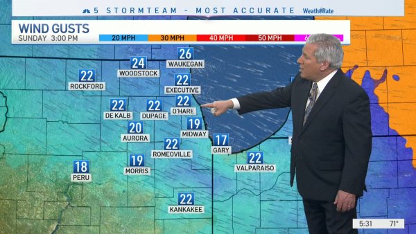
With up to four inches of snow expected through early Monday, Chicago-area drivers are urged to use caution ahead of what could possibly be a messy morning commute.
According to the National Weather Service, accumulating snowfall is expected late Sunday into early Monday, with an inch of snow per hour falling between 11 p.m. and 3 a.m.
As temperatures hover around freezing, a wintry mix of snow, rain and freezing drizzle is possible, with the potential for a “minor glaze” of ice, mainly between 4 and 8 a.m.
A winter weather advisory was issued for DeKalb, Kane, Lake, McHenry and northern Cook counties from midnight to noon Monday, warning of the possibility of anywhere from 2 to 4 inches of snow.
Less accumulation is expected in central and southern Cook County, as well as DuPage County. A separate winter weather advisory was issued for those areas, advising of wet snow accumulations from 1 to 3 inches.
Snow is likely for the morning commute, but will largely taper off in the late morning hours, forecasters said.
Some snow showers and sprinkles are possible in the afternoon, but will clear out before the evening rolls around, the NWS stated.
Weather
The region will see a short break from the winter weather as dry conditions set in for a little while.
Both Tuesday and Wednesday are expected to be dry before the next possibility of light snow Thursday.
CHICAGO (WLS) — Wednesday may feel spring-like with temperatures reaching into the 50s, but another winter storm is forecast to slam the area on Thursday.
The storm could dump four to seven inches of snow on parts of the area Thursday.
The National Weather Service has issued a Winter Storm Warning for southern Cook, Grundy, Kankakee, Kendall, La Salle, Livingston and Will counties in Illinois and Lake and Porter counties in Indiana from 3 a.m. until 9 p.m. Thursday.
WATCH: Full ABC7 AccuWeather 7-day Forecast
A Winter Weather Advisory will include northern and central Cook, DuPage and DeKalb counties will go into effect at 3 a.m. until 6 p.m. Thursday.
Wednesday will start with high winds and heavy rain, with rainfall amounts of .50 inch to 1.50 inches are possible.
Overnight, temperatures will drop to near freezing and the rain will transition over to an icy mix from around 3 a.m. to 10 a.m. Southern parts of the Chicago area could see some significant ice accumulation.
ABC7 Meteorogist Tracy Butler said there may be a break in the precipitation during the height of the morning rush before heavy snow moves in and continues through the afternoon and evening.
Click here to see school closings, moves to e-learning in the Chicago area
Areas under the Winter Storm Warning could see anywhere between four to seven inches of snow. Areas covered by the advisory could see two to four inches of snow and areas to the far north and west may see one to three inches of snow.
Stay tuned to ABC7 Eyewitness News and ABC7Chicago.com for the latest updates on the snow storm.
Cook County Radar | DuPage County Radar | Will County Radar | Lake County Radar (IL) | Kane County Radar | Northwest Indiana Radar
Roughly one million people across the Northeast were under winter weather alerts early Sunday, down from the nearly 16 million who were affected by such alerts Saturday night.
“That is a huge drop-off as the storm exits the most populous areas of the eastern seaboard,” CNN meteorologist Derek Van Dam said.
Blizzard warnings — which affected millions across multiple states Saturday — have also been scaled down to eastern and northern Maine, where more than 240,000 people were affected as of 1 a.m. Sunday, according to the National Weather Service (NWS).
A blizzard, as defined by the NWS, requires blowing or falling snow, winds of at least 35 miles per hour, and visibility of a quarter mile or less for at least three hours.
Those conditions were reached Saturday in several locations across Rhode Island and eastern Massachusetts, including Boston, the NWS said.
Wind speed — which reached more than 80 mph Saturday across eastern Massachusetts — is expected to ease to about 15-25 mph Sunday, though gusts could be higher in some local areas, according to Van Dam.
Sign up for weather email alerts
Still, much of the Northeast can expect “dangerous” wind chills, some dipping below zero Sunday morning as the storm exits the region, the NWS warned. More than 760,000 people from parts of western Virginia through Maine are under those warnings effective until 7 a.m. in some areas and 10 a.m. in others.
Later Sunday, some areas including Buffalo, New York, and Pittsburgh will see temperatures improve by roughly 10 degrees.
Meanwhile, cities including New York, Boston and Philadelphia will see a slight dip of about 4 degrees Sunday.
“Although temperatures are going to rebound (Sunday), we will have to be patient for any real warm up, which doesn’t come until the middle of the week,” Van Dam said.
The frigid cold follows dense snowfall that broke records throughout the Northeast in parts of southern New Jersey, New York, Pennsylvania and Massachusetts.
The storm became a “bomb cyclone” Saturday morning, meaning it strengthened rapidly and had the barometric pressure drop more than 24 millibars within 24 hours, the Weather Prediction Center said.
The storm wreaked havoc on transportation in the region, creating dangerous conditions on roadways and delays and cancellations on air and rail travel.
More than 3,580 flights within, into or out of the US were canceled Saturday, according to FlightAware, and more than a thousand were already canceled for Sunday as of the early morning. Major airlines offered waivers and alternative options to passengers whose travel was affected by the storm.
Record snow and roaring winds
The bomb cyclone brought heavy snow that accumulated quickly as howling winds blew through the region.
The town of Stoughton, Massachusetts, recorded a staggering 30.9 inches of snowfall by Saturday night, the NWS said. And winds in parts of Barnstable County, Massachusetts, where Cape Cod is located, reached 81 mph Saturday, the service said.
By Sunday morning, up to 2 feet of snow could fall from Long Island through Rhode Island, Massachusetts, New Hampshire and Maine, CNN forecasters said.
Here are some notable snowfall records:
Atlantic City, New Jersey: The city crushed its all-time January snowfall record by Saturday, reaching a monthly total of 33.2 inches of snow. The prior monthly record of 20.3 inches was set in January 1987. The city’s 14 inches of snow Saturday also beat its previous record for the calendar date, which was set in 2014 at 7.3 inches.
Boston: Logan International Airport tallied at least 23.6 inches of snow by Saturday night, said the NWS, making Saturday the snowiest January day Boston has recorded and tying the record for biggest 1-day snowfall total. The previous record was set on January 27.
Central Park, New York: The iconic park saw 7.3 inches on Saturday, beating the previous record for January 29 of 4.7 inches set in 1904.
Philadelphia: The city was hit with 5.8 inches of snow Saturday, beating the previous calendar day record of 5 inches set on January 29, 1904.
Power outages remain
The storm’s strong winds lead to downed power lines, leaving thousands still in the dark.
Nearly 65,000 homes and businesses in Massachusetts were without power early Sunday according to PowerOutage.us, down from more than 88,000 Saturday evening.
High winds and snow pushed over several trees across Nantucket Island while some areas were out of power because of downed wires, island Fire Chief Stephen Murphy told CNN Saturday afternoon. Several roadways were also closed because of flooding, the chief said.
“We do have coastal flooding when we get these kinds of storms, but today was pretty intense,” Jason Graziadei, an editor at the local newsletter Nantucket Current, told CNN. “People (are) kind of just hunkering down out here.”
Scituate, a coastal Massachusetts town southeast of Boston, had some mild to moderate flooding at high tide Saturday morning, with water splashing over seawalls, town administrator Jim Boudreau told CNN.
In Marshfield, another coastal Massachusetts town, about 4 feet of water came over the seawall at high tide, town administrator Michael A. Maresco told CNN.
CNN’s Jason Hanna, Christina Maxouris, Brynn Gingras, Brian Todd, Artemis Moshtaghian, Liam Reilly, Tyler Mauldin and David Williams contributed to this report.
PHILADELPHIA (WPVI) — The nor’easter that hit Friday night and into Saturday brought some impressive snowfall totals.
The National Weather Service has been collecting measurements from trained spotters and public reports all day long from across the Philadelphia region, including counties in Pennsylvania, New Jersey and Delaware.
The Jersey shore took the brunt of this storm. By mid-morning Saturday some communities were already reporting more than a foot of snow.
Even though the biggest impact was along the coast, the storm brought heavy snow throughout most of the Delaware Valley.
Some parts of Philadelphia had more than six inches of snow. Southern Delaware was also being hit hard, with at least one community reporting a foot of snow.
Local communities with more than a foot of snow far include:
NEW JERSEY
Atlantic County
Smithville: 16.1 in Atlantic City Int’l: 16.0 in Northfield: 15.0 in
Galloway Twp: 14.0 in Absecon: 13.5 in Egg Harbor City: 12.6 in Egg Harbor Twp: 12.6 in Estell Manor: 12.5 in
Northfield: 12.0 in Northfield: 12.0 in
Cape May County
Sea Isle City: 14.8 in Marmora: 14.0 in Lower Twp: 13.0 in Cape May Court House: 13.0 in Erma: 13.0 in Lower Twp: 13.0 in Goshen: 12.5 in
Ocean County
Bayville 19.0 in Forked River 16.0 in Manahawkin 16.0 in
Toms River 16.0 in Tuckerton 16.0 in Lanoka Harbor 15.0 in Brick 14.8 in Whiting 13.0 in
DELAWARE
Sussex County
Millsboro: 13.0 in Frankford: 12.5 in Millville: 12.5 in Lewes: 12.0 in Harbeson: 12.0 in
Check here for the full list of current snowfall totals from the NWS.
As many as 80 million people are under winter weather alerts from that region to the Northeast, CNN meteorologist Derek Van Dam said.
“I am particularly concerned for the impending ice storm that will impact the interior of South and North Carolina. Following a round of heavy snow, up to 3/4 of an inch of ice could accumulate,” Van Dam said.
“This will certainly bring power outages in the area as winds gust over 40 mph,” he added.
Greenville, South Carolina, and Charlotte and Raleigh in North Carolina are under winter storm warnings, forecasters said. As much as a foot of snow could fall near the edge of the Blue Ridge escarpment in Greenville and as much as 20 inches of snow could accumulate above 4,000 feet of elevation in that area. A tenth of an inch of ice is also possible.
The National Weather Service has issued an ice storm warning for portions of South Carolina, in effect through early Monday, with temperatures likely to remain sub-freezing until the start of next week.
“Significant amounts of ice accumulations will make travel dangerous or impossible. Travel is strongly discouraged,” according to the NWS office in Greenville.
Bookmark this site to check if snow is forecast for your region
Charlotte could get up to a foot of snow in the foothills, and possibly as much as a half-inch of ice. Raleigh is expected to get up to 2 inches of snow and maybe a quarter-inch of ice, forecasters said.
The NWS is warning that ice accumulations will become very dangerous along and east of I-85 including Spartanburg, South Carolina, all the way up to Salisbury, North Carolina. This includes the entire metro Charlotte area.“The highest snowfall totals are expected along the spine of the Appalachians as well as across the lower Great Lakes,” the National Weather Service said early Sunday.
“The most significant icing is expected over the Carolinas this morning. Significant impacts to travel across these regions are expected,” the NWS said.
Snowfall rates could top one inch per hour from northeast Georgia into the western Carolinas and far eastern Tennessee, the Storm Prediction Center said. Heavy snow will is also possible in western Virginia.
From the Mid-Atlantic through New England, the NWS said, “precipitation is forecast to begin as snow before changing over to ice/sleet and eventually rain with the approach of the storm center.”
The governors of Georgia, North Carolina, South Carolina and Virginia declared states of emergency, allowing resources to be positioned ahead of the storm’s arrival.
Parts of northern and central Georgia could also see powerful winds Sunday, the National Weather Service in Atlanta said.
“With strong winds and the potential for winter weather, we are highly concerned about downed trees and powerlines knocking out power through Sunday, so prepare now!” the service wrote on Twitter Saturday evening.
Georgia Gov. Brian Kemp ordered the state Department of Defense to prepare 1,000 National Guard troops to assist in the response to the storm.
Mid-Atlantic and Northeast
The storm will turn northeastward to the East Coast Sunday and Monday.
Some snow will fall in major metro areas, but a change to rain will hold down the accumulations. Washington could get 2-4 inches, while Philadelphia could get 1-2 inches. New York and Boston are expected to get about an inch each.
Heavier snow is expected elsewhere, with more than a foot expected in some locations.
“As is common with this storm track, the Shenandoah Valley back toward the Alleghenies will be the likely winners in terms of highest snowfall totals,” NWS Baltimore said Saturday. “7 to 10 inches is possible, but over a foot is not out of the question where heavier bands form.”
Snowfall intensity in the region may be heavy enough to evade significant icing, but NWS Baltimore warns that untreated surfaces may still lead to dangerous travel conditions where ice accumulates.
The majority of accumulating snowfall will occur Sunday afternoon through Monday morning.
Interior cities such as Charleston, Pittsburgh, Buffalo, Syracuse and Burlington, Vermont, will see the heaviest snow.
Prior to the snow event moving into the region, the Northeast will experience cold temperatures and dangerous wind chill, forecasters said.
Coastal flooding also expected
Alongside the snowfall potential, strong winds from the east associated with the storm system could cause major coastal flooding of up to 3 feet above ground in some areas along the Northeast coast during high tide.
Parts of New York City, Long Island and some areas of Connecticut are under coastal flood warnings, forecasters said.
The timing of winds shifting from the east to the south will largely determine the severity of flooding, with moderate flooding potential if winds shift prior to high tide.
“Widespread moderate to locally major flooding of vulnerable areas is possible near the waterfront and shoreline, including roads, parking lots, parks, lawns, and homes and businesses with basements near the waterfront,” the NWS in New York said Saturday.
Inundation could cause road closures and structural damage along the Atlantic coastline.
CNN meteorologists Allison Chinchar, Chad Myers, Dave Hennen, Monica Garrett, and Haley Brink contributed to this story
The D.C. metro region is hunkered down for its first accumulating snowfall of the season, and it’s poised to be a big one. Snow is falling across the region. A Winter Storm Warning continues for much of the region until 4 p.m. Between 5 and 10 inches are possible in D.C. and Baltimore.
Key points:
A Winter Storm Warning continues for much of the Washington and Baltimore metropolitan area until 4 p.m. Monday.
Totals: Between 5 and 10 inches in D.C. and Baltimore, with 1 to 4 inches in northern and western suburbs and higher amounts possible south and east.
The heaviest snow will fall between daybreak and late morning.
Federal offices and most public school districts are closed. See WTOP’s full list of closures and delays.
The National Weather Service’s snowfall forecast for Monday. (Courtesy NOAA/NWS)
It took a while, but winter is finally here in earnest: The D.C. metro region is hunkered down for its first accumulating snowfall of the season, and it’s poised to be a big one.
Between 5 and 8 inches are likely by Monday afternoon for millions from D.C. to Baltimore. Those who hadn’t transitioned from a wintry mix to all snow as of 7 a.m. will soon, and forecasters expect bands of heavy snow to develop and intensify over the next few hours.
A Winter Storm Warning is in effect for the Washington and Baltimore metro areas. Those living near or south of Interstate 66 and U.S. Route 50 will see the heaviest snow fall from mid- to late morning with the forecast calling for up to 10 inches. Points north and west, including parts of Loudoun County in Virginia and Montgomery and Howard counties in Maryland, are under a Winter Weather Advisory for more modest totals of 3 to 5 inches.
Driving will be treacherous, especially within heavier bands. Plan on slippery conditions and visibility below one-half mile. If you must head out Monday, drive slowly, make way for plows and use caution on steps, sidewalks, driveways and streets. Beware of roads refreezing Monday evening into Tuesday morning.
Winter weather warnings and advisories as of Monday morning. (Courtesy NOAA/NWS)
Computer models continued nudging the storm’s path to the north overnight, bringing D.C. and Baltimore proper under the bullseye for a major winter weather event. Snowfall rates of at least an inch an hour are possible in the WTOP listening area from 7 a.m. to 11 a.m. as the storm rapidly deepens over the Carolinas.
But while the odds of a significant event have trended upward for urban areas, uncertainty remains over how far north into the suburbs the worst will make it. Forecasters are eyeing a sharp gradient at the storm’s northern edge, and any last-minute nudges could mean a big difference in totals for Central Maryland and parts of Northern Virginia.
The precise setup of heavier snow bands are also notoriously difficult to predict, and that too could be a determining factor.
“This is a type of storm that is going to be on the coast and there’s going to be a tight gradient between where the precipitation falls and where there’s going to be nothing,” Storm Team 4 meteorologist Ryan Miller said.
Mass transit and traffic
Metrobus is running on a severe snow service pattern for Monday. Buses will operate on major roadways only, with most lines that normally run on Sundays remaining in service — see a full list of impacted routes. Buses may be delayed on a line-by-line basis; riders should consider Metrorail as an alternative.
Virginia Railway Express trains are operating on an S schedule. Maryland’s MARC commuter trains will run an enhanced R timetable. MTA Express BusLink routes, along with LocalLink routes 38, 57, and 92, will not operate.
Responses from the region
Transportation officials in Maryland and the District spent the overnight prepping their plows and salt supplies — but staffing shortages due to surging coronavirus cases could spell a slower rollout than usual.
Current estimates are that Montgomery County’s plow operators are down by 25% to 30%, but the transportation department does not anticipate issues clearing major streets. The District is about 40 drivers short but has contractors to backfill those positions, said Chris Geldart, deputy mayor for public safety.
D.C. Mayor Muriel Bowser declared a snow emergency and deployed a team of more than 100 snowplows. The city also started treating roads with salt.
In Maryland, crews spent the night loading up on rock salt. Charlie Gischlar, community relations manager with the Maryland Department of Transportation State Highway Administration, said they’ll start by spreading salt on roadways before plowing operations.
Because the storm started as rain, Gischlar said crews couldn’t pretreat the roads effectively: “All the material would just simply wash off the roadway. So now we’re just going to be loaded up and ready to go.”
Ellen Kamilakis, spokeswoman with the Virginia Department of Transportation, said crews there also started mobilizing overnight.
“They get their map assignments as to which area they’re going to be plowing, they get filled with salt or sand depending upon where they’re going to be. And then they go off to wait for the storm to begin,” Kamilakis said.
She added their plows will drop blades down and actually start to push the snow once there are two inches of accumulation on the ground.
Forecast:
Monday: A mix of snow, sleet and rain, becoming all snow around daybreak. Snow ends by late afternoon. Windy. Temperatures falling to near 30.
Monday night: Clear with winds diminishing. Frigid. Lows in the mid teens to near 20.
Tuesday: Sunny. Highs in the upper 30s to low 40s.
Wednesday: Becoming cloudy. Highs in the mid to upper 40s.
Thursday: Mostly cloudy. Highs in the low to mid 40s.