Tag Archives: sleet

Winter storm: Triple whammy of snow, ice and sleet in store for millions across South and Midwest

Heavy snow began falling Tuesday and more than 20 inches had piled up in the Colorado Springs area, according to the National Weather Service (NWS). Parts of Illinois were inundated with more than a foot of snow, while Indiana had tallied more than 11 inches.
The system’s reach is massive, with about 100 million people across at least 25 states under winter weather alerts as of early Thursday from the Mexican border to New England. And some areas, including Texas, are expected to feel those impacts through Saturday afternoon.
“A corridor of heavy ice (rain/freezing rain) accumulation is likely from Texas through the Ohio River Valley, especially from eastern Arkansas northeastward to western Kentucky,” the NWS warned Wednesday.
Sign up for weather email alerts

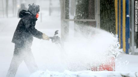
The heavy precipitation mixture threatens power outages, tree damage, and dangerous travel conditions, the forecasters said. Areas seeing those conditions can also expect to experience below freezing temperatures in the days after the wintry mix ends.

Dangerous travel conditions were already seen Tuesday in Illinois, where officials closed parts of several highways after crashes led to some injuries.

“The combination of the volumes of snow, high winds, and frigid temperatures make travel near impossible in some areas of the state with several highways shutdown from vehicle crashes and jack-knifed semi-trucks,” Kevin Sur, spokesperson for the Illinois Emergency Management Agency, told CNN.

Amtrak canceled multiple train routes Wednesday and Thursday in and out of Chicago, including the Cardinal Train 51 to New York. The route between St. Louis and Kansas City is also canceled, Amtrak said.
The powerful storm is also curtailing air travel Thursday, which is projected to be one of the 10 worst days for air travel over the past year, with more than 40% of flights already canceled as of Wednesday afternoon at more than a dozen major US airports from Texas to Ohio, according to data from FlightAware.
In Texas, the storm will test the state’s power grid, which suffered lengthy and widespread outages last February when a snow and ice storm left thousands without power for weeks and 246 people died, including many from hypothermia.

Leaders of the state’s power grid — Electric Reliability Council of Texas, or ERCOT — reassured Texans Wednesday that it expects to be prepared to handle the high demand the storm will deliver but also warned there may be local outages unrelated to capacity.

“With frozen precipitation there is always a chance for local outages caused by things like ice on wires or fallen tree limbs. These local outages are not related to the amount of available electricity generated and put on the grid,” interim CEO Brad Jones said in a news release.
There were nearly 48,000 homes and businesses without power in Texas as of early Thursday morning, according to PowerOutage.us. More than 16,000 outages were reported in Oklahoma and nearly 12,000 in Arkansas.

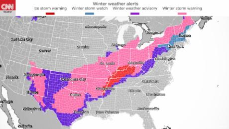
Here’s when and where to expect ‘several rounds of winter weather’

As the storm system pushes further east, forecasters say the storm will deliver a variety of winter weather hazards.

“The system will be prolonged with several rounds of winter weather lasting through Friday for portions of the central U.S. before shifting to the interior Northeast,” the NWS said Wednesday.

Here is forecast information from CNN meteorologists Robert Shackelford and Mike Saenz for some cities in the storm’s path:

  • Texas: Dallas may see up to a half inch of ice. Freezing rain and sleet are projected to peak around 7 a.m. Thursday. Snow will peak between 7 a.m. and 10 a.m. In Austin, ice will pile up to about a quarter of an inch and sleet may reach a half inch. Conditions could potentially peak through Thursday afternoon.
  • St. Louis: The city could see between 5 and 8 inches of additional snow Thursday after already getting about 4 inches in isolated areas. Peak conditions will last through 11 a.m. Thursday.
  • Memphis, Tennessee: An additional quarter inch to half inch of ice are expected Thursday, when conditions are expected to peak between 4 a.m. and 1 p.m. About one tenth of an inch of ice has already been reported.
  • Louisville, Kentucky: Up to half an inch of ice is expected to form. Plus, about 1 inch sleet and snow — each — is projected to fall. Peak hours for a mixture of freezing rain, snow and sleet are 7 a.m. Thursday through 1 a.m. Friday.
  • Little Rock, Arkansas: The city could get up to a half inch of ice in addition to an inch each of snow and sleet. Peak hours are expected between 3 a.m. and 11 a.m.
  • Oklahoma City: A record daily maximum snowfall of 3 feet was already measured and another four inches of snow is possible. The area could also reach half an inch of ice.
  • Chicago: The Windy City could see up to 4 inches of additional snow pile on top of the nearly 9 inches that already fell.
  • Cincinnati: This part of Ohio may see up to 0.3 inch of ice. Snow and sleet are projected to fall between 3 and 6 inches. The peak is projected to be Thursday morning when freezing rain will change to snow by afternoon.
  • Indiana: After getting slammed with more than 11 inches of snow, South Bend could see an additional 2 to 6 inches. Peak conditions will persist though 6 p.m. Thursday. In Indianapolis, where up to 3 more inches of snow could fall, peak conditions will also last through 6 p.m. About 4 inches have already fallen, with some areas seeing as many as 8 inches.
  • Buffalo, New York: This upstate region could see between 7 and 13 inches of snow, which is expected to peak Thursday afternoon through evening.

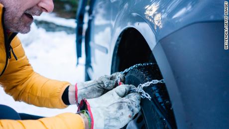
How officials are preparing

In anticipation of those potentially dangerous conditions, some schools have canceled classes this week.

The Dallas Independent School District will close Thursday and Friday, and schools are not expected to make up those days, officials said.

School districts in Kansas City, Missouri, and Santa Fe, New Mexico, also shuttered classrooms Wednesday due to the storm.

Meanwhile, state leaders are taking steps to prepare.

The governors of Illinois and Arkansas deployed their states’ National Guard while Missouri and Oklahoma are under states of emergency through Thursday.

Arkansas allocated $250,000 for recovery efforts. And Illinois prepared more than 1,800 trucks and equipment to plow, treat roads and respond to weather emergencies, according to the state’s Department of Transportation.

CNN’s Joe Sutton, Amanda Musa, Jenn Selva, Pete Muntean, Greg Wallace, Rosa Flores, and Michelle Watson contributed to this report.

Read original article here

‘Sleet-Fest’ Forecast For Friday Leading Into A Weekend Freeze – CBS Boston

BOSTON (CBS) – Just days after our biggest snowstorm in years, there is no rest for the weather weary. As Bill Belichick would say, “we’re on to Friday.” This storm will be very different than last Saturday’s blizzard. In fact I’m not even sure we can call it a storm. It is more like a frontal passage or a weather boundary. (Try describing that to news producers looking for a headline!). There will be no wind issues. There will be no coastal flooding, no splashover, no waves battering the houses in Scituate. In fact, there really won’t even be that much snow in southern New England!

So what’s the big deal?

Well, despite the mild weather Wednesday and Thursday, we will still have a decent snowpack when the precipitation arrives Thursday, somewhere between 6 and 12 inches in most areas. This “system” will be loaded with moisture. Total liquid amount (rain, ice and snow) will be close to 2”, that’s a lot of “stuff” falling from the sky. And then to top it off, it’s going to be cold all weekend. The entire region plunges into the teens Friday night and we won’t get out of the 20s Saturday. So, any standing water will freeze up and we are left with an ice-encrusted mess.

Let’s back up a bit and take this piece by piece.

TIMELINE:

Rain arrives during the day Thursday, becoming steadier and heavier by the afternoon and evening. The snow and ice are confined to central and northern New England.

Thursday night the cold air starts to push southward. By midnight we see a change to sleet in parts of southern New Hampshire. By dawn Friday, the sleet has worked all the way down through northern Mass., perhaps nearing Boston and the Mass Pike.

During the day Friday, it’s a sleet-fest for most of southern New England. Rain will hold on over the South Coast, Cape and Islands until the very end of the storm Friday evening. There will be some pure snow on the northern fringes of the precipitation shield. The sleet should change to snow as far south as about Boston before everything begins to taper off late Friday afternoon/evening.

SLEET vs FREEZING RAIN:

Some brief thoughts on the impacts of sleet vs freezing rain. We believe that for the vast majority of southern New England sleet will be the main precipitation type (once the rain changes over) and not freezing rain.

Freezing rain occurs when you have mild air (above 32 degrees) above the ground but a shallow layer of below freezing air right at the surface. So as the rain falls, it hits the cold ground (streets, sidewalks, patio, driveway, trees) and instantly freezes. This is the most treacherous and dangerous precipitation type and, in larger amounts, can cause massive damage to trees and power lines. All of our infamous ice storms, when you may have lost power for days, are due to freezing rain.

(WBZ-TV graphic)

Sleet occurs when you get a larger layer of cold air. The rain falls from above into a thick layer of atmosphere that is below freezing. Therefore, it has time to ice up into tiny pellets. These hit the ground and tend to bounce off of everything and have that pinging sound. Sleet, in large amounts, can accumulate but much less readily than snow. Most importantly, it does not accrete on trees and wires so the power outage risk is minimal.

ACCUMULATIONS:

Given that we are forecasting a rain-to-sleet situation for most of southern New England, the accumulations will be low.

There could be as much as 1-to-3 inches of sleet and snow in northern Massachusetts (north of Pike, mainly in northern Worcester and northern Middlesex counties).

Over the Mass. and New Hampshire border 3-to-6” of snow and sleet are possible up through Manchester, Concord and Lake Winnipesaukee.

(WBZ-TV graphic)

Great news for skiers. The snow jackpot will be in the mountains, particularly the northern Greens and the Whites. We expect 6-12” in those areas with perhaps as much as 18” in some of the higher, northernmost peaks.

THE FREEZE:

Temperatures will be dropping all day on Friday. By late afternoon all of southern New England is below 32 degrees and everything that has fallen, any standing water, will ice up. Any untreated surfaces and roadways will become very slippery. We stay below freezing all weekend long. Thankfully, we will see a good deal of sunshine Saturday and Sunday, so despite the cold temperatures, some melting is still likely to occur.

(WBZ-TV Graphic)

Timing is critical and we will keep you updated as new data comes in. Stay with WBZ-TV, CBSBoston.com and CBS News Boston.

Read original article here

NC weather forecast: Ice, sleet, freezing rain more likely Sunday than snow in North Carolina

RALEIGH, N.C. (WTVD) — The system threatening to bring winter weather to central North Carolina this weekend continues to slow down.

As of Thursday morning the system remained off the Oregon coast. It is expected to move ashore sometime Thursday.

As it moves ashore, it will make forecasting its impacts in North Carolina more reliable. Keep a close eye on the forecast from your First Alert Weather Team over the next 24-48 hours for the most accurate and up-to-date details about what this storm will bring to your neighborhood.

Right now, the system looks like it will bring more of a wintry mix than snow.

Sleet, freezing rain and ice combined with strong winds are shaping up to be the biggest threats–which means slick roads, falling trees, and power outages could be the main dangers you need to watch out for.

WATCH: First Alert to Winter Weather

TIMING

High temperatures Saturday will be in the upper 30s, but they will dip into the mid to upper 20s Saturday night into Sunday morning.

The low pressure system that will bring moisture into the ABC11 viewing area is expected to arrive around daybreak Sunday.

A wintry mix with sleet and freezing rain will likely begin in the Sandhills and move its way north and east across central North Carolina.

By midday and early afternoon, all of central North Carolina will be seeing some sort of precipitation. With areas north and west more likely to be seeing snow, a wintry mix likely in and around the Triangle and mostly rain in areas more to the south and east.

According to the Weather Prediction Center’s probabilistic forecast, there is there is a 30-50 percent chance snow/sleet will exceed 0.25″ liquid equivalent Sunday morning to early Monday morning. However, just west into the Triad, that chance rises to 50-70 percent.

Warmer air will push in Sunday evening, causing much of the snow and wintry mix to transition into rain. This is when flooding could become a problem.

Specifics of this forecast could change significantly in the next 24-48 hours. Keep checking back for updates, but in the meantime go ahead and start making a plan for how you’re going to prepare for this event.

Copyright © 2022 WTVD-TV. All Rights Reserved.


Read original article here

NC weather forecast: Ice, sleet, freezing rain more likely Sunday than snow in North Carolina

RALEIGH, N.C. (WTVD) — The system threatening to bring winter weather to central North Carolina this weekend continues to slow down.

As of Thursday morning the system remained off the Oregon coast. It is expected to move ashore sometime Thursday.

As it moves ashore, it will make forecasting its impacts in North Carolina more reliable. Keep a close eye on the forecast from your First Alert Weather Team over the next 24-48 hours for the most accurate and up-to-date details about what this storm will bring to your neighborhood.

Right now, the system looks like it will bring more of a wintry mix than snow.

Sleet, freezing rain and ice combined with strong winds are shaping up to be the biggest threats–which means slick roads and falling trees could be the main dangers you need to watch out for.

WATCH: First Alert to Winter Weather

TIMING

High temperatures Saturday will be in the upper 30s, but they will dip to around freezing Saturday night into Sunday morning.

The low pressure system that will bring moisture into the ABC11 viewing area is expected to arrive around daybreak Sunday.

A wintry mix with sleet and freezing rain will likely begin in the Sandhills and move its way north and east across central North Carolina.

By midday and early afternoon, all of central North Carolina will be seeing some sort of precipitation. With areas north and west more likely to be seeing snow, a wintry mix likely in and around the Triangle and mostly rain in areas more to the south and east.

Warmer air will push in Sunday evening, causing much of the snow and wintry mix to transition into rain.

Specifics of this forecast could change significantly in the next 24-48 hours. Keep checking back for updates, but in the meantime go ahead and start making a plan for how you’re going to prepare for this event.

Copyright © 2022 WTVD-TV. All Rights Reserved.


Read original article here

City Sleet 5 Pocket Pants are only $109

Eat This, Not That!

15 Supplements Every Man Needs, Say Doctors

In an ideal world, you’d get all of your essential vitamins and minerals from the food you eat. But looking at the average American diet, one thing is clear: It’s time to call for some backup. According to a meta-analysis of studies done by Oregon State University, 75 percent of us aren’t eating the daily recommended amount of fruit, and 80 percent aren’t eating enough vegetables. That means 94 percent of us don’t meet the daily recommended intake of Vitamin D, half of us don’t get enough magnesium (read on to find out why that mineral is crucial), and 44 percent aren’t getting enough calcium.That can have serious health consequences down the road, as our bodies cope with aging. We asked experts what supplements can help fill in the gaps. Read on, and to ensure your health and the health of others, don’t miss these Signs Your Illness is Actually Coronavirus in Disguise. 1 A Multivitamin “This is the best way to assure that you are getting the majority of the micronutrients and minerals you need in just one pill,” says Yeral Patel, MD, a board-certified physician in anti-aging regenerative and family medicine in Newport Beach, California. “Today’s diets, with their various restrictions and exclusions, don’t allow us to get all the minerals and nutrients we need solely from the foods we eat.”The Rx: “I recommend buying from a source that sells medical-grade products to assure that they are pure, safe, and do not contain any fillers,” says Patel, who likes the brands Designs for Health, Metagenics, Integrative Therapeutics and Thorne. 2 Vitamin D Most of us are deficient in the “sunshine vitamin,” so named because our bodies produce it naturally when skin is exposed to the sun. It is believed to guard against several types of cancer and is essential for strong bones, a particular concern as we age.”Bone health is important for both women and men, although we tend to hear more about it as a woman’s issue,” says Nicole Avena, Ph.D., assistant professor of neuroscience at Mount Sinai School of Medicine and visiting professor of health psychology at Princeton University. “The reality is that men are also at risk for developing bone-related conditions, including osteoporosis. Vitamin D is important because it helps maintain bone health in a number of ways. For one, it improves your body’s absorption of calcium.”The Rx: The RDA (recommended daily allowance) for Vitamin D is 600 IU for adults up to age 70 and 800 IU for adults 71 or older. Some experts consider that low for adults of any age, suggesting it should be raised to at least 1,000 IU per day. According to the National Institutes of Health (NIH), the upper limit for Vitamin D is 4,000 IU daily. 3 Vitamin B12 The B vitamins are crucial to the production of energy, and Vitamin B12 is particularly important for brain function. “If you don’t get enough B12, you can experience brain fog or lethargy,” says Avena. “As we age, we may need to take vitamin B12 supplements to get the recommended amount. We often have more difficulty absorbing B12 that we get from food.”The Rx: “Frunutta makes a sublingual vitamin B12 that is easy to ingest and dissolves right under the tongue, which helps bypass the absorption issue,” says Avena. The RDA of Vitamin B12 is 2.4mcg. According to the NIH, an upper limit has not been set because Vitamin B12 has not been shown to cause harm. 4 Fiber “Getting enough fiber is important for everyone, however, men need to get the most fiber,” says Amanda Kostro Miller, RD, LDN, a registered dietitian and advisor to Smart Healthy Living. “Fiber helps to keep things moving, can help you lower cholesterol, and may also help you control your blood sugar if you have diabetes.”The Rx: Men should aim for 38 grams of fiber per day overall, says Miller. If you’re not getting that much from food, you might want to look into a supplement. 5 Magnesium “If there is one mineral almost everyone needs, it is magnesium,” says Heidi Moretti, MS, RD, a registered dietitian in Missoula, Montana, who has worked in hospitals for two decades. “Some research suggests that 70 percent of Americans fall short. This may lead to digestive issues, poor sleep, mood swings, and increased risk of heart disease.”Magnesium is especially important to men because it aids the production of testosterone, which declines with age. “Most men begin to experience a decrease in testosterone around age 30,” says Anthony Kouri, MD, an orthopedic surgeon at the University of Toledo Medical Center. “With loss of testosterone comes decreased stamina, loss of muscle mass and lower energy levels. Research has shown that magnesium supplementation increases testosterone levels and lowers men’s risk of developing cardiovascular disease.”The Rx: The recommended daily allowance for magnesium actually increases slightly for adults over 30, to 420mg per day for men and 320mg for women. The NIH says the upper tolerable limit of magnesium is 350mg daily (that applies only to a magnesium supplement). 6 Calcium Bone health becomes a priority after age 40, when bone density starts to decline. A calcium supplement can help. “Calcium serves many purposes in the body, but is essential for strong bones,” says Kouri. Getting adequate Vitamin D along with calcium is important, because D enables calcium absorption.The Rx: The recommended daily amount of calcium is 1,000 mg for adults up to age 50. That increases to 1,200 mg for adult women between age 51 and 70, and both sexes after age 71. The upper daily limit for adults 50 and younger is 2,500 mg; for adults over 51, it’s 2,000 mg. 7 CoQ10 CoQ10 (Conenzyme Q10) is a powerful antioxidant generated by the body to keep cells healthy and functioning properly. Levels decline as we age, and CoQ10 deficiency has been associated with a number of diseases. A 2018 meta-analysis of studies found that taking CoQ10 may improve heart function and improve symptoms of neurodegenerative diseases.The Rx: There is no established daily dose of CoQ10. 8 Fish Oil (Omega-3 fatty acids) Omega-3s fatty acids are great for our heart and may reduce inflammation throughout the body. “Omega-3 fatty acids can cause a major reduction in triglycerides, blood pressure, blood clots, plaque formation, and inflammation, which are all heart disease risk factors,” says Kouri. “People who are depressed and anxious are likely to see improvement if they begin taking omega-3 supplements. In addition, omega-3s helps prevent macular degeneration, which can cause vision impairment and blindness.”The Rx: The National Institutes of Health recommend women get 1,100mg and men have 1,600mg of omega-3s daily. 9 Probiotics “Probiotics are beneficial to both men and women of all ages for maintaining a healthy microbiome and immune function,” says Lawrence Hoberman, MD, a board-certified gastroenterologist in San Antonio, Texas. “As men age, they require more urinary tract and prostate support. Probiotics have been shown to reduce the risk of chronic prostatitis as well as treat benign prostatic hyperplasia, or enlarged prostate, and accompanying urinary tract problems.”The Rx: Choose a brand of probiotic with varying strains to start. Specific strains may be helpful to certain conditions, notes Hoberman. “Lactobacillus acidophilus combats harmful, disease-causing bacteria while acting as a natural antibiotic,” he says. “Lactobacillus and Bifidobacterium are also beneficial to prostate health, improving immune function and reducing inflammation that could lessen the risk of developing prostate cancer.” 10 Zinc According to the National Institutes of Health, zinc helps the body’s immune system fight off bacteria and viruses. Even more crucially to many guys, it’s essential for the male sex organs because it aids in the production of testosterone and prolactin. Zinc deficiency has been linked to erectile dysfunction.The Rx: Adult men are advised to get 11mg a day. The NIH says the upper tolerable limit is 40 mg daily, although that doesn’t apply to men who are taking zinc under a doctor’s care. 11 Iodine “This little-known nutrient plays a big role in your thyroid health,” says Moretti. “Your thyroid is your central regulator of metabolism. Without enough iodine, it won’t work well. Why are men low in iodine? Too many processed foods.”The Rx: The RDA for iodine is 150 mcg, and the upper limit is 1,100 mcg. “Although you need enough iodine, don’t take large doses without the supervision of your doctor,” says Moretti. Too much can send your thyroid into overdrive. 12 Plant Protein Adequate protein intake is essential for maintaining lean muscle, which keeps the metabolism humming as we age. If you’re not getting enough, you may want to look into supplementing with plant protein, which tends to be easier to digest than formulations containing whey.The Rx: The current RDA for protein is 0.8 grams per kilogram of body weight for adults over 18—about 66 grams for a 180-pound person. But some studies suggest that adults over 65 may need more. Talk to your doctor about what’s right for you. 13 Vitamin C It’s not the miracle cure-all it was touted as for much of the twentieth century, but Vitamin C is essential for immune system support and collagen production.The Rx: The recommended daily allowance of Vitamin C is 90 mg for adult men, while the upper limit is 2,000 mg. 14 Vitamin B1 If you’re a tippler, you might be deficient in this B vitamin, also known as thiamin. “This is an essential B vitamin in which we often become depleted,” says Arielle Levitan, MD, an internal medicine physician in Chicago and co-founder of Vous Vitamin. Thiamin is key to optimal functioning of the brain and nerves. Additionally, “Alcohol competes with thiamin, and replacing it helps in the prevention of toxic effects.”The Rx: The RDA of thiamin is 1.2 mg. According to the NIH, an upper limit has not been set. 15 Collagen “Over time, our bodies’ natural ability to produce collagen wears down, so it’s a good idea to consider a supplement,” says Avena. “Collagen supplements can bring relief from pain by combating aging tissue and arthritis, aiding normal repair of ligaments, tendons, joints and bones while improving connective tissue. It can also help improve skin elasticity, which can delay the appearance of wrinkles.”The Rx: You can add collagen supplements to a daily smoothie or mix them with water. “Further Food makes a flavorless collagen supplement powder, as well as a chocolate one,” says Avena. These essential vitamins and minerals will keep your health in check. And to get through this pandemic at your healthiest, don’t miss these 35 Places You’re Most Likely to Catch COVID.

Read original article here

N.J. weather: Winter storm watch issued in 17 counties. Up to 8 inches of snow and sleet could fall in Thursday storm.

The National Weather Service has issued a winter storm watch for 17 New Jersey counties ahead of a storm that is expected to dump 4 to 8 inches of snow and sleet across our region Thursday and early Friday, along with a thick layer of ice in some areas.

The winter storm watch covers all of northern New Jersey, most of central New Jersey and the western region of South Jersey. It is effective from early Thursday morning through Friday afternoon, with the exact times varying from region to region.

ALSO: When will the snow start? Latest update on timing, track for ‘slop-fest’ winter storm

Although a watch is not as urgent as a warning, it puts residents and public officials on alert that there’s a potential for dangerous winter weather on the way. If forecasters remain confident the storm will drop heavy snow, heavy sleet or significant freezing rain, the watch will likely be upgraded to a warning before the storm — the latest in our long parade of February storms — arrives.

The National Weather Service is predicting 6 to 8 inches of snow for parts of New Jersey and at least a few inches for the entire state on Thursday. Here’s the latest forecast on the timing and precipitation types.

The storm could be a “slop-fest,” said forecaster Nick Carr. “What we might see is a few inches of snow on the front end and then an inch or two of sleet.”

Active storm alerts

Here’s a look at the winter storm alerts in each county as of late Tuesday afternoon:

Bergen County: Winter storm watch effective from 6 a.m. Thursday through 6 a.m. Friday. Forecasters are expecting 4 to 8 inches of snow in this area.

Burlington County: Winter storm watch effective from 4 a.m. Thursday through 1 p.m. Friday. Forecasters are expecting 3 to 6 inches of snow and sleet in the northwestern region of the county, plus a coating of ice ranging from one-tenth of an inch to as much as a quarter-inch.

Camden County: Winter storm watch effective from 4 a.m. Thursday through 1 p.m. Friday. Forecasters are expecting 3 to 6 inches of snow and sleet in this area, plus a coating of ice ranging from one-tenth of an inch to as much as a quarter-inch.

Essex County: Winter storm watch effective from 6 a.m. Thursday through 6 a.m. Friday. Forecasters are expecting 4 to 8 inches of snow in this area.

Gloucester County: Winter storm watch effective from 4 a.m. Thursday through 1 p.m. Friday. Forecasters are expecting 3 to 6 inches of snow and sleet in this area, plus a coating of ice ranging from one-tenth of an inch to as much as a quarter-inch.

Hudson County: Winter storm watch effective from 6 a.m. Thursday through 6 a.m. Friday. Forecasters are expecting 4 to 8 inches of snow in this area.

Hunterdon County: Winter storm watch effective from 4 a.m. Thursday through 1 p.m. Friday. Forecasters are expecting 5 to 8 inches of snow and sleet in the northwestern region of the county.

Mercer County: Winter storm watch effective from 4 a.m. Thursday through 1 p.m. Friday. Forecasters are expecting 3 to 6 inches of snow and sleet in this area, plus a coating of ice ranging from one-tenth of an inch to as much as a quarter-inch.

Middlesex County: Winter storm watch effective from 4 a.m. Thursday through 1 p.m. Friday. Forecasters are expecting 3 to 6 inches of snow and sleet in this area, plus a coating of ice ranging from one-tenth of an inch to as much as a quarter-inch.

Monmouth County: Winter storm watch effective from 4 a.m. Thursday through 1 p.m. Friday. Forecasters are expecting 3 to 6 inches of snow and sleet in the western region of the county, plus a coating of ice ranging from one-tenth of an inch to as much as a quarter-inch.

Morris County: Winter storm watch effective from 4 a.m. Thursday through 1 p.m. Friday. Forecasters are expecting 5 to 8 inches of snow and sleet in the northwestern region of the county.

Passaic County: Winter storm watch effective from 6 a.m. Thursday through 6 a.m. Friday. Forecasters are expecting 4 to 8 inches of snow in this area.

Salem County: Winter storm watch effective from 4 a.m. Thursday through 1 p.m. Friday. Forecasters are expecting 3 to 6 inches of snow in this area, plus a coating of ice ranging from one-tenth of an inch to as much as a quarter-inch.

Somerset County: Winter storm watch effective from 4 a.m. Thursday through 1 p.m. Friday. Forecasters are expecting 5 to 8 inches of snow and sleet in the northwestern region of the county.

Sussex County: Winter storm watch effective from 4 a.m. Thursday through 1 p.m. Friday. Forecasters are expecting 5 to 8 inches of snow and sleet in the northwestern region of the county.

Union County: Winter storm watch effective from 6 a.m. Thursday through 6 a.m. Friday. Forecasters are expecting 4 to 8 inches of snow in this area.

Warren County: Winter storm watch effective from 4 a.m. Thursday through 1 p.m. Friday. Forecasters are expecting 5 to 8 inches of snow and sleet in the northwestern region of the county.

Snow forecast maps

This is the National Weather Service’s early snow forecast for most of New Jersey, eastern Pennsylvania, Delaware and eastern Maryland for Thursday’s winter storm.National Weather Service

This is the National Weather Service’s early snow forecast for northeastern New Jersey, New York City, Long Island and the Hudson Valley for Thursday’s winter storm.National Weather Service

Ice forecast

This is the National Weather Service’s early ice accumulation forecast for parts of New Jersey, eastern Pennsylvania, Delaware and eastern Maryland for Thursday’s winter storm.National Weather Service

Thank you for relying on us to provide the journalism you can trust. Please consider supporting NJ.com with a subscription.

Len Melisurgo may be reached at LMelisurgo@njadvancemedia.com.

Read original article here

Winter Storm Warning issued; potential for 6 or more inches of snow

Watch the latest forecast in the player above.The first wave of snow and winter weather in the WLKY viewing area is lingering, but a more impactful round two bringing big accumulation will move in this afternoon.A winter storm warning remains in effect through 1 p.m. on Tuesday afternoon.This storm has the potential to be one of our biggest winter storms in several years. Interactive radar | Closings, delays Many areas saw about an inch or so of snow Monday morning. Some flurries will linger on for another coating. The second big batch of wintry precipitation comes later Monday afternoon. TIMELINE: WLKY’s Matt Milosevich recommends wrapping up plans by 2 or 3 p.m.By Tuesday morning, snow totals of 6 or more inches will be common. Some places in the northwest of our area have the chance to hit as much as 12 inches. The projection for Louisville is 6 to 8 inches.The areas in the southeast part of the viewing area could see more sleet than snow, so their snow totals could be much lower, more like 1 to 4 inches. The storm will wrap up by the end of Monday into early Tuesday — drier skies return Tuesday afternoonAs for temperatures, it feels like its in the single digits Monday morning and the cold will keep that snow and ice around for awhile.Officials have been advising people to stay off the roads in the next couple of days.Wednesday night into Thursday could bring yet another winter storm. Temperatures finally get above freezing on Sunday.Stay up to date on this forecast right here.

Watch the latest forecast in the player above.

The first wave of snow and winter weather in the WLKY viewing area is lingering, but a more impactful round two bringing big accumulation will move in this afternoon.

A winter storm warning remains in effect through 1 p.m. on Tuesday afternoon.

This storm has the potential to be one of our biggest winter storms in several years.

Interactive radar | Closings, delays

Many areas saw about an inch or so of snow Monday morning. Some flurries will linger on for another coating. The second big batch of wintry precipitation comes later Monday afternoon.

TIMELINE:

Hearst Owned

Monday snow timelines

WLKY’s Matt Milosevich recommends wrapping up plans by 2 or 3 p.m.

By Tuesday morning, snow totals of 6 or more inches will be common. Some places in the northwest of our area have the chance to hit as much as 12 inches. The projection for Louisville is 6 to 8 inches.

The areas in the southeast part of the viewing area could see more sleet than snow, so their snow totals could be much lower, more like 1 to 4 inches.

The storm will wrap up by the end of Monday into early Tuesday — drier skies return Tuesday afternoon

As for temperatures, it feels like its in the single digits Monday morning and the cold will keep that snow and ice around for awhile.

Officials have been advising people to stay off the roads in the next couple of days.

Wednesday night into Thursday could bring yet another winter storm. Temperatures finally get above freezing on Sunday.

Stay up to date on this forecast right here.

Read original article here

Patchy Freezing Drizzle Possible Overnight; Dry & Cloudy Valentine’s Day

TEAM FORECAST WITH METEOROLOGIST ETHAN HUSTON ETHAN: COULD SEE SOME FREEZING DRIVEL — DRIZZLE OVERNIGHT. AND THEN WE ARE TRACKING A PAIR OF STRONGER STORMS THAT WILL MOVE THROUGH THE VALLEY NEXT WE WE HAVE A WINTER WEATHER UNTIL TOMORROW MORNING AND IT IS FOR THE THREATS OF SOME PATCHY DRIZZLE. WITH TEMPERATURES BELOW FREEZING, IF WE SEE PRINT — SEE PRECIPITATION, IT CAN BRING SOME ICE ON BRIDGES AND OVERPASSES. MOST OF THE VALLEY WILL STAY DRY TONIGHT. YOU CAN SEE THE RADAR PICKING UP ON SOME RETURNS OF SNOWFLAKES. YOU CAN SEE SOME FREEZING DRIZZLE BACK TOWARDS BLOOMINGTON. IN PARTS OF YORK AND LANCASTER, IT WILL HAVE THE BEST OPPORTUNITY FOR SOME DRIZZLE. ALSO IF YOU’RE HEADING DOWN TOWARDS BALTIMORE, THERE WILL HAVE AMOUNTS THERE. THE BULK OF THE STORM IS MOVING OUT AND WILL SHUT DOWN MOST TONIGHT. WE WILL KEEP THE THREAT FOR PATCHY FREEZING DRIZZL MOST TEMPERATURES HOVERING. WE WILL KEEP THE CLOUDS AROUND. TEMPERATURES WILL START RISING ABOVE FREEZING. WE WILL TOP OFF IN THE MID TO UPPER 30’S. WE WILL KEEP THE CLOUDS AROUND OF THE DAY. PRECIPITATION CHANCES ARE HIGHEST AT MIDNIGHT AND THEN TAPER OFF. WE MADE IT TO 34 OUR HIGH TODAY. OUR CURRENT LOW TEMPERATURE IS 27, THAT IS WHERE WE ARE IN LANCASTER. IT IS BRUTALLY COLD ACROSS THE HIGH PLAINS. -21 IN NORTH DAKOTA. TOWARD THE CANADIAN BORDER, -30. WITH THE WIND IT FEELS LIKE -59. DANGEROUSLY COLD. ONLY 19 IN MEMPHIS, TENNESSEE. MASSIVE RIDGE OF HIGH TEMPERATURE THAT HAS PUSHED THE JET STREAM DOWN INTO THE GULFSTREAM. IT IS BRINGING UP THE MOISTURE FROM FLORIDA ACROSS THE CAROLINAS INTO T VALLEY. I DO EXPECT THE ORIENTATION OF THE STREAM TO REMAIN LIKE THIS. THAT MEANS WE HAVE A PARADE OF STORMS. ANOTHER STORM IS ON ITS WAY. IT WILL BE HERE ON MONDAY, TUESDAY. ANOTHER POWERFUL STORM IS ON THE OPEN WATERS. IT IS DUE IN ON THURSDAY OR FRIDAY. WITH THE JET STREAM, ARMOR AIR WI BE INGESTED INTO THE STORM AND WE WILL SEE MORE OF A WINTRY MIX THEN SNOW. NOTICE THINGS QUIET DOWN AS WE HEAD INTO EARLY TOMORROW MORNING. FOR VALENTINE’S DAY, IT WILL BE FAIRLY CLOUDY. THERE MAY BE PEEKS OF SUNSHINE BUT MONTHS — MOST OF THE DATE WILL BE CLOUDY. IT IS LATER IN THE DAY WHE WE WILL HAVE HIGHER CHANCES OF PRECIPITATION, MOST LIKELY SNOW AT THIS TIME NORTH AND NORTHWEST OF I-81. SOUTH AND SOUTHEAST OF THE I-81 COULD SEE A WINTRY MIX. MOST IN FREEZING RAIN. THE LAWN — LONG-RANGE PREDICTOR, I EXPECTED MONDAY AND POSSIBLY INTO TUESDA THE NEXT-DOOR MOVES UP FROM THE SOUTHWEST, IT STARTS OFF AS SNOW BUT COULD SWITCH OVER TO PERIODS OF SLEET AND RAIN. THERE MAY BE TIME BEFORE THAT STORM PULLS AWAY. MIDDAY MONDA TO MONDAY NIGHT, THE MIX DEVELOPS AND BECOMES WIDESPREAD AND HAS A HIGHER POTENTIAL FOR ICE. IT COULD BE IN CASH — AN ICE STORM. THE NEXT ONE GETS HE ON THURSDAY. IT COULD BE A WINTRY MIX. THE WORST LOOKS TO BE THURSDAY MIDDAY INTO THURSDAY NIGHT. DETAIL STILL NEED TO BE FINE-TUNED AS WE GET CLOSER TO EACH STORM. WE WILL OFFER YOU MORE DETAIL STAY TUNED. HERE IS THE 10 DAY FORECAST. EARLY IMPACT TOMORROW MORNING, THE MAJORITY OF VALENTINE’S DAY WILL BE DRY. MONDAY WILL BE IMPACT DAY BECAUSE THE MIX WILL MOVE IN AND CONTINUE MONDAY NIGHT INTO TUESDAY. WE WILL WATCH ANOTHER STORM THURSDAY INTO FRIDAY. WEATHER DRIES OUT AS WE HEAD INTO THE WEEKEND AND TE

Patchy Freezing Drizzle Possible Overnight; Dry & Cloudy Valentine’s Day

A fast-moving storm off the East Coast along with the jet stream over the region will keep the chances high for some light, spotty, freezing rain, freezing drizzle, snow or sleet around the valley Saturday evening.With a chance for light freezing rain and freezing drizzle continuing overnight, the National Weather Service has issued a Winter Weather Advisory for much of the Susquehanna Valley through 8 a.m. but only through 4 a.m. for Adams, Lancaster and York counties. The freezing temperatures and scattered wintry mix could lead to a glaze of ice on untreated roadways, bridges, and overpasses. Use caution if you’re traveling tonight. Temperatures hover in the mid 20s then rise to near 30 by dawn Sunday.SundayChances for scattered freezing rain, drizzle taper early Sunday morning. There could be some mist or fog lingering into the early afternoon as temperatures rise. Highs Sunday will be milder than Saturday, but still cool for the season, in the mid 30s. Skies are expected to stay cloudy all day.MondayA more substantial winter storm arrives Monday. There could be some light snow or freezing rain showers early Monday morning. Widespread precipitation is likely by midday Monday. Confidence is growing that a wintry mix with icing potential is possible Monday evening into Monday night, especially for areas northwest of I-81. The mix continues Monday night into Tuesday, before tapering midday. Highest impacts from this storm will be Monday evening commute through Tuesday midday. Looking aheadWednesday looks dry, fairly cloudy with highs in the lower 30s.Another storm approaches Thursday. The current track of this storm indicates snow as the most likely form of precipitation at the start, but then warmer air near the cloud level starts to move into the storm and a wintry mix, including freezing rain, is possible. It’s possible this storm lingers into Friday with temperatures turning milder.Next weekend looks dry with Saturday’s highs staying chilly in the mid 30s and Sunday warming to near average with highs in the lower 40s.You can find more forecasts on the WGAL Weather page on our website, downloading our app and sign-up for our newsletter.

A fast-moving storm off the East Coast along with the jet stream over the region will keep the chances high for some light, spotty, freezing rain, freezing drizzle, snow or sleet around the valley Saturday evening.

Hearst Owned

12 hour forecast.

With a chance for light freezing rain and freezing drizzle continuing overnight, the National Weather Service has issued a Winter Weather Advisory for much of the Susquehanna Valley through 8 a.m. but only through 4 a.m. for Adams, Lancaster and York counties.

Hearst Owned

Weekend storm of a wintry mix, puts much of the Susquehanna Valley under a winter weather advisory issued by the National Weather Service.

The freezing temperatures and scattered wintry mix could lead to a glaze of ice on untreated roadways, bridges, and overpasses. Use caution if you’re traveling tonight. Temperatures hover in the mid 20s then rise to near 30 by dawn Sunday.

Hearst Owned

Map showing amounts of freezing rain predicted across the Susquehanna Valley by 8 a.m. Sunday. 

Hearst Owned

Precipitation chances in the valley. 

Sunday

Chances for scattered freezing rain, drizzle taper early Sunday morning. There could be some mist or fog lingering into the early afternoon as temperatures rise. Highs Sunday will be milder than Saturday, but still cool for the season, in the mid 30s. Skies are expected to stay cloudy all day.

Hearst Owned

Rundown of winter weather heading our way.

Monday

A more substantial winter storm arrives Monday. There could be some light snow or freezing rain showers early Monday morning. Widespread precipitation is likely by midday Monday. Confidence is growing that a wintry mix with icing potential is possible Monday evening into Monday night, especially for areas northwest of I-81. The mix continues Monday night into Tuesday, before tapering midday. Highest impacts from this storm will be Monday evening commute through Tuesday midday.

Hearst Owned

Lon-range predictor for Monday. 

Looking ahead

Wednesday looks dry, fairly cloudy with highs in the lower 30s.

Another storm approaches Thursday. The current track of this storm indicates snow as the most likely form of precipitation at the start, but then warmer air near the cloud level starts to move into the storm and a wintry mix, including freezing rain, is possible.

Hearst Owned

Long-range predictor map. 

It’s possible this storm lingers into Friday with temperatures turning milder.

Hearst Owned

Tracking an active week ahead. 

Next weekend looks dry with Saturday’s highs staying chilly in the mid 30s and Sunday warming to near average with highs in the lower 40s.

You can find more forecasts on the WGAL Weather page on our website, downloading our app and sign-up for our newsletter.

Read original article here

Ice storm knocks out power, with sleet, freezing rain

CLOSE

The Fort Worth Fire Department said they were on scene of a 100-car pileup with “multiple people trapped.”

Storyful

NEW YORK – A winter storm dropped ice and snow along a 1,500-mile swath of land Thursday from central Texas through southern New Jersey, triggering widespread power outages and deadly pileups on treacherous highways. 

In Fort Worth, Texas, where roads were slick and icy, a 70-vehicle pileup led to five deaths and multiple injuries on I-35 Thursday morning, the Police Department said.

Farther south, in Austin, more than two dozen vehicles were involved in a pileup on an icy road, and one person was injured, emergency officials said. “This cannot be overstated today,” the National Weather Service in Austin tweeted Thursday morning. “PLEASE, DO NOT TRAVEL in the Hill Country and northern I-35 corridor. Conditions will continue to deteriorate as elevated roadways ice over first, followed by other roads.”

The storm that’s likely to affect millions moved into parts of Arkansas and Kentucky overnight and Thursday morning. It could bring up to half an inch of ice accumulation in some areas, the weather service said.

“A mixture of sleet and freezing rain is forecast to gradually come to an end today, but not before leaving a long swath of damaging ice accumulations,” the weather service said.

The Ozarks to the I-64 corridor in eastern Kentucky could see a quarter-inch of ice, according to the weather service.

“This amount of ice will likely lead to hazardous travel conditions, power outages and scattered tree damage,” the weather service said in a forecast.

In the Fort Worth crash, Mike Drivdahl, a public information officer for the Fire Department, told USA TODAY that first responders had to rescue multiple people from their vehicles using hydraulic tools. In addition to the fatalities, injuries ranged from minor to critical, and some people were transported to area hospitals. 

The incident occurred around a toll lane separated by a concrete barrier that created a “funnel type of effect,” Drivdahl said.

“I’m sure it’s going to come down to a chain reaction kind of event,” he said. Sand and ice melt were needed to make the roads safe for first responders trying to access the scene of the crash, he said. 

CLOSE

Arctic air brings very cold temperatures and the threat for snow and ice into the Ohio Valley and into the mid-Atlantic through late this week.

Accuweather

More than 57,000 customers in Kentucky and 43,000 in West Virginia were without power Thursday afternoon, according to tracking website PowerOutage.us.

Through Friday, the storm is forecast to bring light snow to the Ohio Valley and Central Appalachians to the Mid-Atlantic, which could see 2 to 6 inches, according to the weather service.

More freezing rain is possible Friday for the central Appalachians and parts of Virginia and northern North Carolina, the weather service said.

“Accidents and icy conditions could potentially shut down portions of highways for an extended period,” AccuWeather senior meteorologist Paul Walker said.

In Kentucky, the severe weather resulted in schools, COVID-19 vaccination sites and state offices closing. Louisville’s MetroSafe reported 10 crashes from 5 to 7 a.m. Thursday, including a wreck on I-64 that resulted in injuries. Wednesday saw 70 crashes from 1 to 10 p.m., including 17 with injuries.

Memphis woke up Thursday morning with a fresh blanket of ice slush on the roads and sagging tree limbs heavy with a sheath of frozen precipitation. Wednesday evening into Thursday morning, there was a rare appearance of “thunder ice,” or a thunderstorm with freezing rain or ice. 

Amid light snow Wednesday evening, an airplane with nearly 80 passengers slid off the runway at Pittsburgh International Airport, the Pittsburgh Post-Gazette reported. There were no injuries.

A light dusting of snow that fell overnight blanketed cars and sidewalks in New York City on Thursday morning.

The weather service said gusty winds could cause damage Thursday into Friday, and bitterly cold temperatures are expected into the weekend.

In Dallas, that cold air blast could lead to the Texas city’s first snowfall of the season Sunday, AccuWeather said.

“Anytime you get an Arctic air mass into Texas, you always have to worry about snow and ice because, at some point, warmer air is going to try to return. And when warmer air collides with that colder air, you get clouds and precipitation,” AccuWeather chief on-air meteorologist Bernie Rayno said.

The Pacific Northwest was also expected to see “impactful winter weather” through Saturday, the weather service said.

“A low-pressure system is forecast to enter southern Oregon this evening while simultaneously interacting with very cold air draining into the region. This combination may lead to not only heavy snow across the typical mountainous locations, but in the lowlands as well,” the forecast said.

Seattle and Portland could see some snow: AccuWeather predicted 1-3 inches in both cities.

Contributing: Billy Kobin, Louisville Courier-Journal; Micaela A. Watts, Memphis Commercial Appeal; The Associated Press

Autoplay

Show Thumbnails

Show Captions

Last SlideNext Slide

Read or Share this story: https://www.usatoday.com/story/news/nation/2021/02/11/winter-weather-ice-storm-knocks-out-power-sleet-freezing-rain/6717720002/


Read original article here

PennDOT LIFTS VEHICLE restrictions for south, central Pa.; speed limit restrictions remain

PennDOT lifts vehicle restrictions for south, central Pa., but speed limit restrictions still in place

WGAL News 8 snow coverage


VEHICLES LIKE TRAILERS, RVS, AND MOTORCYCLES. JERE NOW TO OUR TEAM OF REPORTERS, LET US GO TO MATT BARCARO WHO IS CHECKING OUT FRIGID — CONDITIONS IN DAUPHIN COUNTY. MATT: GOOD MORNING. WE ARE ALIVE AND ANNE WAS MENTIONING CARS SLIDING, AND WE ARE SEEING THAT IN THE INTERSECTIONS. DOWN THERE ON UNI DEPOSIT ROAD, THEY WERE CLEARING OUT THE INTERSECTIONS ON — TO SOME OF THE SIDE STREET SO YOU CAN SEE THAT THERE IS A BUILDUP AND WE ARE SEEING CARS GO FROM THE PLOWED ROAD TO THE SIDE RAIL — TO THE SIDE ROADS AND SLIDING. MOST OF THE RAIN WROTE — MAIN ROADS DO NOT HAVE SLUSH ON THEM, THEY ARE PLOWED TO THE PAVEMENT AND ARE WET. THEY HAVE BEEN ABLE TO TREAT AND PLOW ALL OF THE SECONDARY ROADS ON THEIR MENU. THE ONE THING THAT THEY ARE STILL ADJUSTING TO AND FOCUSING ON ARE THE PARTS OF THE COUNTIES THAT YOU TYPICALLY SEE DRIFTING SNOW BECAUSE OF THE WIND, NORTHERN DAUPHIN COUNTY, 209, AND THE SOUTHEAST PART OF DAUPHIN COUNTY, KEEP THAT IN MIND. THAT IS THE SITUATION AS TRAFFIC STARTS TO BUILD. LET US GO TO LANCASTER COUNTY WHERE LORI BURKHOLDER STANDING BY. LORI: GOOD MORNING. THE SNOW HAS PICKED UP AND SO HAS THE TRAFFIC IN LANCASTER COUNTY. WE ARE IN MANHEIM. BUT, LOOK AT WHAT WE ARE SAYING ON THE ROADS. THIS IS ROUTE 72, A PRETTY HEAVILY TRAVELED ROAD AND TRAFFIC IS PICKING UP. THERE IS STILL SOME SNOW ON THAT, AND THAT IS WHAT YOU WILL ENCOUNTER ON SOME OF THE HEAVILY TRAVELED ROADS, THE PRIMARIES. THE SECONDARIES, THE SAME SITUATION. FURTHER UP AS THE LEBANON LINE AND I CHECKED IN WITH PENN-DOT, THEY SAY IT IS SLIPPERY. THEY HAVE 25 TRUCKS ON THE ROAD BUT CONDITIONS ARE IMPROVING. THEY WILL BE MANNING THE ROADS IN LEBANON AND MET — LANCASTER COUNTY AND KEEPING THINGS OPEN FOR YOU. YOU HAVE TO WORRY ABOUT ON SOME SIDE ROADS. WE WILL SEND IT OVER TO YORK COUNTY. MEREDITH: HELLO. IT IS GROUNDHOG DAY. I SWITCH MY HAT BECAUSE I DO HAVE TO DON MY GROUNDHOG HAT BUT I AM READY FOR THIS AS THE SNOW CONTINUES TO COME DOWN ON GROUNDHOG DAY IN YORK COUNTY FEELING LIKE YESTERDAY. WE ARE ALONG AT ROUTE 30 WHERE TRAFFIC IS MOVING WELL. WE CAN SEE THE PAVEMENT AND THE PENN-DOT CREWS HAVE DONE WELL OVERNIGHT. TRAFFIC IS MOVING ALONG THERE. THE CREWS WILL CONTINUE TO PUSH BACK THE SNOW AND KEEP THE ROADS CLEAR THROUGHOUT THE DURATION OF THE MORNING. LET US TAKE A LOOK AT A DIFFERENT SCENE ON SOME OF THE SECONDARY ROADS. THIS IS MY OWN PSION ROAD, STILL SNOW PACKED AROUND — THIS IS ON MOUNT ZION ROAD, STILL SNOW PACKED. IF YOU ARE GOING TO VENTURE OUT, IT CAN BE A TALE OF TWO COUNTIES DEPENDING ON WHICH ROAD YOU ARE ON. BUT, THE GOAL IS REALLY TO GET ALL OF THE SNOW PACKED ROADS CLEARED ENTIRELY, WHICH WOULD MAKE IT A HUGE DIFFERENCE FOR THE MORNING COMMUTE. RIGHT NOW THE FLURRIES ARE COMING DOWN, BUT I AM READY. I AM SAYING IT IS GOING TO BE

PennDOT lifts vehicle restrictions for south, central Pa., but speed limit restrictions still in place

WGAL News 8 snow coverage

PennDOT has lifted vehicle restrictions on south central Pennsylvania interstates. However, speed limit restrictions are still in effect for major roads.PennDOT released the following statement Tuesday morning: PennDOT announced this morning that vehicle restrictions implemented on Interstate 83 in Cumberland, Dauphin and York counties, Interstate 81 in Franklin, Cumberland, Dauphin and Lebanon Counties, and Interstate 283 from PA 283 to I-83 have been lifted.A 45 mph speed restriction remains in place on the following highways: Interstate 81 in Cumberland, Dauphin, Franklin and Lebanon counties; I-83 in Cumberland, Dauphin and York counties; I-283 in Dauphin County.US 15 from Maryland State Line to PA 581;US 22 from I-81 to PA 75;US 30 from US-15 to PA 23;I-78 from I-81 to Mile Marker 10;US 222 from US 30 to PA 568/ PA 272;PA 283, the entire length;US 322 from I-83 to Dauphin/Lebanon County Line, andPA 581, the entire length.Commercial vehicles must stay in the right lane while this restriction is in place.Although PennDOT crews have been treating roadways, motorists should be alert for areas of ice and snow. PennDOT will continue to treat roadways until all roads are clear.

PennDOT has lifted vehicle restrictions on south central Pennsylvania interstates. However, speed limit restrictions are still in effect for major roads.

PennDOT released the following statement Tuesday morning:

PennDOT announced this morning that vehicle restrictions implemented on Interstate 83 in Cumberland, Dauphin and York counties, Interstate 81 in Franklin, Cumberland, Dauphin and Lebanon Counties, and Interstate 283 from PA 283 to I-83 have been lifted.

A 45 mph speed restriction remains in place on the following highways:

  1. Interstate 81 in Cumberland, Dauphin, Franklin and Lebanon counties;
  2. I-83 in Cumberland, Dauphin and York counties;
  3. I-283 in Dauphin County.
  • US 15 from Maryland State Line to PA 581;
  • US 22 from I-81 to PA 75;
  • US 30 from US-15 to PA 23;
  • I-78 from I-81 to Mile Marker 10;
  • US 222 from US 30 to PA 568/ PA 272;
  • PA 283, the entire length;
  • US 322 from I-83 to Dauphin/Lebanon County Line, and
  • PA 581, the entire length.

Commercial vehicles must stay in the right lane while this restriction is in place.

Although PennDOT crews have been treating roadways, motorists should be alert for areas of ice and snow. PennDOT will continue to treat roadways until all roads are clear.

Read original article here

The Ultimate News Site