Tag Archives: Henri

Mandatory Evacuations in Place in Areas Across Connecticut in Preparation of Henri – NBC Connecticut

Residents of several shoreline cities and towns are being told they have to evacuate their homes because of a hurricane warning that’s been issued ahead of the arrival of Henri.

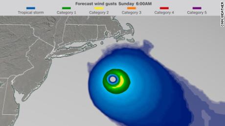
Henri has intensified to a Category 1 hurricane as it continues its path towards Connecticut.

A hurricane warning is in effect for New Haven, Middlesex, and New London counties.
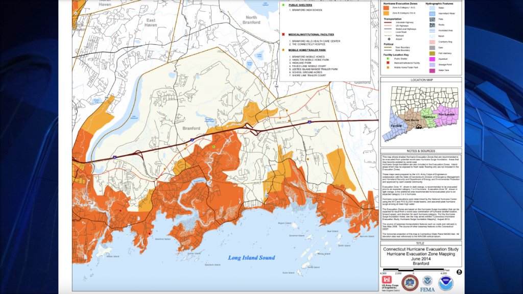
Branford

Residents in evacuation zones 1 and 2 along the shore, in low-lying areas, and those prone to flooding will have to evacuate their homes no later than 7 a.m. Sunday.

Officials said that if you live outside the designated zones but your home is prone to flooding, you should make preparation to evacuate.

“Any residents who do not leave the evacuation zone by 7 a.m. Sunday are putting their lives at risk, public safety crews may not be able to respond to help once winds exceed 50 mph,” the Town of Branford Emergency Operations Center said.


Branford Police Department

A shelter will be open at Branford High School on East Main Street for evacuees starting at 6 p.m. Saturday. The shelter has accommodations for pets if absolutely necessary. For more information, click here.

East Haven

Dozens of streets are in a mandatory evacuation zone in East Haven. City officials say residents in the below areas must be evacuated from their homes by 9 p.m. Saturday.

  • Atwater Street
  • Atwater Street Extension
  • Beach Ave
  • Beachside Avenue
  • Brazos Road
  • Bradford Avenue
  • Cambridge Court
  • Canna Drive
  • Caroline Road
  • Catherine Street
  • Center Avenue
  • Coe Avenue between Cosey Beach Avenue and Wilkenda Avenue
  • Cold Spring Street
  • Cosey Beach Avenue
  • Cosey Beach Avenue Extension
  • Cosey Beach Road
  • Dewey Avenue
  • Ellis Road
  • Farview Road
  • First Avenue
  • George Street between Bradford Avenue and Wilkenda Avenue
  • Hampton Road
  • Henry Street between Bradford Avenue and Wilkenda Avenue
  • Hobson Street
  • Fairview Road
  • First Avenue
  • Jamaica Court
  • Maturo Drive
  • Meadow Place east of North Atwater Street
  • Minor Road
  • Montouk Street
  • Morgan Avenue
  • Morgan Terrace
  • Morris Avenue
  • North Atwater Street
  • Old Town Highway
  • Palmetto Trail
  • Pequot Street
  • Phillip Street
  • Roses Farm Road
  • Second Avenue
  • Seaview Avenue
  • Shell Beach Road
  • Sibley Lane
  • Silver Sands Road between South Shore Drive and South End Road
  • Smith Street
  • South End Road
  • South Shore Drive
  • South Street
  • Stanton Road
  • Stoddard Road
  • Supa Drive
  • South Shore Drive
  • Stevens Street between Bradford Avenue and Wilkenda Avenue
  • Stoddard Road
  • Wilkenda Avenue

Anyone who chooses not to evacuate from the above areas will not be accessible by emergency crews until the storm subsides.

Groton

  • Shore Avenue
  • South Prospect Street
  • Beach Pond Road
  • Pine Island Road
  • Jupiter Pond Road

On Friday, the city of Groton recommended that residents who live on the above streets evacuate during the storm. Now, evacuation is mandatory.

The city says that emergency personnel may not be able to reach residents in these areas who choose to stay home during the storm because of potential flooding.

Guilford

A mandatory evacuation is in effect for residents living in coastal and/or low-lying areas. Other areas prone to flooding due to storm surges should also evacuate immediately.

The mandatory evacuation is in effect because the town can’t assure that emergency personnel will be able to reach you should you require assistance, officials said.

Anyone in need of a place to stay is welcome at 32 Church St., which is accepting residents until midnight. The shelter will also accept residents beginning at 6 a.m. on Sunday. Masks are required and people are asked to bring their own toiletries, bedding, sleeping attire, and non-perishable food. Cots will be available. Pets who are brought to the shelter must be in a pet carrier.

Eversource and United Illuminating are preparing for Tropical Storm Henri as it continues its path towards Connecticut

“I encourage all residents living in impacted areas to take this evacuation order seriously, for their own safety and the safety of our first responders,” First Selectman Matt Hoey said.

Madison

The Town of Madison has issued a mandatory evacuation order for all residents south of the Boston Post Road ahead of Hurricane Henri making landfall.

Messages were sent to all affected residents on Saturday.

Everyone in the evacuation zone must be out of the area by 9 p.m. Saturday night, according to Madison town officials.

The order was given due to concerns over significant storm surge and coastal flooding expected from Henri.

“Any residents who do not leave the evacuation zone by 9 p.m. tonight are putting their lives at risk and public safety crews will not be able to respond to you once winds exceed 50 MPH,” a message on the Madison town website said.

Town leaders are asking anyone who lives outside the evacuation zone, but has experienced flooding during prior storms, to be prepared to evacuate if conditions change.

Madison is opening an emergency shelter at the Town Campus Gym at 8 Campus Drive at 5 p.m. Saturday. The shelter can accommodate pets if necessary.

Read original article here

Tracking Henri LIVE: Hurricane and tropical storm warnings issued for Long Island, NYC and parts of the Tri-State

NEW YORK (WABC) — With much of New York state and Connecticut under states of emergencies, Hurricane Henri is threatening to bring severe storm surges, heavy rain, flooding, and strong winds on Sunday to the region, with Long Island facing its first direct hit from a hurricane in almost 36 years. The storm will unleash life-threatening surges and flooding, as well, in Connecticut and throughout New York state.

“New Yorkers, please take this storm seriously. I know it’s short notice. Think Superstorm Sandy,” Gov. Andrew Cuomo said in a briefing Saturday afternoon where he declared a state of emergency for large parts of New York state. “It is as serious as a heart attack,” he said. “The people of the state have had less notice to fully actualize what might happen here.”

“I understand the instinct of “we’re going to shelter in place …” but that decision to ride it out could be a dangerous one, the governor said.

At 11 a.m. Saturday, the storm was upgraded to hurricane status, with maximum sustained winds of 75 mph, but gusts, when the storm reaches the area, could be as high as 100 mph.

The effects of Henri will be felt as soon as Saturday night, with worsening conditions Sunday culminating in landfall over eastern Long Island early Sunday afternoon. Henri will then head into Connecticut and march north closer to the New York border, leaving a path of destruction that could include flash flooding and damage to homes and utility lines that could knock out power for days.

Hurricane and Tropical Storm Warnings remain in effect as heavy rain could drop 2 to 7 inches of precipitation with even more in spots. Coastline surges of 2 to 5 feet are expected, with the greatest, life-threatening swells on eastern Long Island and coastal Connecticut.

In upstate New York, flood-prone creeks and other bodies of water could also overflow, putting life and property at risk. Sustained power outages and significant damage to property are also expected, and officials urged residents to prepare for the storm while they can, ahead of deteriorating conditions starting Saturday night.

Cuomo has declared a state of emergency for Long Island, New York City, Westchester County, the Hudson Valley, and the Capital District. Those areas in upper New York state are facing considerable flooding risks, similar to damage the region saw after hurricanes Irene in 2011 and Sandy in 2012.

The governor also called on 500 National Guard members to assist ahead of Henri’s arrival.

“Conditions will deteriorate rapidly later tonight and become dangerous tomorrow. Henri will deliver life-threatening storm surge, damaging winds, and flooding rain. Be ready for the possibility of prolonged power outages. Take this storm seriously. Secure loose items around your property. If you are near the coast have a plan to seek higher ground,” ABC7 chief meteorologist Lee Goldberg advises.

This will likely be the first hurricane to make landfall on Long Island since Gloria in 1985. Unlike Gloria, this storm will slow down and move inland across Connecticut, the Mid-Hudson Valley, and central New England causing widespread damage.

Forecast in detail

The latest advisories, watches and warnings from the National Weather Service

Wind threat

Here’s how the National Weather Service is breaking it down:

EASTERN LI AND SE COASTAL CONNECTICUT: Winds could be 75 mph with gusts of 90-100 mph, with the worst Sunday morning into the afternoon. The ferocious winds could cause extensive damage and uprooting of trees, power lines, and poles. Damage to roofs and siding as well as significant damage to mobile homes could happen.

NASSAU COUNTY, SOUTHWEST CONNECTICUT, SOUTHERN WESTCHESTER, INTERIOR COASTAL CONNECTICUT: Winds could be 50-60 mph with sustained gusts of 70-80 mph, with the worst Sunday morning into the afternoon. Widespread tree and power line damage similar to Tropical Storm Isaias last August is likely.

NYC/NJ METRO COUNTIES: Winds of 30 to 40 mp with 50-60 mph gusts are expected starting Sunday morning but could begin late Saturday. Scattered tree and power line damage are possible.

Surge threat

EASTERN LI BAYS/TWIN FORKS/LI SOUND/OCEAN BEACHFRONT: Life-threatening inundation threats of 3 to 4 and locally 5 feet in vulnerable spots are expected.

SOUTHERN BAYS OF WESTERN LI AND QUEENS: Moderate to locally major inundation threats of 2 to 3 feet, locally 4 feet are expected. (Great South Bay)

NY/NJ HARBORS: Minor inundation threat of 1 to 2 feet is expected.

Rainfall amounts

Three to 7 inches with locally higher amounts for much of Connecticut and eastern Long Island are expected by Monday. 2 to 4 inches with locally higher amounts are on tap for the rest of area.

Most widespread and heaviest rainfall likely will happen late Saturday night into Sunday night. Rain could linger into Monday.

The heavy rain will bring with the risk of flash floods.

Shoreline

Surf heights could reach 8 to 12 feet on western LI beaches and 12 to 18 feet on eastern LI beaches, causing dune erosion and possible dune breaches on vulnerable eastern Long Island barrier islands.

Off shore, wave heights could be 15 to 20 feet, particularly east of Moriches Inlet.

Official warnings
A Hurricane Warning is in effect for the south shore of Long Island from Fire Island Inlet to Montauk Point, the North shore of Long Island from Port Jefferson Harbor to Montauk Point and New Haven, Connecticut, to west of Watch Hill, Rhode Island.

A Tropical Storm Warning is in effect for Port Jefferson Harbor to west of New Haven Connecticut, the south shore of Long Island from west of Fire Island Inlet to East Rockaway Inlet, Coastal New York and New Jersey west of East Rockaway Inlet to Manasquan Inlet, including New York City.

One of the biggest issues will be the storm surge from New York City to Cape Cod.

A Storm Surge Warning is in effect from Queens, New York across Long Island. A Storm Surge Warning means there is a danger of life-threatening inundation, from rising water moving inland from the coastline, during the next 36 hours in the indicated locations.

RELATED: What is storm surge and why is it dangerous?

As of 5 p.m. ET, Henri had maximum sustained winds of 75 miles per hour and was about 335 miles south of Montauk Point/.

The current guidance from the National Hurricane Center:

1. Dangerous storm surge inundation is expected to begin late
tonight or Sunday in portions of Long Island, Connecticut,
Rhode Island, and southeastern Massachusetts, where a Storm Surge
Warning has been issued. Dangerous storm surge is possible
beginning late tonight or Sunday in western portions of Long
Island and Connecticut in the Storm Surge Watch area. Residents in
these areas should follow any advice given by local officials.

2. Hurricane conditions are expected to begin late tonight or
Sunday in portions of Long Island and Connecticut, where a
Hurricane Warning has been issued. Hurricane conditions are

possible late tonight or Sunday across portions of Rhode Island.

3. Heavy rainfall may lead to considerable flash, urban, and small
stream flooding, along with the potential for widespread minor and
isolated moderate river flooding, over portions of Long Island, New
England, southeast New York and northern New Jersey.

4. Swells from Henri will continue to affect much of the east coast
of the U.S. through the weekend. These swells could cause
life-threatening surf and rip currents.

Additional Henri Coverage

Tracking Henri Live

Long Island prepares for Henri

Connecticut braces for Henri

How mass transit is preparing for Henri

New York City beaches closed Sunday and Monday

What is storm surge and why is it dangerous?

Emergency Resources for severe weather

Weather or Not with Lee Goldberg’s extreme weather survival guide

Share your weather photos and videos, and Eyewitness News may show them on TV or any of our digital and social platforms

———-
* Get the AccuWeather App
* More AccuWeather
* Follow us on YouTube
* More local news
* Sign up for free newsletters
* Download the abc7NY app for breaking news alerts Submit a News Tip

Copyright © 2021 WABC-TV. All Rights Reserved.


Read original article here

Tropical Storm Henri live updates: Now Category 1 hurricane

New York Gov. Andrew Cuomo declared a state of emergency for Long Island, New York City, Hudson Valley, Westchester, and the Capital District region on Saturday as Henri is expected to make landfall Sunday in Long Island.

“The state is doing everything we can to be ready. We’re prepositioning emergency equipment all through Long Island, Hudson Valley, we’re preparing water rescue teams for Long Island and the Hudson Valley and in Westchester,” he said in a press briefing Saturday.

He said if Henri hits as a Category 1 hurricane it’ll bring 80 mph winds, gusts up to 90 to 100 mph, and storm surge between 3 to 6 feet.

He warned locals to remember Superstorm Sandy, saying “This is right now projected to be that level of a storm. It is as serious as a heart attack.”

Cuomo said he is activating 500 National Guardsmen with necessary emergency equipment such as high water vehicles and the state will have 1,000 personnel on duty in the affected areas.

Port Authority expects flights to be cancelled and the Metropolitan Transportation Authority will cancel service in Long Island starting at midnight, he said.

He urged locals who live in areas prone to flooding to leave immediately for higher ground.

Read original article here

Henri strengthens to hurricane as it bears down on the Northeast

Plymouth, Massachusetts —  Parts of the Northeast could begin to feel the effects of Hurricane Henri as soon as late Saturday, as the storm barrels toward the region.

Forecasters said Henri was expected to remain at or near hurricane strength when it makes landfall midafternoon Sunday, which the hurricane center said could be on New York’s Long Island or in southern New England — most likely Connecticut. The upgrade in status came with the National Hurricane Center’s 11 a.m. advisory.

Storm surge and the tide could cause high water in coastal New England as Henri moves inland, the Miami-based National Hurricane Center said in an advisory. Heavy rain and wind may also produce flooding.

Henri was veering a bit further west than originally expected, and if that track holds, it would have eastern Long Island in its bullseye rather than New England, which hasn’t taken a direct hit from a hurricane since Hurricane Bob in 1991, a Category 2 storm that killed at least 17 people.

New York hasn’t had a direct hit from a major hurricane season storm since Superstorm Sandy wreaked havoc in 2012.

Regardless of its exact landfall, broad impacts were expected across a large swath of the Northeast, extending inland to Hartford, Connecticut, and Albany, New York, and eastward to Cape Cod, which is teeming with tens of thousands of summer tourists.

Massachusetts Governor Charlie Baker urged people vacationing on the Cape to leave well before Henri hits, and those who planned to start vacations there to delay their plans. “We don’t want people to be stuck in traffic on the Cape Cod bridges when the storm is in full force on Sunday,” he said.

With a top wind speed of 75 mph Saturday morning, Henri sped up slightly to move north-northeast at 14 mph. It’s still about 465 miles south of Montauk on New York’s Long Island.

Governor Ned Lamont warned Connecticut residents they should prepare to “shelter in place” from Sunday afternoon through at least Monday morning as the state braces for the first possible direct hit from a hurricane in decades.

“This storm is extremely worrisome,” said Michael Finkelstein, police chief and emergency management director in East Lyme, Connecticut. “We haven’t been down this road in quite a while and there’s no doubt that we and the rest of New England would have some real difficulties with a direct hit from a hurricane.”

This image shows the projected path of Hurricane Henri.

National Hurricane Center


The hurricane center storm surge between 3 and 5 feet was possible with Henri from Flushing, New York, to Chatham, Massachusetts; and for parts of the North Shore and South Shore of Long Island.

Rainfall between 3 to 6 inches was expected Sunday through Monday over the Northeast.

The weather service warned of the potential for damaging winds and widespread coastal flooding from Henri, and officials in Massachusetts, Connecticut and New York cautioned that people could lose power for a week or even longer. Authorities urged people to secure their boats, fuel up their vehicles and stock up on canned goods.

New York state park officials were building a wall of sand along the boardwalk at Jones Beach to protect it against surging tides, said George Gorman, the regional director for state parks on Long Island. The wall was being built with equipment procured in the wake of Hurricane Sandy, which caused substantial damage to beaches that took months to reopen, he said.

Campgrounds were expected to be closed starting Saturday afternoon and remain off-limits until Tuesday.

At Safe Harbor Marina in coastal Plymouth, Massachusetts, Steve Berlo was among the many boaters having their vessels pulled out of the water ahead of the storm. “It’s rare, but when it happens, you want to be sure you’re ready,” 54-year-old Berlo said. “Got to protect our second home.”

In the Hamptons, the celebrity playground on Long Island’s east end, officials warned of dangerous rip currents and flooding that’s likely to turn streets, like mansion-lined Dune Road on the Atlantic coast, into lagoons.

Ryan Murphy, the emergency management administrator for the Town of Southampton, said that while the storm’s track continues to evolve, “we have to plan as if it’s going to be like a Category 1 hurricane that would be hitting us.”

Read original article here

Warnings Issued as Henri Threatens Hurricane-Strength Winds From Long Island to Nantucket

Tropical Storm Henri is expected to become a hurricane on Saturday and make landfall in Long Island or southern New England on Sunday, according to meteorologists.

A hurricane warning was issued Friday evening for parts of Long Island and the Connecticut coast. A storm surge warning, which is issued when there is a danger of life-threatening flooding from rising water, was also in effect for parts of Long Island, Connecticut and Massachusetts, including Nantucket and Martha’s Vineyard, the National Hurricane Center said.

A tropical storm warning was in effect for areas from Manasquan, N.J., to west of East Rockaway, N.Y., including New York City, the hurricane center said.

On Friday evening, Gov. Ned Lamont of Connecticut declared a state of emergency to provide the state with federal assistance needed for storm response.

Hurricane-strength winds in Northeastern states like Connecticut, Rhode Island and Massachusetts would be unusual, should they arrive. The last time a hurricane made landfall in New England was 30 years ago.

By Friday night, Henri was “almost a hurricane,” according to the hurricane center, with maximum sustained winds of 70 miles per hour. The storm is expected to be at or near hurricane strength when it makes landfall on Sunday.

Henri was moving north at nine miles per hour late Friday night and was expected to accelerate in that direction through early Sunday, the hurricane center said.

As of late Friday night, Henri was 230 miles south-southeast of Cape Hatteras, N.C.

Of three storms that recently formed in the Atlantic Ocean, Henri, which developed on Monday off the East Coast of the United States, formed most recently. Most of the attention early this week was on Tropical Depression Fred, which made landfall in the Florida Panhandle on Monday afternoon as a tropical storm, and Hurricane Grace, which came ashore in Haiti as a tropical depression before making landfall as a hurricane on the Yucatán Peninsula in Mexico on Thursday. It made landfall on the east coast of Mexico’s mainland early Saturday.

Henri is expected to dump up to six inches of rain over New England on Sunday and Monday, with isolated totals near 10 inches. Heavy rainfall across the area could bring some flooding. Some coastal areas could experience storm surges as high as five feet.

The National Hurricane Center said on Friday night that “heavy rainfall may lead to considerable flash, urban and small stream flooding” over portions of Long Island and New England on Sunday and Monday.

The National Weather Service in New York said that in Long Island and Connecticut, destructive winds, life-threatening storm surges and heavy rainfall were all likely.

In New York City and parts of New Jersey, there is a chance of winds of 30 to 40 miles per hour on Sunday, according to the Weather Service.

“The most likely arrival time of tropical storm force winds across the tristate area is early Sunday morning,” the Weather Service said in a Friday night briefing. “However, the region could see tropical storm force winds as early as Saturday night.”

When Hurricane Bob hit New England in 1991, it killed at least a dozen people, brought down power lines and wrecked houses as neighborhoods flooded.

Gov. Charlie Baker of Massachusetts said on Friday that residents and vacationers in Cape Cod should leave the area before the storm reached full force on Sunday. He said he was prepared to deploy up to 1,000 National Guard troops to help with evacuations if necessary.


How to Decode Hurricane Season Terms

Karen Zraick and Christina CaronReporting on the weather 🌬️

How to Decode Hurricane Season Terms

Karen Zraick and Christina CaronReporting on the weather 🌬️

Emily Kask for The New York Times

What is “landfall”? And what are you truly facing when you’re in the eye of the storm?

During hurricane season, news coverage and forecasts can include a host of confusing terms. Let’s take a look at what they mean

Item 1 of 6

While it is not uncommon for several weather systems to be active at once during hurricane season, forecasters with the National Hurricane Center said, it is somewhat unusual for there to be three at the same time that have prompted tropical storm watches or warnings for land areas.

“It’s a busy period here,” Michael Brennan, the branch chief of the center’s hurricane specialist unit, said on Monday.

The links between hurricanes and climate change are becoming more apparent. A warming planet can expect stronger hurricanes over time, and more of the most powerful storms — though the overall number of storms could drop, because factors like stronger wind shear could keep weaker storms from forming.

Hurricanes are also becoming wetter because there is more water vapor in the warmer atmosphere; scientists have suggested that storms like Hurricane Harvey in 2017 produced far more rain than they would have without the human effects on climate. Rising sea levels are also contributing to higher storm surges, the most destructive element of tropical cyclones.

A major United Nations climate report released this month warned that nations have delayed curbing their fossil-fuel emissions for so long that they can no longer stop global warming from intensifying over the next 30 years, leading to more frequent life-threatening heat waves and severe droughts. Tropical cyclones have probably become more intense over the past 40 years, the report said, a shift that cannot be explained by natural variability alone.

Ana became the first named storm of the season on May 23, making this the seventh year in a row that a named storm developed in the Atlantic before the official start of the season on June 1.

In May, scientists with the National Oceanic and Atmospheric Administration forecast that there would be 13 to 20 named storms this year, six to 10 of which would be hurricanes, and three to five major hurricanes of Category 3 or higher in the Atlantic. In early August, in a midseason update to the forecast, they continued to warn that this year’s hurricane season would be an above-average one, suggesting a busy end to the season.

Matthew Rosencrans, of the National Oceanic and Atmospheric Administration, said that an updated forecast suggested that there would be 15 to 21 named storms, including seven to 10 hurricanes, by the end of the season on Nov. 30. Henri is the eighth named storm of 2021.

Last year, there were 30 named storms, including six major hurricanes, causing meteorologists to exhaust the alphabet for a second time and move to using Greek letters.

It was the highest number of storms on record, exceeding the 28 in 2005, and included the second-highest number of hurricanes on record.

Derrick Bryson Taylor, Neil Vigdor, Jesus Jiménez, Jacey Fortin and Eduardo Medina contributed reporting.

Read original article here

Tropical storm Henri is forecast to make a rare landfall as a hurricane in New York or southern New England

The track continues to shift slightly west, closer to Long Island, according to the 11 a.m. Friday update from the NHC.

“The risks of storm surge, wind, and rain impacts in portions of southern New England and eastern Long Island are increasing,” the center said Friday morning.

The last time a hurricane made landfall in this region was Hurricane Bob in 1991. But hurricanes have made signficant impacts since then. Irene and Sandy brought devastating conditions even though they did not make landfall as a hurricane.

A direct landfall as a hurricane means the worst winds will make it onshore.

Forecast models Friday morning are in better agreement than they were two days ago. But there is still some mystery concerning Henri’s path, intensity and effects through early next week.

“Given the still-present uncertainties in Henri’s future track and intensity and the hazards that the storm may cause, storm surge and hurricane watches are now being issued for portions of Long Island, Connecticut, Rhode Island, and southeastern Massachusetts,” the hurricane center says.

A hurricane watch means that hurricane conditions are possible within the watch area. A watch is typically issued 48 hours before the anticipated first occurrence of tropical storm-force winds.

Based on the new forecast, tropical storm-force winds will be approaching the coast of southern New England in about 48 hours, the NHC said.

“This is the first time in nearly 10 years that we’ve had a Hurricane Watch issued for portions of our area,” tweeted the National Weather Service (NWS) in New York. “The last time we had Hurricane Watches issued for the area was for Hurricane Irene back in late August of 2011.”

Wind shear — the changing of wind speed and direction with height — has been keeping Henri from strengthening the past few days. That shear is expected to end today, allowing Henri to reach hurricane status by Saturday.

Cooler waters near the coast typically weaken a hurricane, but Henri is forecast to move fast enough for these cooler waters to not have much of an effect.

As the storm makes landfall, damaging winds and storm surges are the most significant threats.

“Keep in mind tides will be astronomically high this weekend along both coasts,” says the NWS in Boston.

The full moon Sunday means higher high tides. Any storm surge on top of already higher tides could trigger enhanced coastal flooding.

“Track will ultimately tell us which coastline is most at risk (east coast vs south coast) or if both will be in play,” the Boston NWS said Thursday.

A storm surge of 3 to 5 feet has been forecast from Cape Cod Bay to Narragansett Bay, a surge of 2 to 4 feet is expected for the coastline of Connecticut and New York, including Long Island, and 1 to 3 feet is forecast along the New Jersey Coast down to Cape May.

A storm surge watch has also been issued for much of the region. A Storm Surge Watch means there is a possibility of life-threatening inundation from rising water moving inland from the coastline.

Heavy rainfall will also be a threat during the day Sunday and into the beginning of next week. Henri is forecast to produce rain of 2 to 5 inches over southern New England, with isolated maximum totals near 8 inches.

“Generally by the time storms make it to New England, they are getting picked up by the jet stream and are moving very quickly,” says CNN meteorologist Brandon Miller. “It will be very rare for a storm to move this slowly over the Northeast.”

That means that storm surge, dangerous surf, coastal erosion, and heavy rain will continue to batter New England for days instead of hours.


Read original article here