Tag Archives: floods

Perseverance rover finds evidence of ancient floods on Mars, researchers say

The Perseverance rover, which spent months traveling to Mars, could hardly have landed in a more interesting spot. 

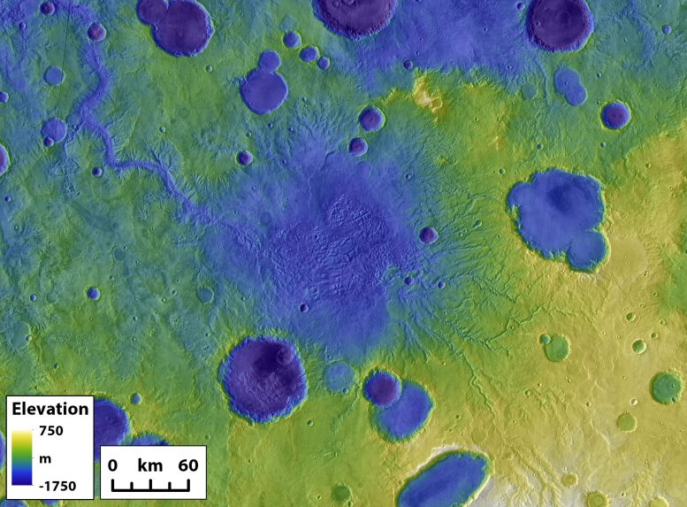
The Jezero crater — a dry, wind-scoured patch of Martian rock where the rover touched down in February — was once a lake bed fed by an ancient river with floods so powerful they could move boulders, scientists say. 

Those findings, published last week in the journal Science, confirmed scientists’ suspicions that the crater contained a lake millions of years ago, and also suggests that this part of Mars had a warm, humid past with a more complicated water cycle than was known. 

“There were rushing rivers here,” Katie Stack Morgan, a deputy project scientist of the Mars 2020 project and an author of the paper, said of Jezero’s landscape some 3.5 million years ago. “Jezero might have been a good place for life to exist and that environment evolved over time.”

Further studies could help researchers understand why the planet dried out and provide new clues about whether the planet once supported life. 

A view from the ground

New perspective — thanks to Perseverance — and geological detective work by scientists made these insights possible. 

The rover, which transmitted imagery from the crater’s surface back to Earth, provided scientists new views that couldn’t be seen from space.

“What you think you’re seeing from orbit around Mars may not be what you see when you get into the crater at eye level,” Stack Morgan said.

The surface-level images supported scientists’ theory that Jezero once featured a deep lake. 

The images also gave scientists, including the 39 authors of the Science paper, the ability to further analyze the layers of a rock on an outcropping called Kodiak. Researchers found those layers were consistent with how river deltas appear on Earth, suggesting water flowed into the ancient lake. 

But the visuals also contained a few surprises. On other cliffs near Kodiak, the scientists noticed large boulders — some as wide as five feet across and shaped by water — within upper layers of the formations, according to the Science paper.

They suspect the boulders were deposited during massive flash flooding events powerful enough to rapidly transform the Martian watershed. 

They don’t know what caused these floods, but speculated in the paper that intense rainfall, rapid snowmelt or changes to glacier ice could have sent floodwaters raging. 

“It could be very difficult to reconstruct that kind of thing,” Stack Morgan said.

Looking for signs of life

Perseverance is the first rover to collect and cache Martian rock samples. 

Stack Morgan said it’s exciting to know with certainty the rover will visit and collect samples from an ancient lake that was fed by a river.

That means the rover will have access to a diversity of rock types that were deposited to the crater. The rover also should be able to reach and sample portions of ancient lake beds, which are “exactly the kind of beds on earth that are great for organic material and biosignatures,” she said.

The rover could be in the right place to answer some of humankind’s deepest questions.

“That’s why we came to Jezero with Perseverance,” she said. “So far, Jezero has not disappointed.” 

Read original article here

As Floods Ravage China, 14 Die After Bus Falls Off Bridge

For the second time in three months, China is grappling with the aftermath of violent floods caused by days of unusually intense rains that have left at least 29 people dead and displaced more than 120,000 across northern parts of the country.

The death toll included 14 people who died after a commuter bus fell into a river on Monday from a flooded bridge near the northern city of Shijiazhuang, according to Chinese media reports. Video circulating online showed stranded passengers waiting to be rescued on the roof of the nearly submerged bus as it floated in the river. As of Monday night, 37 people had been rescued from the bus, according to CCTV, China’s state broadcaster.

They have also exposed the vulnerability of China’s energy supply. Shanxi Province, China’s coal country, was among the hardest-hit regions of last week’s floods, with torrential rains leaving at least 15 people dead. The flooding also caused operations in 60 coal mines in the province to be suspended, according to Chinese state news media. The disruption comes as the government has been struggling to overcome an electricity shortage and nationwide blackouts caused partly by rising energy prices and soaring demand.

The heaviest rains occurred last week, while many were traveling for China’s seven-day national holiday known as Golden Week. Chinese state news media emphasized that 600 mines in Shanxi Province remained operational and that many workers had given up their holiday plans to make sure that they could continue producing coal. Two-thirds of China’s electricity comes from coal.

In addition to the mine closures, the floods disrupted rail service on several lines in Shanxi Province and caused part of the ancient city wall of Pingyao, one of China’s best-preserved medieval towns, to collapse. At least 17,000 buildings were destroyed and large areas of farmland were flooded, according to state news media. Other regions affected by the recent floods include the northern provinces of Hebei and Shaanxi.

While the death toll in the latest round of floods appears to be lower than in July, many people on Chinese social media asked why local media had scant coverage of the disaster. Hu Xijin, the editor of the Communist Party-owned Global Times newspaper, wrote on his Weibo social media account on Saturday that the Shanxi floods had received less attention because the casualties had been minimal and the flood-relief efforts had gone smoothly, contributing to the “stability of the country” during the holiday.

Some commenters on social media seemed to suggest otherwise. On Sunday, a person took to Weibo to plead for help for people in the remote village of Nanfenggou, in rural Shanxi Province.

“There are all old people, and the electricity and water have been cut off,” the user wrote. “We don’t know if there is enough food.”

Read original article here

Photos from NASA’s Perseverance rover indicate ancient flash floods on Mars

A new study from the team behind NASA’s Perseverance Mars rover reveals that areas of Mars — specifically the Jezero Crater, an area scientists think may hold keys to ancient Martian life — experienced “significant” flash floods that carved the landscape into the rocky wasteland we see today. 

The team says they based their findings on images the rover took of sediment that gathered at the end of an ancient river that fed a lake inside the Jezero Crater. 

The photos, taken during a landing on February 18 and published on Thursday, suggest that billions of years ago, Mars had a thick atmosphere that could support large quantities of water. The sediment seen in the pictures shows a now-barren river delta that experienced “late-stage flooding events” whose waters carried boulders and debris from Mars highlands to the banks of the crater. 

“Never before has such well-preserved stratigraphy been visible on Mars,” said lead author Nicolas Mangold from the Laboratoire de Planétologie et Géodynamique. “This is the key observation that enables us to once and for all confirm the presence of a lake and river delta at Jezero. Getting a better understanding of the hydrology months in advance of our arrival at the delta is going to pay big dividends down the road.”

The NASA team has, according to their press release, “long planned to visit the delta” leading into the Jezero Crater due to the potential that it may contain fossils of ancient microbial life. 

The collected images have given the scientists information into where they can find the best rock samples to find the traces of life that may have once existed on Mars, which scientists hope they can bring back to Earth to analyze with more powerful lab equipment. The evidence of so much ancient water brings the scientists hope. 

“We saw distinct layers in the scarps containing boulders up to 5 feet across that we knew had no business being there,” said Mangold.

Mangold and his team believe that the flash floods that carried these boulders — some for tens of miles — would have moved at 4 to 20 mph. 

Sanjeev Gupta, from Imperial College, London, and a co-author of the paper, says the findings “could potentially provide valuable insights into why the entire planet dried out” and what happened to the ancient microbial life. 

NASA next plans to send spacecraft to Mars to collect the rock samples and return them to Earth. 

Read original article here

Existence of Mars lake, floods confirmed by NASA’s Perseverance team

NASA’s Perseverance Mars rover team has confirmed that the red planet’s Jezero Crater was once the site of a delta-lake system. 

In a study published Thursday in the journal Science, the researchers also wrote that images from the rover – taken in the three months after Perseverance landed in February – suggest the area experienced significant late-stage flooding events.

WHY NASA’S MARS MISSIONS WILL BE SILENT FOR WEEKS

The images were taken of long and steep slopes called escarpments, or “scarps,” in the delta, which reportedly formed from sediment at the mouth of an ancient river that fed the lake.

The photos revealed that the fan-shaped delta had outcrop faces the team said had been invisible from orbit and record the hydrological evolution of the crater.

The rock outcrop “Kodiak” had only been imaged from orbit, but images revealed its stratigraphy along the eastern face, showing layering that a geologist would expect to find in a river delta on Earth.

This image of “Kodiak” – one remnant of the fan-shaped deposit of sediments inside Mars’ Jezero Crater known as the delta – was taken by Perseverance’s Mastcam-Z instrument on Feb. 22, 2021.
(Credits: NASA/JPL-Caltech/ASU/MSSS)

“We interpret the presence of inclined strata in these outcrops as evidence of deltas that advanced into a lake. In contrast, the uppermost fan strata are composed of boulder conglomerates, which imply deposition by episodic high-energy floods,” the study’s authors wrote. “This sedimentary succession indicates a transition, from a sustained hydrologic activity in a persistent lake environment, to highly energetic short-duration fluvial flows.”

“Never before has such well-preserved stratigraphy been visible on Mars,” Nicolas Mangold, a Perseverance scientist from the Laboratoire de Planétologie et Géodynamique in Nantes, France, and lead author of the paper, said in a NASA release. “This is the key observation that enables us to once and for all confirm the presence of a lake and river delta at Jezero. Getting a better understanding of the hydrology months in advance of our arrival at the delta is going to pay big dividends down the road.”

The photos that led them to these conclusions were taken by Perseverance’s left and right Mastcam-Z cameras in addition to its Remote Micro-Imager.

MARS IMAGES SHOW PERSEVERANCE ROVER AT WORK

NASA said that the images also provided the team with insight into where they could best look for rock and sediment samples to collect and cache.

Farther up the scarps, Mastcam-Z and RMI found stone and boulders which the team said must have been carried by fast-moving flash flooding.

“These results also have an impact on the strategy for the selection of rocks for sampling,” Sanjeev Gupta, a Perseverance scientist from Imperial College, London, and a co-author of the paper, said in a statement. “The finest-grained material at the bottom of the delta probably contains our best bet for finding evidence of organics and biosignatures. And the boulders at the top will enable us to sample old pieces of crustal rocks. Both are main objectives for sampling and caching rocks before Mars Sample Return.”

This annotated image indicates the locations of NASA’s Perseverance rover (lower right), as well as the “Kodiak” butte (lower left) and several prominent steep banks known as escarpments, or scarps, along the delta of Jezero Crater.
(Credits: NASA/JPL-Caltech/University of Arizona/USGS)

Lastly, the scientists described the water level of Jezero’s lake as fluctuating by tens of yards before its disappearance – though it is not known if the changes resulted from flooding or more gradual, environmental shifts. 

The team has determined that the changes occurred later in the delta’s history and that lake levels were at least 330 feet below the highest level.

“A better understanding of Jezero’s delta is a key to understanding the change in hydrology for the area,” Gupta noted, “and it could potentially provide valuable insights into why the entire planet dried out.”

NASA believes Mars dried out approximately 3.5 billion years ago and that the lake existed around 3.7 billion years ago.

CLICK HERE TO GET THE FOX NEWS APP

The delta will be the site for the rover team’s second science campaign in 2022.

“We now have the opportunity to look for fossils,” team member Tanja Bosak, associate professor of geobiology at MIT, told MIT News. “It will take some time to get to the rocks that we really hope to sample for signs of life. So, it’s a marathon, with a lot of potential.”

Read original article here

At flooded restaurant near Bangkok, the special is a splash

NONTHABURI, Thailand (AP) — A flood-hit riverside restaurant in Thailand has become an unlikely dining hotspot after fun-loving foodies began flocking to its waterlogged deck to eat amid the lapping tide.

Now, instead of empty chairs and vacant tables, the Chaopraya Antique Café is as full as ever, offering an experience the canny owner calls “hot-pot surfing.”

If you like your food washed down with plenty of water, this is the place for you.

Shortly after the water tops the parapet, the first diners arrive. Before long, the deck is crammed with carefree customers happily tucking in as if dining in a deluge is the norm.

The wait staff — some clad in rubber boots — step gingerly through the swirl that quickly rises to more than 50 centimeters (20 inches).

The restaurant, in Nonthaburi near Bangkok, opened in February in a riverside location that perfectly complements its antique architecture and décor.

But a recent severe tropical storm and heavy monsoon rains combined to raise the river’s water level. Add in the tides and the result has been daily inundation.

Coming straight after a monthslong coronavirus shutdown, it could have spelled disaster. Instead — boosted by publicity in the Thai media — it’s now so popular that customers need to make reservations.

“This is a great atmosphere. During this flood crisis this has became the restaurant’s signature attraction. So I wanted to challenge myself and try out this new experience,” 24-year-old Siripoj Wai-inta said as he munched his food with the water creeping up his shins.

The owner has dubbed the experience “hot-pot surfing.” When a passenger boat motors past you find out why. The delighted scramble to avoid a soaking from the wave is the moment everyone waits for, and with one passing every 15 minutes, no one goes home disappointed.

It’s TV presenter Titiporn Jutimanon’s first restaurant venture. He says he was worried what would happen when the floods came.

“It turns out the customers have a great reaction. They are happy. We can see the atmosphere of customers enjoying the experience of eating in the water. So a crisis has turned into an opportunity. It encourages us to keep the restaurant open and keep customers happy.”

Best of all, he says, it means he can keep his staff happy by keeping them employed. So, even amid harsh economic times, the only thing that needs a bailout is the restaurant itself.

Read original article here

Fast and Furious Floods From Overflowing Craters Shaped the Surface of Mars

A colored topographical image showing river valleys on Mars. The outlet canyon Loire Vallis (white line) formed from the overflow of a lake in Parana Basin (outlined in white). Black lines indicate other river valleys formed by processes other than lake overflows. Background is colored Mars Orbiter Laser Altimeter-derived topography over a Thermal Emission Imaging System image mosaic. Image is approximately 650 kilometers across. Credit: NASA/GSFC/ JPL ASU

On Earth, river erosion is usually a slow-going process. But on

The remains of a former crater lake on Mars surrounded by other smaller craters. The large outlet canyon in the upper left formed during a crater breach event. Credit: Goudge et al.

Crater lakes were common on Mars billions of years ago when the Red Planet had liquid water on its surface. Some craters could hold a small sea’s worth of water. But when the water became too much to hold, it would breach the edge of the crater, causing catastrophic flooding that carved river valleys in its wake. A 2019 study led by Goudge determined that these events happened rapidly.

Remote sensing images taken by satellites orbiting Mars have allowed scientists to study the remains of breached Martian crater lakes. However, the crater lakes and their river valleys have mostly been studied on an individual basis, Goudge said. This is the first study to investigate how the 262 breached lakes across the Red Planet shaped the Martian surface as a whole.

The research entailed reviewing a preexisting catalog of river valleys on Mars and classifying the valleys into two categories: valleys that got their start at a crater’s edge, which indicates they formed during a lake breach flood, and valleys that formed elsewhere on the landscape, which suggests a more gradual formation over time.

A global map of Mars showing river valleys around the Red Planet. River valleys formed by crater lake breaches are in white. River valleys that formed gradually over time are in black. Credit: Goudge et al.

From there, the scientists compared the depth, length, and volume of the different valley types and found that river valleys formed by crater lake breaches punch far above their weight, eroding away nearly a quarter of the Red Planet’s river valley volume despite making up only 3% of total valley length.

“This discrepancy is accounted for by the fact that outlet canyons are significantly deeper than other valleys,” said study co-author Alexander Morgan, a research scientist at the Planetary Science Institute.

At 559 feet (170.5 meters), the median depth of a breach river valley is more than twice that of other river valleys created more gradually over time, which have a median depth of about 254 feet (77.5 meters).

In addition, although the chasms appeared in a geologic instant, they may have had a lasting effect on the surrounding landscape. The study suggests that the breaches scoured canyons so deep they may have influenced the formation of other nearby river valleys. The authors said this is a potential alternative explanation for unique Martian river valley topography that is usually attributed to climate.

The study demonstrates that lake breach river valleys played an important role in shaping the Martian surface, but Goudge said it’s also a lesson in expectations. The Earth’s geology has wiped away most craters and makes river erosion a slow and steady process in most cases. But that doesn’t mean it will work that way on other worlds.

“When you fill [the craters] with water, it’s a lot of stored energy there to be released,” Goudge said. “It makes sense that Mars might tip, in this case, toward being shaped by catastrophism more than the Earth.”

Reference: “The importance of lake breach floods for valley incision on early Mars” by Timothy A. Goudge, Alexander M. Morgan, Gaia Stucky de Quay and Caleb I. Fassett, 29 September 2021, Nature.
DOI: 10.1038/s41586-021-03860-1

The study’s other co-authors are Jackson School postdoctoral researcher Gaia Stucky de Quay and Caleb Fassett, a planetary scientist at the (function(d, s, id){ var js, fjs = d.getElementsByTagName(s)[0]; if (d.getElementById(id)) return; js = d.createElement(s); js.id = id; js.src = "https://connect.facebook.net/en_US/sdk.js#xfbml=1&version=v2.6"; fjs.parentNode.insertBefore(js, fjs); }(document, 'script', 'facebook-jssdk'));

Read original article here

Mars’ surface shaped by fast and furious floods from overflowing craters

A colored topographical image showing river valleys on Mars. The outlet canyon Loire Vallis (white line) formed from the overflow of a lake in Parana Basin (outlined in white). Black lines indicate other river valleys formed by processes other than lake overflows. Background is colored Mars Orbiter Laser Altimeter-derived topography over a Thermal Emission Imaging System image mosaic. Image is approximately 650 kilometers across. Credit: NASA/GSFC/ JPL ASU

On Earth, river erosion is usually a slow-going process. But on Mars, massive floods from overflowing crater lakes had an outsized role in shaping the Martian surface, carving deep chasms and moving vast amounts of sediment, according to a new study led by researchers at The University of Texas at Austin.

The study, published Sept. 29 in Nature, found that the floods, which probably lasted mere weeks, eroded more than enough sediment to completely fill Lake Superior and Lake Ontario.

“If we think about how sediment was being moved across the landscape on ancient Mars, lake breach floods were a really important process globally,” said lead author Tim Goudge, an assistant professor at the UT Jackson School of Geosciences. “And this is a bit of a surprising result because they’ve been thought of as one-off anomalies for so long.”

Crater lakes were common on Mars billions of years ago when the Red Planet had liquid water on its surface. Some craters could hold a small sea’s worth of water. But when the water became too much to hold, it would breach the edge of the crater, causing catastrophic flooding that carved river valleys in its wake. A 2019 study led by Goudge determined that these events happened rapidly.

Remote sensing images taken by satellites orbiting Mars have allowed scientists to study the remains of breached Martian crater lakes. However, the crater lakes and their river valleys have mostly been studied on an individual basis, Goudge said. This is the first study to investigate how the 262 breached lakes across the Red Planet shaped the Martian surface as a whole.

The remains of a former crater lake on Mars surrounded by other smaller craters. The large outlet canyon in the upper left formed during a crater breach event. Credit: Goudge et al.

The research entailed reviewing a preexisting catalog of river valleys on Mars and classifying the valleys into two categories: valleys that got their start at a crater’s edge, which indicates they formed during a lake breach flood, and valleys that formed elsewhere on the landscape, which suggests a more gradual formation over time.

From there, the scientists compared the depth, length and volume of the different valley types and found that river valleys formed by crater lake breaches punch far above their weight, eroding away nearly a quarter of the Red Planet’s river valley volume despite making up only 3% of total valley length.

“This discrepancy is accounted for by the fact that outlet canyons are significantly deeper than other valleys,” said study co-author Alexander Morgan, a research scientist at the Planetary Science Institute.

At 559 feet (170.5 meters), the median depth of a breach river valley is more than twice that of other river valleys created more gradually over time, which have a median depth of about 254 feet (77.5 meters).

A global map of Mars showing river valleys around the Red Planet. River valleys formed by crater lake breaches are in white. River valleys that formed gradually over time are in black. Credit: Goudge et al.

In addition, although the chasms appeared in a geologic instant, they may have had a lasting effect on the surrounding landscape. The study suggests that the breaches scoured canyons so deep they may have influenced the formation of other nearby river valleys. The authors said this is a potential alternative explanation for unique Martian river valley topography that is usually attributed to climate.

The study demonstrates that lake breach river valleys played an important role in shaping the Martian surface, but Goudge said it’s also a lesson in expectations. The Earth’s geology has wiped away most craters and makes river erosion a slow and steady process in most cases. But that doesn’t mean it will work that way on other worlds.

“When you fill [the craters] with water, it’s a lot of stored energy there to be released,” Goudge said. “It makes sense that Mars might tip, in this case, toward being shaped by catastrophism more than the Earth.”


Sustained planetwide storms may have filled lakes, rivers on ancient Mars


More information:
The importance of lake breach floods for valley incision on early Mars, Nature (2021). DOI: 10.1038/s41586-021-03860-1 , www.nature.com/articles/s41586-021-03860-1
Provided by
University of Texas at Austin

Citation:
Mars’ surface shaped by fast and furious floods from overflowing craters (2021, September 29)
retrieved 29 September 2021
from https://phys.org/news/2021-09-mars-surface-fast-furious-craters.html

This document is subject to copyright. Apart from any fair dealing for the purpose of private study or research, no
part may be reproduced without the written permission. The content is provided for information purposes only.


Read original article here

Floods Have Swamped the US. The Next Health Problem: Mold

There’s a long history of natural disasters making people sick. Reports range from cases of Valley fever after the Northridge earthquake in California in 1994 tossed dirt containing spores of Coccidia bacteria into the air, to aspergillus infections caused by victims of the 2011 Japanese tsunami aspirating bacteria-laden water, to people infected and killed by fungi carried on debris from the Joplin, Missouri, tornado, also in 2011.

But it can be hard to pinpoint when an infection or reaction is related to mold specifically, because the damage caused by disasters exposes victims to so many substances. “After these flooding events or hurricanes, there’s so much going on: Not only are you dealing with a house full of mold, but you’re ripping that house apart, so there’s drywall and dust and plaster and all kinds of things that you’re potentially inhaling,” says Tom Chiller, a physician and chief of the mycotic diseases branch of the Centers for Disease Control and Prevention. “It’s hard to tease out the effect of mold.”

Researchers thus face a conundrum: Their clinical instincts tell them people are at risk, but they have a dearth of data to prove it. Immune-compromised people are always at risk for mold and fungal infections; their diminished defenses render them unable to clear away the fungal spores that we all breathe in every day, leaving them vulnerable to organisms such as aspergillus and the ferocious mutant yeast Candida auris. The CDC estimates that more than 75,000 people are hospitalized annually for invasive fungal infections, and cost the health care system about $4.5 billion a year.

The ones most at risk are transplant patients who received donor organs or underwent leukemia treatment, and take immune system-suppressing drugs to sustain their recovery. Those people, researchers say, shouldn’t be anywhere near a moldy house, let alone working to remediate one, and should stay away from floodwaters. But in a survey of 103 immunosuppressed patients the CDC and several Houston hospitals conducted after Hurricane Harvey, half of them admitted they had gone back to clean out their flooded houses, and only two-fifths of that half said they had worn a protective respirator.

The CDC has been working with some of those hospitals on a more complex post-Harvey project, not yet published, which reviews medical records from one year before and after the hurricane to capture whether immune-suppressed people developed invasive fungal infections related to the storm. There’s no clear signal in the data, says Mitsuru Toda, an epidemiologist in the agency’s mycotic diseases branch: “In aggregate, we do see an increase after Hurricane Harvey in the number of people who had invasive mold infections, but some hospitals had a decrease, some hospitals had an increase, and the numbers are small.”

Complicating that finding, she adds, is that some mold and fungal infections have incubation periods long enough that symptoms might not have manifested during that post-storm year. Plus, Toda says, some physicians in Houston told the agency they preemptively put their most immune-suppressed patients on antifungal drugs—which protected those patients, but would have confounded any calculations of the hurricane’s effect on their health.

Ostrosky-Zeichner was one of those clinicians. “In theory, we should be seeing hordes of mold infections after major flooding events and hurricanes, but we’re not quite seeing that so far,” he says.

Researchers are also worried about the much larger proportion of the population, estimated to be up to 40 percent, who are prone to allergies and could react to mold and fungal growths in their houses—as well as about the rest of the population, who can develop new allergies after exposure. “For most people, the health effect that we see most often is respiratory,” says Felicia Rabito, an epidemiologist and associate professor at Tulane’s School of Public Health and Tropical Medicine. “A severe reaction would be like a breathing problem; a less severe reaction would be allergic-type symptoms. If you’re an asthmatic, though, and mold is a trigger, you can trigger an asthma attack, which is a very serious reaction.”

Read original article here

Hurricane Olaf heading toward Mexico’s Los Cabos resorts

New Hurricane Olaf is heading toward a strike on the Los Cabos resort region at the tip of Mexico’s Baja California Peninsula

MEXICO CITY — New Hurricane Olaf was heading toward a strike on the Los Cabos resort region at the tip of Mexico’s Baja California Peninsula on Thursday.

It was centered about 155 miles (250 kilometers) southeast of Cabo San Lucas Thursday morning with maximum sustained winds of 75 mph (120 kph). It was advancing to the north-northwest at 7 mph (11 kph).

The Hurricane Center said Olaf is likely to strengthen as it nears the coast.

Hurricane-force winds extended as far as 35 miles (55 kilometewrs from the center and tropical storm-force winds as far as 115 miles (185 kilometers).

The Hurricane Center said tropical storm force winds were expected to start hitting the tip of the peninsula by the afternoon or evening, making preparations difficult.

It was expected to bring 3 to 6 inches (7.5 to 15 centimeters) of rain to the southern part of the peninsula, with up to 10 inches (25 centimeters) in isolated spots, creating the danger of flash floods and mudslides.

Read original article here

Satellite images show flooding in NY, NJ after Hurricane Ida

Dramatic satellite images show the catastrophic flooding Hurricane Ida left in its wake in New York and New Jersey, when the storm’s tail-end battered the Northeast.

The superstorm left at least 46 people dead across five states, including 25 in the Garden State and at least 13 in the Big Apple.

A satellite view of Manville, NJ shows the damage done to the town.
Maxar Technologies via AP

The record-breaking rainfall caused widespread flooding and damage in multiple communities on both sides of the Hudson River.

Before-and-after photos capture a waterlogged Bethesda Fountain in Central Park, the Major Deegan Expressway turned into a river, and various shocking scenes from Jersey, including Somerville, Manville, South Bound Brook and New Brunswick — showing the towns submerged in muddy water.

Bethesda Fountain in Central Park is seen in the aftermath of Ida.
Paul Martinka

Dozens of homes also were destroyed by tornadoes spawned by the storm in New Jersey.

At least 20 homes in Mullica Hill were leveled by one of the powerful twisters.

A majority of the victims in New Jersey were people who drowned after their vehicles were caught in flash floods, some dying in their submerged cars and others getting swept away after exiting into fast-moving water.

TD Bank Ballpark, the stadium of the Yankees’ AA minor-league affiliate the Somerset Patriots, is seen before and after Ida in Bridgewater, NJ.
EPA/MAXAR TECHNOLOGIES HANDOUT
Maxar Technologies via AP

In New York, a 2-year-old boy and his parents drowned in a basement apartment in Queens when the rapidly rising floodwaters trapped them.

The hurricane also knocked out power and brought the subway system to a standstill — and prompted the first-ever flash flood emergency for the Big Apple as it left a trail of devastation up the North East from Maryland to New York.

Somerset, NJ is seen flooded after Ida.
Paul Martinka
Manville, NJ is seen before the hurricane.
Maxar Technologies/Handout via REUTERS

Read original article here