Tag Archives: floods

Canada floods leave thousands of farm animals dead and more trapped | Flooding

Thousands of farm animals have died and many more are trapped by floods in desperate need of food and water after the Pacific north-west storm battered a major hub of Canadian agriculture.

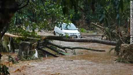
Torrential rains pummelled swathes of western Canada’s British Columbia and Washington state in the US in recent days – dumping a month’s worth of rain in two days in some areas – causing floods and mudslides that swallowed stretches of highways and forced the evacuation of thousands of people. One person has been killed and several have been reported missing.

Abbotsford, one of Canada’s most intensively and diversely farmed areas, was among places hardest hit. Home to more than 1,200 farms, it supplies half of the dairy, eggs and poultry consumed by British Columbia’s 5.2 million residents.

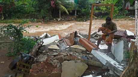
Aerial footage showed several barns engulfed by flood waters. Farmers and residents have been frantically scrambling to save their animals from rising waters, resorting to motorboats and jetskis to tow partly submerged cows one by one to higher ground.

Partially submerged barns in Abbotsford, British Columbia, one of Canada’s most intensively farmed areas. Photograph: Jonathan Hayward/AP

Many of the farms are in Sumas Prairie, a low-lying fertile stretch of land created by the draining of a lake nearly a century ago. An evacuation order on Tuesday included 121 dairy and poultry farms, according to farmers associations.

Local officials pleaded with about 300 people who defied the order. “If you are still on Sumas Prairie, you need to leave,” said Henry Braun, the mayor of Abbotsford. “I know it’s hard for farmers to leave their livestock, but people’s lives are more important to me right now than livestock or chickens.”

Lana Popham, minister of agriculture for British Columbia, said the storm had battered a key part of the province’s farmland, setting off an animal welfare crisis.

“There are probably hundreds of farms that have been affected by flooding. Some are still underwater, some are on dry locations and we have thousands of animals that have perished,” she said. “We have many, many more that are in difficult situations.”

map

Officials were racing to carve out routes in impassable areas to get veterinarians to stranded animals, she said. “There will have to be euthanizations that happen, but there are also animals that have survived that are going to be in critical need of food in the next 24 hours.”

Popham said she had spent the past two days on video calls with farmers affected. “Some of them are in their barns, and some of their barns are flooded and you can see the animals are deceased,” she said. “It’s heartbreaking.”

She said while some farmers had towed cows out of the flood waters, the rescued animals were “not in good shape” after their ordeal. “I can also tell you that many farmers attempted to move animals and then had to walk away because the roads were disappearing beneath them.”

In Abbotsford, Braun said it was too early to say how many animals had died. But a helicopter tour had given a dire picture of the storm’s impact. He said: “I saw barns that looked like they were half full of water. I can’t imagine that there are any birds left alive, but we don’t have those numbers.” In 2010, the area raised more than 9 million poultry birds.

Residents use jetskis to rescue their cows from flooding in British Columbia – video

Around 9,000 cows were housed at the 60 dairy farms affected by the Sumas Prairie evacuation order, said Holger Schwichtenberg, the chair of the BC Dairy Association.

As news of the order spread, he said dairy farmers had rallied together to stem the losses. “Countless farmers with trucks and trailers started hauling cattle out of the affected areas to farms like mine. We’re in a safe place, so we had 40 cows delivered to us.” He was unable to say how many cows had been moved to higher ground or how many had been left behind.

Farmers have been unable to get their milk to market, forcing some to dump thousands of litres. Schwichtenberg said: “The milk on our farm got dumped last night because there’s no way for the trucks to get here. The roads are impassable.”

The powerful storm comes less than six months after British Columbia was overwhelmed by record-high temperatures that killed more than 500 people and led to wildfires that gutted an entire town.

“We went through the heat dome and pretty much drought conditions all summer long and now we get the complete flipside,” he said.

Sign up for the Animals farmed monthly update to get a roundup of the biggest farming and food stories across the world and keep up with our investigations. You can send us your stories and thoughts at animalsfarmed@theguardian.com

Read original article here

Pacific north-west floods latest: record rainfall leaves at least one dead as Vancouver cut off | World news

The BC Government’s Alert Ready emergency system — which could have sent out a mobile alert to every cell phone in the region, as well as cut into radio and TV broadcasts with the evacuation alert — sat silent.

The government only uses it for tsunamis, so this “catastrophic” event did not qualify.

It was up to the City of Abbotsford to get the word out by itself, with its mayor and local emergency officials holding an impromptu press briefing late Tuesday night on the city’s YouTube channel — the makeshift event a far cry from the enormous reach of the provincial government’s largely quiet communications apparatus…

BC promised to expand the Alert Ready system after the summer’s heat dome killed 595 people, and the government found itself under fire for not doing enough to reach out to people before the emergency started to warn them to seek help in cooling centres.

But then the weekend flooding started, and instead of the broadcast system being ready for prime time it was scheduled to undergo a simple “test” message Wednesday (which was later cancelled after the real emergency started).

The province issued a statement late Tuesday night claiming it was “ready and available to issue a broadcast intrusive alert through the Alert Ready system” but that the “City of Abbotsford has indicated that it does not want to issue an alert at this time.”

Read original article here

Canada floods cut rail link to Vancouver port; one dead

MERRITT, British Columbia, Nov 16 (Reuters) – Floods and landslides that have killed at least one person have cut all rail access to Canada’s largest port in the city of Vancouver, a spokesperson for the port said on Tuesday.

Two days of torrential rain across the Pacific province of British Columbia touched off major flooding and shut rail routes operated by Canadian Pacific Rail (CP.TO) and Canadian National Railway (CNR.TO), Canada’s two biggest rail companies.

“All rail service coming to and from the Port of Vancouver is halted because of flooding in the British Columbia interior,” port spokesperson Matti Polychronis said.

At least one person was killed when a mudslide swept cars off Highway 99 near Pemberton, some 100 miles (160 km) to the northeast of Vancouver.

Two people were missing and search and rescue crews were combing through the rubble, officials said.

Vancouver’s port moves C$550 million ($440 million) worth of cargo a day, ranging from automobiles and finished goods to essential commodities.

The floods temporarily shut down much of the movement of wheat and canola from Canada, one of the world’s biggest grain exporters, during a busy time for trains to haul grain to the port following the harvest.

Drought has sharply reduced the size of Canada’s crops this year, meaning a rail disruption of a few days may not create a significant backlog, a grain industry source told Reuters.

Del Dosdall, senior export manager at grain handler Parrish & Heimbecker, said he expected some rail services could be restored by the weekend. Another industry source said he expected the shutdown to last weeks.

OIL PIPELINES SHUT DOWN

Floods have also hampered pipelines. Enbridge Inc (ENB.TO) shut a segment of a British Columbia natural gas pipeline as a precaution. read more

Crowds gather along the Trans-Canada highway to view flooding after rainstorms lashed the western Canadian province of British Columbia, triggering landslides and floods and shutting highways, in Abbotsford, British Columbia, Canada November 16, 2021. REUTERS/Jennifer Gauthier

Read More

The storms also forced the closure of the Trans Mountain pipeline, which carries up to 300,000 barrels per day of crude oil from Alberta province to the Pacific coast.

Copper and coal miner Teck Resources Limited (TECKb.TO) said the floods had disrupted movement of its commodities to its export terminals, while potash exporter Canpotex Ltd said it was looking for alternatives to move the crop nutrient overseas.

Directly to the south of British Columbia, in the U.S. state of Washington, heavy rain forced evacuations and cut off electricity for more than 150,000 households on Monday.

The U.S. National Weather Service on Tuesday issued a flash flood in Mount Vernon, Washington, “due to the potential for a levee failure.”

Some areas of British Columbia received 8 inches (20 cm) of rain on Sunday, the amount that usually falls in a month.

Authorities in Merritt, some 120 miles (200 km) northeast of Vancouver, ordered all 8,000 citizens to leave on Monday as river waters rose quickly, but some were still trapped in their homes on Tuesday, said city spokesman Greg Lowis.

Snow blanketed the town on Tuesday and some cars could be seen floating in the flood waters up to 4 feet (1.22 m) deep.

The towns of Chilliwack and Abbotsford ordered partial evacuations.

Abbotsford also issued an emergency warning on Tuesday night, asking all residents to evacuate the Sumas Prairie region immediately as deteriorating conditions posed a significant threat to lives.

Rescuers equipped with diggers and body-sniffing dogs started clearing mounds of debris that have choked highways.

The landslides and floods come less than six months after a wildfires gutted an entire town in British Columbia as temperatures soared during a record-breaking heat dome, raising new worries about climate change. read more

Reporting by Artur Gajda in Merritt and Rod Nickel in Winnipeg; additional reporting by David Ljunggren in Ottawa, Nia Williams in Calgary, Ismail Shakil in Bengaluru, Brad Brooks in Lubbock, Texas and Dan Whitcomb in Los Angeles, Maria Ponnezhath in Bengaluru; editing by Ed Osmond, Jonathan Oatis, Aurora Ellis and Sandra Maler

Our Standards: The Thomson Reuters Trust Principles.


Read original article here

Highway snaps in half, Vancouver cut off as province grapples with floods

British Columbia is grappling with the aftermath of intense rainfall and floods, which washed away parts of major highways and forced people to evacuate from affected locations in the southern part of the province.

Highway 1, 3, 7 and 5 in Coquihalla suffered extensive damage from river surges. Most of the highways remain closed, cutting off the Lower Mainland area completely.

The Coquihalla Highway, which appears to have snapped in two, is one of B.C.’s most important highways since it connects the city of Vancouver to the province Interior.

Reopening of the Coquihalla Highway could take months, Global News has reported.

“In some cases, it can be hours, or a day or two to remove debris,” Public Safety Minister and Deputy B.C. Premier Mike Farnworth said Tuesday morning.

“But in some cases, like the Coquihalla, it could be several weeks or months. We won’t know that until the experts do the work that needs to be done and they’re doing it right now.”

The Trans Canada Highway, known as Malahat or Highway 1, also remains closed due to severe impact. A section of the highway cut off and fell into the water near Tank Hill.

Highway 1 connects major Interior cities to one another and closures mean most of them have lost road access to neighbouring cities.

A section of the Trans Canada Highway

On top of this, all rail access to the Port of Vancouver, Canada’s largest port has been cut off. 

“All rail service coming to and from the Port of Vancouver is halted because of flooding in the British Columbia interior,” port spokesperson Matti Polychronis said.

Vancouver’s port moves C$550 million ($440 million) worth of cargo each day, so the economic impact of the rail halt could be substantial, Reuters reported.

Officials rescued 275 people who were stranded in between various mudslides by using helicopters since most of the roads were closed.

Abbotsford and Chilliwack, B.C. authorities have expanded evacuation orders and are asking residents to leave immediately.

“This is changing so quickly that you might think you’re OK one minute and literally half an hour later you’ll see the change in the water levels,” said Abbotsford Police Chief Mike Serr.

But due to the highway closures and limited hotel availability, officials have asked evacuees to stay with family and friends, according to CBC News.

Officials are also rescuing those stranded in remote homes in the province using boats since there’s no road access.

Public Safety Minister Mike Farnworth said conditions remain in flux throughout the province.

“I would like to thank everyone who is affected for your patience, strength and for doing everything you can to stay safe,” he said.

Read original article here

At least one dead, Vancouver port closed in Canada floods | Floods News

Heavy rain has prompted evacuations in British Columbia and caused power outages in the US state of Washington.

At least one person has been killed as torrential rains triggered landslides and floods in western Canada, forcing the closure of the country’s busiest port in Vancouver.

Canada’s federal police force, the Royal Canadian Mounted Police (RCMP), confirmed on Tuesday that at least one woman died after mudslides blocked a major highway in the province of British Columbia. The flooding has also closed several highways in and around the greater Vancouver area, a major coastal city that is home to nearly 2.5 million people.

CBC, Canada’s public broadcaster, cited RCMP official Janelle Shoihet as saying that authorities have received reports of two more people missing.

Port authorities announced on Tuesday that they had suspended rail routes operated by Canada’s two largest rail companies – Canadian Pacific Rail and Canadian National Railway – because of the floods.

“All rail service coming to and from the Port of Vancouver is halted because of flooding in the British Columbia interior,” said port spokesperson Matti Polychronis.

Vancouver’s port moves 550 million Canadian dollars ($440m) worth of cargo every day, including grain, coal, cars and essential goods.

The storms temporarily stopped much of the movement of wheat and canola from Canada, one of the world’s biggest grain producers. It is not clear how long it will be before rail access to the port is restored.

Nearly 300 people trapped by mudslides were rescued by helicopters in British Columbia late on Monday.

“Trapped between two slides are approximately 275 additional people, including 50 children, who were advised to shelter in place overnight as debris was unstable and unsafe to cross,” the City of Vancouver and Canada Task Force 1 said in a joint statement.

Earlier on Monday, authorities in Merritt, some 200km (124 miles) northeast of Vancouver, ordered all 7,100 citizens to leave after rising waters cut off bridges and forced the wastewater treatment plant to close.

The towns of Chilliwack and Abbotsford, east of Vancouver, also ordered partial evacuations on Tuesday.

Some areas received 200mm (8 inches) of rain on Sunday – the amount they usually see in a month – and the deluge continued on Monday, with roads covered by mud or up to 250mm (10 inches) of water.

In the United States, thousands experienced power outages because of the heavy rain in Washington state, just south of British Columbia. Nearly 50,000 customers remained with no power on Tuesday; as many as 158,000 customers had lost power at the height of the storm on Monday in the state.

One person in the small town of Everson, north of Seattle, has gone missing after being swept away by floodwaters.

British Columbia and the US northwest have been frequently experiencing extreme weather events that experts partly blame on global warming. The region saw large wildfires and record temperatures over the summer in a heatwave that killed hundreds of people.


Read original article here

‘A tipping point’: how poor forestry fuels floods and fires in western Canada | Canada

A devastating string of floods and landslides have shocked residents in British Columbia, a west Canadian province increasingly forced to grapple with the effects of the climate crisis. As images of the devastation circulate on social media, experts warn that management of the province’s forests will be critical to blunting the effects of future storms.

“It’s just this awful feeling of being right – and not wanting to be right. This is exactly what the best available science has predicted for years,” said Peter Wood, author of a recent report on the link between clearcut logging and community safety from the Sierra Club BC. “We know the outcome when you log steep slopes … You reach sort of a tipping point, where the forest is no longer able to provide that moderating service of controlling flow of water.”

On Tuesday, more residents were forced to flee their homes amid intermittent landslides and rising water levels. Videos from aerial flyovers showed parts of Abbotsford inundated with flood waters. Further north, a section of the Coquihalla highway, one of the province’s main road systems, appeared to have been severed. Officials say it could be months before the highway can safely reopen.

Officials said it could be months before one of the province’s busiest highways reopens, after sections were destroyed. Rescue teams also began the search for people whose cars may have been buried after a series of mudslides trapped vehicles travelling east of Vancouver.

Search and rescue personnel help flood evacuees disembark from a helicopter in Agassiz, British Columbia, on Monday. Photograph: Jonathan Hayward/AP

Experts have long cautioned that clearcut logging affects slope stability, the rate at which water is absorbed into the ground and the ability to hold soil in root systems. Without trees, heavy rains can wash large amounts of sediment into nearby water systems, choking creeks and streams and causing them to quickly overflow.

“Over the last couple days, I’ve been looking at the areas that have been particularly hard hit, and it happens to coincide with some of the communities that have been logged the heaviest,” said Wood. “A lot of that is due to the mountain pine beetle, but nonetheless, the cutting really does affect the amount of water that flows overland.”

At the same time, British Columbia has suffered some of its worst wildfire seasons in recent years. As the aftermath of the storm became clear, a number of the areas worst hit were also near blazes that tore through the province earlier in the summer.

Smoke rising from fire at McKay Creek is seen from Lillooet, British Columbia, in June. Photograph: Sid Bones-Scotchman/Reuters

“There’s a very clear link between a wildfire happening and the risk of a landslide or debris flow,” said Thomas Martin, a forester in the province. “If you burn a lot of the trees, grass and shrubs, there are fewer living things to intercept the water. It just flows directly off the hill. And fires can make the soil hydrophobic so the runoff increases even more.”

The problem for the province isn’t just that fires are getting larger – they’re also getting more severe and are burning at higher temperatures.

Martin says forest ecologists have long recommended controlled burns as well as selective logging to thin the forests, allowing larger mature trees to thrive and improving protection against wildfires.

“But there does not seem to be a political will to do what is required. We’re talking about a large-scale look at the landscape, and how can we adapt our forests to climate change.”

While forest fires have long been seen as a summer event, the recent flooding has highlighted how interconnected the issues are.

“You have all these indirect effects on the landscape. Landslides have now taken out two major highways. The entire town of Merritt has been flooded, lost its drinking water and been evacuated,” he said. “Would I have predicted that both our key highways would get absolutely destroyed in this event? No. But was I surprised that it seems like both of these watershed events occurred in wildfires? No.”


Read original article here

Frustration, defiance in village to be abandoned to the sea

FAIRBOURNE, Wales (AP) — Like many others who came to Fairbourne, Stuart Eves decided the coastal village in northern Wales would be home for life when he moved here 26 years ago. He fell in love with the peaceful, slow pace of small village life in this community of about 700 residents, nestled between the rugged mountains and the Irish Sea.

“I wanted somewhere my children can have the same upbringing as I had, so they can run free,” said Eves, 72, who built a caravan park in the village that he still runs with his son. “You’ve got the sea, you’ve got the mountains. It’s just a stunning place to live.”

That changed suddenly in 2014, when authorities identified Fairbourne as the first coastal community in the U.K. to be at high risk of flooding due to climate change.

Predicting faster sea level rises and more frequent and extreme storms due to global warming, the government said it could only afford to keep defending the village for another 40 years. Officials said that by 2054, it would no longer be safe or sustainable to live in Fairbourne.

Authorities have been working with villagers on the process of so-called “managed realignment” — essentially, to move them away and abandon the village to the encroaching sea.

Overnight, house prices in Fairbourne nosedived. Residents were dubbed the U.K.’s first “climate refugees.” Many were left shocked and angry by national headlines declaring their whole village would be “decommissioned.” Seven years on, most of their questions about their future remain unanswered.

“They’ve doomed the village, and now they’ve got to try to rehome the people. That’s 450 houses,” said Eves, who serves as chair of the local community council. “If they want us out by 2054, then they’ve got to have the accommodation to put us in.”

No one here wants to leave. While many are retirees, there are also young families raising a next generation. Locals speak proudly of their tight-knit community. And although the village center only consists of a grocer’s, a fish and chip shop and a couple of restaurants, residents say the pebbly beach and a small steam train draw bustling crowds in the summer.

Natural Resources Wales, the government-sponsored organization responsible for the sea defenses in Fairbourne, said the village is particularly vulnerable because it faces multiple flooding risks. Built in the 1850s on a low-lying saltmarsh, Fairbourne already lies beneath sea level at high spring tide. During storms, the tidal level is more than 1.5 meters (5 feet) above the level of the village.

Scientists say U.K. sea levels have risen about 10 centimeters (4 inches) in the past century. Depending on greenhouse gas emissions and actions that governments take, the predicted rise is 70 centimeters to 1 meter by 2100.

Fairbourne is also at the mouth of an estuary, with additional risks of flash floods from the river running behind it. Officials have spent millions of pounds in strengthening a sea wall and almost 2 miles of tidal defenses.

While there are flood risks in many other villages along the Welsh coast, decisions on which areas to protect ultimately boil down to cost. Officials say that in the case of Fairbourne, the cost of maintaining flood defenses will become higher than “the value of what we’re protecting.”

The effects of climate change that negotiators at the United Nations climate summit in Glasgow, Scotland, are working to mitigate already are a reality here.

Catrin Wager, a cabinet member of Gwynedd Council, the local authority overseeing Fairbourne, stressed that while Fairbourne may be the first Welsh coastal village to be designated unviable due to climate change, it certainly won’t be the only one. There’s no precedent for how to develop policies for helping the villagers adapt, she said.

“We need more answers from the Welsh and U.K. governments, that’s my message going into this (U.N. summit),” Wager said. “We really need to get some guidance on not only mitigating the effects of climate change, but about how we adapt for things that are already happening.”

Across the U.K., half a million properties are at risk of coastal flooding — and that risk figure will jump to 1.5 million by the end of the 2080s, according to the Climate Change Committee, an independent advisory body set up under climate change laws.

Britain’s government, which is hosting the U.N. climate summit, needs to be much more upfront about such risks, said Richard Dawson, a member of the committee and professor of engineering at Newcastle University.

Ultimately, “difficult decisions” need to be made about many coastal settlements with disproportionately high numbers of older and poorer residents, he said, and officials need to prepare people for moving inland.

“Whatever happens at COP the sea level will continue to rise around the U.K., that’s something we absolutely need to prepare for,” Dawson said. “We have to be realistic. We can’t afford to protect everywhere. The challenge for government is that the problem is not being confronted with the urgency or openness that we need.”

In Fairbourne, a continuing standoff between villagers and officials underlines that challenge. Residents feel they have been unfairly singled out, and aren’t convinced there is a clear timeframe on how quickly sea levels will rise enough to threaten their homes. When and how will evacuation take place? Will they be compensated, and if so how much should it be?

There are no answers. The village vicar, Ruth Hansford, said many residents suffered “emotional fatigue” from years of uncertainty and negativity. Others simply decided to carry on with their lives.

Becky Offland and her husband recently took on the lease of the Glan Y Mor Hotel, going against the grain and investing in the village’s future. They’re hopeful their business will bring more visitors and financial support to Fairbourne.

“It’s like a big family, this place. It’s not a village, it’s a family,” said Offland, 36. “We’ll all fight to keep it where it is.”

Down the street, Fairbourne Chippy owner Alan Jones, 64, also said he has no plans to go anywhere.

“Until water actually comes in here, ’til we physically can’t work, we’ll carry on,” he said.

Eves said he and his son believe that “what will be, will be.” But he will mourn the inevitable disintegration of the village he loves.

“You can’t sort of take this village here, and put it over there and expect it to work again,” he said. “What you have here is a human catastrophe, albeit on a small scale.”

___

Read stories on climate issues by The Associated Press at https://apnews.com/hub/climate

Read original article here

Catania, Sicily floods: ‘Medicane’ tears through southern Italy, with more rain expected

Sicily’s President Nello Musumeci confirmed the deaths and said a third person was missing late on Tuesday, while the mayor of the city Catania urged residents to stay home if possible.

“We have been through two very difficult days. We have lived through dramatic hours,” mayor Salvo Pogliese said in a video posted to his Facebook page. He said the weather was “definitely better” on Wednesday, but warned the forecast for Thursday and Friday remained “particularly worrying.”

Red warnings have been issued for Wednesday and Thursday on the island of Sicily and the region containing the city of Catania, which has already been pummeled by adverse weather throughout the week.

The storm comes as global leaders prepare to gather in Rome, Italy’s capital, for a G20 summit. Climate concerns are high on the agenda at the event, which will be immediately followed by a critical COP26 meeting in Scotland.

The medicane — a hurricane-like storm system that formed over the Mediterranean Sea — has dumped one year’s worth of rain on the Linguaglossa region in the space of two days, according to climatological data in the nearby city of Catania.

The storm is forecast to linger around the area until the weekend, with more rain expected. Schools and non-essential shops and offices are ordered to stay closed until Friday in Catania.

Over 600 rescue operations have been carried out in Catania in the past day, the interior ministry said Wednesday in a press release.

“The event is not over. Now there is a moment of attenuation, but our weather models tell us it will be back. Complicated hours await us in this area. We expect a significant worsening from Thursday to Friday,” the head of civil protection Fabrizio Curcio said at a press conference in Catania.

Regional governor Nello Mosumeci described the situation as “very critical” and described the scenes seen across Catania and its province as “atrocious.”

“Roads have been turned into streams” and “countryside into lakes, entire isolated districts and hundreds of flooded houses, incalculable damage to buildings and crops: Eastern Sicily is experiencing a phenomenon that we fear, unfortunately, will be less and less sporadic, with tragic scenarios destined to repeat itself,” he said Tuesday on his official Facebook page.

Medicanes occur around twice a year, usually between September and December.

This system is not expected to threaten the G20 talks in Rome, but adds further urgency to the ongoing effort of several countries to commit the world to tougher climate change targets.

Science shows that human-made climate change is making extreme weather events, including heavy rainfall, more frequent and intense. The climate crisis is also contributing to swings between drought and floods in many places, including parts of the United States, like California, as well as the Middle East and Africa.

As the Earth’s atmosphere gets warmer, it can hold more moisture, which is why the world is experiencing heavier bursts of rain that it historically has. But the climate crisis is also creating longer dry spells, or drought, which leaves land and soil so dry that it can’t absorb the rain as effectively as usual. This combination makes flooding more likely, and often more destructive.

Read original article here

Floods and landslides kill at least 150 in India and Nepal

According to Nepal’s Home Ministry, 77 people died this week from floods and landslides, after heavy rainfall that began on Monday. Some 22 people were injured, and 26 are missing.

The flooding mainly took place in regions across Western Nepal, close to the neighboring northern Indian state of Uttarakhand.

At least 46 people have died in Uttarakhand and 27 bodies were recovered in the southern Indian state of Kerala, according to officials from both states.

Both states began receiving heavy rainfall over the weekend, resulting in landslides, bridges and houses collapsing, and rivers overflowing. Aerial footage of the affected areas showed villages partially submerged by floodwaters.

“There is huge loss due to the floods … the crops have been destroyed,” Uttarakhand’s chief minister, Pushkar Singh Dhami, told Reuters partner ANI after surveying the damage late on Tuesday.

“The locals are facing a lot of problems, the roads are waterlogged, bridges have been washed away.”

In Uttarakhand, Nainital district was the worst affected area with the most deaths, according to senior police official Ashok Kumar. At least 3,000 people had to be evacuated from a barge on the Sarda River, which overflowed on Monday, he said.

The flooding comes in the middle of a religious pilgrimage called the Chardham Yatra, during which Hindus from around India make the journey to Uttarakhand.

Up to 100 pilgrims from the western state of Gujarat were visiting Uttarakhand when the floods arrived, according to Gujarat’s disaster management minister Rajendra Trivedi.

Six of those pilgrims became trapped in the upper reaches of Kedarnath, one of the main religious sites. A helicopter was sent to evacuate the pilgrims, but poor weather conditions frustrated rescue efforts, Trivedi said on Tuesday. By Wednesday, water levels had receded enough for the pilgrims and residents to find safe shelter.

The pilgrimage has been temporarily suspended, and will resume once rainfall recedes.

Two observatories in the Kumaun region of the state, where Nainital is located, recorded 340.8 millimeters (13.4 inches) of rainfall and 403.2 millimeters (15.8 inches) respectively, marking the highest rainfall over a 24-hour period ever recorded in the region, the Indian Meteorological Department said Tuesday.

The Himalayan state is especially prone to flooding. More than 200 were feared killed in February after flash floods swept away a hydroelectric dam.

Meanwhile in Kerala, more than 200 families are currently in 26 evacuation camps across the state. With heavy rainfall forecast to continue in the coming days, state authorities are urging residents to stay indoors.

Additional reporting by Reuters.

Read original article here

Kerala floods: At least 22 people killed after torrential rain triggers landslides and floods

Torrential rain has battered the coastal state of Kerala since Friday, causing rivers to swell and flooding roads that left vehicles submerged in muddy waters, with some houses reduced to rubble.

Rescue efforts have continued since Saturday, with the Indian army, navy and air force assisting. The National Disaster Response Force has deployed 11 teams across south and central parts of Kerala.

Thirteen people were killed in a landslide in the Kottayam district, according to state officials. Nine bodies have also been recovered from the site of another landslide in the district of Idduki, officials said, adding that two people are still unaccounted for. Three fishermen in the Malappuram district also remain missing.

At least 6,455 people have been evacuated to 184 relief camps across the state, according to the Kerala State Disaster Management Authority.

The heavy rainfall was caused by a low pressure area over the southeastern Arabian sea and Kerala, India’s Meteorological Department said. The deluge was forecast to ease Monday, but CNN Weather still predicts 50 to 100 millimeters (2 to 4 inches) of rain for the area in the coming days.

Home to more than 33 million people, Kerala regularly experiences heavy rainfall during the monsoon months from late May to September. However, flash flooding and landslides have become more frequent and severe in the state in recent years.

In August 2018, at least 324 people were killed and more than 300,000 evacuated after torrential rain battered Kerala, resulting in the worst flooding the state had seen in nearly a century. Some 13 of Kerala’s 14 districts were under a red alert, the highest warning level issued during emergencies in India.

Read original article here