Florida is in for a week of impactful weather regardless of how developing low pressure evolves north of the Greater Antilles.
That low, spurred by a deep dip in the jet stream, is not of pure tropical origin. But it has already caused flooding and damaging landslides in Puerto Rico, and even fatalities in the Dominican Republic when 9 inches of rain fell in just a few hours on Friday evening in the capital city of Santo Domingo.
The National Hurricane Center will likely label the system as a Potential Tropical Cyclone, and both Broward and Miami-Dade could end up inside a “cone of concern” sooner than later.
While it’s likely that the low will, at worst, be a subtropical or tropical storm, there are one or two models that are forecasting a November hurricane for South Florida.
November is the last month of hurricane season and, typically, tropical activity starts to wind down. 2022’s Hurricane Season has been backloaded, however, and almost all of the impactful storms in the Atlantic this year formed after August.
The State of Florida has been hit nine times by tropical systems this month over the last 170+ years—about a 5 percent chance in any one year.
Seven of those nine came up from the western Caribbean and the Gulf of Mexico. That makes this week’s developing system, should it consolidate and hit Florida, quite rare.
But what’s exceptionally rare is for the Florida peninsula to get hit by a hurricane, regardless of where it originated, in the month of November.
There is only one hurricane on record that hit the peninsula in November, dating back to 1851—the so-called Yankee Hurricane which struck Miami Beach (near present-day Bal Harbour) on November 4th, 1935. It was a Category 2!
For now, the forecast calls for the frequency and intensity of rain showers to increase as we head into midweek. It will become increasingly windy, with hazardous marine conditions and a high risk of rip currents.
Winds and waves will combine with a full moon and sea level rise worsened by climate change to produce significant coastal flooding.
Communities such as Fort Lauderdale, Miami Beach, Miami Shores, and neighborhoods near Biscayne Boulevard including Edgewater, Coconut Grove, Coral Gables, and the Florida Keys, need to brace for potentially the worst saltwater inundation of the year.
The closest point of approach of the center of the system to Ft Lauderdale and Miami is expected to be Wednesday into early Thursday. But it is too soon to tell what form the system will eventually take—low pressure, a subtropical storm, tropical storm, or hurricane.
Obviously, no one wants to deal with a hurricane any time of year, much less now that holiday music is playing on the radio.
Decades ago, I might have been pretty dismissive of such a low-probability event. But I’m seeing way too many extreme weather events driven by global warming lately to discount yet another near-unprecedented event.
Ahead of potentially icy conditions on the tri-state area roads Sunday, New Jersey and Pennsylvania have started implementing vehicle and speed restrictions.
The NBC10 First Alert Weather Team has issued a First Alert from 7 a.m. to 1 p.m. for the Pennsylvania suburbs, Berks County and the Lehigh Valley as light but steady freezing rain falls through the morning.
Both the Pennsylvania Department of Transportation (PennDOT) and the New Jersey Department of Transportation (NJDOT) have issued several speed and vehicle restrictions that go into effect Saturday night.
The following commercial vehicle travel restriction are set to go in effect in New Jersey starting at 2 a.m.:
I-78, entire length from the Pennsylvania border to I-95 (New Jersey Turnpike)
I-80, entire length from the Pennsylvania border to I-95 (New Jersey Turnpike)
I-280, entire length from I-80 to I-95 (New Jersey Turnpike)
I-287, entire length from NJ Route 440 to the New York State border
NJ Route 440, from the Outerbridge Crossing to I-287
The commercial vehicle travel restriction applies to:
All tractor trailers (exceptions as listed in the Administrative Order)
Empty straight CDL-weighted trucks
Passenger vehicles pulling trailers
Recreational vehicles
Motorcycles
This restriction DOES NOT apply to:
The New Jersey Turnpike
The Garden State Parkway
The Atlantic City Expressway
Public safety vehicles, sworn and civilian public safety personnel; as well as other personnel directly supporting healthcare facilities or critical infrastructure such as providing fuel or food. For a complete list of operations or personnel that are exempt from the travel ban, see the Administrative Order.
The following restrictions are in effect in Pennsylvania:
Effective at 10:00 PM, vehicle restrictions are planned for the following roadways at Tier 1 of the commonwealth’s weather event vehicle restriction plan:
Interstate 70 from the PA Turnpike to the West Virginia border; and
The entire length of I-79.
Effective at 11:00 PM, a Tier 4 restriction is planned on the PA Turnpike I-76 (Mainline) in both directions from Cranberry (Exit 28) to Breezewood (Exit 161).
Effective at midnight, Tier 3 and Tier 4 restrictions are planned for the following roadways:
I-70 from the Maryland border to the PA Turnpike (Tier 3);
The entire length of I-99 (Tier 4); and
I-80 from I-79 to I-81 (Tier 4).
Effective at 2:00 AM, Tier 3 and Tier 4 restrictions are planned for the following roadways:
Tier 3
The entire length of I-83;
The entire length of I-84;
The entire length of I-176;
U.S. 22 from I-78 to the New Jersey border; and
U.S. 33 from I-80 to I-78.
Tier 4
The entire length of I-78;
The entire length of I-81;
The entire length of I-180;
The entire length of I-380;
I-80 from I-81 to the New Jersey border; and
PA Turnpike I-76 (Mainline) in both directions from Breezewood (Exit 161) to Reading (Exit 286).
Effective at 5:00 AM Tier 4 restrictions are planned on the PA Turnpike I-76 (Mainline) in both directions from Reading (Exit 286) to Bensalem (Exit 351) as well as the full length of I-476 (Northeastern Extension) in both directions
Under Tier 1 restrictions, the following vehicles are not permitted on affected roadways:
Tractors without trailers;
Tractors towing unloaded or lightly loaded enclosed trailers, open trailers or tank trailers;
Tractors towing unloaded or lightly loaded tandem trailers;
Enclosed cargo delivery trucks that meet the definition of a CMV;
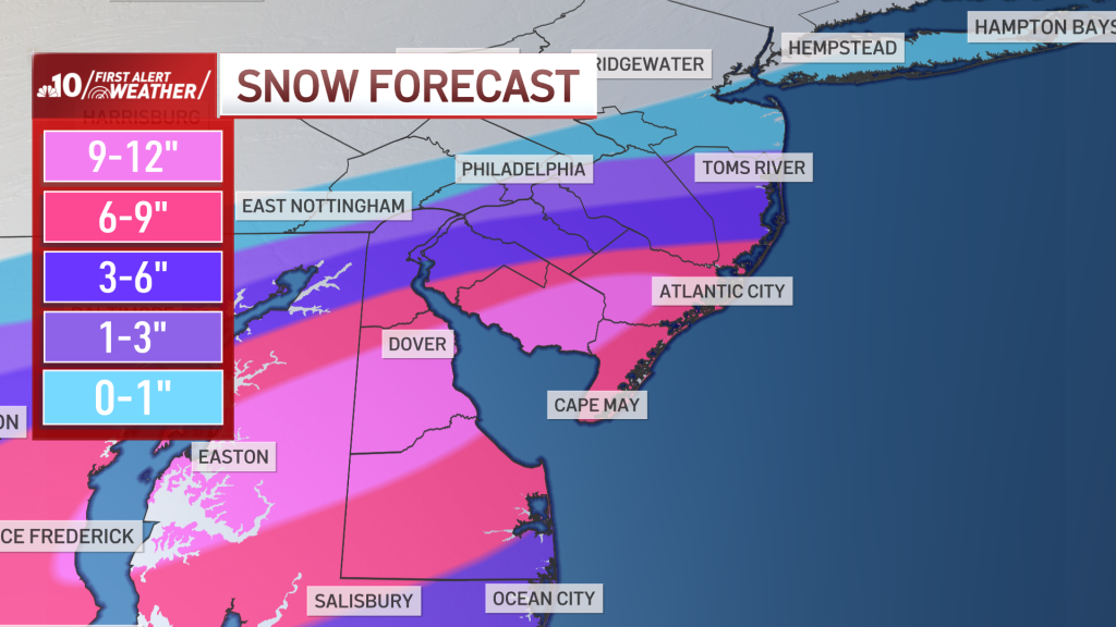
Snow, heavy at times, will fall on parts of the Philadelphia region Monday.
Some neighborhoods in New Jersey and Delaware could get around a foot of snow, while parts of the Pennsylvania suburbs and Lehigh Valley could get very little accumulation.
A First Alert is in effect through 5 p.m. Monday for Philadelphia and points south.
Is school open? More than 100 schools are closed. Get the school closings here.
The first winter storm of the season is impacting the southern half of the Philadelphia viewing area Monday. This storm has the potential to deliver the biggest snowfall in years for parts of southern New Jersey, central and southern Delaware and Jersey Shore points. Some places could even get a foot of snow. Neighborhoods to the north could get next to now snow on the ground.
What’s the Timing of the Snow?
The NBC10 First Alert Weather team has issued a First Alert until 5 p.m. Monday for Philadelphia, Delaware, South Jersey and the Jersey Shore due to the chance of at-times heavy snow and a moderate threat of coastal flooding. The snow in some neighborhoods could last until early evening.
NBC10
The First Alert is for snow in Philadelphia, South Jersey and Delaware on Monday.
Rain or rain mixed with snow started before daybreak across far southern New Jersey and Delaware. By 5:30 a.m., icy snow began to fall on the Atlantic City Boardwalk.
As the storm system lifts north and intensifies, heavier bands of rain and snow mix will rapidly change to heavy wet snow. Several very heavy snow bands with snowfall rates of 1″+/hour are likely across South Jersey, central and southern Delaware and the shore points. The intensity of the snow will allow it to quickly accumulate during the morning and into the afternoon hours.
WATCH LIVE: See the snowflakes fall with our Atlantic City Boardwalk Snow Cam.
Radar could show snow that isn’t reaching the ground in some neighborhoods.
Be careful driving on roads as slick spots should be expected, even in spots where a lot of snow doesn’t fall.
How Much Snow Is Expected to Fall?
Central and western areas of South Jersey are likely to receive 1 to 6 inches of snow. Widespread snow totals of 6 inches or more are expected as you move to more southern parts of South Jersey, central and southern Delaware and the shore.
Some places just west of the Garden State Parkway may exceed 9 inches of snow and get up to a foot of snow or more. Snow may mix with rain along the immediate coast along (barrier islands), so snow totals should stay in the 6 to 9 inch range. Driving conditions will be extremely poor and people should just stay home and work from home if they can.
NBC10
Some areas could get a foot of snow Monday. Others won’t get much.
Closer to Philadelphia, the storm will be far less impressive. The snowfall amounts will RAPIDLY drop off and snowfall of 1 to 3 inches at best are expected.
It’s conceivable with warm ground and lighter snow rates, nothing sticks on Philadelphia roads for much of the storm. Briefly through the morning, with a few steadier snow bands, some messy or slushy conditions are possible around Philadelphia. That range of 1 to 3 inches is expected along much of the I-95 Corridor. However, around Wilmington, Delaware, the totals will fall on the high end of the range. The range of 3 to 6 inches will sit just south of Wilmington in New Castle County.
Snowfall totals will rapidly increase as you head east of the I-295 corridor. While neighborhoods near and north of Philadelphia will only see 1 inch or less, 25 miles southeast of the city look to receive widespread totals of 6 inches or more. That’s how sharp the gradient will be.
See It, Share It: You can send photos and video of the snow in your neighborhood by clicking this link.
Where Will Wind and Flooding Be a Concern?
In addition to the snow, strong wind gusts of 30 to 45 mph are possible late Monday morning through early Monday evening across Delaware and New Jersey and at the shore. The strongest gusts will be felt right along the coast during the afternoon.
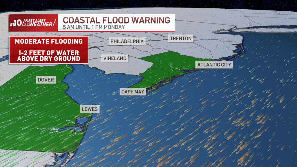
A Coastal Flood Warning is in effect for tidal areas in Atlantic and Cape May counties in New Jersey and Sussex County in Delaware until 1 p.m. Monday for the high tide cycle.
Moderate coastal flooding is possible in coastal Atlantic, Cape May, Kent, and Sussex counties. This means salt water may be 1 to 2 feet above dry ground in vulnerable areas.
A Winter Storm Warning is in effect for central and southern Delaware as well as South Jersey until at least 4 p.m. Monday.
State of Emergency in New Jersey
Ahead of the storm, New Jersey Gov. Phil Murphy announced he would issue a state of emergency Sunday night for Ocean, Cumberland, Cape May, Burlington and Atlantic counties.
“Residents should stay off the roads, remain vigilant, and follow all safety protocols,” the Democratic governor said.
NBC10’s Randy Gyllenhaal reports as snow falls on the Atlantic City Boardwalk Monday morning.
Once the Snow Leaves, Cold Sticks Around at Night
The worst of the storm is over before 5 p.m. After that it gets very cold with lows in the teens Monday night. As a result, icy conditions are expected on roads and sidewalks that are left snowy or wet.
Tuesday and Thursday look quiet and chilly. Wednesday is milder with a few showers. Friday we have the potential for another winter storm, but details are extremely uncertain this far out.
The forecast shifted dramatically from 24 hours ago, due to the track of this storm. It may yet shift again. To stay aware of the changes and receive important weather alerts, make sure to download the free NBC10 app and watch our meteorologists’ forecasts on all platforms.
Monday: Heavy snow parts of NJ & Del. Light snow in City. Mainly dry suburbs & Lehigh Valley. High 34 Tuesday: Mostly sunny. High 36 Wednesday: Mostly cloudy. Chance of a shower. High 44 Thursday: Partly sunny. High 40 Friday: Snow or a wintry mix possible. High 34
A drastic weather change is in store for the greater Philadelphia region, with a winter storm possibly dumping snow in some neighborhoods Monday morning.
The NBC10 First Alert Weather team has issued a First Alert between 4 a.m. and 4 p.m. Monday for Philadelphia, Delaware, South Jersey and the Jersey Shore due to the chance of at-times heavy snow and a moderate threat of coastal flooding.
Neighborhoods north of Philadelphia could get about an inch of snow or less, Philadelphia is expected to get 1-2 inches, parts of South Jersey and central Delaware could get 2-6 inches and southern Delaware through to coastal New Jersey neighborhoods could get 6 or more inches.
NBC10
A winter storm is expected to dump snow over the region Monday.
This storm has been evolving rapidly, and the snow totals forecast will need to be adjusted. Some areas south could end up with higher totals, and a sharp cutoff to little or no snow is expected near the I-95 corridor. These details will be fine-tuned through Sunday afternoon.
Warm roads from Sunday’s 60-degree temperatures will allow for the initial overnight snow to melt, but as intensity picks up Monday morning, accumulation is expected to begin over the southern half of the region. The heaviest snow is expected to fall in the morning, so commuters need to be extra careful on the roads to avoid crashes, or they should work from home if possible to avoid potentially dangerous conditions.
While temperatures have been above normal over the last week, people should also prepare for a 30-degree drop by Monday morning, with highs reaching the low-30 degrees. In addition, winds gusting between 25-30 mph will make things feel like the teens and 20s.
The forecast shifted dramatically from 24 hours ago, due to the track of this storm. It may yet shift again. To stay aware of the changes and receive important weather alerts, make sure to download the free NBC10 app and watch our meteorologists’ forecasts on all platforms.
The modern tornado record goes back to 1950. Until Saturday, a tornado had never been recorded in Connecticut during the months of November or December.
Saturday’s severe weather event featured a powerful line of thunderstorms that produced small hail and strong winds. This line also produced at least three brief tornadoes in Connecticut and several more on Long Island.
Advances in radar technology allow us to not only see the wind speed and direction in a storm (which is useful for picking out areas of rotation) but also whether the radar is picking up rain drops or other targets.
In Saturday’s case, there were three instances of lofted tornado debris in Connecticut known as a Tornado Debris Signature or TDS, which we were able to detect in real time.
WATCH: Greg St. Martin captured this video moments before trees in his backyard fell over in Cheshire. Small picture of what some people experienced as strong winds and rain barreled through the state. @NBCConnecticut pic.twitter.com/kDDTFrjwOr
— Dominique Moody (@dmoodytv) November 14, 2021
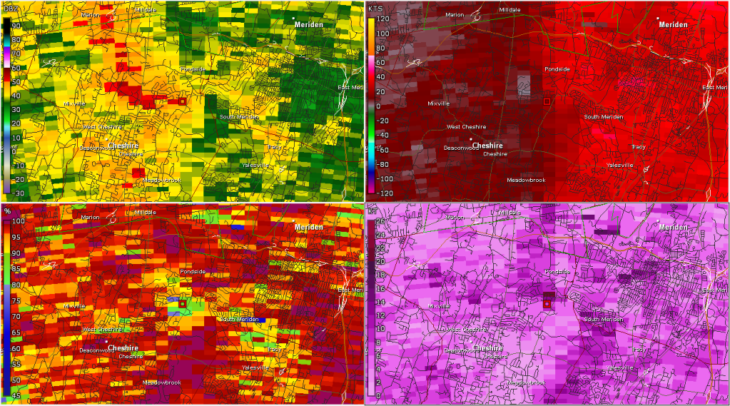
The first TDS occurred in Cheshire at 3:31 p.m. just west of downtown. There is a fairly widespread area of damage in this part of town.
This 4 panel radar plot shows precipitation intensity (upper level), radial wind velocity (upper right), spectrum width (lower right), and correlation coefficient (lower left) at 3:31 p.m.. Winds over 60 mph were sampled by the radar along with a robust circulation, but at this time no tornado debris is being detected.
Six minutes later, the rotation has weakened, but the plot in the lower left shows a lowering of correlation coefficient which indicates lofted tornado debris (likely many leaves).
Some residents are cleaning up after trees fell down in and on their properties, as well as on local streets.
At 3:45 p.m., the southern portion of the line that had been exhibiting rotation over Long Island Sound moved inland over Branford and likely resulted in a tornado touch down in the Pine Orchard section of town. Lofted tornado debris was detected into portions of Guilford with sporadic damage reports as far northeast at Cornwall Rd in the Guilford Lakes section of town.
The clean up is continuing on Sunday after strong storms moved through Saturday and caused damage across the state.
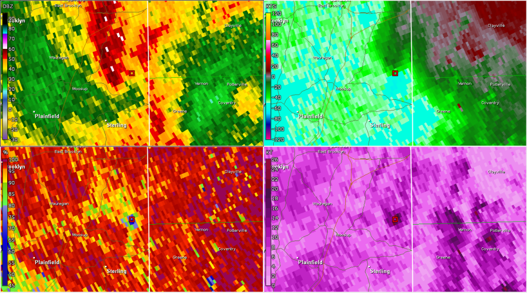
A third tornado appears to have touched down in northeastern Connecticut. It started in Griswold and continued into Plainfield, Sterling, and Rhode Island. The Tornado Debris Signature was quite clear from the weather radar in Boston and there are several reports of damage.
4:55 p.m. radar grab showing the strong rotation in the upper right and lofted tornado debris in the lower left over Sterling.
Saturday’s tornado event was well forecast. On Friday, we mentioned severe weather was possible and by Saturday morning, our forecast was more certain and included the risk for tornadoes given the strong low level wind shear and an adequate amount of instability.
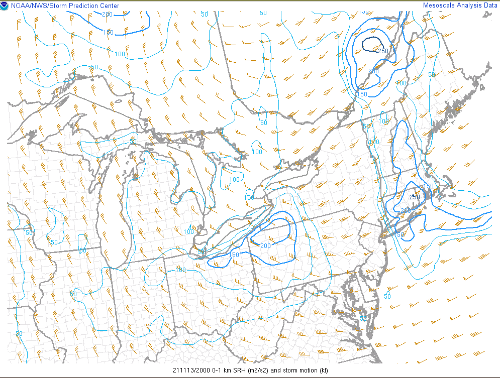
SPC Mesoanalysis shows very strong low level wind shear over CT which is favorable for rotating storms.
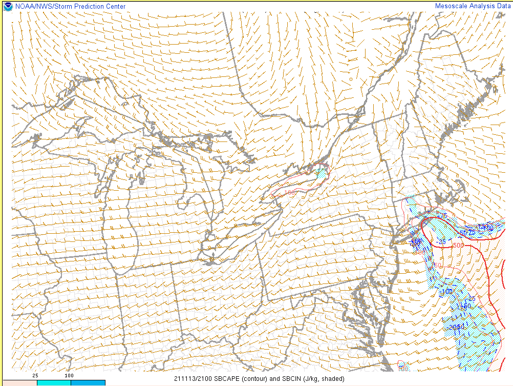
SPC mesoanalysis shows a small, but adequate, amount of instability. Instability is a requisite for thunderstorms to form.
While radar confirmed three tornado touchdowns Saturday in Connecticut, the National Weather Service will make the final determination about the intensity and path of each storm.
This was certainly a November severe weather event to remember. Thankfully, there are no reports of injuries and few reports of structural damage.