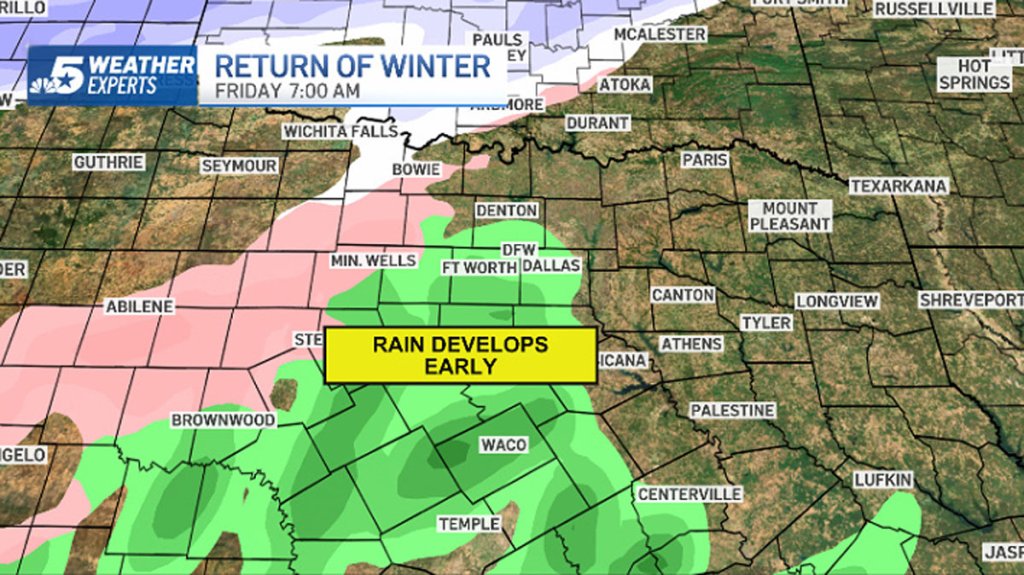
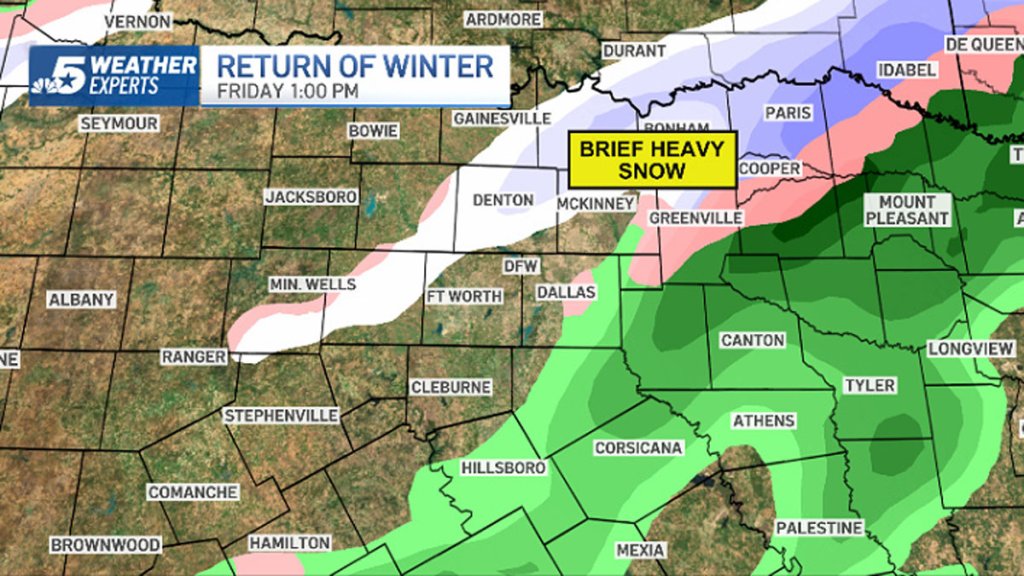
Rain develops around sunrise, changing to sleet-snow mix by mid-morning.
Bridges and overpasses will become slick
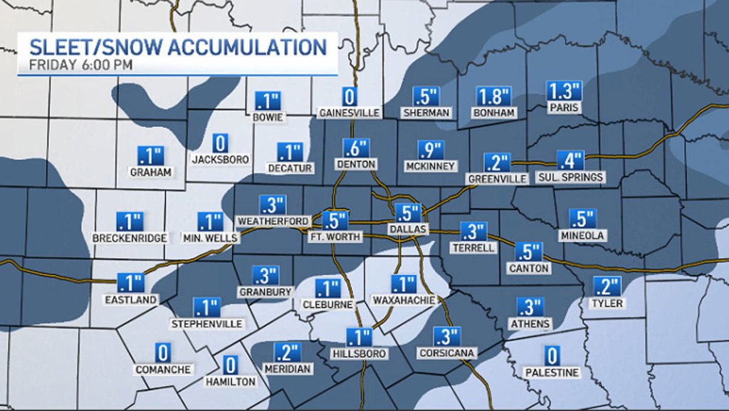
Accumulation is possible across Dallas-Fort Worth, especially farther north.
Another shot of winter arrived early Friday morning in North Texas. A cold front brought cold temperatures and a strong north wind.
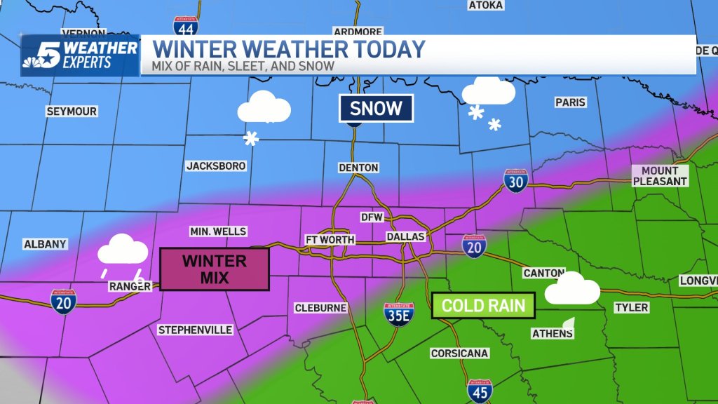
A Winter Weather Advisory across North Texas was expanded overnight to include Fort Worth and Dallas. A wintery mix of rain, sleet, and snow is expected later today.
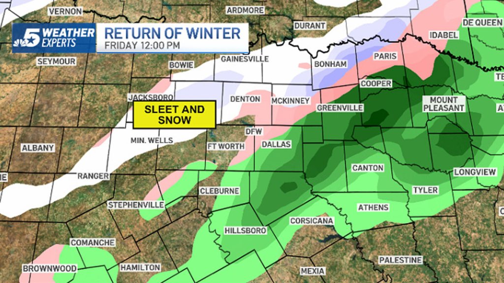
Locations in the advisory have the highest potential for having some slick spots, especially on bridges and overpasses.
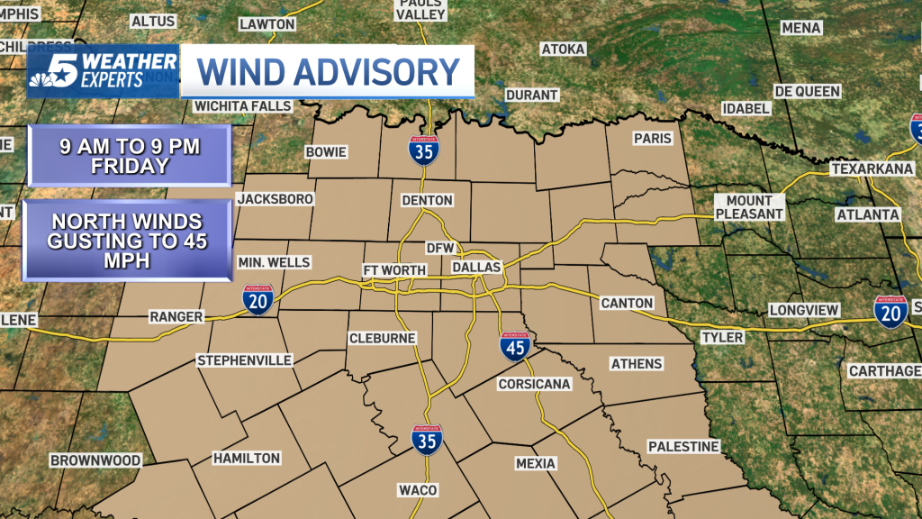
In addition, a Wind Advisory is in effect for Friday for the potential for northerly winds gusting up to 45 mph.
An Arctic cold front pushed sharply colder air into North Texas early Friday. As temperatures fall into the low to mid-30s, rain will change to sleet and snow. In addition, the wind will be very strong from the northwest.
Problems will likely be more significant on the northern sides of the Metroplex. Accumulation of 1/2″ is possible in DFW with higher totals possible farther north. 1-2″ is possible to the north/northeast with the potential for a brief burst of heavy snow. That said, some slushy accumulation even on the main roads is possible.
Some slick travel is possible, especially on exposed, elevated surfaces such as bridges.
The winter mix will taper off by late afternoon. The sky will eventually clear out this evening as the temperature drops into the mid-20s tonight.
Saturday morning temperatures will be in the low to mid-20s. The day will be sunny with afternoon temperatures in the 50s. Expect a bigger warmup Sunday into next week.
It’s a return to winter today across North Texas. A Winter Weather Advisory is in effect until 6 p.m. for DFW.
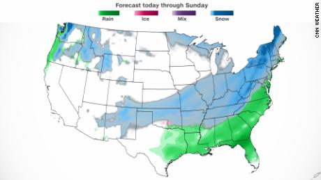
In the Midwest, Kansas and Missouri residents brace for a treacherous wintry mix ahead of the morning commute, with more snow expected for the region.
Temperatures on Friday in areas stretching from Minnesota down through Texas are forecast to plummet 20 to 30 degrees below normal. And by nightfall, snow could begin in the interior parts of the eastern US — making travel miserable for millions.
The storm is expected to strengthen into a bomb cyclone by Saturday and could bring heavy snow and damaging winds to Syracuse, New York, and Pittsburgh among other areas headed toward the interior parts of the Northeast. A bomb cyclone forms when a storm decreases in pressure by 24 millibars (a measurement of pressure) in under 24 hours.
“Snow rates of greater than 1″/hr combined with gusty winds will produce blowing and drifting of snow and severely reduced visibility. This will create difficult to hazardous travel conditions,” the Weather Prediction Center said Thursday.
Winds in parts of the Northeast are forecast to reach between 35 and 45 mph, Marvin Boyd, a meteorologist with the National Weather Service in Burlington, Vermont, told CNN. Widespread snow between 6 and 12 inches, with totals possibly at 15 inches, can be expected, he said.
“Our concern is with the loading on trees. With winds expected to blow 35-45mph, and this heavy wet snow, we could be looking at not only travel problems but numerous power outages,” Boyd said.
Much of Colorado and Kansas on Thursday were inundated with heavy snow, with the greatest totals of 8 to 13 inches falling over western Kansas along interstate 70. To the east, Topeka, Kansas, and Kansas City, Missouri, picked up at least 3 to 5 inches.
The NWS in Kansas City had warned the commute on Thursday and Friday would be messy due to snowy weather. The forecasters said 1 to 3 inches of snow had fallen in the city, which had reduced visibility on roads. Some schools in Kansas City announced they would close on both days due to the hazardous conditions.
Northeast and Mid-Atlantic
The worst of the storm is expected to hit the interior areas of the Northeast beginning late Friday through Saturday, according to forecasts. Those areas are likely to see snow totals exceed 12 inches which could lead to power outages.
The storm is expected to pass between the I-95 corridor and Cape Cod, then along or just off the Maine coast as a sub-970 millibars low, according to the National Weather Service in Boston. The low pressure of the storm is akin to the strength of a category 2 hurricane.
In Syracuse, up to 12 inches of snow could be seen Saturday, with the heaviest amounts falling between midnight Saturday through the afternoon, according to CNN meteorologist Robert Shackelford. And winds are expected to gust up to 45 mph, with temperatures in the 20s.
Portions of Vermont could also see up to 12 inches of snow on Saturday, and winds will also be strong at 40 mph, Shackelford said.
Snow in Pittsburgh could reach up to 8 inches, with the worst conditions happening between early Saturday through noon.
South and Midwest
The storm will also bring snow and low temperatures in areas that typically don’t see those conditions often.
Up to 3 inches of snow on Friday may fall in Albuquerque, New Mexico, and Nashville, Tennessee, where cold temperatures may help black ice form on roads, Shackelford explained. And in Winslow, Arizona, the snow estimates are similar, but winds may gust up to 40 mph.
“Expect winter driving conditions on many area roads, including Hwy 87 from Winslow south to the rim, and SR 260 from Kohls Ranch east through the White Mtns,” the NWS in Flagstaff tweeted early Friday.
Meanwhile, up to 5 inches of snow could fall in Lexington, Kentucky, while Louisville is expected to see up to 3 inches, Shackelford said. And West Virginia could see up to 7 inches of snow. Rain and snow are expected in Huntsville, Alabama, where flash freezing is possible, and winds may gust up to 40 mph.
In the central US, Little Rock, Arkansas, and Oklahoma City could see between 1 and 3 inches of snow — although some local areas in Little Rock may see higher totals. Ice is a threat in Oklahoma City yet Little Rock will likely see rain.
CNN’s Chad Myers and Tom Sater contributed to this report.
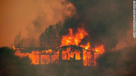
A series of severe storms and substantial rainfall on Wednesday helped firefighters in the Florida Panhandle in their efforts to contain wildfires that are threatening nearby communities, officials said.
Several inches of rain fell across the region, according to the National Weather Service. Some areas west of Tallahassee, near the wildfires, saw more than four inches of rain. Lower amounts were recorded in other surrounding areas.
The blazes, which are collectively called the Chipola Complex had burned more than 34,000 acres by Wednesday evening. They are being fed by dead trees and other vegetation left by Hurricane Michael in 2018, fire officials said.
“This is a living, breathing beast,” Brad Monroe, the chief of emergency services in Bay County, said Tuesday during a news conference. “When it produces its own weather, you see lightning strikes within a fire on a bright sunny day, it’s incredible. Words cannot describe it.”
The largest blaze in the Chipola Complex, the Bertha Swamp Road fire, was more than 33,000 acres in size and was 20 percent contained, according to a Wednesday evening news release from the Florida Forest Service. The fire is centered about 60 miles west of Tallahassee.
“It is a life taker,” Jimmy Patronis, the state fire marshal, said during the news conference Tuesday, adding that residents should not take chances. No deaths or injuries have been reported.
The two other Chipola Complex fires — the Adkins Avenue and Star Avenue fires — have combined to burn a little over a thousand acres and are nearly contained, officials said Wednesday.
Gov. Ron DeSantis said during the news conference on Tuesday that the state was working to provide $6.1 million to help families affected by the fires.
“This whole area has been through a lot in the past three years, starting with Hurricane Michael,” he said. “We need to make sure that they are able to take care of themselves as they take care of others.”
Heavy rainfall was forecast for parts of northwest Florida over the next few days, and more severe weather was expected on Friday, the Weather Service said.
The Florida Forest Service said the wildfire threat remained, with increased winds and low humidity expected this weekend, and that residents should be cautious.
While wildfires have routinely ravaged parts of the American West, that threat could be making its way east.
Recent research has suggested that heat and dryness associated with global warming has been causing fires to grow bigger and stronger, with wildfires becoming a year-round possibility.
Researchers at Intermountain Healthcare in Utah published a study on Wednesday showing an improved method for treating pneumonia in emergency rooms that the system says has reduced mortality by 38%. (Jeffrey D. Allred, Deseret News)
Estimated read time: 2-3 minutes
SALT LAKE CITY — A new method for treating pneumonia in emergency rooms has reduced mortality rates by 38%, according to a study published Wednesday by researchers at Intermountain Healthcare.
In the study, clinicians treated patients using a real-time electronic decision support system called an ePNa. This system makes recommendations to bedside clinicians about how to treat patients.
The support system was used at 16 Intermountain hospitals from December 2017 to June 2019 to treat 67% of the almost 7,000 pneumonia cases hospitalized over time span.
The study found that after using the ePNa, there was a 38% relative reduction in mortality 30 days after a pneumonia diagnosis, including a large reduction in mortality for patients admitted to intensive care.
Researchers also found a 17% increase in “outpatient disposition,” a decrease in admissions to intensive care units and a decrease in the time between emergency department admission and when a patient is first given an antibiotic.
An Intermountain statement says these results are consistent with what health officials saw when they first used ePNa at the company’s larger hospitals.
“Treating pneumonia in emergency departments is challenging, especially in community hospitals that don’t see severe pneumonia as often as urban academic medical centers,” said Dr. Nathan Dean, chief of pulmonary and critical care medicine at Intermountain Medical Center and principal investigator for the study.
Dean explained that ePNa, in addition to making helpful recommendations, allows for treatment from clinicians to be more structured and could decrease unnecessary variations.
“Even if they don’t follow the recommendation, decision-making is more consistent with best practices,” Dean said.
Intermountain says pneumonia is the leading cause of death from infectious diseases in the United States, even before the pandemic.
U.S. News and World Report ranked Intermountain as “high performing in pneumonia care with excellent outcomes” while the study was underway, Intermountain officials said.
The study, “A Pragmatic Stepped-wedge, Cluster-controlled Trial of Real-time Pneumonia Clinical Decision Support,” was published Monday in the American Journal of Respiratory and Critical Care Medicine.
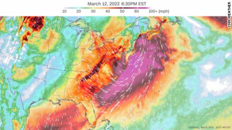
A combination of extremely strong winds and snow promises to wreak havoc over the Northeast as the cyclone reaches hurricane-level strength off the Atlantic coast.
Blizzard-like conditions and widespread wind damage are prominent concerns across the interior of the Northeast.
“All model guidance has surface wave (the storm) rapidly intensifying as it tracks somewhere between the I-95 corridor to Cape Cod, then along or just off the Maine coast as a sub 970 mb low,” said the National Weather Service in Boston.
A 970 millibar low would be equivalent to a Category 2 hurricane.
The low will continue to strengthen overnight Saturday, which, in conjunction with very cold air moving into the area, “will support strong to perhaps damaging winds as the low exits southern New England late Sat into Sat night,” the weather service said.
The models are showing the potential for the low-pressure system to intensify rapidly as it moves northward up the Atlantic coast, creating the potential for a bomb cyclone.
The strongest winds are forecast to be off the coast of the Northeast in the Atlantic Ocean, with winds up to 70 mph possible. However, cities including New York City, Boston and Washington, DC, can expect extremely powerful wind gusts ranging from 30 to 50 mph, which raises concerns for falling trees and power outages across the region.
Along with powerful winds, parts of New England will see heavy snow with accumulations of 4 to 8 inches possible in upstate New York and northern Pennsylvania.
“There is increasing confidence that precipitation will generally be in the form of all snow across far northern Maine, especially the north Maine woods, where significant snow accumulations will be possible Saturday into Saturday night,” the weather service in Caribou said.
Get weekly updates from our team of meteorologists
The combination of significant snowfall in these areas with the strong winds from the bomb cyclone will create the potential for hazardous blowing and drifting snow in the area. This could lead to whiteout conditions and make travel extremely dangerous.
Snow totals along the Atlantic coast are forecast to remain low, with only 1 to 3 inches expected.
The current forecast is calling for 1/2” to 1″ of snow across New York City, metro New Jersey, and central and western Long Island,” the weather service in Upton, New York, said.
Higher elevations of Massachusetts are expected to see 2 to 3 inches, with only a dusting to 1 inch expected near Boston, according to the weather service.
The South will also feel the return of winter
The storm will take aim at the Deep South and Southeast first. Cities including Atlanta, Birmingham, Alabama, and Charleston are expected to see heavy rainfall and possible thunderstorms as the system moves in from Friday night to Saturday morning.
This precipitation will change into a wintry mix in some locations and eventually snow as the cold front causes temperatures to plummet well below average.
Snow is forecast to be seen across parts of many Southern states including Alabama and Mississippi. Even Louisiana could see a few flakes mixed in with the rain.
“Currently in the forecast we have a large area of the region mainly eastern Arkansas and west Tennessee with 1 to 2 inches of accumulation for the Friday night into Saturday morning time frame,” the weather service in Memphis, Tennessee, said.
The fast nature of the storm and the well-above-freezing temperatures will keep snow accumulations to a minimum and limit hazards to travel across the mid-South, according to the weather service in Little Rock, Arkansas.
As the system moves out Saturday into Sunday, extreme winter temperatures will grip the eastern US.
Keep that winter coat out for a little while longer
The start of this week brought widespread warm temperatures across much of the East, with some even setting record high temperatures.
Newark and Central Park both set their highest temperatures on record Monday, reaching 76 degrees and 74 degrees respectively.
But another wave of arctic air following the cold front will bring temperatures to the other end of the spectrum.
Check how cold your temperatures will plunge
“Behind the front, much below normal temperatures are expected from the lower Mississippi Valley through the Ohio Valley on Saturday, and into much of the East by Sunday, with daytime highs 20-30 degrees below normal in some places,” the Weather Prediction Center said.
Low temperatures across the South are forecast to get down into the teens this weekend, with wind chills around zero degrees in some areas.
There is hope for those ready for more of that spring weather in the near future, as warmer temperatures should return early next week.
The Bertha Swamp Road Fire swelled to more than 33,000 acres and is only 10% contained as of Wednesday morning, according to the Florida Forest Service. The fire, the largest currently burning in the panhandle, has moved through land that’s covered by “thick, dry, and dead trees and vegetation left behind from Hurricane Michael,” the agency said.
“It’s the storm that keeps on giving and giving,” Florida’s Chief Financial Officer Jimmy Patronis said Tuesday. “It’s like a ghost, we can’t get rid of the damn thing. If you look at the path of the storm that it has taken when it hit here in October of 2018, it’s the exact same path the fire is taking.”
The Bertha Swamp Road Fire was sparked in Gulf County and spread to Bay and Calhoun counties just east of Panama City, a popular tourist destination, fire officials have said.
Gov. Ron DeSantis activated a state of emergency in all three counties.
The Bertha Swamp Road Fire is one of three that comprise the Chipola Complex Fire, along with the Adkins Avenue Fire and the Star Avenue Fire, officials said. The complex fire has scorched more than 34,000 acres in all. The Adkins Avenue Fire has burned 875 acres and is 80% contained, and the Star Avenue Fire is about 200 acres and 80% contained, the forest service said.
Light, steady rain is expected on Wednesday and will reduce the heat and intensity of the Bertha Swamp Fire and allow better access to firefighters.
Over the weekend, the fires forced nearly 1,100 homes to be evacuated, though all evacuation orders for the Adkins Avenue and Star Avenue fires have been lifted.
The Broad Branch community near Kinard in Calhoun County was evacuated Tuesday due to the Bertha Swamp Road Fire, officials said.
“Over the last few days, gusty winds have picked up in the early afternoon and lasted through the evening, causing erratic fire behavior. Weather conditions today are no different and forced additional evacuations in Calhoun County,” the forest service said. “While the weather forecast in the coming days calls for a possibility for rain, it will not be enough to decrease the wildfire threat any time soon.”
CNN’s Jamiel Lynch and Tina Burnside contributed to this report.
It’s the first taste of what looks to be an increasingly active weather pattern heading into mid-March, with several additional storm systems that bear watching in the coming weeks.
A weekend of violent storms
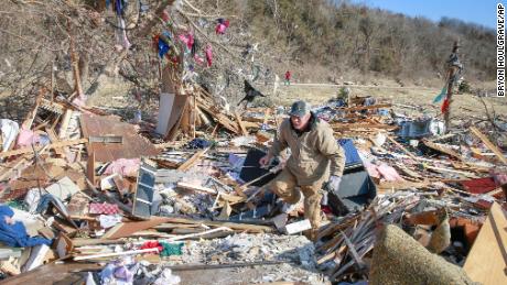
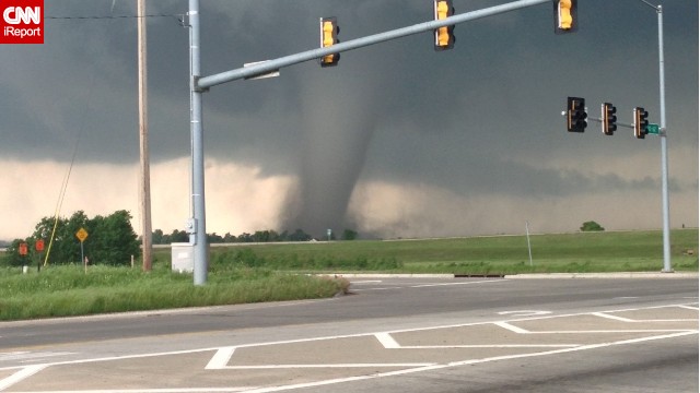
The weekend began with a major tornado outbreak in Iowa that left seven people dead, including six from a wedge tornado that carved a lengthy path south of Des Moines. Parts of Winterset, a small city about 25 miles southwest of Des Moines, was leveled, with damage observed to be at least EF3 strength on the 0 to 5 scale for twister intensity. That would correspond to winds exceeding 136 mph, though the National Weather Service has yet to release their final rating.
Remarkable video captured by Adam O’Neill of Winterset, Iowa. He & wife Jenn were hosting their son’s b-day party when this tornado went over their house, destroying every building on their farm. All OK, sheltered in the basement. @weatherchannel is coveraging the #Iowa tornado🌪 pic.twitter.com/ppF1mV5hHv
— Justin Michaels (@JMichaelsNews) March 6, 2022
That tornado may have been on the ground semi-continuously for an hour or more, the parent thunderstorm tracking 150 miles through southern and central Iowa. Another deadly tornado, rated an EF3, impacted Chariton, Iowa, about 50 miles south-southeast of Des Moines, with a path length confirmed at 16.5 miles. Now, a plastering of snow blankets tornado damage.
On Sunday, the instigating cold front sagged south, where it encountered warm, moisture-rich air over Arkansas and southern Missouri. Four additional tornadoes were reported, though a number of tornado-warned storms continued their malicious prowl overnight, and more twisters will probably be confirmed as damage reports stream in.
Story continues below advertisement
Five people were injured near Zion, Ark., about 125 miles north of Little Rock, as a severe thunderstorm with a possible tornado damaged two homes.
The setup for Monday’s storms
The thunderstorms are tied to an advancing cold front and “shortwaves,” or lobes of high-altitude cold air, low pressure and spin, swinging around a larger blob of cool weather to the west. As each one propagates northeastward, it enhances upward motion ahead of it, helping storms to blossom.
Ahead of the cold front, southerly winds are pumping in anomalous and, in some locales, record-breaking warmth. Washington should hit 80 degrees today, eclipsing the record of 77 set back in 1961. Philadelphia should break their record of 74 degrees too, and Baltimore is in line for a record as well.
Humidity and instability, or “juice” for thunderstorms, will be limited — but plentiful jet stream energy aloft will provide momentum so that downpours will mix to the surface in the form of strong gusts. A squall line will continue to take shape through the afternoon, pushing east.
The National Weather Service Storm Prediction Center has issued a level 2 out of 5 slight risk for severe weather, which includes Philadelphia, Washington, Baltimore, and Atlanta. That’s where gusty to locally damaging winds will be scattered about.
Story continues below advertisement
Areas to the west will see storms earlier, with boomers arriving along the Interstate 81 corridor by 4 p.m. and approaching Interstate 95 around 6 or 7 p.m. Damaging winds are the main concern, with a few embedded pockets of 50 to 60 mph gusts probable.
Flooding concerns are negligible, since the storms are progressive, meaning they’ll be moving swiftly through the area and won’t linger.
Behind the cold front and attendant storms, temperatures will tumble Monday night, falling back through 40s across the Mid-Atlantic, with 30s in interior zones.
Beyond Monday night, two opportunities for active weather appear probable. First, there may be some vigorous storms from the Deep South to the Mid-Atlantic late this week into the weekend.
Thereafter, we’ll see cold air linger across the central and eastern U.S. for several days until the middle of next week, when an insurgence of warm, moist air will waft over the southern Plains and perhaps Mid-South. With signs that a more significant storm system will roll in from the west, there will probably be more severe weather in the March 15-19 time frame.
A tornado watch is in effect until 2 a.m. CT Monday for portions of western and northern Arkansas into southern Missouri, according to the National Weather Service. Damaging winds, isolated large hail and the potential for tornadoes remain a threat for the region into Monday morning.
Multiple tornadoes were reported in the watch area Sunday evening, said CNN meteorologist Michael Guy.
“Primary threats into the early morning hours include the potential for a few tornadoes, in which a couple could be intense. Scattered damaging winds are also likely with isolated significant gusts to 75 mph,” Guy said.
A spokesperson for the Arkansas Division of Emergency Management said there was tornado damage and multiple downed power lines near the Martin Township area, about 70 miles northwest of downtown Little Rock, with one injury reported.
A family was reported to be trapped in their storm shelter but were later able to be helped and are safe, according to the agency.
The Pope County Office of Emergency Management in northwest Arkansas asked people to avoid the area “as emergency responders and other officials work in the area to clean up and check on residents.”
As residents brace for more potentially severe weather in Arkansas and Missouri, recovery efforts are ongoing in Iowa, where several tornadoes touched down near Des Moines Saturday. Seven people, including two children, died in the storms, officials said.
Six Madison County residents were killed, according to county Emergency Management Director Diogenes Ayala. The oldest victim was 72 years old and the youngest was aged 2, Ayala said at a news conference in Winterset Sunday afternoon. He had earlier said there were two victims under 5.
A person in a rural area near the Lucas County city of Chariton was also killed, an official said.
Six people in Madison County were being treated for injuries sustained in the tornado, according to officials. Ayala previously said one adult had life-threatening injuries and three others had been hospitalized in serious condition.
“This is, I think, the worst anyone has seen in quite a long time,” Ayala said Sunday.
At least 2 EF3 tornadoes hit Iowa, NWS says
After the severe weather passed through, many residents began the arduous process of recovering from the damage inflicted.
In Des Moines, Shannon Brown told CNN affiliate KCCI she had just parked her Jeep at her home when the storm struck, with a tree crashing down on top of the vehicle. She was not harmed and said she was grateful for others in the community helping with cleanup efforts.
“You really realize who cares about you and just makes you feel special, you know you have all these people who are willing to help you,” she told KCCI.
Complicating the situation Monday is a cold front moving through the state, with areas hit by tornadoes now set to experience snowfall. The southern portion of the state began receiving snow late Sunday.
At least two of the tornadoes that hit on Saturday were preliminarily categorized by the NWS’ Des Moines office as EF3 intensity, meaning winds of 136-165 mph.
An initial estimate of the Madison County tornado that impacted Winterset showed it was an EF3, the NWS said.
Iowa Gov. Kim Reynolds issued a disaster proclamation for Madison County, allowing state resources to be used for response and recovery efforts, according to a news release. Additional counties may be added to the proclamation.
The Chariton tornado is also estimated to have been an EF3 with winds of 138 mph and was on the ground for more than 16 miles, according to preliminary NWS surveys.
Other tornadoes that touched down include an EF2 with estimated winds of 122 mph near Leon, which was on the ground for 19 miles, the NWS said.
An EF1 tornado with 110 mph winds occurred in Vinton, an EF1 with 100 mph winds struck in West Lake Park and an EF-0 tornado also impacted West Lake Park with 65 mph winds, according to the NWS.
The agency said Sunday it is still conducting damage surveys across the state and is working to determine how many tornadoes occurred.
CNN’s Andy Rose, Melissa Alonso, Jennifer Feldman, Allison Chinchar, Gene Norman, Hannah Sarisohn, Susannah Cullinane and Aya Elamroussi contributed to this report.
Eating disorder recovery advocate Christine Parks hikes Denali National Park. Since the pandemic began, there have been documented increases in eating disorders in the U.S., Canada, Australia, Europe and the Middle East. (Christine Parks)
Estimated read time: 11-12 minutes
SALT LAKE CITY — When employees at a local eating disorder clinic asked a teenage resident why she was refusing to eat, the teen lifted up her shirt and pointed at her stomach.
“I would rather die than have tummy rolls,” she said.
Christine Parks, a care technician who witnessed the interaction at Utah’s Center for Change, has gone through recovery for eating disorders and felt flooded with emotion — and protectiveness.
She knew that the girl’s statement was not an exaggeration. Eating disorders have the highest mortality rate of any mental illness, and they are impacting teenage girls now more than ever.
Experts say that since the COVID-19 pandemic began, there have been documented increases in eating disorders in the United States, Canada, Australia, Europe and the Middle East.
According to a study from the Centers for Disease Control and Prevention released last week, emergency room visits for eating disorders doubled among 12- to 17-year-old girls nationwide since the pandemic began. And those are just the cases that are life-threatening enough to warrant emergency admission during a pandemic.
The National Eating Disorders Association has reported a 107% increase in calls to their help line since March 2020.
Researchers have found a number of potential reasons for the growing number of eating disorder cases, including having to eat meals in front of others, having less-structured meal times, exercising at home using videos on social media and apps, video conferencing and increases in stress levels.
Multiple studies have shown that the heightened attention to weight gain on social media during lockdown led people to increase their physical activity to an excessive level out of fear. One 2021 study from the University of Connecticut Rudd Center for Food Policy and Obesity found that over 50% of teenagers saw social media content that stigmatized weight gain during that time period.
Although no organizations are quantifying exactly how many eating disorder cases there are in Utah, the demand for treatment has skyrocketed since 2020.
“Every person I know is full or has a waitlist and has closed their waitlists, including dietitians and people working at hospitals. I have colleagues who prefer not to treat eating disorders, and it’s not an option anymore,” said Dr. Corinne Hannan, a psychologist specializing in eating disorders and assistant clinical professor at Brigham Young University.
“From my chair, it’s not showing any decline. Quite the opposite,” she added.
A culture of perfection
When a former college track athlete, who asked to remain anonymous for privacy reasons, arrived at the Utah university a couple of years ago, she noticed a pattern in the people around her that she said she didn’t see nearly as often in her home state.
She said it was completely normal for her friends and teammates to eat foods they deemed unhealthy or fattening and then compensate by “running it off” for miles and miles or exercising excessively. In fact, she said this behavior was rewarded and encouraged. She said her coach at the time even told her to lose 3 to 5 pounds, even though she was regularly exercising and lifting weights.
Excessive or compulsive exercise as a form of purging is also known as anorexia athletica or exercise bulimia, but it is not a recognized clinical eating disorder in the Diagnostic and Statistical Manual of Mental Disorders. However, the National Eating Disorder Association website states that compulsive exercise can be a symptom of disordered eating or a recognized eating disorder, and the symptom itself can lead to bone density loss, loss of menstrual cycle in women, and other severe medical conditions, some of which can be life-threatening.
Hannan explained that it was impossible to find data on how many Utahns are dealing with eating disorders because the data does not exist. There’s not enough research being done and not enough funding for researchers to pursue it.
The former athlete’s mother, Michelle, who runs an international Facebook group for family members of people with eating disorders, expressed that another problem gathering this data is that everyone has different definitions of what recovery means. So local treatment centers, which go largely unregulated, might not report accurate recovery rates.
Every person interviewed for this story mentioned a culture of toxic perfectionism that applies to appearance.
Hannan speculated that the high rates of perfectionism she sees in clients and students in Utah occur because of an association with physical perfection and religious worthiness or an unconscious need to stand out as the most perfect in a homogenous crowd of other white, slim people who make up the majority demographic of the state.
No matter the reason, it is impossible to drive down a freeway without coming across billboards telling you to change your appearance through plastic surgery, cool sculpting or dieting, Park said.
“It’s definitely a beauty-saturated place,” she continued. “Hair extensions, fake eyelashes, spray tans: It’s almost like the expectation is that everyone should have that. … How did we get here? How did Utah’s beauty ideals become like this? It’s so preventable.”
No specific look or size
Although the reported number of hospitalizations is growing specifically among adolescent girls, eating disorders do not pertain only to people of a certain look or size.
Eating disorder recovery advocate Christine Parks eats a pumpkin cupcake in Washington, D.C. (Photo: Christine Parks)
During Parks’ work at Center for Change, she has come across grandmothers who have had an eating disorder for 40 years, military personnel, athletes, mothers, and people of all ages and backgrounds.
“You can never tell based off looking at someone,” she said. “It gives me so much more compassion for anyone who struggles with food and body issues because it’s truly an invisible disease. Everybody is worthy of getting help.”
Multiple studies show that marginalized populations like people of color and members of the LGBT community have higher rates of developing eating disorders. And children are far from immune, as some Americans are putting children on diets at younger and younger ages.
“I wish the average person understood that eating disorders are not something you can diagnose with your eyes. They are underdiagnosed and underrepresented due to misinformation and normalization and promotion of disordered eating of society,” Hannan said.
Anyone of any ethnicity, gender, size, age or ability could possibly have an eating disorder, she added, but the biggest predictor of youth developing an eating disorder is dieting.
Effects of social media
Parks was 15 years old when she first started developing orthorexia, an eating disorder characterized by an obsession with healthy eating. She didn’t see it as a problem. After all, she told herself, she was just trying to be healthy.
This was also when Instagram was fairly new, and it became the breeding ground for her issues with food.
“I 100% used it as a resource to figure out how to lose weight. I remember looking up strategies of what to do when I’m hungry instead of eating,” she said.
Now, after recovering from her years of being trapped in a cycle of heavily restrictive eating — becoming nutritionally and calorically deprived, binging secretly and resetting weight loss goals in shame — she runs an account specifically dedicated to eating disorder recovery on the same platform that encouraged her illness: Instagram.
When she was an undergraduate at Brigham Young University, all-consuming thoughts of food terrorized her during 90% of her waking hours. She began to isolate herself from everyone, even planning her walks across campus to avoid crowds so she wouldn’t be seen because she “didn’t feel worthy or valuable as a person until (she) was thin enough.”
Eating disorder recovery advocate Christine Parks hikes in Rock Canyon Park in Provo. (Photo: Christine Parks)
In 2019, she attended a meeting on campus that addressed disordered eating and eating disorders and promoted intuitive eating, or making peace with food and relying on your body’s cues to decide what and when to eat.
As Parks began to work with a dietitian and a therapist to get her life back, she came across a quote from Dr. Thema Bryant, a psychologist and minister, that inspired her to write about the eating disorder she had kept hidden for so many years.
“When you shatter the shame and begin sharing your story, a thousand chains will fall off people you never met,” Bryant wrote.
Parks wrote out her story in a blog post titled, “The eating disorder that no one talks about.” She took a deep breath and clicked “publish.” The response from her community was immediate.
“Messages upon messages came pouring in from people I know and people I didn’t know,” she said.
Later that year, she decided to start an Instagram account called @ed_stories. She shared 120 recovery stories within the first year from people across the country and abroad.
“Advocating lights my soul on fire,” Parks said, and her experience running the account has shown her social media’s “incredible capacity for good.”
“Now I follow a million therapists and dietitians in the eating disorder space. You can curate your feed for recovery,” she said. “But it does need to be heavily regulated and monitored.”
The National Eating Disorder Association website states that 7 out of 10 women and girls report a decline in body confidence attributed to pressure to attain society’s unrealistic beauty standards.
In October, Frances Haugen, a Facebook data scientist turned whistleblower, leaked internal Facebook studies that showed that Instagram harmed teenagers. One study, in particular, showed that 17% of teenage girls reported that the app made eating disorders worse. Haugen testified before Congress on Oct. 5, 2021, stating, “Facebook knows that they are leading young users to anorexia content.”
When Hannan heard this news, she was disappointed and angry but unsurprised.
“There is a substantial body of research showing how social media can contribute to disordered eating and body negativity. The issue with Facebook is a continuation and magnification of an already existing problem,” she said.
It is almost impossible to use social media without coming across millions of money-making accounts that invent a flaw, make you feel insecure, and then sell you a solution, Hannan explained. And youth are using social media for hours as a part of their daily routine.
“Companies with all this power and influence are preying on the most vulnerable of us: teens and children. There’s no accountability and no ethics. It continually breaks my heart,” she said.
However, she also believes social media can reach and connect people worldwide in an unprecedented way and share accurate information. But doing so in a way that competes with the multibillion-dollar diet industry takes a lot.
Although she hasn’t done publishable research on curating a social media feed, Hannan has found that if she only followed and interacted with very specific accounts, she could limit the amount of damaging material she was exposed to.
“I wouldn’t be surprised if curating a media feed that supports your recovery is as powerful as being exposed relentlessly to hours and hours of images,” Hannan said, and she’s optimistic that people with the time and team will create content to make a better world.
Parks also said she doesn’t recommend blocking teens from accessing social media. Instead, she suggests taking breaks, paying attention to the research being done on social media consumption, educating teenagers about the risks, unfollowing any accounts that promote unhealthy behaviors or comparison, and following specialists and doctors involved in eating disorder recovery and intuitive eating.
Recovery is possible
The biggest point every interviewee emphasized was that recovery from eating disorders is absolutely possible.
Hannan’s clients sometimes refer to the journey to recovery with pop culture references, like Frodo destroying the ring in “Lord of the Rings” or Ron Weasley having to face all his worst fears before destroying a horcrux in the Harry Potter movies.
Michelle recommends that parents and supporters help their loved ones with eating disorders find evidence-based treatment that will lead to long-term recovery.
Rewiring the brain doesn’t happen overnight, but for Parks, recovery looks like getting her life back: dating, creating and deepening relationships with friends, being present with family, pursuing a career, and living a fulfilling and happy life.
She still struggles occasionally, but she really does feel as though a thousand chains have fallen off her since she began recovery. She is miraculously, gloriously free.
Resources for people dealing with eating disorders
The two children who died were under the age of five, Madison County Emergency Management Director Diogenes Ayala said.
“This is, I think, the worst anyone has seen in quite a long time,” Ayala said.
The tornado in Madison County, which is southwest of Des Moines, also left one adult with life-threatening injuries and three others hospitalized in serious condition, Ayala said.
The National Weather Service office in Des Moines said an initial estimate shows it was an EF3 tornado, with wind speeds of at least 136 miles per hour.
“This is a widespread storm,” Ayala said. He estimated there was serious damage to more than two dozen homes.
Iowa Gov. Kim Reynolds issued a disaster proclamation for Madison County, saying she and her husband are praying for the lives claimed and those injured in the tornado.
“Our hearts go out to all those affected by the deadly storms that tore through our state today,” Reynolds said in a news release Saturday. “Our hearts ache during this time, but I know Iowans will step up and come together to help in this time of need — they already are”
The proclamation allows state resources to be used for response and recovery efforts in Madison County, according to the news release. Other counties may be added to the proclamation.
Severe storms were forecast for Iowa, including in Des Moines, Saturday afternoon and evening.
Typically in March, severe weather is focused over the Gulf Coast states, from Texas to Florida. For example, Texas averages 11 tornadoes in March, while Iowa typically only sees two.
CNN’s Melissa Alonso, Jennifer Feldman and Allison Chinchar contributed to this report.