Tag Archives: tornadoes

Elsa storm update: NC weather radar shows tropical storm bands arriving in North Carolina, could bring tornadoes, power outages

RALEIGH, N.C. (WTVD) — Outer bands of rain from Tropical Storm Elsa started moving into the North Carolina Sandhills around 5 a.m.

According to the 5 a.m. update from the National Hurricane Center, the center of the storm was located about 50 miles south of Columbia, South Carolina. Elsa was traveling northeast at 18 miles per hour.

WATCH LIVE: Radar shows current location of Elsa

The storm is expected to quickly continue its way up through North Carolina, tracking just west of Interstate 95.

Elsa remains a weak tropical storm with sustained winds at 40 miles per hour.

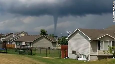
Elsa is expected to dump between 1-3 inches of rain (with isolated areas getting as much as 6 inches of rainfall) in central North Carolina and bring wind gusts as strong as 50 miles per hour in spots. Elsa also brings with it an isolated tornado threat.

Timeline

Showers began around 5 a.m. in the Sandhills on Thursday. As the day progresses, the rain spreads north across the ABC11 viewing area with the entire region seeing rain and storms by the afternoon.

Peak wind gusts Thursday will happened between 9 a.m. – 4 p.m. south of Wake County. Areas north of Wake County can expect the strongest winds between 11 a.m. – 7 p.m.

Elsa will move through North Carolina fairly quickly. The majority of the storm will be into Virginia by 9 p.m.

To get the latest weather alerts sent straight to your phone, download the ABC11 mobile app

Friday will be partly cloudy with highs in the low 90s. The weekend looks mostly sunny with that heat remaining in the lower 90s.

North Carolina Preparations

The State Emergency Operations Center in Raleigh activated on Tuesday to monitor the storm.

“Residents and visitors to North Carolina should keep a close watch on the forecast for this storm,” Gov. Roy Cooper said in a statement on Tuesday. “It’s important that everyone be aware and prepared for rains, and it’s also important to avoid driving through floodwaters.”

SEE ALSO: Tropical Storm Elsa kills 1 in Florida, hurts 10 at Georgia base

The state’s emergency response team has reached out to local governments, making sure they have everything they need before Elsa arrives.

State leaders say individuals should also be sure they have everything they need in their emergency kits, including an evacuation plan and essential goods.

WATCH: What you need in your hurricane preparedness kit

Meanwhile, City of Raleigh is using an online system to automatically lower the water level at Johnson Lake.

The system lessens the amount of water flowing out of the dam down stream, leaving more room for the lake to fill up during a storm.

Before the installation of the automatic online system, City of Raleigh officials would have to go to Lake Johnson in person to open the valve.

Johnston County Public Schools announced that its Summer Learning Program would be canceled for students at all sites on Thursday, July 8. Friday, July 16 will serve as a makeup day.

All Durham Public Schools’ Summer programs were also canceled for Thursday.

The Associated Press contributed to this article.

Copyright © 2021 WTVD-TV. All Rights Reserved.


Read original article here

Millions in the Southeast under threat of severe weather, including possible tornadoes

Heavy rain that could cause flash flooding is forecast to impact the Tennessee Valley through Kentucky. This includes the metro area of Nashville, which was hit hard by flooding over the weekend.

Over 39 million people from Louisiana through the Mid-Atlantic could see severe storms. The largest impacts from these will be damaging straight line winds from the Gulf Coast through the Carolinas; however the potential for isolated tornadoes exists with these storms as well.

After this extreme weather passes, the temperatures will plummet to sub-freezing in the overnight hours with the potential for snow across the Appalachians into New England.

The newest severe weather forecast follows a storm that left at least seven people dead and caused widespread damage around the Nashville area last weekend.

The heavy rain prompted flash floods that swept cars into inescapable currents, and damaged dozens of homes and buildings.

Further south, cities in Alabama and Georgia are still cleaning up from terrifying tornadoes that tore through, killing six people, last week.

The tornadoes damaged dozens of homes and businesses across the two states.

In Alabama, the community of Eagle Point saw roofs ripped off houses, trees plucked from the ground, and power lines downed across roadways.

In Georgia’s Coweta County, the city of Newnan was hit by a powerful EF-4 overnight, with residents being warned by sirens 15 to 20 minutes before the tornado hit, residents told CNN.

The storms killed at least one person in the county, Fire Chief Deron Patrick Wilson said.

“This stuff is unbelievable. I kind of think about this kind of stuff when you look out in the Midwest, Oklahoma. I think you’re going to see that same kind of damage here,” Wilson said.

Warm and cold air masses causing chaos

Meantime, parts of the country are experiencing sharp fluctuations in conditions within a short period of time.

A cold Canadian air mass to the west has bumped against warm air as it moves east, creating winds in excess of hurricane strength in areas.

Wind gusts of 79 mph were reported in Hettinger County, North Dakota, just to the south of Dickinson, on Monday, a part of the same front and winds that caused the fires in South Dakota.

A record high of 81 degree Fahrenheit was recorded in Aberdeen, South Dakota, on Monday — 33 degrees above normal. After winds pushed the cold mass in, temps struggled to reach 39 degrees.

Below average temperatures are surging into the eastern United States on Wednesday behind a cold front, with the exception of one last warm day across eastern New England.

As that cold front passes — temperatures will also drop dramatically, putting more than 21 million under freeze watches or warnings from the Central Mississippi Valley through the Ohio Valley through the mornings of Thursday and Friday, where temperatures will be in the upper 20s.

It will even be cold enough for lake-effect snow for portions of the Great Lakes: “The core of the cold air (in the atmosphere) will spread over Lake Michigan tonight into early Thursday, which brings us into the month of April. Not too often we discuss lake effect snow in April, but this will be one of those/albeit brief periods,” said the National Weather Service office in Chicago.

Winter weather will also be seen again across the Appalachians of West Virginia, the Eastern Great Lakes into portions of New England between Wednesday night and Thursday night. Six to 10 inches of snowfall is expected western and Upstate New York, with lower totals elsewhere.

Meanwhile across the western US, temperatures are above average midweek, but by later this week that milder air will shift east into the central US.

Widespread high temperatures of 5-15 degrees above average are forecast by Friday from the West through the Great Lakes. The northern Plains will be the warmest relative to normal, with temperatures up to 30 degrees above average.

Temperatures will warm up further for the Easter weekend, with potentially record-breaking highs up to 40 degrees above average for the northern Plains. By the end of this weekend, coast-to-coast warmth is forecast except for portions of the Northwest and Florida.

Read original article here

Southern Storms: Tennis ball-size hail forecast as powerful storms and violent tornadoes threaten South

The worst of the severe weather will likely stretch from parts of the Lower Mississippi Valley into Alabama, with several rounds of storms possible for parts of Mississippi and Alabama from Wednesday afternoon and into the night, according to the Storm Prediction Center.
The center is warning of “high risk” for severe weather — a category level that’s not taken lightly and used on average only once or twice per year. There were no “high risk” days in 2020. The last one was in May 2019.

About 11 million Americans in that region are at a higher risk for long-track tornadoes Wednesday, CNN meteorologist Michael Guy said.

The National Weather Service in Birmingham, Alabama, warned that “strong to violent tornadoes are expected.” Some areas are at a high risk of violent long-track tornadoes, damaging winds of over 80 mph as well as tennis ball-sized hail, the service said.

Long-track tornadoes are the ones that consistently remain on the ground for an extended period of time, unlike a typical one that could be on the ground for just minutes.

The Alabama Emergency Management Agency warned the storms could be a “dangerous and life-threatening event.”
In response to the forecast, Alabama Gov. Kay Ivey issued a state of emergency, saying in a statement she did so “out of an abundance of caution.”

“Projections are showing that this will likely be a widespread event, with some of the most severe weather anticipated late Wednesday night into early Thursday morning,” Ivey said in a statement.

“Please make preparations now in the event your area is impacted in some way. I will continue keeping a close eye on the system and encourage every Alabamian to do the same,” the governor added.

Other officials also urged residents of the state to prepare Tuesday.

“Ensure you have multiple ways to receive warnings,” the weather service in Mobile wrote on Twitter. “Also have a plan on a safe place to go should a warning be issued. Please, do NOT focus on the exact risk level. Everybody in the region needs to be prepared for significant severe weather!”

CNN’s Dave Alsup, Jackson Dill and Jennifer Gray contributed to this report.


Read original article here

Texas sees multiple tornadoes touch down as severe weather rips through

Multiple tornados touched down in northwest Texas on Saturday afternoon amid severe thunderstorms.

The National Weather Service issued a tornado warning for the Texas panhandle until 10 p.m. CST. 

Texans were warned to stay inside and seek shelter. 

Storm clouds in Randall County, Texas, on Saturday. (FOX 34 of Lubbock and Randall County Sheriff’s Office)

“Flying debris will be dangerous to those caught without shelter,” the National Weather Service said. “Mobile homes will be damaged or destroyed. Damage to roofs, windows, and vehicles will occur. Tree damage is likely.”

The scene in Randall County, Texas, on Saturday. (FOX 34 of Lubbock and Randall County Sheriff’s Office)

AS MASSIVE STORM SLAMS THE WEST, FLOODING, TORNADOES, HAIL POSSIBLE ACROSS THE SOUTH

An ominous view in Randall County, Texas, on Saturday. (FOX 34 of Lubbock and Randall County Sheriff’s Office)

A tornado near Palo Duro Canyon just south of Amarillo unleashed 80-85 miles per hour winds around 3:11 p.m.

CLICK HERE FOR THE FOX NEWS APP

Large hail and severe winds posed a threat to the Texas panhandle as well. 


Read original article here

Storms, floods and maybe tornadoes on Sunday

CLOSE

Severe storms and a few tornados are possible in Nashville and much of Middle Tennessee on Sunday night, ending a month of scattershot weather that already made the region more vulnerable to flash flooding.

The National Weather Service forecasts that “a line of severe storms” will arrive in Middle Tennessee between 6 p.m. to midnight, and the western half of the state is under a tornado watch until 10 p.m. Even in areas with no tornadoes, storms are expected to bring damaging winds up to 60 mph and another 1 to 3 inches of rain.

National Weather Service meteorologist Sam Herron said any damage reported has been isolated. Parts of Middle Tennessee saw gusts of high-speed wind, flash flooding and hail. 

Current warnings and watches

Flood advisory: A flood advisory was issued by the NWS for cities in Cheatham and Montgomery counties along the Cumberland River through Thursday morning. The river is expected to swell to a crest of 43 feet. Low areas near the river could flood. 

Davidson County is under a flood advisory for the Stones River near Donelson and for the Cumberland River near downtown. 

Flash flood warning until 11 p.m.: Davidson; Maury; Rutherford; Smith; Williamson; Wilson. 

Between 1 and 2.5 inches of rain have fallen. Flash flooding is ongoing or expected to begin shortly. Turn around, don’t drown when encountering flooded roads. Most flood deaths occur in vehicles. A Flash Flood Warning means that flooding is imminent or occurring. If you are in the warned area move to higher ground immediately. Residents living along streams and creeks should take immediate precautions to protect life and property.

There is a considerable threat, NWS reported. 

Tornado watch until 10 p.m.: Giles; Lawrence; Lewis; Marshall; Maury; Wayne; Williamson; 

Severe thunderstorm watch until 10 p.m. Bedford; Cannon; Coffee; Cumberland; De Kalb; Fentress; Grundy; Jackson; Overton; Pickett; Putnam; Rutherford; Smith; Van Buren; Warren; White; Wilson. 

Flash flood watch through Monday afternoon: Franklin, Lincoln and Moore counties. 

Storm effects 

Flash flooding was reported throughout Stewart County around 7:15 p.m. 

Multiple roads were flooded across Robertson County around 7:30 p.m. 

Dickson County Schools will be reporting to class two hours late due storm damage. 

Wind speeds of up to 54 mph were measured at the John C. Tune Airport in Nashville around 7:45 p.m. 

Quarter-sized hail was spotted in southeastern Davidson into Wilson County. 

1,300 outages were reported by the Nashville Electric Service. 

Nashville weather radar

Middle Tennessee forecast

The rain may lead to sudden flooding in areas with poor drainage and is likely to swell creeks and streams immediately and cause large rivers to rise over the next few days, said meteorologist James LaRosa.

“Everything is already so wet, not just from the rain we’ve had, but also the snow,” LaRosa said. “The snow and ice that melted really saturated our soil, so whatever rain we get runs off very quickly.”

As of Sunday morning, the weather service predicted there was a 5% chance of a tornado within 25 miles of any given spot in much of Middle Tennessee and all of West Tennessee. Both Nashville and Memphis fell within this forecast area.

The weather service predicted a lower risk of about 2% reaching east to about Claiborne County.

La Rosa said Sunday storms would likely begin in the Clarksville area, which can expect heavy rainfall and possible flash flooding during the day. Nashville and surrounding counties are unlikely to see heavy rain until the afternoon and evening.

He urged Tennesseans to ensure they had a way to monitor the weather conditions throughout the night, when the storms will be at their worst.

“Have a plan to receive weather information overnight, whether it’s with your phone or weather radio,” LaRosa said. “The time is not great — overnight hours are when people are sleeping, so they aren’t weather aware — so just make sure you have an option to get weather information.”

Most of the storms should be over by daybreak on Monday, although some areas are likely to have lingering showers in the morning, LaRosa said. The weather is forecast to dry out on Monday night, followed by a 30% to 50% chance of more showers on Tuesday, then partly sunny and mostly clear skies on Wednesday.

Read or Share this story: https://www.tennessean.com/story/news/2021/02/28/middle-tennessee-weather-storms-floods-possible-tornadoes-sunday/6859784002/

Read original article here

The Ultimate News Site