Southeast Michigan was under a wind advisory until 9 p.m. on Saturday with gusts topping 60 mph.
As of 7 a.m. on Sunday, more than 20,000 DTE Energy customers were without power in Southeast Michigan.
Stay at least 20 feet away from downed power lines and anything they are in contact with, including puddles of water and fences. Keep children and pets away too.
Be extremely cautious near metal fences, which conduct electricity, following a severe storm. Electric current will be the strongest where a downed power line is touching a metal fence. Even a connecting fence several backyards away can be energized and dangerous.
Never cross yellow barrier tape. It may be around downed power lines.
Never drive across downed power lines. If a power line falls on your vehicle, remain inside your car until emergency help arrives.
A live power line may spark and whip around as it looks for a ground. A ground is the earth or something touching the earth, like a fence or a tree. A live wire that has found its ground may lie silently, but it is still dangerous. Report a downed power line online, on the DTE Energy Mobile App or call us immediately at 800.477.4747.
Cable or telephone lines can be energized if they come in contact with electrical lines. Contact with any energized power line can be fatal.
Never use a portable generator inside a home or business. It emits carbon monoxide, which can be deadly. Keep it outside, away from windows and doors, so the fumes won’t come in.
UPDATE (8 p.m.): Severe thunderstorm warnings are in effect for Lac qui Parle, Stevens and Swift counties until 8:45 p.m.
Forecasters say the storm system is moving northeast at 50 mph, threatening 60 mph wind gusts and quarter-sized hail.
⚠️ SEVERE T-STORM WARNING for areas shaded in orange until 10/09 8:45PM. Severe storms can produce hail 1″ or larger, 60+ mph winds & tornadoes. Move to an interior room on the lowest floor of a sturdy building. https://t.co/hcQdTh3wDG #mnwx #wiwx pic.twitter.com/48iXsnBQUI
— WCCO – CBS Minnesota (@WCCO) October 10, 2021
UPDATE (7:29 p.m.): Severe thunderstorm warnings are now in effect for Grant, Otter Tail and Wilkin counties until 8:30 p.m.
The National Weather Service says the storm line is moving about 50 mph across west-central Minnesota, threatening 60 mph wind gusts and quarter-sized hail.
⚠️ SEVERE T-STORM WARNING for areas shaded in orange until 10/09 8:30PM. Severe storms can produce hail 1″ or larger, 60+ mph winds & tornadoes. Move to an interior room on the lowest floor of a sturdy building. https://t.co/hcQdTh3wDG #mnwx #wiwx pic.twitter.com/dyNhivpAi4
— WCCO – CBS Minnesota (@WCCO) October 10, 2021
UPDATE (7:21 p.m.): Severe thunderstorm warnings are in effect for parts of Big Stone, Lac qui Parle, Traverse, Stevens and Swift counties until 8 p.m.
⚠️ SEVERE T-STORM WARNING for areas shaded in orange until 10/09 8:00PM. Severe storms can produce hail 1″ or larger, 60+ mph winds & tornadoes. Move to an interior room on the lowest floor of a sturdy building. https://t.co/hcQdTh3wDG #mnwx #wiwx pic.twitter.com/FTnQVw8kRv
— WCCO – CBS Minnesota (@WCCO) October 10, 2021
UPDATE (6:59): Tornado warnings are in effect for parts of Big Stone and Traverse counties until 7:30 p.m.
⚠️ TORNADO WARNING for Big Stone, Traverse county until 10/09 7:30PM. TAKE COVER NOW in a basement, interior room or closet on the lowest level of your home. More: https://t.co/hcQdTh3wDG #mnwx #wiwx pic.twitter.com/X84Ta4SDpN
— WCCO – CBS Minnesota (@WCCO) October 9, 2021
UPDATE (6:43 p.m.): Much of west-central and central Minnesota are now under a severe thunderstorm watch until 2 a.m. Sunday.
The affected counties are: Becker, Cass, Chippewa, Crow Wing, Douglas, Grant, Hubbard, Kandiyohi, Lac qui Parle, Meeker, Morrison, Otter Tail, Pope, Renville, Stearns, Stevens, Swift, Todd and Wadena counties.
Meteorologist Chris Shaffer says the chief concerns from these storms will be damaging winds and hail. Isolated tornadoes are also possible.
Forecasters predict the storm line will weaken as it moves deeper into central Minnesota through the evening hours. The system is expected to stay in northern Minnesota, bringing rain and possible storms to the area on Sunday.
UPDATE (6:18 p.m.): A severe thunderstorm warning has been issued for parts of Big Stone and Traverse counties until 7:15 p.m.
The National Weather Service says the lines of storms threaten hail, wind gusts up to 60 mph and possible tornadoes.
⚠️ SEVERE T-STORM WARNING for areas shaded in orange until 10/09 7:15PM. Severe storms can produce hail 1″ or larger, 60+ mph winds & tornadoes. Move to an interior room on the lowest floor of a sturdy building. https://t.co/hcQdTh3wDG #mnwx #wiwx pic.twitter.com/CNv4uBbKrz
— WCCO – CBS Minnesota (@WCCO) October 9, 2021
UPDATE (3:20 p.m.): A severe thunderstorm watch has been issued for counties in extreme west-central Minnesota.
According to the National Weather Service, the counties under the watch are Big Stone, Traverse, and Wilkin counties. The watch is slated to last until 10 p.m.
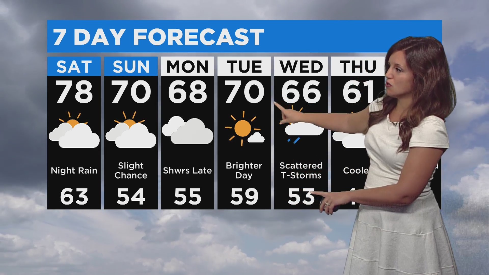
MINNEAPOLIS (WCCO) – Saturday will start out with sunshine and warm temperatures, but there will be a chance for severe weather in the western part of the state in the evening.
High temperatures are forecasted for 78 degrees in the Twin Cities area. The morning will see lots of sun – especially in central and southern Minnesota – but clouds will develop in the afternoon.
In western Minnesota, after an initial bout of rain in the afternoon, there will be a slight chance for severe weather starting around 8 p.m. WCCO meteorologist Katie Steiner says there is a possibility for strong winds and large hail until midnight in areas such as Alexandria and Brainerd.
Credit: CBS
Temperatures will be around 63 degrees overnight, which is very warm for this time of year. Then, a high of 70 degrees is possible in the Twin Cities on Sunday.
Credit: CBS
There is a chance for spotty showers on Sunday, especially in central Minnesota. After that, the rain should clear out until mid-week. Wednesday could see some scattered thunderstorms, and by Thursday, temperatures should be cooler and closer to average.