- Uttarakhand’s Rishikesh receives highest rainfall across country in last 24 hrs Times of India
- Uttarakhand: Rishikesh receives highest rainfall across country in last 24 hours | Mint Mint
- WATCH: Ganga Crosses Danger Mark In Uttarakhand’s Rishikesh and Haridwar Districts | Weather.com The Weather Channel
- Several places have been damaged in the last 48 hours says, Uttarakhand CM Pushkar Singh Dhami Times of India
- Uttarakhand Rain: Alarming surge in Ganga’s water level in Rishikesh due to heavy rainfall| WATCH | Mint Mint
- View Full Coverage on Google News
Tag Archives: rainfall
Seoul flooding: Record rainfall kills at least 8 in South Korean capital as water floods buildings, submerges cars
South Korea’s Interior and Safety Ministry said three of those who died had been trapped in a flooded semi-basement. Nine others were injured and six people remain missing, the ministry said.
Since midnight Monday local time, parts of Seoul saw a total of 422 millimeters (16 inches) of rain, prompting authorities to raise the highest Level 3 emergency alert. The city recorded 141.5 millimeters (5.57 inches) of rain per hour — the highest rate since authorities began keeping records.
Photos from across the city show severe flooding, with people wading across roads up to their thighs in water.
Though floodwaters had largely receded by Tuesday morning, cars and buses were left strewn across roads and sidewalks, blocking morning traffic.
In some parts of Seoul, drains backed up and sent water pouring back into streets and subway stations, according to the Seoul Metro. A number of subway stations were closed due to flooding, with lines temporarily suspended Monday night. As of Tuesday morning, authorities were still working to reopen the stations.
Several regions south of the Han River were worst affected, including the wealthy, modern Gangnam district where some buildings and stores were flooded and lost power.

Around 800 residents were evacuated to schools and gyms or voluntarily sought shelter in local community centers as flooding affected more than 741 houses and shops, according to authorities.
South Korean President Yoon Suk Yeol sent his condolences to the victims on Tuesday, saying he would conduct an on-site inspection and work to prevent additional damage.
He also pointed out the need to review the country’s disaster management system, since extreme and unpredictable weather is expected to become increasingly common due to the climate crisis.
Heavy rain is expected to continue on Tuesday, with up to 100 millimeters (3.9 inches) of rain per hour in some regions, according to the country’s Meteorology Administration.
Parts of Japan also saw downpours on Monday night, with some regions of Hokkaido reporting flooding — but no injuries as of Tuesday. Authorities have warned of the risk of flash floods and landslides.
Additional reporting by CNN’s Jake Kwon and Reuters.
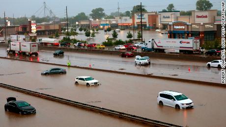
St. Louis flooding: More rain expected Wednesday after record-breaking rainfall turned roads into rivers and forced residents to flee homes barefoot
As the hours stretched on, the rain continued to pour and floodwaters inundated the city and surrounding areas, forcing people to flee or wait for rescue crews to find them.
Jessica Perez was woken by her son at about 3:30 a.m. to find her basement flooded with several inches of water, she told CNN. Video taken by Perez shows the basement blanketed by murky water, soaking the legs of furniture as Christmas ornaments and other items float about.
The water had receded by 9 a.m., revealing a layer of debris and black sludge and leaving everything in the basement ruined, Perez said. “Never in my life have I experienced something like this,” she said.
Between midnight and 7 a.m. Tuesday, more than 8 inches of rain fell on St. Louis, surpassing the city’s 1915 record of 6.85 inches. Though the downpour subsided Tuesday afternoon, the area is expected to receive less severe rainfall Wednesday and Thursday, which could lead to flash flooding in areas that were soaked by Tuesday’s storms, the National Weather Service said.
The flooding left at least one person dead Tuesday. The man’s body was found in a vehicle that had been submerged under more than 8 feet of water, city Fire Chief Dennis Jenkerson said. Police were called to the low-lying area by a concerned resident and found the body when the water receded, he said.
Rescuers fanned out across the area to help stranded residents stuck in the flooding. The fire department responded to about 18 homes where people were trapped, rescuing six people and six dogs, the department said. Approximately 15 people chose to shelter in place.
A state of emergency was declared for the area by St. Louis County Executive Sam Page, which allows the state to ask for federal relief funding, Page said in a tweet. Shelters for displaced residents were set up around the region.
Among those sheltering Tuesday was a family from the suburb of University City, who told CNN affiliate KSDK water was pouring into their home so quickly that they had to flee barefoot, leaving behind medication, walkers and canes. But the items they will mourn the most, they said, are their irreplaceable sentimental belongings, like photos of family members who are no longer living.
Highways turned into rivers
The flooding inundating homes also transformed roads into rushing rivers, forcing multiple street closures as vehicles became submerged window-deep and drivers were left stranded throughout the city, waiting for rescuers on boats.
At one point Tuesday, all four interstate highways heading to downtown St. Louis — I-70, I-64, I-55, and I-44 — had at least one closure because of flooding, KMOV reported.
A stretch of I-70 in the St. Louis area — where vehicles were seen stuck in the water — was closed in both directions during the early morning, and motorists were urged to avoid the interstate.
“You can see there’s cars up there floating around,” driver Jerome Smith said in a video he took while stuck on I-70 for three hours.
By Tuesday afternoon, highways were mostly clear and all bridges over the River des Peres were open, St. Louis Public Safety Director Heather Taylor said. “While we hope the worst is behind us, we want to keep the public informed,” Taylor added.
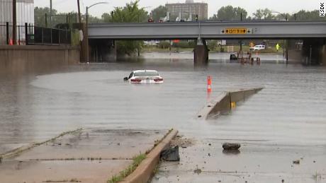
It wasn’t just drivers who saw hourslong delays Tuesday. Parts of the St. Louis area’s MetroLink commuter rail system were flooded, with potential damage to equipment threatening closures more than two weeks long while services are restored, according to the city’s transit agency.
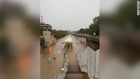
Images showed water rushing through the Forest Park-DeBaliviere Metrolink station. “It’s currently a river … I have never seen this in the four years I’ve lived here,” said Tony Nipert, who lives near the station.
The severe flooding drenching the region also heavily damaged electrical equipment, with thousands of power outages reported in St. Louis County. By the afternoon, power had been restored to nearly 20,000 customers, according to electric power utility Ameren.
Rainfall this intense in the St. Louis area only occurs once every 500 years, on average, according to data from the NWS.
The climate crisis is supercharging rainfall around the world, with climbing temperatures making record-breaking downpours more likely as more moisture is stored in the atmosphere, experts say. Scientists are increasingly confident in the role that the climate crisis plays in extreme weather.
Big one-day precipitation dumps that used to happen once a decade (between 1850 and 1900) are expected to become more common, according to a report from the UN’s Intergovernmental Panel on Climate Change.
CNN’s Amy Simonson, Amy Roberts, Sharif Paget, Sara Smart, Melissa Alonso, Jason Hanna and Caroll Alvarado contributed to this report.
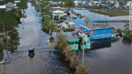
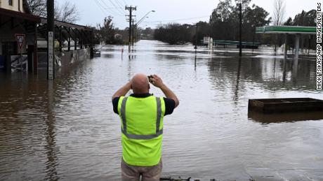
Sydney faces ‘life threatening emergency’ from heavy rainfall
An intense low-pressure system off Australia’s east coast is forecast to bring more heavy rain through Monday across the southern regions of New South Wales even as several places in the state were hit with about a month’s rain over the weekend.
About 100 millimeters (4 inches) of rain could fall in the next 24 hours over a wide swathe of regions in New South Wales, from Newcastle to the south of Sydney, a distance of more than 300 kms (186 miles), the Bureau of Meteorology said.
“If you were safe in 2021, do not assume you will be safe tonight. This is a rapidly evolving situation and we could very well see areas impacted that have never experienced flooding before,” New South Wales emergency services minister Steph Cooke said in a televised media briefing on Sunday evening.
Earlier in the day, she urged people to reconsider holiday travel, with the rough weather having hit at the beginning of school holidays.
“This is a life-threatening emergency situation,” Cooke said.
More than 200 millimeters (8 inches) of rain have fallen over many areas with some hit by as much as 350mm, the Bureau of Meteorology said, warning of flood risks along the Nepean and Hawkesbury Rivers.
Camden in southwest Sydney was underwater, and the weather bureau predicted water levels in the areas of North Richmond and Windsor northwest of Sydney would peak at higher levels than in the past three major flood events since March 2021.
The heavy rains caused Sydney’s main dam to spill early Sunday morning, water authorities said, adding that modeling showed the spill would be comparable to a major spill in March 2021 at the Warragamba Dam.
“There’s no room for the water to remain in the dams. They are starting to spill. The rivers are flowing very fast and very dangerous. And then we have the risk of flash flooding, depending on where the rains are,” State Emergency Service Commissioner Carlene York said.
About 70 evacuation orders are in place in Sydney as authorities urged people to leave their homes before getting stranded without power.
As tens of thousands face evacuation, frustration swelled in North Richmond and Windsor in Sydney’s west after floods submerged homes there for the third time this year.
“We are over it. We are so over it. (This) is a bit much for of us,” a flood-hit Windsor resident told ABC television.
At least 29 people have been rescued from floodwaters, including one who was hanging on to a pole for an hour as workers struggled to reach them.
The body of a man who fell out of a kayak was pulled out of Sydney Harbour, police said, adding that the circumstances were under investigation but appeared to be linked to the windy conditions.
Federal emergency management minister Murray Watt has offered more troops and said on Monday the government has activated the satellite emergency management system to help with the flood relief efforts.
Hawaii weather: Power restored to parts of Honolulu after record rainfall causes flooding
“Hawaiian Electric crews worked throughout the night to restore service to customers in downtown Honolulu and Chinatown and were able to repair one of three transformers damaged by flooding. As a result, power was restored this morning to six buildings, including the State Capitol, state office and city municipal buildings, district court, Central Pacific Bank and First Hawaiian Bank,” the statement said.
Relentless rain in Hawaii left parts of the state under the threat of “significant and life-threatening flooding,” the National Weather Service in Honolulu said Monday night, with some areas already tallying more than a foot of rain over a 48-hour span.
Sheets of drenching rain came down as low-lying roads pooled with water, forcing drivers to navigate the flooded roadways.
There was just too much water at one time, which led to flooding, says KGMB/KHNL reporter Lynn Kawano.
The Honolulu Fire Department (HFD) responded to 90 storm-related incidents between Monday and Tuesday morning after heavy rain flooded parts of Oahu.
According to a press release, most of the calls were for flooded houses, but they received reports of downed trees and power lines and blown-off roofs. Responders rescued 10 people, including five boys, from rushing water in streams.
Monday was the second-wettest day in the history of Honolulu, according to the NWS.

Much of Oahu was hit by up to 2 inches of rain an hour Monday. Honolulu, picked up nearly 8, breaking the record for the wettest December day.
The western Hawaiian Islands of Kauai and Niihau will remain under a flood watch through early Wednesday.
The situation had improved in many areas by later Tuesday, with Oahu dropped from a flood watch.
“Periods of heavy rainfall are possible over Kauai County tonight as a weakening kona low pulls deep tropical moisture over the western end of the island chain,” the NWS says.
Low spots are subject to extreme runoff, which can clog bridges and culverts, exacerbating the already dangerous flooding. Landslides are also expected.

Gov. David Ige declared a state of emergency Monday due to the heavy rains, which he said were “anticipated to continue to cause flooding damage to public and private property.”
The declaration allows the use of funds “to support state and county efforts in providing quick and efficient relief of suffering, damage, and losses caused by flooding and other effects of heavy rains,” Ige said on Twitter.
The dayslong rain event had already left some communities saturated.
Nene Cabin on the Big Island topped the list at 14.07 inches in 48 hours as of Monday night. Keaumo, also on the Big Island, recorded 13.64 inches and Kula on Maui received 12.95 inches.
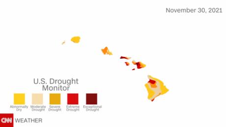
While the rain is creating potentially hazardous conditions, it may also help Hawaii recover from a drought.
More than half of the state, 56%, is under some level of drought and half of Oahu was under severe drought as of November 30. An updated drought report is expected in the coming days.
The threat of flooding comes days after parts of Hawaii were under a blizzard warning over the weekend. High winds and winter weather were seen in mountain summits on the Big Island, the NWS said.
CNN’s Travis Caldwell, Jenn Selva, Kelly McCleary and Claudia Dominguez contributed to this report.
Pacific north-west floods latest: record rainfall leaves at least one dead as Vancouver cut off | World news
The BC Government’s Alert Ready emergency system — which could have sent out a mobile alert to every cell phone in the region, as well as cut into radio and TV broadcasts with the evacuation alert — sat silent.
The government only uses it for tsunamis, so this “catastrophic” event did not qualify.
It was up to the City of Abbotsford to get the word out by itself, with its mayor and local emergency officials holding an impromptu press briefing late Tuesday night on the city’s YouTube channel — the makeshift event a far cry from the enormous reach of the provincial government’s largely quiet communications apparatus…
BC promised to expand the Alert Ready system after the summer’s heat dome killed 595 people, and the government found itself under fire for not doing enough to reach out to people before the emergency started to warn them to seek help in cooling centres.
But then the weekend flooding started, and instead of the broadcast system being ready for prime time it was scheduled to undergo a simple “test” message Wednesday (which was later cancelled after the real emergency started).
The province issued a statement late Tuesday night claiming it was “ready and available to issue a broadcast intrusive alert through the Alert Ready system” but that the “City of Abbotsford has indicated that it does not want to issue an alert at this time.”
300-year-old tree rings confirm recent uptick in hurricane-driven rainfall
Enlarge / Towering longleaf pines in the Green Swamp of North Carolina.
Tropical cyclones like Hurricane Ida can cause severe flooding, producing disruptions, damage, and loss of life. Like many other types of weather, tropical cyclones and hurricanes on the US East Coast have become more extreme over the past several decades. Although there is some controversy over the extent of the increase in intensity, there is evidence that such storms are moving more slowly than in the past. This slower movement causes storms to last longer and produce more rain. However, because conventional weather records only go as far back as 1948, it’s unclear how unusual these slow-moving cyclones are compared to earlier weather patterns.
A recent study addresses this question by using tree rings to reconstruct hundreds of years of seasonal cyclone precipitation levels. The studied trees, some over 300 years old, show that precipitation extremes have been increasing by 2 to 4 mm per decade, resulting in a cumulative increase in rainfall of as much as 128 mm (five inches) compared to the early 1700s. The greatest increases have occurred in the last 60 years, and recent extremes are unmatched by any prior events.
Beyond establishing these reconstructed historical records, researchers are working with these data sets to improve forecasts of what this region might expect in the future.
Good for growth—at least for trees
In an earlier work, Dr. Justin Maxwell and his collaborators found that longleaf pine trees on the East Coast of the US could act as indicators of tropical cyclone precipitation, as measured by the trees’ late season (June to October) growth bands. These smaller, more local studies indicated that recent precipitation levels were far greater than anything the trees had experienced earlier in their lifetimes.
That’s an unexpected finding, since tree-ring records generally show evidence of extreme weather scattered throughout their history, although the frequency may vary. The discovery prompted the new study, which checked whether this pattern held over a wider area.
“Often, tree-ring reconstructions show us that the extreme climate we have recorded with instruments (weather stations) over the last 120 years was surpassed back in time,” Dr. Justin Maxwell told Ars Technica. “Our past research showed that recent extremes were unmatched in the past—all the highest values are mostly since the 1990s, which was a big surprise, and that encouraged us to sample a broader area to see if this increase was local or present over a larger region.”
Combining existing data sets with two new locations, the researchers included trees from a total of seven sites across North and South Carolina. Within North America, this region receives the most rain from tropical cyclones, and it also has the world’s most complete record of this type of precipitation.
The new data sets included a selection of samples from 13–36 old-growth trees per site (taken in a way that caused minimal damage to the trees), as well as stumps. The researchers’ next step was to calibrate their model by comparing tree ring patterns to known rainfall measurements from 1948 to the present.
Reconstructing the past to predict the future
As might be expected, tree rings are more representative of seasonal rainfall than of the frequency or extremity of individual storms. But the growth patterns clearly suggested less cyclone season precipitation in centuries gone by.
A year with a lot of rain doesn’t necessarily mean a giant storm passed through. “[It] could represent rainfall from one hurricane, or it could’ve been multiple hurricanes,” wrote Maxwell. “What we found in this paper is that this area is receiving more tropical cyclone precipitation for the entire season.” While researchers in the field are still debating the cause, many have suggested that it’s related to the trend of storms moving over the area more slowly.
Worldwide, cyclones’ translational speeds have decreased by as much as 10 percent in the last 70 years due to weakening global wind currents. “This [increased precipitation] is because hurricanes are hanging around one area longer than they used to,” Maxwell explained.
The team is expanding its historical reconstruction by including samples from across the southeastern US. The study’s co-author, Dr. Joshua Bregy, is also collaborating with other experts to explore whether these reconstructions can be used to help project what we might expect from future cyclone seasons.
“Based on our current knowledge of the global climate system, in a warmer world, global winds will be weaker, and we are seeing this happen already,” said Maxwell. “If warming continues, as is predicted, these global winds will continue to be weak. Global winds are what steer tropical cyclones, so having weaker winds leads to more meandering storm tracks and stalled storms in one location, producing more rainfall. Therefore, these large seasonal totals of tropical cyclones are likely to continue into the future.”
PNAS, 2021. DOI: 10.1073/pnas.2105636118
K.E.D. Coan is a freelance journalist covering climate and environment stories at Ars Technica. She has a PhD in chemistry and chemical biology.
Santa Rosa at 176% of normal rainfall for this time of year
A band of moisture passed over the San Francisco Bay Area on Wednesday night, bringing showery weather across the region.
A prior system and the lingering showers added up to some rainfall totals that are impressive for mid-October, often a dry month in Northern California.
The National Weather Service said its downtown San Francisco gauge recorded 0.21 inches, and the Oakland gauge 0.11 inches from 5 to 8 p.m.
“It really beefed up when it arrived onshore,” Ryan Walbrun, a forecaster with the weather service, said of the band of moisture that reached San Francisco this evening.
The weather service also noted that in the North Bay, Santa Rosa was running 176% of normal rainfall for the water year that started Oct. 1.
The Santa Rosa Airport recorded 1.41 inches from Oct. 1-20; the normal total for this timeframe is 0.8 inches.
The Bay Area is in the middle of a wet spell, with two weak storms expected to hit the region Thursday night and Saturday night, before a potent atmospheric river delivers a soaking Sunday into Monday. Walbrun said Wednesday night that it remained unclear exactly where the big storm will dump the most rain.
“There’s still uncertainty in where the heaviest bands are going to line up,” Walbrun said. “What’s showing a strong signal is the amount of water vapor that will be possible out of this thing. The worst-case scenarios would be if it stalled somewhere. I think for the Bay Area, this is going to be a beneficial rain. We don’t have the burn scars that some of the other areas have. To get some October rains like this is a good thing overall.”
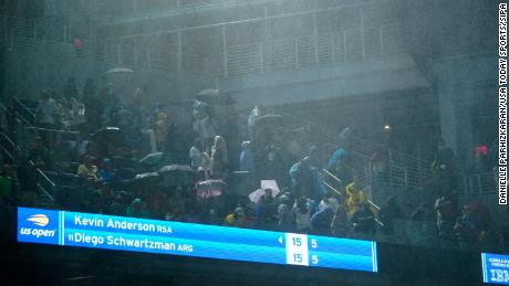
US Open match suspended amid heavy rainfall despite stadium roof
Kevin Anderson and Diego Schwartzman’s second-round singles match was halted early in the second set as water came through multiple openings of the roof on Louis Armstrong Stadium.
The contest was later moved to Arthur Ashe Stadium and ended just after 1 a.m. ET with Schwartzman winning in straight sets 7-6 6-3 6-4.
“Thank you everyone for staying tonight,” Schwartzman said in his on-court interview.
“Crazy weather. (It) was very difficult before the match. We were talking not just because we want to play, (but) also because the security and the government, police, everyone (that) was involved in the decision to come to this court.”
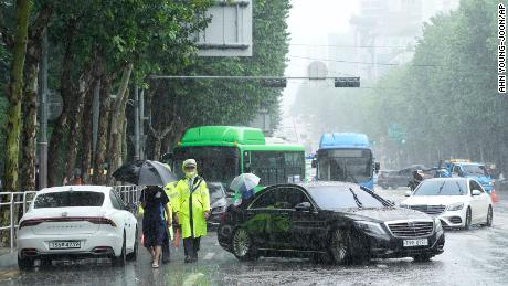
New York City declared a state of emergency early Thursday morning as the Northeast region was hit by strong winds and heavy rainfall.
READ: Tennis’ governing bodies continue to urge players to get vaccinated ahead of US Open
At least 11 people have died in New York City, New Jersey and Maryland as a result of the weather.
Newark, New Jersey experienced its wettest day in recorded history on Wednesday, and Central Park also recorded its wettest hour with 3.15 inches of rain between 8:51 and 9:51 p.m. ET.
As rain descended on Flushing Meadows, fans turned to ponchos and umbrellas to ward off the elements. Blowers were brought on to clear water from the courts and ball kids also mopped the surface with towels.

There were two rain delays in the 108-minute first set between Schwartzman and Anderson before the match was suspended three points into the second set.
It resumed following the conclusion of the match between Stefanos Tsitsipas and Adrian Mannarino on Arthur Ashe, which has a roof.
“I could hear (the rain),” Tsitsipas told reporters after his 6-3 6-4 7-6 6-0 victory. “At first, I thought it was the crowd, people talking on the back seats, but now … I just realized it was not the crowd, it was the rain. Just a lot of noise coming from up there.
“Regardless of that, I do have a bed here so I might have a sleepover here tonight.”
READ: Novak Djokovic thought he heard ‘booing’ at the US Open as he starts his pursuit of history — or did he?

The match between Angelique Kerber and Anhelina Kalinina, scheduled to take place in Louis Armstrong Stadium on Wednesday, was moved to Thursday.
“Crazy rain and flooding in NYC. Stuck at Arthur Ashe stadium… Hope everyone is staying safe,” former ski star Lindsey Vonn wrote on Twitter.
With limited train services running from stations near Flushing Meadows, the United States Tennis Association said it is working with New York authorities to identify routes to get fans home from the venue.
The US Open released a statement on Thursday delaying gate openings and match start times, saying: “The safety of our fans, players and staff is of the utmost importance … The current plan will not open gates before 11:00 am.”
CNN’s Jill Martin contributed to reporting.
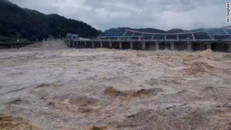
Dubai Tires of Waiting for Rainfall
(Newser)
–
The recent downpours in the United Arab Emirates seemed a little unreal; the country only receives about 4 inches of rain per year. It turns out they weren’t quite natural: Scientists have hit clouds with electronic charges to force rainfall during a heat wave that’s often pushed temperatures in Dubai past 115 degrees. The zaps are delivered by drones, CBS reports. Researchers said the electricity causes droplets to form clumps, making them less likely to evaporate on the way down—a regular outcome where clouds and temperatures are high. The electrical charges don’t present the environment concern that using chemicals in clouds does.
“What we are trying to do is to make the droplets inside the clouds big enough so that when they fall out of the cloud, they survive down to the surface,” said a project staff member, per CNN. The government has posted video of the resulting rain on Instagram. It was so heavy that waterfalls appeared on the side of roads, per Yahoo News, and made driving difficult. Scientists at Britain’s University of Reading developed the technology. After a demonstration there in May, the ambassador to the UK said, “It’s moving to think that the rainfall technology I saw today, which is still being developed, may someday support countries in water-scarce environments like the UAE.” (Read more United Arab Emirates stories.)
var FBAPI = '119343999649';
window.fbAsyncInit = function() { FB.init({ appId: FBAPI, status: true, cookie: true, xfbml: true, oauth: true, authResponse: true, version: 'v2.5' });
FB.Event.subscribe('edge.create', function (response) { AnalyticsCustomEvent('Facebook', 'Like', 'P'); }); };
// Load the SDK asynchronously (function (d, s, id) { var js, fjs = d.getElementsByTagName(s)[0]; if (d.getElementById(id)) return; js = d.createElement(s); js.id = id; js.src = "https://connect.facebook.net/en_US/sdk.js"; fjs.parentNode.insertBefore(js, fjs); }(document, 'script', 'facebook-jssdk'));