Tag Archives: Plates

Watch 1 Billion Years of Shifting Tectonic Plates in 40 Mesmerizing Seconds : ScienceAlert

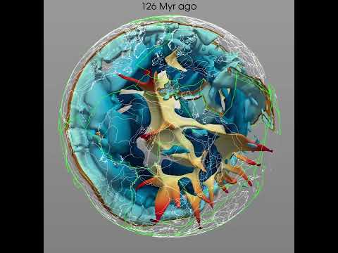
The tectonic plates that cover Earth like a jigsaw puzzle move about as fast as our fingernails grow, but over the course of a billion years that’s enough to travel across the entire planet – as a fascinating video reveals.

In one of the most complete models of tectonic plate movements ever put together, scientists in 2021 condensed 1 billion years of movement into a 40-second video clip, so we can see how these giant slabs of rock have interacted over time.

As they move, the plates affect climate, tidal patterns, animal movements and their evolution, volcanic activity, the production of metals, and more: they’re more than just a covering for the planet, they’re a life support system that affects everything that lives on the surface.

frameborder=”0″ allow=”accelerometer; autoplay; clipboard-write; encrypted-media; gyroscope; picture-in-picture” allowfullscreen>

“For the first time a complete model of tectonics has been built, including all the boundaries,” geoscientist Michael Tetley, who completed his PhD at the University of Sydney, explained to Euronews in 2021.

“On a human timescale, things move in centimeters per year, but as we can see from the animation, the continents have been everywhere in time. A place like Antarctica that we see as a cold, icy inhospitable place today, actually was once quite a nice holiday destination at the equator.”

The moving and sliding of the plates is quite a sight if you check out the video – land masses that are near neighbors become distant cousins and vice versa, and you might be surprised at just how recently it was that the countries and continents settled into the positions that we know today.

Understanding these movements and patterns is crucial if scientists want to predict how habitable our planet will be in the future, and where we’re going to find the metal resources we need to ensure a clean energy future.

Plate movement is estimated through the study of the geological record – the magnetism that provides data on substrates’ historic positions in respect to Earth’s spin axis and the types of material locked in rock samples that help match the pieces of past geological plate puzzles together.

Here the team went to great lengths to choose and combine the most suitable models currently available, looking at both the movements of the continents and the interactions along plate boundaries.

“Planet Earth is incredibly dynamic, with the surface composed of plates that constantly jostle each other in a way unique among the known rocky planets,” said geoscientist Sabin Zahirovic, from the University of Sydney.

“These plates move at the speed fingernails grow, but when a billion years is condensed into 40 seconds a mesmerizing dance is revealed. Oceans open and close, continents disperse and periodically recombine to form immense supercontinents.”

The further scientists go into the past, the more difficult it becomes to estimate how plates have moved, and in this case the Neoproterozoic to Cambrian (1,000 to 520 million years ago) eras in particular were carefully charted and brought in line to match the more modern records that we have.

Questions remain about how these plates first formed and when this formation happened, but every new data point helps us to understand the ancient history of Earth – even accounting for missing plates in some models.

The scientists admit that their work lacks some finer detail – stretched as it is across the entire planet and a billion years – but they’re hoping that it can act as a useful resource and foundation for the future study of these movements and the impact they have on everything else on the planet.

“Our team has created an entirely new model of Earth evolution over the last billion years,” said geoscientist Dietmar Müller from the University of Sydney.

“Our planet is unique in the way that it hosts life. But this is only possible because geological processes, like plate tectonics, provide a planetary life-support system.”

The research has been published in Earth-Science Reviews.

An earlier version of this article was published in February 2021.

Read original article here

Kosovo-Serbia tensions over license plates: What to know as NATO monitors dispute

Comment

Kosovo and Serbia — two Balkan countries that fought a bloody war in the 1990s and have been living in uneasy coexistence ever since — are once again at odds, this time over moves by Kosovo to force ethnic Serbs living in its northern regions to obtain license plates issued by Kosovar authorities.

The seemingly mundane move is anything but, as the status of ethnic Serbs living near the border between Serbia and Kosovo is at the heart of a protracted conflict between the two governments. Kosovo declared its independence from Serbia in February 2008, but Serbia still considers Kosovo its province.

“The overall security situation in the Northern municipalities of Kosovo is tense,” NATO’s peacekeeping force in Kosovo said Sunday in a statement. Serbian President Aleksandar Vucic said, “We have never been in a more difficult situation.”

What are the tensions in Kosovo about?

The latest flare-up in tensions is tied to new rules over license plates and cross-border travel documents.

Under new regulations that were meant to take effect on Aug. 1, ethnic Serbs living in villages in northern Kosovo would have had to apply for license plates issued by Kosovar authorities for their vehicles. Since the 1998-99 war, some in that population had used Serbian license plates with a different status. Authorities in Kosovo tolerated the dual-track system to preserve the peace but said last year they would no longer do so.

Another rule would have forced Serbian nationals visiting Kosovo to get an additional entry-exit document from Kosovar authorities at the border. Previously, they could enter without it. Serbia imposes a similar rule on Kosovars seeking to cross its borders.

Kosovo-Serbia tensions flare; NATO peacekeepers track border protests

The government in Kosovo’s capital, Pristina, has been trying for years to assert full institutional control over the ethnic Serb-majority areas of northern Kosovo, but it has faced fierce resistance from residents who still consider their communities part of Serbia.

On Sunday, ethnic Serbs blockaded roads in northern Kosovo to protest the new rules, forcing Kosovar authorities to shut down two border crossings, Jarinje and Brnjak. Kosovar police said shots were fired in their direction during the protests, although no one was hurt, Reuters reported.

Belgrade argues that the new rules violate a 2011 agreement on freedom of movement between Kosovo and Serbia.

Kosovo’s allies, including the United States and European Union, called for calm and urged Pristina to delay implementation of the new rules. Late on Sunday, Kosovo agreed to a 30-day delay if all roadblocks were removed. Albin Kurti, Kosovo’s prime minister, accused the protesters of trying to “destabilize” Kosovo and charged that Serbia was orchestrating “aggressive acts” during the protests.

Josep Borrell, the E.U.’s top diplomat, welcomed Kosovo’s decision to postpone the new measures until Sept. 1 and said he expects “all roadblocks to be removed immediately.”

How is this related to the Serbia-Kosovo conflict?

The roots of the conflict between Serbia and Kosovo go back to the breakup of Yugoslavia in the early 2000s, which itself followed a drawn-out period of ethnic conflicts between the Yugoslav republics in the 1990s. Serbia and Kosovo fought a brutal war between 1998 and 1999 that ended with the involvement of NATO in a U.S.-backed bombing campaign against Serbian territory.

Serbia is a majority Orthodox Christian nation, but Kosovo — previously a province of Yugoslavia — is dominated by ethnic Albanians, who are largely Muslim, in addition to a minority of ethnic Serbs. Tensions flared between the groups, particularly over moves in 1989 by Yugoslav President Slobodan Milosevic, a nationalist Serb, to abrogate the autonomy of Kosovo enshrined in the Yugoslav constitution.

In response, Kosovar militants formed the Kosovo Liberation Army and staged attacks against Serbia in the following years as they pushed for the creation of a new state encompassing the region’s ethnic Albanian minorities. Members of the Kosovo Liberation Army were also accused of committing war crimes against ethnic Serbs in Kosovo and those they viewed as collaborators.

Authorities in Belgrade violently cracked down on the Albanian population of Kosovo, viewing them as supportive of the KLA and its separatist attacks. More than 1 million Kosovar Albanians were driven from their homes.

Western countries and NATO became involved, bringing the parties together in France in February 1999 to negotiate a truce. While the Kosovar side agreed to a truce, Yugoslavia — which by then encompassed only Serbia and Montenegro — did not. Atrocities committed against Kosovar Albanians continued in what the U.S. State Department at the time called a “systematic campaign” by “Serbian forces and paramilitaries” to “ethnically cleanse Kosovo.”

In response, NATO launched a devastating 11-week bombing campaign against Yugoslavia that ended in June 1999, when the country signed an agreement with NATO to allow a peacekeeping force into Kosovo.

Why is NATO in Kosovo, and what is its mandate?

NATO has had a peacekeeping force in Kosovo — Kosovo Force, or KFOR — since June 1999. The creation of the force was approved by a U.N. Security Council resolution.

KFOR’s initial goal was to prevent conflict from restarting between ethnic Serbs and Albanians after NATO and Yugoslavia signed a peace agreement allowing for the return of ethnic Albanians displaced by the war.

Since then, the force has gradually been reduced, from roughly 50,000 troops to fewer than 4,000 today. In its own words, it works to maintain security and stability in the region, support humanitarian groups and civil society, train and support the Kosovo Security Force and “support the development of a stable, democratic, multi-ethnic and peaceful Kosovo.”

In its statement about the protests in Kosovo on Sunday, KFOR said it was “monitoring” the situation and was “prepared to intervene if stability is jeopardized.”

How is this related to the Russia-Ukraine war?

The Balkans have not escaped the reverberations of the war in Ukraine.

Kosovo has supported Ukraine since Russia’s invasion, which Kurti, the prime minister, called “an attack against us all.” Ukraine has not recognized Kosovo’s independence.

Russia — a long-standing ally of Serbia — does not recognize Kosovo as an independent state, either, and has echoed Serbia’s president in blaming the government in Pristina for the renewed tensions in northern Kosovo.

Maria Zakharova, a spokeswoman for Russia’s Foreign Ministry, accused Kosovo on Sunday of using the new licensing laws and ID documents to discriminate against the Serbian population.

“We call on Pristina and the United States and the European Union backing it to stop provocation and observe the Serbs’ rights in Kosovo,” she said, according to Russia’s official Tass news agency.

Russian President Vladimir Putin has cited Kosovo to justify his recognition of two separatist provinces in the Donbas region of eastern Ukraine. “Very many states of the West recognized [Kosovo] as an independent state,” Putin told U.N. chief António Guterres when the two met in April. “We did the same in respect of the republics of Donbas.”

Rachel Pannett and Ishaan Tharoor contributed to this report.


Read original article here

The Mars Express Delivers Truly Epic Views of The Solar System’s Biggest Canyon

The biggest known canyon in the Solar System is getting the star treatment in new images from the European Space Agency’s Mars Express orbiter.

As it whooshed by in Martian orbit, the spacecraft captured a pair of gouges in the planet’s surface that make up part of the Valles Marineris, a system of canyons known as the Grand Canyon of Mars.


The Martian Grand Canyon, however, makes the Earth version seem like a canyon for ants.

At 4,000 kilometers (2,485 miles) long and 200 miles wide, Valles Marineris is almost 10 times longer and 20 times wider than the vast canyon system found in North America. Earth has nothing that comes even close to comparing to Valles Marineris, which makes the feature intensely interesting to planetary scientists.

The segment images by Mars Express include sections of two chasmata, Ius on the left and Tithonium on the right. Close study of the details of these incredible natural structures can help scientists understand Mars’ geology and geological history.

The location of the two chasmata. (NASA/MGS/MOLA Science Team)

For example, Mars seems to be tectonically extinct now, with its crust fused into one discrete layer that encases the planetary interior. This is in contrast to Earth, the crust of which is divided into plates that can shift around, with a whole range of consequences.

Valles Marineris, scientists think, formed back when Mars did have tectonic plates. Recent research has proposed that the canyon system formed as the result of a widening crack between plates, a long time ago. This makes Valles Marineris very interesting indeed.


The images from Mars Express make the canyon look relatively shallow, but the two chasmata are incredibly large; the full resolution version is approximately 25 kilometers per pixel. Ius Chasma extends 840 kilometers in length in its entirety, and Tithonium Chasma 805 kilometers.

The orbiter is also equipped with 3D imaging capabilities, which reveal that, in this image, the canyon reaches about as deep as it can – around 7 kilometers, five times deeper than the Grand Canyon.

The topography of the two chasmata. (ESA/DLR/FU Berlin)

There are several features of note that the images reveal in the two chasmata. Within Ius, a row of jagged mountains probably formed as the two tectonic plates pulled apart. As that was some time ago, these mountains are pretty eroded.

Tithonium is partially colored a darker hue in the top part of the image. This may have come from the nearby Tharsis volcanic region to the west of the chasma. Paler mounds arise from within this dark sand; these are actually mountains that stand more than 3 kilometers tall.

However, the mountains’ tops have been scoured off thanks to erosion. This suggests that whatever material the mountain is made of is softer and weaker than the rock around it.

That rock isn’t impervious, either, though. To the lower right of the more visible of the mountains, features suggest a recent landslide of the canyon wall to the right.

An annotated map showing various features in the chasmata. (ESA/DLR/FU Berlin)

Interestingly, Mars Express has detected sulfate-bearing minerals in some of the features within Tithonium Chasma. This has been interpreted as evidence that the Chasma was once (at least partially) filled with water.

The evidence is far from conclusive, but recent detections of hydrogen in the chasma suggest that a lot of water may be bound up with minerals beneath the surface.


As with most Mars science, it’s difficult to make conclusions with any certainty, since we are forced – currently, at least – to study it remotely. But identifying areas of interest could help in the planning of future Mars missions, both crewed and uncrewed; sending a rover to Valles Marineris would certainly aid scientists in answering some of the burning questions that have arisen.

Images like these are scientifically useful because they help formulate and sometimes answer those questions. But they’re also just spectacularly gorgeous.

The images have been published on the ESA website.


Read original article here

Updated Maps of Tectonic Plates

New tectonic plate model with boundary zones in darker shading. Credit: Dr. Derrick Hasterok, University of Adelaide

New models that show how the continents were assembled are providing fresh insights into the history of the Earth and will help provide a better understanding of natural hazards like earthquakes and volcanoes.

“We looked at the current knowledge of the configuration of plate boundary zones and the past construction of the continental crust,” said Dr. Derrick Hasterok, Lecturer, Department of Earth Sciences, University of Adelaide who led the team that produced the new models.

“The continents were assembled a few pieces at a time, a bit like a jigsaw, but each time the puzzle was finished it was cut up and reorganized to produce a new picture. Our study helps illuminate the various components so geologists can piece together the previous images.

“We found that plate boundary zones account for nearly 16 percent of the Earth’s crust and an even higher proportion, 27 percent, of continents.”

“Our new model for tectonic plates better explains the spatial distribution of 90 per cent of earthquakes and 80 per cent of volcanoes from the past two million years whereas existing models only capture 65 percent of earthquakes.”

Dr. Derrick Hasterok, Lecturer, Department of Earth Sciences, University of Adelaide


New models showing the Earth’s architecture. Credit: Dr. Derrick Hasterok, University of Adelaide

The team produced three new geological models: a plate model, a province model, and an orogeny model.

“There are 26 orogenies – the process of mountain formation – that have left an imprint on the present-day architecture of the crust. Many of these, but not all, are related to the formation of supercontinents,” said Dr. Hasterok.

“Our work allows us to update maps of tectonic plates and the formation of continents that are found in classroom textbooks. These plate models which have been assembled from topographic models and global seismicity, have not been updated since 2003.”

The new plate model includes several new microplates including the Macquarie microplate which sits south of Tasmania and the Capricorn microplate which separates the Indian and Australian plates.

“To further enrich the model, we added more accurate information about the boundaries of deformation zones: previous models showed these as discrete areas rather than wide zones,” said Dr. Hasterok.

“The biggest changes to the plate model have been in western North America, which often has the boundary with the Pacific Plate drawn as the San Andreas and Queen Charlotte Faults. But the newly delineated boundary is much wider, approximately 1500 km, than the previously drawn narrow zone.

“The other large change is in central Asia. The new model now includes all the deformation zones north of India as the plate bulldozes its way into Eurasia.”


A tale told by the continents. Credit: Dr. Derrick Hasterok, University of Adelaide

Published in the journal Earth-Science Reviews, the team’s work provides a more accurate representation of the Earth’s architecture and has other important applications.

“Our new model for tectonic plates better explains the spatial distribution of 90 percent of earthquakes and 80 percent of volcanoes from the past two million years whereas existing models only capture 65 percent of earthquakes,” said Dr. Hasterok.

“The plate model can be used to improve models of risks from geohazards; the orogeny model helps understand the geodynamic systems and better model Earth’s evolution and the province model can be used to improve prospecting for minerals.”

Reference: “New Maps of Global Geological Provinces and Tectonic Plates” by Derrick Hasterok, Jacqueline A. Halpin, Alan S. Collins, Martin Hand, Corné Kreemer, Matthew G. Gard and Stijn Glorie, 31 May 2022, Earth-Science Reviews.
DOI: 10.1016/j.earscirev.2022.104069

The work included researchers at the Universities of Adelaide, Tasmania, Nevada-Reno, and Geoscience Australia.


Read original article here

Two Giant Blobs Lurk Deep Inside Earth, And It Looks Like They’re Shape-Shifters

Deep in the Earth beneath us lie two blobs the size of continents. One is under Africa, the other under the Pacific Ocean.

The blobs have their roots 2,900 km (1,800 miles) below the surface, almost halfway to the centre of the Earth. They are thought to be the birthplace of rising columns of hot rock called “deep mantle plumes” that reach Earth’s surface.


When these plumes first reach the surface, giant volcanic eruptions occur – the kind that contributed to the extinction of the dinosaurs 65.5 million years ago. The blobs may also control the eruption of a kind of rock called kimberlite, which brings diamonds from depths 120-150 km (and in some cases up to around 800 km) to Earth’s surface.

Scientists have known the blobs existed for a long time, but how they have behaved over Earth’s history has been an open question. In new research, we modeled a billion years of geological history and discovered the blobs gather together and break apart much like continents and supercontinents.

(Ömer Bodur)

Above: Earth’s blobs as imaged from seismic data. The African blob is at the top and the Pacific blob at the bottom.

A model for Earth blob evolution

The blobs are in the mantle, the thick layer of hot rock between Earth’s crust and its core. The mantle is solid but slowly flows over long timescales. We know the blobs are there because they slow down waves caused by earthquakes, which suggests the blobs are hotter than their surroundings.

Scientists generally agree the blobs are linked to the movement of tectonic plates at Earth’s surface. However, how the blobs have changed over the course of Earth’s history has puzzled them.


One school of thought has been that the present blobs have acted as anchors, locked in place for hundreds of millions of years while other rock moves around them. However, we know tectonic plates and mantle plumes move over time, and research suggests the shape of the blobs is changing.

Our new research shows Earth’s blobs have changed shape and location far more than previously thought. In fact, over history they have assembled and broken up in the same way that continents and supercontinents have at Earth’s surface.

We used Australia’s National Computational Infrastructure to run advanced computer simulations of how Earth’s mantle has flowed over a billion years.

These models are based on reconstructing the movements of tectonic plates. When plates push into one another, the ocean floor is pushed down between them in a process known as subduction.

The cold rock from the ocean floor sinks deeper and deeper into the mantle, and once it reaches a depth of about 2,000 km it pushes the hot blobs aside.

Above: The past 200 million years of Earth’s interior. Hot structures are in yellow to red (darker is shallower) and cold structures in blue (darker is deeper).

We found that just like continents, the blobs can assemble – forming “superblobs” as in the current configuration – and break up over time.


A key aspect of our models is that although the blobs change position and shape over time, they still fit the pattern of volcanic and kimberlite eruptions recorded at Earth’s surface. This pattern was previously a key argument for the blobs as unmoving “anchors”.

Strikingly, our models reveal the African blob assembled as recently as 60 million years ago – in stark contrast to previous suggestions the blob could have existed in roughly its present form for nearly ten times as long.

Remaining questions about the blobs

How did the blobs originate? What exactly are they made of? We still don’t know.

The blobs may be denser than the surrounding mantle, and as such they could consist of material separated out from the rest of the mantle early in Earth’s history. This could explain why the mineral composition of the Earth is different from that expected from models based on the composition of meteorites.

Alternatively, the density of the blobs could be explained by the accumulation of dense oceanic material from slabs of rock pushed down by tectonic plate movement.


Regardless of this debate, our work shows sinking slabs are more likely to transport fragments of continents to the African blob than to the Pacific blob.

Interestingly, this result is consistent with recent work suggesting the source of mantle plumes rising from the African blob contains continental material, whereas plumes rising from the Pacific blob do not.

Tracking the blobs to find minerals and diamonds

While our work addresses fundamental questions about the evolution of our planet, it also has practical applications.

Our models provide a framework to more accurately target the location of minerals associated with mantle upwelling. This includes diamonds brought up to the surface by kimberlites that seem to be associated with the blobs.

Magmatic sulfide deposits, which are the world’s primary reserve of nickel, are also associated with mantle plumes. By helping target minerals such as nickel (an essential ingredient of lithium-ion batteries and other renewable energy technologies) our models can contribute to the transition to a low-emission economy.

Nicolas Flament, Senior Lecturer, University of Wollongong; Andrew Merdith, Research fellow, University of Leeds; Ömer F. Bodur, Postdoctoral research fellow, University of Wollongong, and Simon Williams, Research Fellow, Northwest University, Xi’an.

This article is republished from The Conversation under a Creative Commons license. Read the original article.


Read original article here

New model of a fundamental process behind the movement of Earth’s tectonic plates

Pacific Ring of Fire. Credit: Gringer (talk) 23:52, 10 February 2009 (UTC), Public domain, via Wikimedia Commons

A research team from University of Lisbon (Portugal) and Johannes Gutenberg University (Germany) has developed for the first time an advanced numerical model of one of the main processes behind the movement of Earth’s tectonic plates.

The tectonic plates that form the Earth’s surface are like puzzle pieces that are in constant, very slow motion—on average, they move only up to around 10 centimeters a year. But these puzzle pieces don’t quite fit together: there are zones on one plate that end up plunging under another—the so-called subduction zones, central to the dynamics of the planet. This movement is slow, but it can lead to moments of great energy release and, over thousands of years, large mountain ranges or marine trenches are formed in these regions.

How do these subduction zones originate, and how do they evolve over time? Geologists already knew that in these zones, on a time scale of thousands of years, this process can stagnate and reverse itself, giving rise to new subduction zones. But it was still necessary to know how this happens, and to include in the models the various (and enormous) forces involved in this process. For the first time, it was possible to simulate in three dimensions one of the most common processes of formation of new subduction zones, ensuring that all forces are dynamically and realistically modeled, including Earth’s own gravity.

“Subduction zones are one of the main features of our planet and the main driver of plate tectonics and the global dynamics of the planet. Subduction zones are also the places where earthquakes of great magnitude occur, as is the case of the Pacific Ring of Fire, the largest system of subduction zones in the world. For this reason, it is extremely important to understand how new subduction zones start and how this process takes place”, explains Jaime Almeida, first author of this study, researcher at Instituto Dom Luiz, at Faculty of Sciences of the University of Lisbon (Ciências ULisboa).

Formation of the Vanuatu subduction zone. Credit: Communications Earth & Environment (2022). DOI: 10.1038/s43247-022-00380-2

Each of the simulations that led to these results took up to a week to process on a supercomputer at the Johannes Gutenberg University (Germany). But it could have taken weeks, or even months, to run on this supercomputer—had it not been for the computational code recent developed at this University, significantly more efficient than other available codes.

“It had already been theoretically proposed that new subduction zones were more likely to form from pre-existing ones, but models of this kind had never been carried out. In a way, it seems to be easier and more likely than anticipated”, explains João Duarte, researcher at Instituto Dom Luiz and co-author of this study, now published in the Communications Earth and Environment journal.

This model opens up a new range of perspectives and represents the starting point for studying specific regions of our planet: “We are now applying these models to specific cases, such as the subduction zones that are starting in the Atlantic Ocean, in the Caribbean, the Scotia Arc, next to Antarctica, and on the Southwest Portuguese margin, and which could lead to the closing of the Atlantic Ocean. The 1755 Lisbon earthquake may have been the harbinger of the beginning of subduction on our margin, and there are marine geology data that support it”, concludes João Duarte.


Unearthing the cause of slow seismic waves in subduction zones


More information:
Jaime Almeida et al, Self-replicating subduction zone initiation by polarity reversal, Communications Earth & Environment (2022). DOI: 10.1038/s43247-022-00380-2

Provided by
University of Lisbon

Citation:
New model of a fundamental process behind the movement of Earth’s tectonic plates (2022, March 11)
retrieved 12 March 2022
from https://phys.org/news/2022-03-fundamental-movement-earth-tectonic-plates.html

This document is subject to copyright. Apart from any fair dealing for the purpose of private study or research, no
part may be reproduced without the written permission. The content is provided for information purposes only.


Read original article here

Titans RB Derrick Henry to play vs. Bengals with metal plates in foot, shoe

Derrick Henry is back, officially activated and set to start for the Titans. Take out the hoopla of one of the NFL’s best players making a dramatic return for the playoffs, and the King will be essentially back to normal.

With one minor exception: “I have a big steel plate in my foot,” Henry said this week.

That’s right. The player who was an MVP candidate before breaking the fifth metatarsal in his foot and having surgery had a steel plate inserted into his foot. That’s not all.

Henry is also expected to play in Saturday’s Divisional Round against the Bengals with a metal plate in his shoe, similar to those that players who have turf toe wear. Added protection.

The metal plate is a modified orthotic to protect the foot from stress and stop it from flexing. It takes pressure off the repaired area to keep it safe while he’s running and cutting. He can run without any reservations.

As for the plate, it’s considered more secure and stable than simply inserting a screw into the repaired metatarsal. Henry actually has one plate and five screws in his foot.

Eleven weeks out from surgery, Henry is close to full go. The bone is almost completely healed, and it is considered strong enough to withstand the constant pressure he’ll put on it today.

Henry hasn’t played since Oct. 31, when he unknowingly broke his foot versus the Colts and still had 28 carries. Dr. Norman Waldrop and Dr. Lyle Cain at the Andrews Sports Medicine & Orthopedic Center performed the surgery soon after and eyes were set on a return this season.

“This has never happened to me in my whole career,” Henry said this week. “I was just like, ‘Well, can’t do nothing about it now.’ Try to get surgery and start the recovery process and try to get back as quick as I can.”

Henry is listed at 6-foot-3, 247 pounds, and he’s basically at his weight right now. After extensive rehab that included plenty of training and cardio work, he’s in top physical form. One person who saw him in practice this week simply stated, “He looked great; you know he’s a freak.”

The hope is that the adrenaline from the return overwhelms any nerves or trepidation with being back. Henry won’t be on a snap count, but they will keep an eye on him. Judging from the flow of the game, the Titans may have D’Onta Foreman play a slightly larger role than usual or at least spell Henry so it’s not too many snaps in a row.

But basically, Henry is back.

“You definitely appreciate this game a lot more when you are away from it,” Henry told reporters. “Being away from your teammates and having that comradery, going to work every day and going out and playing on Sundays each and every week, you definitely miss that. Just happy to be back.”

Read original article here

Sony Threatens Dbrand With Legal Action Over Black PS5 Plates

Image: Dbrand

You might not remember since February 2021 was actually 19 years ago, but earlier this year phone and console skin makers Dbrand released a set of black PS5 faceplates. Not content with merely releasing them, though, the company also bizarrely baited Sony to sue them, and Sony is now obliging.

A page from Dbrand’s site that knew this day was coming
Image: Dbrand

As The Verge report, Dbrand’s “Darkplates” have recently been removed from the company’s store, and any purchasing links now redirect to a page that only lists all the news articles written about the plates, including the Gizmodo story linked above.

Why pull them now? Because the company received a cease & desist letter from Sony, part of which says:

It has come to SIE’s attention that dbrand has been promoting and selling console accessories in a manner that is deeply concerning to our client. First, dbrand is selling faceplates for the PSS console (in both standard edition and digital edition configurations) that replicate SIE’s protected product design. Any faceplates that take the form of our client’s PSS product configuration, or any similar configuration, and are: produced and sold without permission from SIE violate our client’s intellectual property rights in the distinctive console design.

Second, dbrand is selling skins for SIE devices that feature the PlayStation Family Mark Your company may not sell products that bear unauthorized depictions of our client’s PlayStation Marks. The below still from one of dbrand’s instructional videos shows a dbrand skin bearing a design identical to the PlayStation Family Mark.

For their part, Dbrand have responded with a rambling corporate shitpost on Reddit, which opens with “much like your hopes and dreams, Darkplates are dead” before eventually settling into actual legal defences of their position, saying the plates don’t violate any existing trademarks. Dbrand suspects that Sony’s actual motivation here is moving to shut down competitors before revealing its own, first-party replacement panels for the PS5.

Note that this isn’t the first company Sony has gone after like this. CustomizeMyPlates were also forced to halt sales of their own coloured replacement plates in 2020, though in their case they resumed sales earlier this year and have been undisturbed since, perhaps because their versions don’t include tiny logos that look a lot like actual PlayStation icons.

Read original article here

Removing the %&*@ from Maine’s vanity plates will take time

Removing the flipping obscenities from license plates on Maine’s roads and highways isn’t going to happen overnight, even though a law banning such profanities in a state where such regulation has been unusually lax goes into effect Monday.

Currently, there are license plates with salty language including f-bombs, references to anatomy and sex acts, and general insults. One license plate says simply, “F—-Y0U” — except that on the plate, it’s plainly spelled out.

Now, rule-making is getting underway to ensure the law protects First Amendment rights while getting rid of obscene language.

The process, which includes public comment, could take between two to four months, Secretary of State Shenna Bellows said.

Requests for so-called vanity license plates that are deemed to be potentially offensive will be on hold in the meantime. Eventually, the state will begin recalling previously issued plates, likely this winter.

“Rule-making will delay the process of active removal of plates from the road but will help us balance the free speech rights of citizens and the public interest of removing inappropriate license plates,” she said.

A majority of states have restrictions on license plate messages that are considered profane, sexually suggestive, racist, drug related, politically objectionable or religiously offensive.

But Maine became the “wild, wild, wild west of vanity license plates” when the state dropped its review process in 2015. “Our anything-goes approach was unusual,” Bellows said.

As a former executive director of the American Civil Liberties Union of Maine, Bellows understands the importance of the First Amendment protections on free speech. But she acknowledged she didn’t understand the extent of “really disturbing” license plates before she was sworn in as secretary of state earlier this year.

There have been lawsuits over the issue in other states.

Last year, a federal judge ruled that California couldn’t enforce a ban on vanity license plates it considers “offensive to good taste and decency.”

The California law was overly broad, so states must be careful to target license plates that are profane or obscene, or represent hate speech.

In Maine, there are about 121,000 vanity license plates on the roads in a state with about 1.3 million residents. An estimated 400 offensive plates could be subject to recall, officials said.

Bellows said she’s looking at it this way: “If you can’t say it on the 6 o’clock news, it shouldn’t be on a license plate.”

“The license plate is the property of the state,” she said. “If you really want an offensive slogan on your car, then you can use a bumper sticker.”

Read original article here

Dbrand starts selling matte black PS5 plates and dares Sony to sue

It’s fair to say the PlayStation 5’s huge, two-tone industrial design is not for everyone, and now Dbrand says it has a solution. The company best known for its custom phone skins and cases has put “Darkplates” on sale, with the promise that the precisely carved slabs of plastic will turn your PS5 into a murdered-out matte-black hunk of hardware.

This isn’t just an unofficial accessory — Dbrand is actively encouraging Sony to sue it for putting the product out. The background there is that a small company, first called PlateStation5 then CustomizeMyPlates, was forced to cancel and refund orders for a similar product last year following legal action from Sony. Now Dbrand’s order page reads “Go ahead, sue us” at the top.

The goading doesn’t stop there. Dbrand’s Darkplate features a texture somewhat inspired by the PlayStation button icons microtexture found on the PS5 and its controller. The company describes it as “a familiar-but-legally-distinct apocalyptic spin on the classic PlayStation button shapes.”

The Darkplate also has an optional skin for the glossy black middle section of the PS5, in case you want to customize its color or just make it less of a breeding ground for fingerprints. Beyond the matte black option, there are plain yellow and white skins as well as patterns like “robot camo” and “redcode.”

Converting your PS5 to matte black won’t be particularly cheap and might not be all that quick. One set of plates sells for $49 plus shipping, while adding a middle skin takes the base price up to $60.95. All three waves of product set to ship in February, March, and April respectively have sold out in the past couple of hours, while a fourth wave for May is now available for backorder. The PS5 Digital Edition version of the plates, meanwhile, hasn’t yet been put on sale at all.

Read original article here

The Ultimate News Site