Tag Archives: eruption

Long-Dormant Volcano in Iceland Awakens in Fiery Eruption

A volcano erupted near Iceland’s capital Reykjavík on Friday, shooting up a fountain of lava that lit the night sky following thousands of small earthquakes in recent weeks.
Photo: Halldor Kolbeins/AFP (Getty Images)

A long-dormant volcano erupted on Iceland’s Reykjanes Peninsula on Friday, shooting a fountain of lava that lit the night sky roughly 19 miles (30 kilometers) southwest of the nation’s capital, the Icelandic Meteorological Office reported Friday. The eruption, estimated to be the peninsula’s first in almost 800 years, follows weeks of increased seismic activity in the region.

“The eruption is considered small at this stage and the eruptive fissure is app. 500 m [546 yards] long. The magma area is app. 1km2. [0.4 square miles],” the IMO said in a tweet. “Lava fountains are small.”

The agency later tweeted a video of the eruption’s aftermath taken from a Coast Guard helicopter, which you can check out in all its terrifying glory below.

The eruption occurred near the Fagradalsfjall mountain and began around 4:45 p.m. ET on Friday, blasting lava up to 109 yards (100 meters) into the air, Bjarki Friis of Iceland’s meteorological office told Reuters. The IMO first spotted the eruption with a webcam it installed close to the mountain, which it then confirmed via thermal satellite imagery. Hours later, the agency said the lava appeared to be flowing “slowly to the southwest and west.” The glow of the lava could be seen from the outskirts of Iceland’s capital city, Reykjavík.

While local authorities said they didn’t believe the eruption poses an immediate threat to nearby towns, they advised residents to close their windows and stay indoors to avoid potentially inhaling volcanic gas ejected from the fissure. The Icelandic police also urged people to stay away from the eruption site for the time being as first responders continue to assess the situation.

More than 40,000 earthquakes have hit the region in the past four weeks, Reuters reports. The peninsula saw roughly 400 earthquakes on Thursday morning alone, and several low-frequency earthquakes were recorded below Fagradalsfjall earlier in the day on Friday, according to the IMO.

Iceland is one of the most volcanic nations in the world. Of its approximately 130 volcanoes, roughly 30 remain active. The Reykjanes Peninsula has remained relatively calm after sputtering on and off in a series of major eruptions between the 10th and 13th centuries, but scientists began bracing for potential eruptions after the region’s rate of earthquakes sharply increased in 2019.


Read original article here

U. research finds central Utah volcanoes are still active, but no evidence of imminent eruption

SALT LAKE CITY — University of Utah researchers say an unusual sequence of earthquakes that happened in central Utah in 2018 and 2019 are a reminder of Utah’s old volcanoes in the area are active. Luckily, they say there’s no indication of an imminent eruption.

The research, which was first published in Geophysical Research Letters last month, centered around a pair of peculiar earthquake sequences in the Black Rock Desert near Fillmore. One of the central Utah earthquakes happened on Sept. 12, 2018, and the other happened on April 14, 2019. The quakes registered as 4.0 and 4.1 in magnitude, respectively, and produced several aftershocks.

The location of both earthquakes was the Black Rock Desert volcanic field that’s located in central Utah between I-15 and the Utah-Nevada state line. The volcanic area last erupted approximately 720 years ago, resulting in basalt cinder cones and flows by Ice Springs, according to the U.S. Geological Survey.

In addition to the earthquakes being detected by the Utah Regional Seismic Network, they were captured by temporary seismic equipment that was being used less than 20 miles from the desert to monitor a geothermal well for a different project.

A team of researchers from the University of Utah, USGS and the University of Iowa went to work analyzing the data. The temporary equipment helped detect 35 aftershocks after the 2019 quake, which was nearly double what the normal system detected.

They found that the earthquake was 1½ miles below the surface, which is pretty shallow for earthquakes. For example, the 5.7 magnitude earthquake that rattled the Wasatch Front last year happened about 6 miles below the earth’s surface; the 2018 and 2019 central Utah earthquakes were unrelated to the Magna earthquake, Utah’s largest since 1992.

A map of the Black Rock Desert volcanic field. The orange triangles show the location of University of Utah Seismograph Stations and the black dots show the locations of Utah earthquakes. (Photo: University of Utah)

In addition, the earthquakes didn’t produce “shear waves,” which are common for earthquakes in Utah. The frequency of the seismic energy was also much lower than the typical Utah earthquakes, Maria Mesimeri, a postdoctoral research associate for University of Utah Seismograph Stations and the study’s lead author, said in a news release Tuesday.

“Because these earthquakes were so shallow, we could measure surface deformation (due to the quakes) using satellites, which is very unusual for earthquakes this small,” she said.

The data led researchers to believe that the earthquakes weren’t caused by colliding faults like most Utah earthquakes; rather, they said their research indicated these quakes were the result of ongoing activity in the volcanic field underneath the desert.

Mesimeri said it’s likely both earthquakes may have been caused by either magma or heated water that made its way closer to the surface and caused the earthquakes.

“Our findings suggest that the system is still active and that the earthquakes were probably the result of fluid-related movement in the general area,” she said. “The earthquakes could be the result of the fluid squeezing through rock or the result of deformation from fluid movement that stressed the surface faults.”

The good news, she added, is there is no reason to believe the recent earthquakes are warning signs of an imminent eruption. It just means it’s a location that researchers may want to pay attention to more intently.

Related Stories

More stories you may be interested in

Read original article here

17,000 earthquakes hit Iceland in the past week. An eruption could be imminent

The largest quake, a magnitude 5.6 on the Richter scale, occurred on the morning of February 24. It was the loudest in a swarm that continues to rattle residents in the nearby capital city of Reykjavík and the municipalities around it, where two-thirds of the Icelandic population lives. Two larger earthquakes — over magnitude 5.0 — also hit on February 27 and March 1.

The quakes have caused little damage so far, though Iceland’s Road and Coastal Administration has reported small cracks in roads in the area and rockfalls on steep slopes near the epicenter of the swarm.

“I have experienced earthquakes before but never so many in a row,” Reykjavik resident Auður Alfa Ólafsdóttir told CNN. “It is very unusual to feel the Earth shake 24 hours a day for a whole week. It makes you feel very small and powerless against nature.”

In the fishing town of Grindavík, locals have had a front-row seat to the tremors. “I’ve not experienced anything like this before,” says Páll Valur Björnsson, who teaches at the local College of Fisheries and sits as a deputy member of Parliament.

“We are used to it; it started one year ago. But it is much more now — very unsettling. I’m not afraid but this is uncomfortable. I woke up twice last night because of [tremors]. There was a very big one when I went to sleep, and I woke up with one. It is difficult but you have to learn to live with it,” he said.

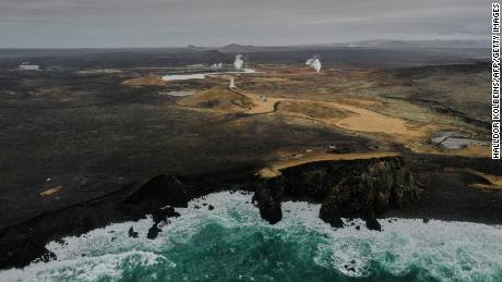
Iceland sits on a tectonic plate boundary that continually splits apart, pushing North America and Eurasia away from each other along the line of the Mid-Atlantic Ridge. Most seismic activity here is only picked up by sensitive scientific equipment. Occasional stronger tremors are an inevitable part of living in an active seismic region.

Only this time, there seems to be no end to the rumble under the ground.

Þorvaldur Þórðarson, a professor of volcanology at the University of Iceland, said concerns over the recent activity are understandable. “Of course it worries people. For this region, this is actually fairly unusual, not because of the type of earthquakes or their intensity, but for their duration. It’s been going for more than a week now.”

“We are battling with the ‘why’ at the moment. Why is this happening? It is very likely that we have an intrusion of magma into the [Earth’s] crust there. It has definitely moved closer to the surface, but we are trying to figure out if it’s moving even closer to it,” he said. With multiple volcanoes in the area, local officials have warned that an eruption could be imminent.

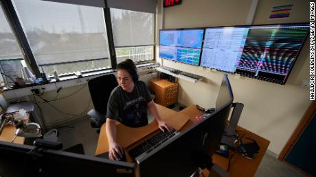
Elísabet Pálmadóttir, specialist in natural hazards at the Icelandic Meteorological Office, told CNN that authorities are deploying surveillance equipment in the area, from GPS and earthquake monitors to web cameras and gas detectors.

She too can’t remember having ever experienced so many earthquakes over such a long period of time. She warns that a more powerful event could be cause for concern, and estimates that the area could experience a magnitude 6 earthquake or above.

“In this particular area, where we’ve seen activity in the past week, we could experience a magnitude 6.0 earthquake. But we could have a 6.5 to the east of the area, east of the Kleifarvatn Lake,” she says.

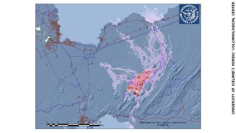
No towns appear to be at risk from lava flows in the event of a volcanic eruption, according to the latest modeling by the University of Iceland’s Volcanology and Natural Hazard Group, which released maps of potential flows on Wednesday.

“Based on the current model, no major town is in harm’s way,” volcanologist Ármann Höskuldsson told CNN, adding that Keflavík International Airport — one of the most direct connections between Iceland and the rest of the world — would also be spared.

However, the main road connecting the airport to the capital, Reykjavík, could be impacted, as could some powerlines, he added.

Pálmadóttir notes that such models do not account for possible dangerous gases that could be emitted from a volcanic eruption.

The specter of a major eruption recalls the Eyjafjallajökull eruption in 2010, which caused one of the world’s largest air-traffic shutdowns since World War II. But Pálmadóttir says a similar ash plume would be unlikely in the current situation.

Þórðarson adds that “the magma composition here is very different, the intensity of explosive activity would be significantly less.”

On Wednesday afternoon, a tremor close to the Keilir volcano, just 20 miles south of the capital, prompted authorities to ban traffic in the area. On its webpage, the Icelandic MET Office says similar activity has previously preceded eruptions.

Víðir Reynisson, Chief Superintendent at Iceland’s Department for Civil Protection and Emergency Management, told a news conference on Wednesday that an eruption was “more likely than not” within the next few hours. It would be the first in the area since the 12th century.

For now, residents await signs of an eruption, some with excitement, others with anxiety. Víkurfréttir, a local news service, has installed a video camera pointing at Keilir, which will start livestreaming should an eruption start.

In the last 24 hours, the large earthquakes felt the previous days have largely subsided — but the current lull may not last for long. “It’s definitely not over,” says Pálmadóttir.

Read original article here

Mount Etna’s recent eruption is a spectacular volcanic show

Mount Etna, the volcano that towers over eastern Sicily, evokes superlatives. It is Europe’s most active volcano and also the continent’s largest.

And the fiery, noisy show of power it puts on for days or weeks, even years every so often, is always super spectacular. Fortunately, Etna’s latest eruption captivating the world’s attention has caused neither injuries nor evacuation.

But each time it roars back into dramatic action, it wows onlookers and awes geologists who spend their careers monitoring its every quiver, rumble and belch.

CLICK HERE TO SIGN UP FOR OUR LIFESTYLE NEWSLETTER

A fiery river of glowing lava flows on the north-east side of the Mt Etna volcano engulfed with ashes and smoke near Milo, Sicily, Wednesday night, Feb. 24, 2021.  (AP Photo/Salvatore Allegra)

WHAT’S HAPPENING NOW?

On Feb. 16, Etna erupted, sending up high fountains of lava, which rolled down the mountain’s eastern slope toward the uninhabited Bove Valley, which is five kilometers (three miles) wide and eight kilometers (five miles) long. The volcano has belched out ash and lava stones that showered the southern side.

The activity has been continuing since, in bursts more or less intense. The flaming lava lights up the night sky in shocking hues of orange and red. There’s no telling how long this round of exciting activity will last, say volcanologists who work at the Etna Observatory run by the National Institute of Geophysics and Volcanology.

While public fascination began with the first dramatic images this month, the explosive activity began in September 2019, becoming much stronger two months ago. The current activity principally involves the south-east crater, which was created in 1971 from a series of fractures.

A fiery river of glowing lava flows on the north-east side of the Mt Etna volcano near Milo, Sicily, Wednesday night, Feb. 24, 2021. (AP Photo/Salvatore Allegra)

HARD TO MISS

Etna towers 3,350 meters (around 11,050 feet) above sea level and is 35 kilometers (22 miles) in diameter, although the volcanic activity has changed the mountain’s height over time.

Occasionally, the airport at Catania, eastern Sicily’s largest city, has to close down for hours or days, when ash in the air makes flying in the area dangerous. Early in this recent spell of eruptive activity, the airport closed briefly.

But for pilots and passengers flying to and from Catania at night when the volcano is calmer, a glimpse of fiery red in the dark sky makes for an exciting sight.

Lava and smoke are belched out from a crater as seen from the north-east side of the Mt Etna volcano near Milo, Sicily, Wednesday night, Feb. 24, 2021.  (AP Photo/Salvatore Allegra)

LIVING WITH A VOLCANO

With Etna’s lava flows largely contained to its uninhabited slopes, life goes in towns and villages elsewhere on the mountain. Sometimes, like in recent days, lava stones rain down on streets, bounce off cars and rattle roofs.

But many residents generally find that a small inconvenience when weighted against the benefits the volcano brings. Lava flows have left fertile farmland. Apple and citrus trees flourish. Etna red and whites are some of Sicily’s most popular wines, from grapes grown on the volcanic slopes.

Tourism rakes in revenues. Hikers and backpackers enjoy views of the oft-puffing mountain and the sparkling Ionian Sea below. For skiers who want uncrowded slopes, Etna’s a favorite.

FOLLOW US ON FACEBOOK FOR MORE FOX LIFESTYLE NEWS

Glowing lava is seen from the north-east side of the Mt Etna volcano engulfed with ashes and smoke near Milo, Sicily, Wednesday night, Feb. 24, 2021.  (AP Photo/Salvatore Allegra)

IT CAN BE DEADLY

Inspiring ancient Greek legends, Etna has had scores of known eruptions in its history. An eruption in 396 B.C. has been credited with keeping the army of Carthage at bay.

In 1669, in what has been considered the volcano’s worst known eruption, lava buried a swath of Catania, about 23 kilometers (15 miles) away and devastated dozens of villages. An eruption in 1928 cut off a rail route circling the mountain’s base.

More recently, in 1983, dynamite was used to divert lava threatening inhabited areas. In 1992, the army built an earthen wall to contain the lava, flowing from Etna for months, from hitting Zafferana Etnea, a village of a few thousand people. At one point, the smoking lava stopped two kilometers (just over a mile) from the edge of town.

Over the last century, a hiccup in geological time, low-energy explosive eruptions and lava flows, both fed from the summit and side vents, have characterized Etna.

Read original article here

Indonesian volcano unleashes river of lava in new eruption

Indonesia’s most active volcano erupted Wednesday with a river of lava and searing gas clouds flowing 1,600 meters (5,250 feet) down its slopes.

It was Mount Merapi’s biggest lava flow since authorities raised its danger level in November, said Hanik Humaida, the head of Yogyakarta’s Volcanology and Geological Hazard Mitigation Center.

After morning rain, ashfall turned into muck in several villages, where the sound of eruption could be heard 30 kilometers (18 miles away). Police and rescue services told miners to cease work along rivers but no one was evacuated.

INDONESIA’S MOST VOLATILE VOLCANO SPEWS ASH IN NEW ERUPTION

A volunteer uses his walkie-talkie as he monitors Mount Merapi during an eruption in Sleman, Wednesday, Jan. 27, 2021. Indonesia’s most active volcano erupted Wednesday with a river of lava and searing gas clouds flowing 1,500 meters (4,900 feet) down its slopes. (AP Photo/Slamet Riyadi)

Authorities in November had evacuated nearly 2,000 people living on the mountain in Magelang and Sleman districts on Java Island but most have since returned.

The alert was being maintained at the second-highest level and authorities told people to stay out of the existing 5-kilometer (3-mile) danger zone around the crater as the local administrations in Central Java and Yogyakarta provinces closely monitor the situation.

HAWAII VOLCANO ERUPTION FORMS LAVA LAKE, CAN BE SEEN FROM SPACE

The 2,968-meter (9,737-foot) volcano is on the densely populated island of Java and near the ancient city of Yogyakarta. It is the most active of dozens of Indonesian volcanoes and has repeatedly erupted with lava and gas clouds recently.

Merapi’s last major eruption in 2010 killed 347 people.

CLICK HERE TO GET THE FOX NEWS APP

Indonesia, an archipelago of 270 million people, is prone to earthquakes and volcanic activity because it sits along the Pacific “Ring of Fire,” a horseshoe-shaped series of seismic fault lines around the ocean.

Read original article here

Indonesian volcano unleashes river of lava in new eruption

YOGYAKARTA, Indonesia (AP) — Indonesia’s most active volcano erupted Wednesday with a river of lava and searing gas clouds flowing 1,500 meters (4,900 feet) down its slopes.

It was Mount Merapi’s biggest lava flow since authorities raised its danger level in November, said Hanik Humaida, the head of Yogyakarta’s Volcanology and Geological Hazard Mitigation Center.

Authorities in November had evacuated nearly 2,000 people living on the mountain in Magelang and Sleman districts on Java Island but most have since returned. There has been no new evacuation.

The alert was being maintained at the second-highest level and authorities told people to stay out of the existing 5-kilometer (3-mile) danger zone around the crater as the local administrations in Central Java and Yogyakarta provinces closely monitor the situation.

The 2,968-meter (9,737-foot) volcano is on the densely populated island of Java and near the ancient city of Yogyakarta. It is the most active of dozens of Indonesian volcanoes and has repeatedly erupted with lava and gas clouds recently.

Merapi’s last major eruption in 2010 killed 347 people.

Indonesia, an archipelago of 270 million people, is prone to earthquakes and volcanic activity because it sits along the Pacific “Ring of Fire,” a horseshoe-shaped series of seismic fault lines around the ocean.

Read original article here