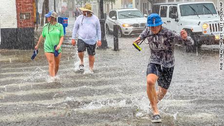
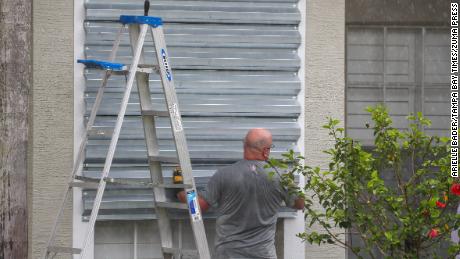
Do you see storm damage? Share your photos and videos in our Facebook groupTropical Storm Elsa has moved out of the region, but it left a mark on southeast Georgia and on the Lowcountry with wind damage, multiple tornado reports and flooding rain Wednesday night and early Thursday morning.Update 7:43 a.m.:Dominion Energy is reporting several thousand power outages in Beaufort County alone, the vast majority of which are located in the northern part of the county.Meanwhile, Georgia Power is reporting 200-300 outages just in the Savannah area.Beaufort County Schools has closed facilities and canceled summer school for the day.Update 1:27 a.m.:The National Weather Service has expired the tornado warning for Charleston County and the storm continues to move further away from the WJCL viewing area.Update 1:15 a.m.:The National Weather Service says there are reports coming in of damage in Port Royal, South Carolina. Here are some pictures from storm spotters that were following Elsa’s track.Update 1:13 a.m.:The National Weather Service says a tornado has been confirmed located over Meggett, moving north at 45 mph.Update 1:02 a.m.:The National Weather Service says a tornado has been confirmed located over Edisto Island moving north at 50 mph. But the good news for the WJCL coverage area is that Elsa is making an exit.Update 12:59 a.m.:The National Weather Service has issued a tornado warning for Charleston County until 1:30 a.m. A severe thunderstorm capable of producing a tornado was located over Edisto Island moving north at 50 mph.Update 12:56 a.m.:The National Weather Service will allow the tornado warning for Beaufort and Colleton counties to expire at 1 a.m. There are multiple reports coming in from the Port Royal area of storm damage, including trees on houses, power lines down and power outages.Update 12:49 a.m.:Check out the below video as Frank Sulkowski provides a report from Tybee Island.Meanwhile, power outages are being reported on Hilton Head.And there were some high wind gusts measured off Forest Beach and Hilton Head.Update 12:38 a.m.:The National Weather Service says a severe thunderstorm capable of producing a tornado was located over Green Pond, South Carolina, and was moving north at 40 mph.Update 12:23 a.m.:The National Weather Service has issued a tornado warning for Beaufort and Colleton counties until 1 a.m. A severe thunderstorm capable of producing a tornado was located near Dale, moving northwest at 50 mph.Update 12:05 a.m.:The National Weather Service will let the tornado warning for Hilton Head Island, Beaufort and Port Royal, South Carolina, expire at 12:15 a.m. Thursday morning. The NWS said the Hilton Head Airport reported a gust of 43 mph during the window when the tornado warning was in effect. Update 11:57 p.m.The National Weather Service has canceled the tornado warning for Screven County in Georgia. However, the tornado warning remains for Hilton Head Island, Beaufort and Port Royal, South Carolina until 12:15 a.m.Update 11:50 p.m.:The National Weather Service says a severe thunderstorm capable of producing a tornado was located over Parris Island moving northwest at 40 mph.Update 11:40 p.m.The National Weather Service has issued a tornado warning for Hilton Head Island, Beaufort and Port Royal, South Carolina until 12:15 a.m. There is also a tornado warning for Screven County until midnight. Update 11:25 p.m.:The National Weather Service in Charleston has issued a Severe Thunderstorm Warning for Beaufort, Colleton and Jasper counties in South Carolina until 12:30 a.m. Thursday. The impacted areas include Hilton Head, Bluffton and Beaufort in South Carolina.Update 11:05 p.m.:Georgia Power is reporting more than 9,000 customers are now without power because of the impacts from Tropical Storm Elsa. Most of the impacted customers are in the downtown Savannah area. Plus, the National Weather Service reported a 74 mph wind gust on Tybee Island at 11:02 p.m.Update 10:52 p.m.:The National Weather Service has continued the Tropical Storm warning for Charleston Harbor, coastal waters from Edisto Beach, South Carolina, to Savannah, coastal waters from Savannah to Altamaha Sound, Georgia until further notice.The peak wind gust so far in Savannah has been 44 mph, per the NWS.Update 10:50 p.m.:Check out the below video as Frank Sulkowski provides a report from Tybee Island. Update 10:45 p.m.:More stunning images continue to come in from Eagle Hammock RV Park in Georgia, where the National Weather Service says a tornado left damage in its wake. RVs and trucks are seen flipped over in these photos shared by Michael Lucas.Update 10:30 p.m.:The National Weather Service in Charleston has continued the tornado watch until 5 a.m. Thursday for Allendale, Beaufort, Berkeley, Charleston, Colleton, Dorchester, Hampson counties in South Carolina and Bryan, Bulloch, Candler, Chatham, Effingham, Jenkins and Screven counties in Georgia. The good news is that the NWS has canceled the watch for Evans, Liberty, McIntosh, and Tattnall counties.Update 10:25 p.m.:Riley Miller was live at Shelter Cove as the Lowcountry feels the effects of Elsa.Update 10:20 p.m.:Georgia Power is reporting more than 3,400 customers are now without power because of the impacts from Tropical Storm Elsa. The Savannah area is now being impacted by tropical-storm-force wind gusts of more than 40 mph.Update 10 p.m.:Tropical-storm-force winds have arrived in the region. There are now reports of 40 mph winds at the Savannah/Hilton Head International Airport.Update 9:26 p.m.:Check out the below video as Frank Sulkowski provides a report from Tybee Island. Plus, WJCL Meteorologist Victoria Kokinos says the heaviest rainbands are starting to arrive in Chatham County.Update 9 p.m.:The heaviest band of rain is now lifting north towards Richmond Hill and Savannah, while areas to the south have been pounded with more than 5 inches of rain.Update 8:45 p.m.:See Chief Meteorologist Jeremy Nelson’s latest update in the above video.According to Kings Bay Public Affairs Specialist Chris Tucker, about 10 people have been injured due to the tornado in the St. Marys area.Nine of the 10 have been taken to the hospital but injuries do not appear life-threatening. All those injured were at the RV park, which is on the installation.As many as 12 RVs have been destroyed, but the full extent of the damage is still being assessed. But there has been no reported damage to military equipment or assets. Update 8:35 p.m.:WJCL’s Brooke Butler did a Facebook Live update from Darien, Ga. Watch it in its entirety below.Update 8:25 p.m.:Camden County EMA confirms a tornado touched down in downtown St. Marys. Officials say the area is unsafe and are asking people to avoid the area. If you live in the area, they say to shelter in place until conditions are safe.Update 8:13 p.m.:The latest look at Hilton Head Island:Update 7:25 p.m.:The National Weather Service has issued a widespread tornado watch spanning much of the Lowcountry and Coastal Georgia, until 5 a.m.Update 6:56 p.m.:Check out the below videos as Frank Sulkowski provides a report from Tybee Island and Amy Zimmer has a look at current conditions on Hilton Head Island.Update 6:50 p.m.:Frank Sulkowski reports there are a few power outages on Tybee Island.Update 6:33 p.m.: The National Weather Service has canceled the tornado warning for Wayne County. Conditions still continue to be favorable for spin-up tornadoes as the outer bands of Tropical Storm Elsa move into the Lowcountry.Update 6:30 p.m.:Frank Sulkowski has the latest update from Tybee Island.Update 6:16 p.m.:The National Weather Service has issued a Tornado Warning for Wayne County, Georgia, until 6:45 p.m. The storm is west of Brunswick and is moving to the north at 50 mph. The NWS said the storm is completely rain-wrapped. Watch WJCL’s live storm coverage above.Update 5:47 p.m.:An update from Brooke Butler on the conditions in Darien as Tropical Storm Elsa approaches. Update 5:30 p.m.:Coligny Beach is starting to empty as Elsa continues to move toward the region. Update 5:15 p.m.:Winds are starting to pick up with a 28 mph gust reported in Savannah in the last few minutes. Peak wind gusts will occur between 9 p.m. and 2 a.m. Thursday morning. WJCL Chief Meteorologist Jeremy Nelson shared the latest forecast track from the 5 p.m. advisory as Elsa continues to move toward the region. Update 5 p.m.:Watch live coverage above.Update 4:53 p.m.:A tornado has been confirmed in Jacksonville, Fla.Update 4:30 p.m.:The tornado warning has expired. Watch coverage of the warning in the below video.Update 4:05 p.m.:A tornado warning has been issued in Bulloch and Candler counties until 4:30 p.m.Update 12:45 p.m.:A Tornado Watch has been issued for Bryan, Bulloch, Candler, Chatham, Effingham, Evans, Liberty, Long, McIntosh, Tattnall, Appling, Ware, Wayne and Pierce counties until 8 p.m.Update 12:27 p.m.:See the latest forecast in the video above.Update 11:32 a.m.:Elsa has reportedly made landfall in the north Florida Gulf Coast, in Taylor County.At 11 a.m. on Wednesday, the center of Tropical Storm Elsa was located 65 miles north northwest of Cedar Key. Elsa is moving north at 14 mph with maximum sustained winds at 65 mph.Update 10 a.m.: See Jonathan Myers’ Facebook Live update in the above videoInitial report:Now’s the time to watch “From the Eye of the Storm” as Tropical Storm Elsa is tracking north just off the west coast of Florida. Tropical storm warnings extend into Georgia and South Carolina’s Lowcountry.Elsa is currently a tropical storm and is forecast to make landfall Wednesday morning along the west coast of Florida. The storm will turn northeast and take aim at southeast Georgia and the Lowcountry late this afternoon into early Thursday morning.Weather conditions locally will go downhill after 3 pm. The likely impacts will be heavy rain, gusty winds, and isolated tornadoes.Today is a WJCL 22 Severe High Impact Weather Day. Heavy downpours and localized street flooding are the greatest concerns locally. A widespread 1-3″ of rain is likely, with some locations pick up 5″ or more. Winds may gust to 30-40 mph at times, with gusts around 50mph possible at the coast. You can head here to get your game plan in place now with the free StormTracker22 Hurricane Essential Guide.Stay on top of the very latest Certified Most Accurate forecast by downloading our free WJCLNews App here.
Do you see storm damage? Share your photos and videos in our Facebook group
Tropical Storm Elsa has moved out of the region, but it left a mark on southeast Georgia and on the Lowcountry with wind damage, multiple tornado reports and flooding rain Wednesday night and early Thursday morning.
Update 7:43 a.m.:
Dominion Energy is reporting several thousand power outages in Beaufort County alone, the vast majority of which are located in the northern part of the county.
Meanwhile, Georgia Power is reporting 200-300 outages just in the Savannah area.
Beaufort County Schools has closed facilities and canceled summer school for the day.
This content is imported from Twitter.
You may be able to find the same content in another format, or you may be able to find more information, at their web site.
Update 1:27 a.m.:
The National Weather Service has expired the tornado warning for Charleston County and the storm continues to move further away from the WJCL viewing area.
Update 1:15 a.m.:
The National Weather Service says there are reports coming in of damage in Port Royal, South Carolina. Here are some pictures from storm spotters that were following Elsa’s track.
This content is imported from Twitter.
You may be able to find the same content in another format, or you may be able to find more information, at their web site.
Update 1:13 a.m.:
The National Weather Service says a tornado has been confirmed located over Meggett, moving north at 45 mph.
Update 1:02 a.m.:
The National Weather Service says a tornado has been confirmed located over Edisto Island moving north at 50 mph. But the good news for the WJCL coverage area is that Elsa is making an exit.
This content is imported from Twitter.
You may be able to find the same content in another format, or you may be able to find more information, at their web site.
Update 12:59 a.m.:
The National Weather Service has issued a tornado warning for Charleston County until 1:30 a.m. A severe thunderstorm capable of producing a tornado was located over Edisto Island moving north at 50 mph.
Update 12:56 a.m.:
The National Weather Service will allow the tornado warning for Beaufort and Colleton counties to expire at 1 a.m. There are multiple reports coming in from the Port Royal area of storm damage, including trees on houses, power lines down and power outages.
This content is imported from Twitter.
You may be able to find the same content in another format, or you may be able to find more information, at their web site.
Update 12:49 a.m.:
This content is imported from Twitter.
You may be able to find the same content in another format, or you may be able to find more information, at their web site.
Meanwhile, power outages are being reported on Hilton Head.
This content is imported from Twitter.
You may be able to find the same content in another format, or you may be able to find more information, at their web site.
And there were some high wind gusts measured off Forest Beach and Hilton Head.
This content is imported from Twitter.
You may be able to find the same content in another format, or you may be able to find more information, at their web site.
Update 12:38 a.m.:
The National Weather Service says a severe thunderstorm capable of producing a tornado was located over Green Pond, South Carolina, and was moving north at 40 mph.
Update 12:23 a.m.:
The National Weather Service has issued a tornado warning for Beaufort and Colleton counties until 1 a.m. A severe thunderstorm capable of producing a tornado was located near Dale, moving northwest at 50 mph.
Update 12:05 a.m.:
The National Weather Service will let the tornado warning for Hilton Head Island, Beaufort and Port Royal, South Carolina, expire at 12:15 a.m. Thursday morning. The NWS said the Hilton Head Airport reported a gust of 43 mph during the window when the tornado warning was in effect.
This content is imported from Facebook.
You may be able to find the same content in another format, or you may be able to find more information, at their web site.
Update 11:57 p.m.
The National Weather Service has canceled the tornado warning for Screven County in Georgia. However, the tornado warning remains for Hilton Head Island, Beaufort and Port Royal, South Carolina until 12:15 a.m.
Update 11:50 p.m.:
The National Weather Service says a severe thunderstorm capable of producing a tornado was located over Parris Island moving northwest at 40 mph.
Update 11:40 p.m.
The National Weather Service has issued a tornado warning for Hilton Head Island, Beaufort and Port Royal, South Carolina until 12:15 a.m. There is also a tornado warning for Screven County until midnight.
Update 11:25 p.m.:
The National Weather Service in Charleston has issued a Severe Thunderstorm Warning for Beaufort, Colleton and Jasper counties in South Carolina until 12:30 a.m. Thursday. The impacted areas include Hilton Head, Bluffton and Beaufort in South Carolina.
This content is imported from Twitter.
You may be able to find the same content in another format, or you may be able to find more information, at their web site.
Update 11:05 p.m.:
Georgia Power is reporting more than 9,000 customers are now without power because of the impacts from Tropical Storm Elsa. Most of the impacted customers are in the downtown Savannah area.
Plus, the National Weather Service reported a 74 mph wind gust on Tybee Island at 11:02 p.m.
Update 10:52 p.m.:
The National Weather Service has continued the Tropical Storm warning for Charleston Harbor, coastal waters from Edisto Beach, South Carolina, to Savannah, coastal waters from Savannah to Altamaha Sound, Georgia until further notice.
This content is imported from Twitter.
You may be able to find the same content in another format, or you may be able to find more information, at their web site.
The peak wind gust so far in Savannah has been 44 mph, per the NWS.
Update 10:50 p.m.:
Check out the below video as Frank Sulkowski provides a report from Tybee Island.
This content is imported from Twitter.
You may be able to find the same content in another format, or you may be able to find more information, at their web site.
Update 10:45 p.m.:
More stunning images continue to come in from Eagle Hammock RV Park in Georgia, where the National Weather Service says a tornado left damage in its wake. RVs and trucks are seen flipped over in these photos shared by Michael Lucas.
Update 10:30 p.m.:
The National Weather Service in Charleston has continued the tornado watch until 5 a.m. Thursday for Allendale, Beaufort, Berkeley, Charleston, Colleton, Dorchester, Hampson counties in South Carolina and Bryan, Bulloch, Candler, Chatham, Effingham, Jenkins and Screven counties in Georgia.
The good news is that the NWS has canceled the watch for Evans, Liberty, McIntosh, and Tattnall counties.
Update 10:25 p.m.:
Riley Miller was live at Shelter Cove as the Lowcountry feels the effects of Elsa.
This content is imported from Facebook.
You may be able to find the same content in another format, or you may be able to find more information, at their web site.
Update 10:20 p.m.:
Georgia Power is reporting more than 3,400 customers are now without power because of the impacts from Tropical Storm Elsa. The Savannah area is now being impacted by tropical-storm-force wind gusts of more than 40 mph.
This content is imported from Twitter.
You may be able to find the same content in another format, or you may be able to find more information, at their web site.
Update 10 p.m.:
Tropical-storm-force winds have arrived in the region. There are now reports of 40 mph winds at the Savannah/Hilton Head International Airport.
Update 9:26 p.m.:
Check out the below video as Frank Sulkowski provides a report from Tybee Island. Plus, WJCL Meteorologist Victoria Kokinos says the heaviest rainbands are starting to arrive in Chatham County.
This content is imported from Twitter.
You may be able to find the same content in another format, or you may be able to find more information, at their web site.
This content is imported from Twitter.
You may be able to find the same content in another format, or you may be able to find more information, at their web site.
Update 9 p.m.:
The heaviest band of rain is now lifting north towards Richmond Hill and Savannah, while areas to the south have been pounded with more than 5 inches of rain.
Update 8:45 p.m.:
See Chief Meteorologist Jeremy Nelson’s latest update in the above video.
According to Kings Bay Public Affairs Specialist Chris Tucker, about 10 people have been injured due to the tornado in the St. Marys area.
Nine of the 10 have been taken to the hospital but injuries do not appear life-threatening. All those injured were at the RV park, which is on the installation.
As many as 12 RVs have been destroyed, but the full extent of the damage is still being assessed. But there has been no reported damage to military equipment or assets.
Update 8:35 p.m.:
WJCL’s Brooke Butler did a Facebook Live update from Darien, Ga. Watch it in its entirety below.
Update 8:25 p.m.:
Camden County EMA confirms a tornado touched down in downtown St. Marys. Officials say the area is unsafe and are asking people to avoid the area. If you live in the area, they say to shelter in place until conditions are safe.
This content is imported from Twitter.
You may be able to find the same content in another format, or you may be able to find more information, at their web site.
Update 8:13 p.m.:
The latest look at Hilton Head Island:
Update 7:25 p.m.:
The National Weather Service has issued a widespread tornado watch spanning much of the Lowcountry and Coastal Georgia, until 5 a.m.
ABC
Tornado Watch until 5:00 am Thursday
Update 6:56 p.m.:
Check out the below videos as Frank Sulkowski provides a report from Tybee Island and Amy Zimmer has a look at current conditions on Hilton Head Island.
Update 6:50 p.m.:
Frank Sulkowski reports there are a few power outages on Tybee Island.
This content is imported from Twitter.
You may be able to find the same content in another format, or you may be able to find more information, at their web site.
Update 6:33 p.m.:
The National Weather Service has canceled the tornado warning for Wayne County. Conditions still continue to be favorable for spin-up tornadoes as the outer bands of Tropical Storm Elsa move into the Lowcountry.
Update 6:30 p.m.:
Frank Sulkowski has the latest update from Tybee Island.
This content is imported from Twitter.
You may be able to find the same content in another format, or you may be able to find more information, at their web site.
Update 6:16 p.m.:
The National Weather Service has issued a Tornado Warning for Wayne County, Georgia, until 6:45 p.m. The storm is west of Brunswick and is moving to the north at 50 mph. The NWS said the storm is completely rain-wrapped. Watch WJCL’s live storm coverage above.
Update 5:47 p.m.:
An update from Brooke Butler on the conditions in Darien as Tropical Storm Elsa approaches.
This content is imported from Twitter.
You may be able to find the same content in another format, or you may be able to find more information, at their web site.
Update 5:30 p.m.:
Coligny Beach is starting to empty as Elsa continues to move toward the region.
This content is imported from Facebook.
You may be able to find the same content in another format, or you may be able to find more information, at their web site.
Update 5:15 p.m.:
Winds are starting to pick up with a 28 mph gust reported in Savannah in the last few minutes. Peak wind gusts will occur between 9 p.m. and 2 a.m. Thursday morning.
This content is imported from Twitter.
You may be able to find the same content in another format, or you may be able to find more information, at their web site.
WJCL Chief Meteorologist Jeremy Nelson shared the latest forecast track from the 5 p.m. advisory as Elsa continues to move toward the region.
This content is imported from Twitter.
You may be able to find the same content in another format, or you may be able to find more information, at their web site.
Update 5 p.m.:
Watch live coverage above.
Update 4:53 p.m.:
A tornado has been confirmed in Jacksonville, Fla.
Update 4:30 p.m.:
The tornado warning has expired. Watch coverage of the warning in the below video.
Update 4:05 p.m.:
A tornado warning has been issued in Bulloch and Candler counties until 4:30 p.m.
Update 12:45 p.m.:
A Tornado Watch has been issued for Bryan, Bulloch, Candler, Chatham, Effingham, Evans, Liberty, Long, McIntosh, Tattnall, Appling, Ware, Wayne and Pierce counties until 8 p.m.
This content is imported from Twitter.
You may be able to find the same content in another format, or you may be able to find more information, at their web site.
Update 12:27 p.m.:
See the latest forecast in the video above.
Update 11:32 a.m.:
Elsa has reportedly made landfall in the north Florida Gulf Coast, in Taylor County.
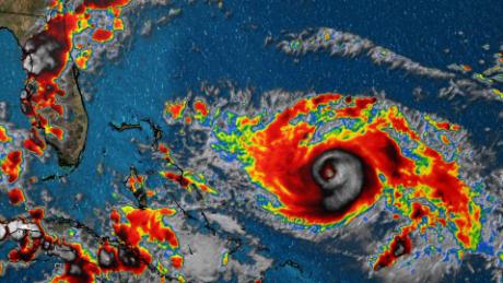
At 11 a.m. on Wednesday, the center of Tropical Storm Elsa was located 65 miles north northwest of Cedar Key. Elsa is moving north at 14 mph with maximum sustained winds at 65 mph.
Update 10 a.m.: See Jonathan Myers’ Facebook Live update in the above video
Initial report:
Now’s the time to watch “From the Eye of the Storm” as Tropical Storm Elsa is tracking north just off the west coast of Florida. Tropical storm warnings extend into Georgia and South Carolina’s Lowcountry.
Impacts arrive Wednesday PM – Night
Tropical Storm Warnings
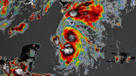
Elsa is currently a tropical storm and is forecast to make landfall Wednesday morning along the west coast of Florida. The storm will turn northeast and take aim at southeast Georgia and the Lowcountry late this afternoon into early Thursday morning.
Hearst OwnedWJCL
Tracking the Tropics
Weather conditions locally will go downhill after 3 pm. The likely impacts will be heavy rain, gusty winds, and isolated tornadoes.
Hearst Owned
Elsa possible tracks
Hearst Owned
Impacts from Elsa
Today is a WJCL 22 Severe High Impact Weather Day. Heavy downpours and localized street flooding are the greatest concerns locally. A widespread 1-3″ of rain is likely, with some locations pick up 5″ or more. Winds may gust to 30-40 mph at times, with gusts around 50mph possible at the coast. You can head here to get your game plan in place now with the free StormTracker22 Hurricane Essential Guide.
Hearst Owned
Possible rain totals
Hearst Owned
Gusty winds tonight from Elsa
Stay on top of the very latest Certified Most Accurate forecast by downloading our free WJCLNews App here.