Tag Archives: continents

The Pacific Is Destined to Vanish as Earth’s Continents Meld Into a New Supercontinent : ScienceAlert

The Pacific Ocean’s days are numbered, according to a new supercomputer simulation of Earth’s ever-drifting tectonic plates.

The good news? Our planet’s oldest ocean still has another 300 million years to go. If the Pacific gets lucky, it might even celebrate its billionth birthday before finally trickling out of existence.

But researchers at Curtin University in Australia think the ocean is likely to be swallowed up before that.

In its final years of life, the Pacific will hardly resemble the vast expanse of blue it does today. Every year, the ocean shrinks a few centimeters, as it’s been doing since it was a superocean surrounding the last supercontinent of Pangea.

This ancient ocean is home to numerous subduction zones; places tectonic plates collide and ride over the top of one other. Colloquially known in the Pacific as the ‘Ring of Fire’, these sites work almost like bath tub drains for the ocean floor.

Each year, a few centimeters of the Pacific plate slips under the Eurasian plate and the Indo-Australian plate, collapsing the distance between North America, Asia and Australia.

Not all scientists agree on what the next supercontinent will look like or how it will form, but in many simulations, the Pacific Ocean is doomed.

While some studies suggest the Atlantic Ocean, which is expanding today, might start to shrink in the future, thereby creating a supercontinent ringed by a super Pacific ocean, researchers at Curtin University disagree.

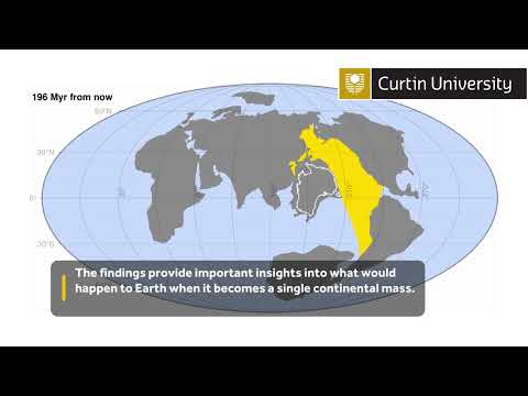
Instead of a second Pangaea-like continent (aka Pangaea Proxima) forming, they argue the world is headed for a supercontinent in which North America collides with Asia, dubbed Amasia.

Poor Australia gets left out of this ‘cute couple’ name, but in 4D geodynamic models, the Southern Hemisphere continent seems to play an important role in plugging up what’s left of the Pacific.

frameborder=”0″ allow=”accelerometer; autoplay; clipboard-write; encrypted-media; gyroscope; picture-in-picture” allowfullscreen>

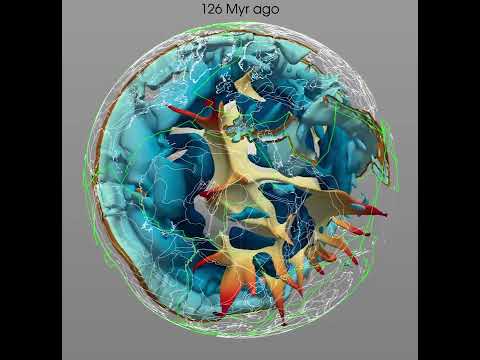
The recent simulations from researchers in Australia are based on realistic plate and mantle parameters from the present and the past, which were then used by a supercomputer to predict the future.

“Over the past two billion years, Earth’s continents have collided together to form a supercontinent every 600 million years, known as the supercontinent cycle,” says Earth scientist and lead author, Chuan Huang.

“By simulating how the Earth’s tectonic plates are expected to evolve using a supercomputer, we were able to show that in less than 300 million years’ time it is likely to be the Pacific Ocean that will close, allowing for the formation of Amasia, debunking some previous scientific theories.”

Contrary to some other supercontinent simulations, this new one suggests the Pacific Ocean, and not the Atlantic Ocean or Caribbean Sea, will be destroyed when Amasia forms.

In the current model, Amasia comes about when the Pacific closes due to the weakening of the upper layer of the ocean’s crust.

“Earth as we know it will be drastically different when Amasia forms. The sea level is expected to be lower, and the vast interior of the supercontinent will be very arid with high daily temperature ranges,” says geoscientist Zheng-Xiang Li.

But this is just the latest study in a long string of supercontinent simulations, all of which have tried to predict what our planet will look like in the future.

One more model is unlikely to end the debate, but this isn’t the only one to predict the demise of the Pacific.

In a scenario where a supercontinent called Novopangaea forms, the Americas collide with Antarctica before crashing into Eurasia and Africa. This cuts off the Pacific in a different way but with similar results.

In another supercontinent scenario, called Aurica, both the Pacific and the Atlantic oceans close for good, and a new ocean basin arises in their stead.

Whatever the outcome, one thing is for sure: Earth and its oceans will never be the same again.

The study was published in the National Science Review.

Read original article here

New Evidence That Giant Asteroid Impacts Created the Continents

Evidence that Earth’s continents were formed by giant meteorite impacts has been uncovered in new research.

New research has uncovered the strongest evidence yet that Earth’s continents were formed by giant meteorite impacts, which were especially common during the first billion years or so of our planet’s four-and-a-half-billion-year history. Curtin University researchers conducted the study, which was published on August 10, 2022, in the journal Nature.

According to Dr. Tim Johnson, from Curtin’s School of Earth and Planetary Sciences, the idea that the continents originally formed at sites of giant meteorite impacts has been around for decades. However, until now there was little solid evidence to support the theory.

“By examining tiny crystals of the mineral zircon in rocks from the Pilbara Craton in Western Australia, which represents Earth’s best-preserved remnant of ancient crust, we found evidence of these giant meteorite impacts,” Dr. Johnson said.

“Studying the composition of oxygen isotopes in these zircon crystals revealed a ‘top-down’ process starting with the melting of rocks near the surface and progressing deeper, consistent with the geological effect of giant meteorite impacts.

“Our research provides the first solid evidence that the processes that ultimately formed the continents began with giant meteorite impacts, similar to those responsible for the extinction of the dinosaurs, but which occurred billions of years earlier.”

Understanding the formation and ongoing evolution of the Earth’s continents is crucial according to Dr. Johnson because these landmasses host the majority of Earth’s biomass, all humans, and almost all of the planet’s important mineral deposits.

“Not least, the continents host critical metals such as lithium, tin, and nickel, commodities that are essential to the emerging green technologies needed to fulfill our obligation to mitigate climate change,” Dr. Johnson said.

“These mineral deposits are the end result of a process known as crustal differentiation, which began with the formation of the earliest landmasses, of which the Pilbara Craton is just one of many.

“Data related to other areas of ancient continental crust on Earth appears to show patterns similar to those recognized in Western Australia. We would like to test our findings on these ancient rocks to see if, as we suspect, our model is more widely applicable.”

Reference: “Giant impacts and the origin and evolution of continents” by Tim E. Johnson, Christopher L. Kirkland, Yongjun Lu, R. Hugh Smithies, Michael Brown and Michael I. H. Hartnady, 10 August 2022, Nature.
DOI: 10.1038/s41586-022-04956-y

Dr. Johnson is affiliated with The Institute for Geoscience Research (TIGeR), Curtin’s flagship earth sciences research institute.


Read original article here

‘Stretching’ of the continents 56 million years drove global warming, study finds

Stretching of the continents 56 million years ago is likely to have caused one of the most extreme episodes of global warming in Earth’s history, new research suggests. 

During this time, the planet experienced an increase in temperature of 5-8°C (9-14°F), culminating in the Paleocene-Eocene Thermal Maximum (PETM), which lasted about 170,000 years.

It caused the extinction of many deep-sea organisms and reshaped the course of evolution of life on Earth. 

Scientists studied the effects of global tectonic forces and volcanic eruptions during the period of environmental change almost 60 million years ago. 

They believe that the extensive stretching of the continental plates in the northern hemisphere – rather like the pulling of a toffee bar that thins and eventually separates – massively reduced the pressures in the Earth’s deep interior.

This then drove intense, but short-lived melting in the mantle – a layer of sticky, molten rock just below the planet’s crust. 

The team, including experts from the universities of Southampton, Edinburgh and Leeds, suggests that the resulting volcanic activity coincided with, and likely caused, a massive burst of carbon release into the atmosphere linked to PETM warming. 

‘Stretching’ of the continents 56 million years ago is likely to have caused one of the most extreme episodes of global warming in Earth’s history, new research suggests. Pictured is a false colour satellite image of the Faroe Islands – one of the locations studied by scientists

The team studied volcanic ash layers and lavas in the laboratories of the Integrated Ocean Drilling Program’s (IODP) Bremen Core Repository, Germany

Scientists found that intense episodes of volcanism were likely responsible for rapid warming during the Paleocene-Eocene Thermal Maximum warming event. Pictured is a volcano in Montserrat, West Indies

WHAT WAS THE PALEOCENE-EOCENE THERMAL MAXIMUM?

The Paleocene-Eocene Thermal Maximum (PETM) was a global warming event that occurred about 56 million years ago.

During this time, scientists estimate about 3,000 to 7,000 gigatons of carbon accumulated over a period of 3,000 to 20,000 years.

This lead global temperatures to spike by 5 to 8 degrees Celsius (9 to 14 degrees Fahrenheit), bringing the average as high as 23 degrees Celsius (73 degrees Fahrenheit). 

It lead to dramatic changes in Earth’s climate, driving major organisms to extinction and forcing others to migrate.

<!- - ad: https://mads.dailymail.co.uk/v8/de/sciencetech/none/article/other/mpu_factbox.html?id=mpu_factbox_1 - ->

Advertisement

Dr Tom Gernon, an associate professor of Earth science at the University of Southampton and lead author of the study, said: ‘Despite the importance and wider relevance of the PETM to global change today, the underlying cause is highly debated.

‘It’s generally agreed that a sudden and massive release of the greenhouse gas, carbon, from the Earth’s interior must have driven this event, yet the scale and pace of warming is very hard to explain by conventional volcanic processes.’

The scientists found evidence from rock drilled from the seafloor for a widespread episode volcanic activity lasting 200,000 years, which coincided with the PETM.

Using archives of rock drilled beneath the seafloor near the edge of the Atlantic Ocean, the team found evidence of an abrupt and widespread episode of volcanic activity across the North Atlantic Ocean that lasted just over 200,000 years, strikingly similar to the duration of the PETM.

This finding prompted the researchers to investigate a broader expanse of the North Atlantic region, including Greenland and the Faroe Islands. 

Here, they found that kilometre-thick piles of lava that started to erupt just before the PETM show unusual compositions that point to a significant increase in the amount of melting of the uppermost solid part of Earth’s mantle beneath the continent.

Dr Gernon said this would have led to a rapid increase of carbon being released, which would have led to the global warming.

Fragments of lava from the Atlantic are pictured here under a microscope

The volcanism occurred as the North Atlantic region was in the final stages of rifting, or breaking apart, in some ways similar to the geological processes occurring today in the East African Rift Valley, pictured

The intense volcanic activity occurred just as the continental landmass that united Greenland and Europe was most intensely stretched by plate tectonic forces. 

Eventually, North America and Greenland finally separated from Europe, leading to the birth of the North Atlantic Ocean. 

Scientists believe it was this final phase of stretching that brought about substantial melting in the Earth’s mantle, leading to massive carbon release, and in-turn, global warming. 

Dr Thea Hincks, senior research fellow at the University of Southampton and co-author on the study, said: ‘Using physically realistic estimates of the key characteristics of these volcanic systems, we show that the amount of carbon needed to drive warming could have been attained by enhanced melting.’

Dr Gernon added: ‘Such rapid events cause a fundamental reorganisation of Earth’s surface environment, altering vast ecosystems.’

The study has been published in the journal Nature Geoscience.

WHEN WAS THE PALEOCENE AND HOW DID IT IMPACT BRITAIN’S CLIMATE?

The Paleoscene (‘old recent’) is a geological period that stretched from 66 to 56 million years ago.  

During this period, the Earth’s climate was up to 15°C (27°F) warmer than it is today.

As a result, tropical and sub tropical forests extended further north and would have been widespread in the UK.

At the time there had not been an ice age for 100 million years.

The distance between Europe and Greenland was a tenth of what it is today.

There was massive volcanic activity between Baffin Island and northwest Europe that extended as far south as Bristol Channel. 

The shape of the continents were similar to those today except they were arranged differently due to tectonic plates. Britain, Ireland and Norway were all landlocked and the Arctic sea was almost completely surrounded by land

Britain, Ireland and Norway were all landlocked and the Arctic sea was almost completely surrounded by land.

The shape of the continents were similar to those today except they were arranged differently due to tectonic plates, according to a website dedicated to the Paleocene. 

Most of the world’s most famous geological features would not have been recognisable, including mountain ranges like the Alps and Himalayas which formed during the Tertiary period. 

Prior to the Paleocene-Eocene Thermal Maximum (PETM) – which occurred around 55 million years ago – non-avian dinosaurs had been extinct for around ten million years.

Early mammals, amphibians, reptiles, insects and flowering plants were the dominant forms of life.

Mammals were generally small, had short legs and five toes on each foot.

<!- - ad: https://mads.dailymail.co.uk/v8/de/sciencetech/none/article/other/mpu_factbox.html?id=mpu_factbox_2 - ->

Advertisement

Read original article here

Two Giant Blobs Lurk Deep Inside Earth, And It Looks Like They’re Shape-Shifters

Deep in the Earth beneath us lie two blobs the size of continents. One is under Africa, the other under the Pacific Ocean.

The blobs have their roots 2,900 km (1,800 miles) below the surface, almost halfway to the centre of the Earth. They are thought to be the birthplace of rising columns of hot rock called “deep mantle plumes” that reach Earth’s surface.


When these plumes first reach the surface, giant volcanic eruptions occur – the kind that contributed to the extinction of the dinosaurs 65.5 million years ago. The blobs may also control the eruption of a kind of rock called kimberlite, which brings diamonds from depths 120-150 km (and in some cases up to around 800 km) to Earth’s surface.

Scientists have known the blobs existed for a long time, but how they have behaved over Earth’s history has been an open question. In new research, we modeled a billion years of geological history and discovered the blobs gather together and break apart much like continents and supercontinents.

(Ömer Bodur)

Above: Earth’s blobs as imaged from seismic data. The African blob is at the top and the Pacific blob at the bottom.

A model for Earth blob evolution

The blobs are in the mantle, the thick layer of hot rock between Earth’s crust and its core. The mantle is solid but slowly flows over long timescales. We know the blobs are there because they slow down waves caused by earthquakes, which suggests the blobs are hotter than their surroundings.

Scientists generally agree the blobs are linked to the movement of tectonic plates at Earth’s surface. However, how the blobs have changed over the course of Earth’s history has puzzled them.


One school of thought has been that the present blobs have acted as anchors, locked in place for hundreds of millions of years while other rock moves around them. However, we know tectonic plates and mantle plumes move over time, and research suggests the shape of the blobs is changing.

Our new research shows Earth’s blobs have changed shape and location far more than previously thought. In fact, over history they have assembled and broken up in the same way that continents and supercontinents have at Earth’s surface.

We used Australia’s National Computational Infrastructure to run advanced computer simulations of how Earth’s mantle has flowed over a billion years.

These models are based on reconstructing the movements of tectonic plates. When plates push into one another, the ocean floor is pushed down between them in a process known as subduction.

The cold rock from the ocean floor sinks deeper and deeper into the mantle, and once it reaches a depth of about 2,000 km it pushes the hot blobs aside.

Above: The past 200 million years of Earth’s interior. Hot structures are in yellow to red (darker is shallower) and cold structures in blue (darker is deeper).

We found that just like continents, the blobs can assemble – forming “superblobs” as in the current configuration – and break up over time.


A key aspect of our models is that although the blobs change position and shape over time, they still fit the pattern of volcanic and kimberlite eruptions recorded at Earth’s surface. This pattern was previously a key argument for the blobs as unmoving “anchors”.

Strikingly, our models reveal the African blob assembled as recently as 60 million years ago – in stark contrast to previous suggestions the blob could have existed in roughly its present form for nearly ten times as long.

Remaining questions about the blobs

How did the blobs originate? What exactly are they made of? We still don’t know.

The blobs may be denser than the surrounding mantle, and as such they could consist of material separated out from the rest of the mantle early in Earth’s history. This could explain why the mineral composition of the Earth is different from that expected from models based on the composition of meteorites.

Alternatively, the density of the blobs could be explained by the accumulation of dense oceanic material from slabs of rock pushed down by tectonic plate movement.


Regardless of this debate, our work shows sinking slabs are more likely to transport fragments of continents to the African blob than to the Pacific blob.

Interestingly, this result is consistent with recent work suggesting the source of mantle plumes rising from the African blob contains continental material, whereas plumes rising from the Pacific blob do not.

Tracking the blobs to find minerals and diamonds

While our work addresses fundamental questions about the evolution of our planet, it also has practical applications.

Our models provide a framework to more accurately target the location of minerals associated with mantle upwelling. This includes diamonds brought up to the surface by kimberlites that seem to be associated with the blobs.

Magmatic sulfide deposits, which are the world’s primary reserve of nickel, are also associated with mantle plumes. By helping target minerals such as nickel (an essential ingredient of lithium-ion batteries and other renewable energy technologies) our models can contribute to the transition to a low-emission economy.

Nicolas Flament, Senior Lecturer, University of Wollongong; Andrew Merdith, Research fellow, University of Leeds; Ömer F. Bodur, Postdoctoral research fellow, University of Wollongong, and Simon Williams, Research Fellow, Northwest University, Xi’an.

This article is republished from The Conversation under a Creative Commons license. Read the original article.


Read original article here

Mysterious and unstable ‘blobs’ the size of continents beneath Earth’s surface baffle scientists

For years scientists have been scratching their heads over two unexplained massive blobs of rock under Earth’s surface.

Many theories have been thrown around since their discovery in the 1980s, including claims that they could be huge fragments of an alien world.

The blobs of rock under Earth’s crust are each the size of a continent and 100 times taller than Mount Everest.

One sits under Africa, while the other can be found under the Pacific Ocean.

In pursuit of answers, a pair of experts have made some interesting new discoveries about the two gigantic masses.

As suspected, it turns out, the blob under Africa is a lot higher.

In fact, it’s twice the height of the one on the opposite side of the world, measuring in about 620 miles taller.

And that’s not all.

Crucially, scientists have found that the African blob of rock is also less dense and less stable.

It’s not clear why things are this way but it could be a reason for the continent having significantly more supervolcano eruptions over hundreds of millions of years, compared to its counterpart on the other side.

A 3D model of the blobs beneath Earth’s mantle in Africa.
Mingming Li/ASU

“This instability can have a lot of implications for the surface tectonics, and also earthquakes and supervolcanic eruptions,” said Qian Yuan, from Arizona State University.

These thermo-chemical materials – officially known as large low-shear-velocity provinces (LLSVPs) – were studied by looking at data from seismic waves and running hundreds of simulations.

While we now know they both have different compositions, we’re yet to work out how this affects the surrounding mantle, which is found between the planet’s core and the crust.

And most importantly, we’re no closer to figuring out where these mysterious blobs came from.

“Our combination of the analysis of seismic results and the geodynamic modeling provides new insights on the nature of the Earth’s largest structures in the deep interior and their interaction with the surrounding mantle,” Yuan added.

“This work has far-reaching implications for scientists trying to understand the present-day status and the evolution of the deep mantle structure, and the nature of mantle convection.”

And so, the investigation continues.

The research was published in the Nature Geoscience journal.

This article originally appeared on The Sun and was reproduced here with permission.

Read original article here

Scientists Found a Cradle of Life Under Antarctic Ice Sheet

A hot water drilling rig on Antarctica.
Photo: Sophie Berger, AWI

Antarctica is often portrayed as a barren wasteland of ice and snow, about as inhospitable as any place on Earth. But a team of researchers just pulled up a huge amount of life from underneath the frozen continent, a testament to the tenacity of these extremophile organisms.

The life was found around 650 feet (200 meters) below the Ekström Ice Shelf, in waters that are 28 degrees Fahrenheit (minus-2 degrees Celsius) and pitch black. Seventy-seven different species of moss animals called bryozoans and worms were found, a veritable cornucopia of creatures that changes how researchers think of these extreme submarine environments. The team’s research was published this week in Current Biology.

“This has massively increased the known species from this least-known habitat,” David Barnes, a marine ecologist at the British Antarctic Survey, said in an email. Though some of the animals had already been found in other parts of Antarctica, the unusual habitat for this cache is a first. “This may give us clues into how life in polar seas survived glaciations,” Barnes added.

The environment is difficult to access, being beneath hundreds of feet of solid ice. To actually get a look at what dwells below, the research team bored a hole through the ice using a specialized hot water drill. Then, the team dropped cameras into the borehole. They also radiocarbon dated some of the bryozoan and bivalves they found, to see how long life had been there.

“Carbon dating of dead fragments of these seafloor animals varied from current to 5,800 years,” said co-author Gerhard Kuhn, an earth scientist at the Alfred Wegener Institute in Bremerhaven, Germany, in a British Antarctic Survey release. “So, despite living 3-9 kilometers [2-6 miles] from the nearest open water, an oasis of life may have existed continuously for nearly 6,000 years under the ice shelf.”

Some of the bryozoans the team found.
Photo: Dave Barnes, BAS

Life persevering in such extreme conditions is impressive. Some regions under the Antarctic ice have life, despite being in complete darkness for millennia. Some microbes subsist on pulverized bedrock that settles in the sediment beneath the continent. But larger organisms also manage to get by under unthinkable challenging conditions; a different team of biologists found sponges half a mile (1 kilometer) below Antarctica’s ice sheet, a discovery one of the researchers likened to “finding a bit of the rainforest in the middle of the Sahara.” Though the recent team’s discovery wasn’t as deep, it still expands the number of environments known to sustain life.

“There are many things we can learn from this unusual (and quite large) habitat,” Barnes said. “Many polar species can cope with much lower levels of food than thought (so although surface polar oceans are warming they may be able to survive in deeper (food-poor) waters.”

Despite how inaccessible the habitat is, though, it is changing along with the rest of the planet. As climate change warms the planet and hastens the collapse of Antarctic ice shelves, these pitch-black inland habitats could soon be exposed to the open ocean or be altered in other ways. Even if those changes could make some locations a happier home for photosynthesizing creatures that can soak up the sun, the unique environment that currently exists under the Ekström ice shelf will be gone.

So far, only about 10 square feet (1 square meter) of the 620,000-square-mile (1.6-million-square-kilometer) habitat has actually been observed, leading to fears that some of the biodiversity under Antarctica could undergo anonymous extinction. “It is a major tragedy that one of Earth’s least known, disturbed and unique habitats could be lost before we even know it,” Barnes said. “There are likely to be many societally important answers to how our planet functions there.”

More: Massive Antarctic Lake Disappears in Just a Few Days

Read original article here

First Continents Bobbed to the Surface of Earth 500 Million Years Earlier Than Thought

Most people know that the land masses on which we all live represent just 30% of Earth’s surface, and the rest is covered by oceans.

The emergence of the continents was a pivotal moment in the history of life on Earth, not least because they are the humble abode of most humans. But it’s still not clear exactly when these continental landmasses first appeared on Earth, and what tectonic processes built them.

Our research, published in Proceedings of the National Academy of Sciences, estimates the age of rocks from the most ancient continental fragments (called cratons) in India, Australia and South Africa. The sand that created these rocks would once have formed some of the world’s first beaches.

We conclude that the first large continents were making their way above sea level around 3 billion years ago – much earlier than the 2.5 billion years estimated by previous research.

A 3-billion-year-old beach

When continents rise above the oceans they start to erode. Wind and rain break rocks down into grains of sand, which are transported downstream by rivers and accumulate along coastlines to form beaches.

These processes, which we can observe in action during a trip to the beach today, have been operating for billions of years. By scouring the rock record for signs of ancient beach deposits, geologists can study episodes of continent formation that happened in the distant past.

Left: sandstone formations (with ruler for scale); right: microscopic images of zircon grains. Credit: Author provided

The Singhbhum craton, an ancient piece of continental crust that makes up the eastern parts of the Indian subcontinent, contains several formations of ancient sandstone. These layers were originally formed from sand deposited in beaches, estuaries and rivers, which was then buried and compressed into rock.

We determined the age of these deposits by studying microscopic grains of a mineral called zircon, which is preserved within these sandstones. This mineral contains tiny amounts of uranium, which very slowly turns into lead via radioactive decay. This allows us to estimate the age of these zircon grains, using a technique called uranium-lead dating, which is well suited to dating very old rocks.

The zircon grains reveal that the Singhbhum sandstones were deposited around 3 billion years ago, making them some of the oldest beach deposits in the world. This also suggests a continental landmass had emerged in what is now India by at least 3 billion years ago.

Interestingly, sedimentary rocks of roughly this age are also present in the oldest cratons of Australia (the Pilbara and Yilgarn cratons) and South Africa (the Kaapvaal Craton), suggesting multiple continental landmasses may have emerged around the globe at this time.

Rise above it

How did rocky continents manage to rise above the oceans? A unique feature of continents is their thick, buoyant crust, which allows them to float on top of Earth’s mantle, just like a cork in water. Like icebergs, the top of continents with thick crust (typically more than 45km thick) sticks out above the water, whereas continental blocks with crusts thinner than about 40km remain submerged.

So if the secret of the continents’ rise is due to their thickness, we need to understand how and why they began to grow thicker in the first place.

Granites are some of the least dense and most buoyant types of rock (pen included for scale). Credit: Author provided

Most ancient continents, including the Singhbhum Craton, are made of granites, which formed through the melting of pre-existing rocks at the base of the crust. In our research, we found the granites in the Singhbhum Craton formed at increasingly greater depths between about 3.5 billion and 3 billion years ago, implying the crust was becoming thicker during this time window.

Because granites are one of the least dense types of rock, the ancient crust of the Singhbhum Craton would have become progressively more buoyant as it grew thicker. We calculate that by around 3 billion years ago, the continental crust of the Singhbhum Craton had grown to be about 50km thick, making it buoyant enough to begin rising above sea level.

The rise of continents had a profound influence on the climate, atmosphere and oceans of the early Earth. And the erosion of these continents would have provided chemical nutrients to coastal environments in which early photosynthetic life was flourishing, leading to a boom in oxygen production and ultimately helping to create the oxygen-rich atmosphere in which we thrive today.

Erosion of the early continents would have also helped in sequestering carbon dioxide from the atmosphere, leading to global cooling of the early Earth. Indeed, the earliest glacial deposits also happen to appear in the geological record around 3 billion years ago, shortly after the first continents emerged from the oceans.

Written by:

  • Priyadarshi Chowdhury – Postdoctoral research fellow, Monash University
  • Jack Mulder – Research Associate, The University of Queensland
  • Oliver Nebel – Associate Professor, Monash University
  • Peter Cawood – Professor and ARC Laureate Fellow, Monash University

Originally published on The Conversation.


Read original article here

Authorities on 3 Continents Crack Down on Dark Web Drug Sales

Law enforcement agencies on three continents have disrupted a global drug trafficking operation on the dark web, resulting in the arrests of more than 150 people and the seizure of $31.6 million in cash and virtual currencies and substantial quantities of opioids and other drugs, the Justice Department said on Tuesday.

The results of the sting, called Operation Dark HunTor, followed the takedown in January of DarkMarket, at the time the world’s largest online marketplace for illicit goods, located in an encrypted and relatively hidden corner of the internet.

When German authorities arrested DarkMarket’s alleged operator and seized the site’s infrastructure, they recovered a trove of evidence that they subsequently provided to dozens of law enforcement teams across the world for follow-up investigations.

Over the last 10 months, the F.B.I. and other international law enforcement agencies used the information from DarkMarket to identify drug vendors and buyers who had sold drugs, weapons and other illicit services across Australia, Bulgaria, France, Germany, Italy, the Netherlands, Switzerland, Britain and the United States.

They were able to match vendor accounts to individuals selling illicit goods on other marketplaces, some still active and some not.

Authorities seized amphetamines, cocaine, opioids, MDMA and several other drugs and counterfeit medicines, as well as 45 firearms.

The results of the operation “send one clear message to those hiding on the dark net peddling illegal drugs: There is no dark internet,” Deputy Attorney General Lisa O. Monaco said in a statement. “We can and we will shine a light.”

As part of the announcement on Tuesday, the Justice Department unsealed indictments against nearly a dozen defendants in California, New York, Tennessee, Virginia and Washington State who were accused of selling illicit goods on the dark internet, money laundering and other crimes.

Ms. Monaco said that investigators had looked for people who had used the dark internet to sell illicit drugs and drugmaking equipment that had helped fuel America’s opioid crisis. Prosecutors targeted people who had operated home laboratories to manufacture fake prescription pain drugs that contained fentanyl, methamphetamine and other illegal, lethal drugs.

Italian authorities also shut down two more dark web marketplaces where more than 40,000 advertisements for illegal products had been posted. Authorities then arrested four people accused of running the sites and seized cryptocurrencies worth more than $4 million.

The U.S. operation was undertaken by the Joint Criminal Opioid and Darknet Enforcement team, an F.B.I.-led initiative created in 2018 to disrupt and dismantle the online sale of illicit drugs, weapons and other illegal services.

U.S. officials said on Tuesday that a number of investigations were underway and that federal prosecutions were being conducted in more than 15 districts in California, Florida, Massachusetts, Nebraska, Nevada, New York, Ohio, Texas, Virginia, Rhode Island, Tennessee, Washington State and Washington, D.C.

Read original article here

Watch a Billion Years of Shifting Tectonic Plates in 40 Mesmerising Seconds

The tectonic plates that cover Earth like a jigsaw puzzle move about as fast as our fingernails grow, but over the course of a billion years that’s enough to travel across the entire planet – as a fascinating new video shows.


In one of the most complete models of tectonic plate movements ever put together, scientists have condensed a billion years of movement into a 40-second video clip, so we can see how these giant slabs of rock have interacted over time.

As they move, the plates affect climate, tidal patterns, animal movements and their evolution, volcanic activity, the production of metals and more: they’re more than just a covering for the planet, they’re a life support system that affects everything that lives on the surface.

“For the first time a complete model of tectonics has been built, including all the boundaries,” geoscientist Michael Tetley, who completed his PhD at the University of Sydney, told Euronews.

“On a human timescale, things move in centimetres per year, but as we can see from the animation, the continents have been everywhere in time. A place like Antarctica that we see as a cold, icy inhospitable place today, actually was once quite a nice holiday destination at the equator.”

The moving and sliding of the plates is quite a sight if you check out the video – land masses that are near neighbours become distant cousins and vice versa, and you might be surprised at just how recently it was that the countries and continents settled into the positions that we know today.


Understanding these movements and patterns is crucial if scientists want to predict how habitable our planet will be in the future, and where we’re going to find the metal resources we need to ensure a clean energy future.

Plate movement is estimated through the study of the geological record – the magnetism that provides data on substrates’ historic positions in respect to Earth’s spin axis and the types of material locked in rock samples that help match the pieces of past geological plate puzzles together.

Here the team went to great lengths to choose and combine the most suitable models currently available, looking at both the movements of the continents and the interactions along plate boundaries.

“Planet Earth is incredibly dynamic, with the surface composed of plates that constantly jostle each other in a way unique among the known rocky planets,” says geoscientist Sabin Zahirovic, from the University of Sydney.

“These plates move at the speed fingernails grow, but when a billion years is condensed into 40 seconds a mesmerising dance is revealed. Oceans open and close, continents disperse and periodically recombine to form immense supercontinents.”


The further scientists go into the past, the more difficult it becomes to estimate how plates have moved, and in this case the Neoproterozoic to Cambrian (1,000 to 520 million years ago) eras in particular were carefully charted and brought in line to match the more modern records that we have.

Questions remain about how these plates first formed and when this formation happened, but every new data point helps us to understand the ancient history of Earth – even accounting for missing plates in some models.

The scientists admit that their work lacks some finer detail – stretched as it is across the entire planet and a billion years – but they’re hoping that it can act as a useful resource and foundation for the future study of these movements and the impact they have on everything else on the planet.

“Our team has created an entirely new model of Earth evolution over the last billion years,” says geoscientist Dietmar Müller, from the University of Sydney.

“Our planet is unique in the way that it hosts life. But this is only possible because geological processes, like plate tectonics, provide a planetary life-support system.”

The research has been published in Earth-Science Reviews.


Read original article here